
Dhoby Ghaut MRT Station
Dhoby Ghaut MRT station sits underground beneath the eastern end of Orchard Road, in the Dhoby Ghaut area of the Museum Planning Area in central Singapore. It is an interchange served by three lines: the North South Line (NS24), the North East Line (NE6) and the Circle Line (CC1), where it is the first station on the line. The station is built into the commercial development The Atrium@Orchard, so you can walk from the platforms into shops and offices without going outside.
Dhoby Ghaut on the North South Line map
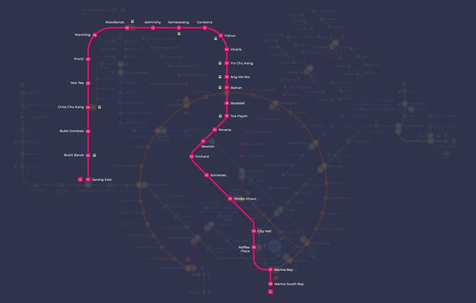
Dhoby Ghaut MRT station at a glance
| Station codes | NS24NE6CC1 |
|---|---|
| Lines | North South Line North East Line Circle Line |
| Line colour | Red line (North South Line) Purple line (North East Line) Yellow line (Circle Line) |
| Interchange | Yes, change between 3 lines here |
| Chinese name | 多美歌 |
| Tamil name | டோபி காட் |
| Opened | 12 December 1987 (38 years ago) |
| Operator | SMRT Trains and SBS Transit |
| Station type | Underground |
| Platforms | 6 (3 island platforms) |
| Address | 11 Orchard Road, Singapore 238826 |
| Daily ridership | About 30,224 passengers a day (2024) |
| Next stations | |
| Train times | North South Line: first train leaves the terminus at 5:16 AM, last train 11:48 PM North East Line: first train leaves the terminus at 5:39 AM, last train 11:55 PM Circle Line: first train leaves the terminus at 5:37 AM, last train 11:56 PM Full first and last train guide |
Opening date, operator and ridership figures are LTA data as recorded on Wikipedia.
See Dhoby Ghaut on the map. The interactive map opens with this station highlighted, so you can trace the route from where you are.
Because three lines meet here, a large share of passengers use the station simply to change trains. Many others are heading to the malls at this end of Orchard Road, to Fort Canning, or to the museums a short walk away. Landmarks around the station include The Istana, MacDonald House, Plaza Singapura and Dhoby Ghaut Green.
History of Dhoby Ghaut MRT station
The station first welcomed passengers on 12 December 1987 as part of the first phase of the MRT network, and it has been on the North South Line since the network was split into separate lines on 28 October 1989. North East Line platforms followed on 20 June 2003, and the Circle Line platforms opened on 17 April 2010, which made Dhoby Ghaut the first station on the network to link three lines. Building the North East Line section was no small task: the Stamford Canal, which ran straight through the site, had to be moved, and part of the hill at Mount Sophia was cut away to make room.
Inside Dhoby Ghaut MRT station
This is one of the deepest and largest stations on the network, spread over five underground levels and reaching 28 metres below ground at its lowest point, so allow a few extra minutes when changing between lines. Lifts have provided step-free access since September 2000. Look out for the artwork along the way: there are three Art-in-Transit pieces in the North East Line and Circle Line areas, a set of Art Seats on the Circle Line platforms, and an artwork above the North South Line platforms.
For most people, Dhoby Ghaut MRT station is the starting point for shopping and sightseeing at the quieter end of Orchard Road. Plaza Singapura is about 100 metres away, roughly a two minute walk, and The Cathay is around four minutes on foot. If you prefer history and green space, the Istana Heritage Gallery and the Fort Canning Tree Tunnel are each about a four minute walk, while the National Museum of Singapore is around seven minutes away. Further along, Orchard Central and the restored shophouses of Emerald Hill can be reached in under a quarter of an hour on foot.
Around Dhoby Ghaut MRT station
Dhoby Ghaut sits at the edge of the Orchard Road shopping belt and the green slopes of Fort Canning, making it a mix of retail, cultural and leisure uses. Plaza Singapura is immediately beside the station, while the National Museum of Singapore and the Battlebox Visitor Centre sit a short walk away on the hill. The area draws shoppers, museum visitors and those heading into the parkland around Fort Canning.
| Place | Type | Distance | Why go |
|---|---|---|---|
| Plaza Singapura | Shopping mall | About 100 m (~2 min walk) | Visit Plaza Singapura for a wide range of shops, dining and entertainment. |
| The Cathay | Shopping mall | About 230 m (~4 min walk) | Visit The Cathay for cinema screenings, food and lifestyle shopping. |
| Istana Heritage Gallery | Museum | About 240 m (~4 min walk) | Visit the Istana Heritage Gallery to learn about Singapore's presidential residence. |
| Fort Canning Tree Tunnel | Attraction | About 270 m (~4 min walk) | Visit the Fort Canning Tree Tunnel for a scenic, photogenic garden walkway. |
| Battlebox Visitor Centre | Museum | About 390 m (~6 min walk) | Visit the Battlebox Visitor Centre to explore a preserved Second World War underground command centre. |
| National Museum of Singapore | Museum | About 460 m (~7 min walk) | Visit the National Museum of Singapore for exhibitions covering Singapore's history and culture. |
| Orchard Central | Shopping mall | About 650 m (~11 min walk) | Visit Orchard Central for shopping, dining and art installations along Orchard Road. |
| Emerald Hill | Attraction | About 790 m (~13 min walk) | Visit Emerald Hill for a quiet street of conserved Peranakan shophouses and heritage architecture. |
Places and straight-line distances from OpenStreetMap data (© OpenStreetMap contributors). Actual walking routes may be longer.
How to get to Dhoby Ghaut by MRT
Worked out from the network map. Stop counts are station to station and do not include walking or waiting time.
| From Changi Airport | Take the East West Line from Changi Airport to City Hall (11 stops), then change to the North South Line from City Hall to Dhoby Ghaut (1 stop). About 12 stops with 1 change. |
|---|---|
| From Orchard | Take the North South Line from Orchard to Dhoby Ghaut (2 stops). About 2 stops, no changes. |
| From City Hall | Take the North South Line from City Hall to Dhoby Ghaut (1 stop). About 1 stops, no changes. |
| From Jurong East | Take the East West Line from Jurong East to Outram Park (8 stops), then change to the North East Line from Outram Park to Dhoby Ghaut (3 stops). About 11 stops with 1 change. |
| From Woodlands | Take the North South Line from Woodlands to Dhoby Ghaut (15 stops). About 15 stops, no changes. |
| From HarbourFront | Take the North East Line from HarbourFront to Dhoby Ghaut (4 stops). About 4 stops, no changes. |
Fares from Dhoby Ghaut MRT station
A trip from Dhoby Ghaut to Changi Airport (about 20 km) costs S$2.30 on an adult SimplyGo or EZ-Link card. Fares are charged by distance, so the table below shows the estimated adult card fare from Dhoby Ghaut to the main hubs, the early bird fare for journeys that start before 7.45am on weekdays, and the fare that applies from 26 December 2026.
| To | Distance | Adult card | Before 7.45am | From 26 Dec 2026 |
|---|---|---|---|---|
| Changi Airport | about 20 km, 12 stops | S$2.30 | S$1.80 | S$2.43 |
| Orchard | about 2 km, 2 stops | S$1.28 | S$0.78 | S$1.40 |
| City Hall | about 1 km, 1 stop | S$1.28 | S$0.78 | S$1.40 |
| Raffles Place | about 2 km, 2 stops | S$1.28 | S$0.78 | S$1.40 |
| Jurong East | about 16 km, 11 stops | S$2.15 | S$1.65 | S$2.28 |
| Woodlands | about 26 km, 15 stops | S$2.42 | S$1.92 | S$2.55 |
| HarbourFront | about 6 km, 4 stops | S$1.59 | S$1.09 | S$1.72 |
| Marina Bay | about 3 km, 3 stops | S$1.38 | S$0.88 | S$1.51 |
Estimated from the route distance between stations and the Public Transport Council fare table in force from 27 December 2025. The exact fare can differ by one band. Cash fares are higher. Use the fare calculator for any other journey, or check your fare on the SimplyGo app.
Tips for using Dhoby Ghaut MRT station
- Plaza Singapura is the closest major destination and is reachable on foot within a couple of minutes, making it ideal if you want to head straight from the train to shops or food.
- The Fort Canning Tree Tunnel, Battlebox Visitor Centre and National Museum of Singapore are all uphill from the station, so allow a little extra time and energy for those walks, particularly in the midday heat.
- Dhoby Ghaut is an interchange between the North South Line and the North East Line, so plan your onward journey in advance to make the most of the connections available here.
- For Orchard Central and Emerald Hill, the walking distance is roughly 10 to 13 minutes, so consider riding one stop north on the North South Line to Orchard station to shorten your walk if you are heading specifically to those destinations.
All stations on the North South Line
In order along the line, with Dhoby Ghaut marked. Stations with their own guide are linked.
| Code | Station | Interchange |
|---|---|---|
| NS1 | Jurong East | EW / NS |
| NS2 | Bukit Batok | None |
| NS3 | Bukit Gombak | None |
| NS4 | Choa Chu Kang | NS / BP |
| NS5 | Yew Tee | None |
| NS7 | Kranji | None |
| NS8 | Marsiling | None |
| NS9 | Woodlands | NS / TE |
| NS10 | Admiralty | None |
| NS11 | Sembawang | None |
| NS12 | Canberra | None |
| NS13 | Yishun | None |
| NS14 | Khatib | None |
| NS15 | Yio Chu Kang | None |
| NS16 | Ang Mo Kio | None |
| NS17 | Bishan | NS / CC |
| NS18 | Braddell | None |
| NS19 | Toa Payoh | None |
| NS20 | Novena | None |
| NS21 | Newton | NS / DT |
| NS22 | Orchard | TE / NS |
| NS23 | Somerset | None |
| NS24 | Dhoby Ghaut (you are here) | NS / NE / CC |
| NS25 | City Hall | EW / NS |
| NS26 | Raffles Place | NS / EW |
| NS27 | Marina Bay | CE / TE / NS |
| NS28 | Marina South Pier | None |
Read the full North South Line guide.
All stations on the North East Line
In order along the line, with Dhoby Ghaut marked. Stations with their own guide are linked.
| Code | Station | Interchange |
|---|---|---|
| NE1 | HarbourFront | CC / NE |
| NE3 | Outram Park | TE / EW / NE |
| NE4 | Chinatown | DT / NE |
| NE5 | Clarke Quay | None |
| NE6 | Dhoby Ghaut (you are here) | NS / NE / CC |
| NE7 | Little India | DT / NE |
| NE8 | Farrer Park | None |
| NE9 | Boon Keng | None |
| NE10 | Potong Pasir | None |
| NE11 | Woodleigh | None |
| NE12 | Serangoon | CC / NE |
| NE13 | Kovan | None |
| NE14 | Hougang | None |
| NE15 | Buangkok | None |
| NE16 | Sengkang | NE / STC |
| NE17 | Punggol | NE / PTC |
| NE18 | Punggol Coast | None |
Read the full North East Line guide.
All stations on the Circle Line
In order along the line, with Dhoby Ghaut marked. Stations with their own guide are linked.
| Code | Station | Interchange |
|---|---|---|
| CC1 | Dhoby Ghaut (you are here) | NS / NE / CC |
| CC2 | Bras Basah | None |
| CC3 | Esplanade | None |
| CC4 | Promenade | CC / DT |
| CC5 | Nicoll Highway | None |
| CC6 | Stadium | None |
| CC7 | Mountbatten | None |
| CC8 | Dakota | None |
| CC9 | Paya Lebar | CC / EW |
| CC10 | MacPherson | CC / DT |
| CC11 | Tai Seng | None |
| CC12 | Bartley | None |
| CC13 | Serangoon | CC / NE |
| CC14 | Lorong Chuan | None |
| CC15 | Bishan | NS / CC |
| CC16 | Marymount | None |
| CC17 | Caldecott | CC / TE |
| CC19 | Botanic Gardens | DT / CC |
| CC20 | Farrer Road | None |
| CC21 | Holland Village | None |
| CC22 | Buona Vista | EW / CC |
| CC23 | one-north | None |
| CC24 | Kent Ridge | None |
| CC25 | Haw Par Villa | None |
| CC26 | Pasir Panjang | None |
| CC27 | Labrador Park | None |
| CC28 | Telok Blangah | None |
| CC29 | HarbourFront | CC / NE |
| CC30 | Keppel | None |
| CC31 | Cantonment | None |
| CC32 | Prince Edward Road | None |
Read the full Circle Line guide.
Dhoby Ghaut MRT station: common questions
Which line is Dhoby Ghaut MRT station on?
Dhoby Ghaut is on the North South Line and the North East Line and the Circle Line. Its station codes are NS24 and NE6 and CC1.
Is Dhoby Ghaut an interchange station?
Yes. You can change between the North South Line and the North East Line and the Circle Line inside the station without leaving the paid area.
What time is the first and last train at Dhoby Ghaut?
Times below are for the first and last train leaving the line terminus; trains reach Dhoby Ghaut a few minutes later depending on its position on the line. North South Line first train 5:16 AM, last train 11:48 PM. North East Line first train 5:39 AM, last train 11:55 PM. Circle Line first train 5:37 AM, last train 11:56 PM. Check the operator for holiday changes.
What is near Dhoby Ghaut MRT station?
The area around Dhoby Ghaut has a mix of shopping malls, museums and leisure attractions. Nearby places include Plaza Singapura, The Cathay, the Istana Heritage Gallery, the Fort Canning Tree Tunnel, the Battlebox Visitor Centre, the National Museum of Singapore, Orchard Central and Emerald Hill.
Which shopping mall is closest to Dhoby Ghaut MRT station?
Plaza Singapura is the closest shopping mall, approximately 100 metres away and roughly a 2-minute walk from the station.
How far is the National Museum of Singapore from Dhoby Ghaut MRT station?
The National Museum of Singapore is approximately 460 metres from Dhoby Ghaut station, which is roughly a 7-minute walk.
How do I get to Dhoby Ghaut from Changi Airport by MRT?
Take the East West Line from Changi Airport to City Hall (11 stops), then change to the North South Line from City Hall to Dhoby Ghaut (1 stop). About 12 stops with 1 change.
Sources: station codes, line colours and interchanges from the LTA rail system map; operating hours from SMRT and SBS Transit. Last reviewed October 2026.
News and guides mentioning Dhoby Ghaut
- Vomit on MRT: What to Do When Your Cabin Is Soiled 6 Nov 2026
- Travelling with luggage on Singapore MRT: lifts, wide gates and quiet times 6 Nov 2026
- Deepavali Eve Train Extensions: Which Lines Run Later on 8 November 6 Nov 2026
- SBS Transit Disability Support Training: 70% of Staff by 2030 6 Nov 2026
Plan the rest of the trip
Every station on the North South Line and the North East Line is listed on its line guide, with the full route and interchanges. For times, see the first and last train guide, and for the whole network in one view use the interactive Singapore MRT map or the PDF map.
Exits and buses at Dhoby Ghaut station
Dhoby Ghaut has 6 mapped exits (A to F). The letters match the signs inside the station; the landmark beside each one is the closest mapped place to that entrance, so pick the exit that comes up nearest to where you are going.
- Exit A: closest to Dhoby Ghaut Green (about 83 m from the entrance)
- Exit B: closest to Dhoby Ghaut Green (about 66 m from the entrance)
- Exit C: closest to Nam Kee Pau (about 62 m from the entrance)
- Exit D: closest to Nam Kee Pau (about 20 m from the entrance)
- Exit E: closest to Nam Kee Pau (about 71 m from the entrance)
- Exit F: closest to Dhoby Ghaut Green (about 88 m from the entrance)
Bus stops within 250 m of Dhoby Ghaut station
| Bus stop | Stop code | Services | From station |
|---|---|---|---|
| Dhoby Ghaut Station | 08057 | 1N, 2N, 3N, 4N, 5N, 6N, 7, 7B, 14, 14e, 16, 16M, 36, 36B, 77, 106, 111, 124, 162, 162M, 167, 174, 174e, 175, 190, 190A, 502, 502A, 518, 518A, 652, 656, 660, 663, 665, 850E, 951E, 972, 972A, 972M, NR6 | 46 m |
| After Dhoby Ghaut Station | 08058 | 64, 65, 139, NR6 | 107 m |
| Dhoby Ghaut Station Exit B | 08031 | 7, 7A, 14, 14A, 14e, 16, 16M, 36, 36A, 36B, 65, 77, 106, 111, 124, 162, 162M, 167, 174, 174e, 175, 190, 652, 656, 660, 663, 665, 850E, 951E, 972, 972M | 148 m |
Exits and bus services come from OpenStreetMap and can change when roads or routes are revised; check the board at the stop or the operator app before relying on a service late at night. For the nearest station to where you are now, use the MRT near me finder.
Places to visit from Dhoby Ghaut station
See every guide on how to get to Singapore's attractions, hospitals and malls by MRT, with routes and fares from Changi Airport, Orchard and the city.
MRT routes from Dhoby Ghaut
Routes to Dhoby Ghaut: Changi Airport to Dhoby Ghaut | City Hall to Dhoby Ghaut | HarbourFront to Dhoby Ghaut.
More on the MRT routes hub.