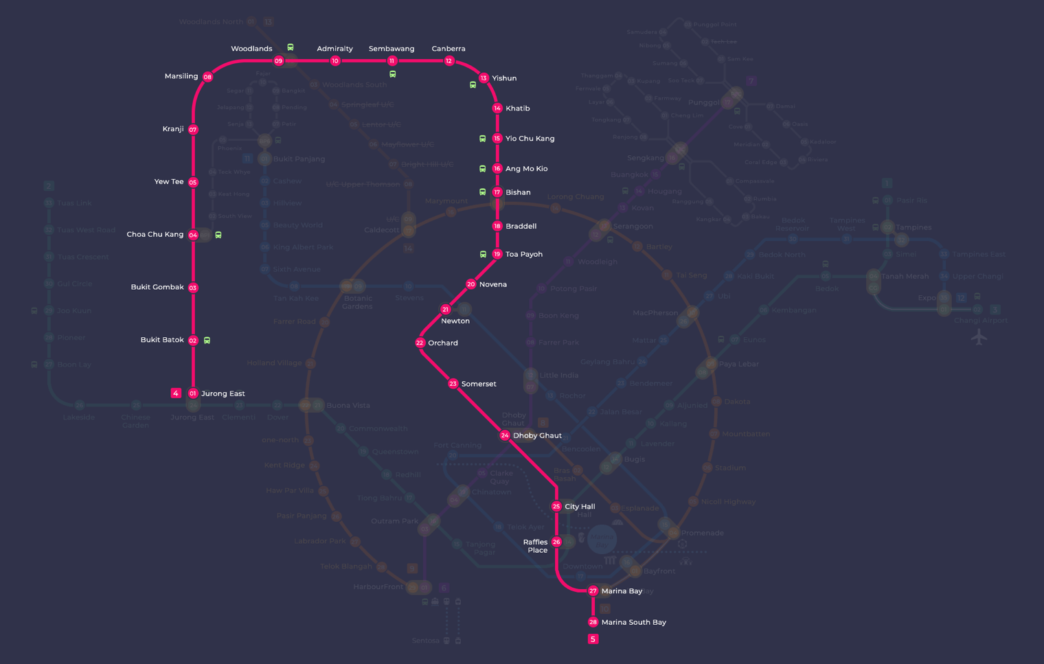
North-South Line map highlighted. For searching and highlighting MRT stations or lines on the map we recommend to use our interactive MRT map.
North South Line map: route and key facts
The North South Line (NSL) is the red line on the Singapore MRT map, with station codes starting with NS. It opened in 1987 as Singapore's first MRT line and runs in a long loop from Jurong East up through Woodlands, then south through Ang Mo Kio, Orchard and the city centre to Marina South Bay.
Welcome to my complete transit guide on the North-South Line MRT in Singapore. Altogether, the first MRT line in Singapore, the North-South Line, is of great historical importance and is also an important transportation artery. For residents or foreign travellers, this guide covers the necessary information on how to opt for North-South line transit with ease or effectiveness.
Key Points:
The North South Line (NSL) was Singapore’s first MRT line, opening in 1987.
It connects major residential towns in the north and west to the city centre, passing through key stops like Orchard, City Hall and Raffles Place.
Use the route map on this page to follow the line and plan your journey before you travel.
You can pay your fare with an EZ-Link or SimplyGo card, a contactless bank card, or a mobile wallet. Visitors can also use the Singapore Tourist Pass.
The History and Significance of the North South Line
The North South Line holds a special place in Singapore’s transport story. It was the country’s first MRT line, and its opening in 1987 marked a turning point in how Singaporeans move around the city.
Construction was a major undertaking, cutting through a dense urban area to connect residential towns with commercial centres. The line runs about 45 kilometres and serves both everyday commuters and visitors travelling to key destinations across the island.
Over the decades, the North South Line has gone through several expansions and upgrades. These improvements have kept it relevant as Singapore’s population and built-up areas have grown, and today it remains one of the busiest lines on the network.
As the first MRT line to serve Singapore, the North South Line laid the foundation for everything that followed. The ticketing systems, platform screen doors and passenger announcements that feel routine today all have roots in the early lessons learned on this line.
In the sections below, we look at how the line was built, the milestones it has reached, and the role it continues to play in Singapore’s rail network.
Milestones of the North South Line
Year
Milestone
1987
The first phase of the segment from Yio Chu Kang to Toa Payoh is about to start.
1988
It’s being extended to Marina Bay.
1990
Now, the line from Marina Bay to Jurong East has been completed.
1996
Extensions could take Choa Chu Kang in, too.
2014
At the bottom of the Downtown Line, there is an interchange at Newton.
2017
Tuas West Extension has been completed, and it interconnects with Tuas Link.
The North South Line passes through a wide range of destinations, from residential towns to city-centre landmarks. Whether you are heading to a park, a shopping belt or a heritage area, there is likely a station that gets you close.
Botanic Gardens station puts you right at the entrance to Singapore’s only UNESCO World Heritage Site. The gardens are a calm, green escape from the city and well worth a visit on their own. Stroll through the themed gardens, see the National Orchid Garden, or sit by Swan Lake for a while.
Station
Attractions
Orchard
Orchard Road: A Shoppers Sanctuary in the World
Marina Bay
Unbelievable pool, Marina Bay Sands and Gardens by the malevolent recycler View Adapter
Raffles Place
Iconic attractions like Raffles Hotel and Merlion Park, as well as lively riverside dining.
Chinatown
Heritage streets, old shophouses, and lip-smacking local eats
Other useful stops along the line include Orchard, Marina Bay, Raffles Place and Chinatown. Each area has its own character and plenty to keep you occupied, so it is easy to build a full day around the line.
Singapore Botanic Gardens
The Singapore Botanic Gardens covers 82 hectares in the middle of the city and has been a public green space since 1859. It began as a colonial garden with a focus on economic crops, most notably rubber, which shaped the regional economy significantly. Over time it grew into a place that combines scientific research, conservation and public recreation. In 2015, UNESCO recognised it as a World Heritage Site, the only one in Singapore.
The gardens expanded gradually under colonial administration, with an early emphasis on cultivating agricultural plants giving them real economic importance across Southeast Asia. Today the focus has shifted to plant conservation and public enjoyment, with collections ranging from rainforest trees to carefully curated orchid hybrids. The UNESCO listing in 2015 confirmed the gardens’ lasting historical and cultural significance.
Location and Accessibility
Singapore Botanic Gardens is at 1 Cluny Road. The nearest MRT station is Botanic Gardens, which sits right next to the gardens. Several bus routes also serve the area if you are coming from nearby neighbourhoods.
Main Attractions
The Singapore Botanic Gardens has several popular attractions worth exploring:
National Orchid Garden
This garden holds more than 1,000 species and 2,000 hybrids of orchids, making it one of the largest collections in the world.
Evolution Garden
The Evolution Garden takes you through the history of plant life on Earth, tracing hundreds of millions of years of change in a single walk.
Rainforest
This patch of primary rainforest gives you a sense of what Singapore’s original vegetation looked like before development. It is one of the few remaining examples in the city.
Ginger Garden
Dedicated to the ginger family, this garden features a waterfall alongside a wide variety of gingers and related plants.
Jacob Ballas Children’s Garden
Designed for children, this garden includes a mini waterfall, a farm area, treehouses and other hands-on educational features.
Explore the North South Line
Once you know the route and where the transfer stations are, planning a journey on the North South Line is straightforward. Knowing the layout saves time, whether you are travelling end to end or just a few stops.
North South Line Route
The North South Line runs about 45 kilometres, linking the north of Singapore to the south. It starts at Jurong East in the west, passes through major areas including Orchard, City Hall and Marina Centre, and terminates at Marina South Pier.
The line has 27 stations and connects directly to many of Singapore’s key destinations. For residents in the north and west, it is often the quickest way into the city centre.
North South Line Map
North-South Line Map
The map below shows all stations, interchanges and connections on the North South Line. Use it to find the stations closest to your destination and work out the best place to change lines.
You can follow your journey through central Singapore on the map and spot where the North South Line crosses other lines, which makes planning transfers much simpler.
Timetables and Frequency on the North South Line
The table below gives first and last train times for stations on the North South Line. Check these before you travel, as times can vary by station and direction.
Station
First Train Departure
Last Train Departure
Marina Bay
5:33 AM
10:47 PM
Orchard
5:48 AM
11:05 PM
Ang Mo Kio
5:36 AM
11:06 PM
Times are subject to change, so it is worth checking the official SMRT website or app for the latest updates before you head out.
During peak hours, trains run roughly every 3 to 5 minutes. Off-peak, you can expect a slightly longer gap between services.
If there are delays, announcements will be made over the intercom at stations and on the trains. You can also check the SMRT app or the station display boards for real-time service updates.
Fare Structure and Payment Options
Fares on the North South Line are distance-based, so the further you travel, the more you pay. For the current fare tables, check the official Land Transport Authority or TransitLink websites, as amounts are reviewed periodically.
Fare Structure
You pay according to the distance between your boarding and alighting stations. Fares are calculated automatically when you tap in and tap out, so there is nothing to work out yourself.
You can pay with a contactless bank card, a mobile wallet, or an EZ-Link and SimplyGo card. If you are visiting Singapore, the Singapore Tourist Pass gives you unlimited rides for a set number of days and can be a practical option depending on how much you plan to travel.
Payment Options
There are several ways to pay for your trip on the North South Line.
EZ-Link or SimplyGo card: Tap your card on the reader at the fare gates as you enter and exit. You can top up at station add-value machines and many convenience stores.
Contactless bank card or mobile wallet: Any contactless debit or credit card, or a mobile wallet such as Apple Pay or Google Pay, works in the same way. Just tap in and tap out at the gates.
Singapore Tourist Pass: Visitors can buy this pass for unlimited travel on the MRT and buses for a set number of consecutive days. It covers the whole network, not just the North South Line.
Single-trip tickets: If you only need one journey, you can buy a ticket from the machines in any MRT station. Select your destination and the machine calculates the fare.
For current fare details, check the TransitLink website or the SimplyGo app.
Dealing with Disruptions on the North South Line
Disruptions happen on any rail line, and the North South Line is no exception. Knowing what to do in advance makes a real difference to your journey.
Follow these steps when things go wrong:
Check service advisories: SMRT posts real-time updates on their website and social media when there are delays or disruptions on the North South Line. Checking these before you leave, or as soon as you notice something is wrong, saves you time on the platform.
Use bus bridging services: When there is a significant disruption, SMRT typically deploys bus bridging services between affected stations. Station staff and in-station announcements will guide you to the right boarding point.
Consider other transport options: If the disruption looks set to last, buses, taxis and ride-hailing apps are all practical alternatives. Singapore’s bus network is extensive, and many routes run parallel to the North South Line corridor.
Disruptions are always temporary, and staying informed is the best way to keep your journey moving with the least fuss.
North South Line Extension
The North South Line has grown over the years, adding stations that open up residential towns, parks and local food across the island. You can read more about the full MRT lines in Singapore to see how the network fits together.
Stations along the Woodlands corridor and around Bukit Gombak give you access to a mix of housing estates, green spaces and hawker food. These areas are well worth a visit if you have not explored them before.
Near Bukit Gombak, Little Guilin and Bukit Batok Nature Park are popular for a walk or some fresh air. Both are easy to reach on foot from the station and make a good break from the city centre.
Woodlands has Woodlands Waterfront Park, where you can look out across the Johor Strait, and Admiralty Park, which has plenty of green space and is free to enter. The town centre around Woodlands MRT has a solid range of food options and everyday shops.
Around many of these stations you will find coffee shops, hawker centres and neighbourhood malls that give you a feel for everyday life in these parts of Singapore. It is a straightforward way to eat well and get a little off the beaten track without travelling far.
North South Line Extension Stations
Station Name
Interchange
Bukit Gombak
None
Woodlands
Woodlands North (upcoming)
The extended North South Line gives you a practical way to reach the northern and western parts of Singapore. From Bukit Gombak to Woodlands and beyond, the line takes you directly without needing to transfer.
North South Line as a Major Commuter Route
The North South Line is one of Singapore’s busiest MRT lines, running from Jurong East in the west across to the city centre and up through the heartlands to Woodlands and Sembawang in the north. It connects major residential towns, office districts and tourist areas in a single corridor, which makes it genuinely useful for most trips across the island.
Trains run frequently throughout the day, with very short gaps between services during peak hours. You generally do not need to check a timetable: just turn up and a train will arrive shortly. During off-peak hours, the frequency is lower but still reliable enough for most journeys.
The line is operated by SMRT and carries a large volume of passengers daily, serving everyone from office commuters heading into the CBD to residents travelling between the northern towns and the city.
North South Line Commuter Statistics
Key Statistics
Figures
Length of Line
Approximately 45 kilometres
Number of Stations
30 stations
Daily Ridership
Over 1 million passengers
Peak Hour Frequency
Approximately 2 to 3 minutes
Operating Hours
From early morning until midnight
These figures reflect how central the North South Line is to Singapore’s public transport network. For many commuters in the northern and central parts of the island, it is the first or last leg of almost every journey.
Exploring Beyond the North South Line
The North South Line connects well with the rest of Singapore’s MRT network, making it straightforward to reach most parts of the island by combining lines. At interchange stations, you simply walk to the platform for your next line without tapping out and back in again.
Connecting Lines
Several interchange stations along the North South Line let you transfer directly to other lines. Singapore’s MRT network is designed so that transfers are quick and clearly signposted, usually just a short walk along a covered corridor.
MRT Line
Interchange Station
East West Line
Jurong East
Circle Line
HarbourFront
Downtown Line
Chinatown
These interchanges mean you can reach a wide range of destinations without needing to take a bus or taxi. For example, you can change to the Circle Line at Dhoby Ghaut or Bishan, or switch to the East West Line at Jurong East or City Hall, depending on where you are headed.
Bus Services
The MRT gets you most of the way, but buses cover the gaps for destinations not on any rail line. Most NSL stations have bus connections to nearby neighbourhoods, and you can plan your journey using the TransitLink website or the MyTransport.SG app.
Specific bus numbers and routes do change, so treat any list as a starting point only. Check the TransitLink journey planner for current routes, stop locations and frequencies before you head out.
Combining the NSL with other MRT lines and bus services gives you straightforward access to most parts of Singapore. The system maps on this site and the TransitLink planner are good starting points when putting together your route.
Conclusion
The North South Line covers a lot of ground, linking the northern towns to the city centre and on towards the south, with plenty of history, food and green space along the way. It is one of the most useful lines on the network, whether you are commuting or exploring.
Check the full station list, route map and fare information before you travel so you know exactly where to board and alight. Pairing the NSL with connections to other lines opens up almost every corner of Singapore.
Keep an eye on service notices from SMRT, especially during peak hours or public holidays, as engineering works or short-working trains can affect which stations are served. A little planning goes a long way.
Station guides on this line
Codes, transfers, next stations, train times and a map link for each station.
The North South Line is operated by SMRT. SMRT also runs the East West Line, Circle Line, Thomson-East Coast Line and Bukit Panjang LRT.
How many stations does the North South Line have?
The North South Line has 27 stations, running from Jurong East in the west to Marina South Pier in the south. Station codes run from NS1 to NS28, with some numbers in that range not in use on the line.
Can I use a contactless bank card on the North South Line?
Yes, you can tap in and out with a contactless bank card, a mobile wallet, or an EZ-Link or SimplyGo card. If you are visiting Singapore, the Singapore Tourist Pass is another option worth considering.
What colour is the North South Line on the MRT map?
The North South Line is shown in red on the Singapore MRT map, and all its stations carry the NS prefix. This makes it easy to spot when you are planning a journey or checking a transfer.
Does the North South Line connect to the Thomson-East Coast Line?
Yes, you can change between the North South Line and the Thomson-East Coast Line at Woodlands station, which is coded NS9 on the red line and TE2 on the brown line. This interchange is particularly useful for travel to and from the north of Singapore.

Want the whole route on one page? Open the North South Line map to see every station and interchange along the line.