
Punggol MRT Station
Punggol MRT station is an interchange station serving the North East Line, where it carries the station code NE17, and the Punggol LRT, where it is identified by the code PTC. It sits at the northern end of the North East Line and acts as the central point of the Punggol LRT network. The station serves Punggol, a large residential town in the north-east of Singapore that has seen considerable housing development in recent years and is home to a growing population of families and young residents.
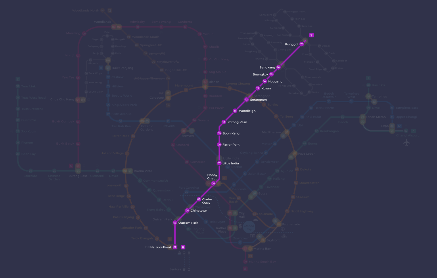
Punggol on the North East Line map
Punggol MRT station at a glance
| Station codes | NE17PTC |
|---|---|
| Lines | North East Line Punggol LRT |
| Line colour | Purple line (North East Line) Grey line (Punggol LRT) |
| Interchange | Yes, change between 2 lines here |
| Chinese name | 榜鹅 |
| Tamil name | பொங்கோல் |
| Next stations | |
| Train times | North East Line: first train leaves the terminus at 5:39 AM, last train 11:55 PM Full first and last train guide |
See Punggol on the map. The interactive map opens with this station highlighted, so you can trace the route from where you are.
Travellers using the North East Line can reach the city centre directly from here, passing through Sengkang, the only neighbouring station on that line, before continuing south towards Dhoby Ghaut and HarbourFront. At Sengkang, passengers can also change onto the Sengkang LRT. From Punggol station itself, the Punggol LRT branches out in two loops covering the surrounding residential estates, making this station the natural starting point for journeys deeper into the Punggol district.
The immediate area around the station is primarily residential, with a concentration of Housing Development Board flats and neighbourhood amenities close by. Waterway Point, a shopping mall built alongside the station, is directly accessible and contains a wide range of retail, dining and supermarket options. Beyond the mall, the Punggol Waterway and its adjoining park connector are within easy walking distance, offering a popular outdoor space for residents and visitors alike.
Around Punggol MRT station
Punggol station sits at the heart of a large planned residential new town in the north-east of Singapore, with a significant retail and transport hub immediately surrounding it. Waterway Point shopping mall and Punggol Bus Interchange are both within a couple of minutes of the station, making the area a busy local centre. Further afield, Punggol Waterway Park adds a natural, recreational dimension to the neighbourhood.
| Place | Type | Distance | Why go |
|---|---|---|---|
| Waterway Point | Shopping mall | About 140 m (~2 min walk) | Visit Waterway Point for shopping, dining and everyday errands in one large mall. |
| Punggol Bus Interchange | Bus interchange | About 140 m (~2 min walk) | Use Punggol Bus Interchange to connect to bus services across the north-east. |
| Encik Tan | Food centre | About 160 m (~3 min walk) | Head to Encik Tan for a casual meal at a local food centre. |
| NTWU Canteen | Food centre | About 160 m (~3 min walk) | Try NTWU Canteen for affordable, everyday food centre dining options. |
| Cookhouse | Food centre | About 190 m (~3 min walk) | Visit Cookhouse for another nearby food centre serving a range of local meals. |
| Punggol Gems Residents' Network | Community club | About 300 m (~5 min walk) | Drop by Punggol Gems Residents' Network for community activities and local events. |
| Punggol Waterway Park | Park | About 540 m (~9 min walk) | Walk to Punggol Waterway Park for outdoor recreation along the waterway. |
| Splash @ Kidz Amaze | Water park | About 690 m (~11 min walk) | Bring the family to Splash @ Kidz Amaze for water-based play and activities. |
Places and straight-line distances from OpenStreetMap data (© OpenStreetMap contributors). Actual walking routes may be longer.
How to get to Punggol by MRT
Worked out from the network map. Stop counts are station to station and do not include walking or waiting time.
| From Changi Airport | Take the East West Line from Changi Airport to Paya Lebar (6 stops), then change to the Circle Line from Paya Lebar to Serangoon (4 stops), then change to the North East Line from Serangoon to Punggol (5 stops). About 15 stops with 2 changes. |
|---|---|
| From Orchard | Take the North South Line from Orchard to Dhoby Ghaut (2 stops), then change to the North East Line from Dhoby Ghaut to Punggol (11 stops). About 13 stops with 1 change. |
| From City Hall | Take the North South Line from City Hall to Dhoby Ghaut (1 stop), then change to the North East Line from Dhoby Ghaut to Punggol (11 stops). About 12 stops with 1 change. |
| From Jurong East | Take the East West Line from Jurong East to Buona Vista (3 stops), then change to the Circle Line from Buona Vista to Serangoon (8 stops), then change to the North East Line from Serangoon to Punggol (5 stops). About 16 stops with 2 changes. |
| From Woodlands | Take the North South Line from Woodlands to Bishan (8 stops), then change to the Circle Line from Bishan to Serangoon (2 stops), then change to the North East Line from Serangoon to Punggol (5 stops). About 15 stops with 2 changes. |
| From HarbourFront | Take the North East Line from HarbourFront to Punggol (15 stops). About 15 stops, no changes. |
Fares from Punggol MRT station
A trip from Punggol to Changi Airport (about 26 km) costs S$2.42 on an adult SimplyGo or EZ-Link card. Fares are charged by distance, so the table below shows the estimated adult card fare from Punggol to the main hubs, the early bird fare for journeys that start before 7.45am on weekdays, and the fare that applies from 26 December 2026.
| To | Distance | Adult card | Before 7.45am | From 26 Dec 2026 |
|---|---|---|---|---|
| Changi Airport | about 26 km, 15 stops | S$2.42 | S$1.92 | S$2.55 |
| Orchard | about 17 km, 13 stops | S$2.15 | S$1.65 | S$2.28 |
| City Hall | about 16 km, 12 stops | S$2.15 | S$1.65 | S$2.28 |
| Raffles Place | about 17 km, 13 stops | S$2.20 | S$1.70 | S$2.33 |
| Jurong East | about 27 km, 16 stops | S$2.44 | S$1.94 | S$2.57 |
| Woodlands | about 28 km, 15 stops | S$2.45 | S$1.95 | S$2.58 |
| HarbourFront | about 21 km, 15 stops | S$2.30 | S$1.80 | S$2.43 |
| Marina Bay | about 20 km, 17 stops | S$2.27 | S$1.77 | S$2.40 |
Estimated from the route distance between stations and the Public Transport Council fare table in force from 27 December 2025. The exact fare can differ by one band. Cash fares are higher. Use the fare calculator for any other journey, or check your fare on the SimplyGo app.
Tips for using Punggol MRT station
- Waterway Point, Punggol Bus Interchange and the three nearby food centres are all within a short walk of the station, so there is no need for additional transport to reach them.
- Punggol is the terminal station on the North East Line and also serves as the hub for the Punggol LRT network, so allow extra time when transferring between lines during peak hours as platforms can get crowded.
- For Punggol Waterway Park and Splash @ Kidz Amaze, both are further away and involve a longer walk, so consider using the Punggol LRT or a bus from Punggol Bus Interchange to get closer before walking the remaining distance.
- As this is a terminal station, trains on the North East Line begin and end their journeys here, which can mean heavier passenger volumes in the mornings and evenings on weekdays.
All stations on the North East Line
In order along the line, with Punggol marked. Stations with their own guide are linked.
| Code | Station | Interchange |
|---|---|---|
| NE1 | HarbourFront | CC / NE |
| NE3 | Outram Park | TE / EW / NE |
| NE4 | Chinatown | DT / NE |
| NE5 | Clarke Quay | None |
| NE6 | Dhoby Ghaut | NS / NE / CC |
| NE7 | Little India | DT / NE |
| NE8 | Farrer Park | None |
| NE9 | Boon Keng | None |
| NE10 | Potong Pasir | None |
| NE11 | Woodleigh | None |
| NE12 | Serangoon | CC / NE |
| NE13 | Kovan | None |
| NE14 | Hougang | None |
| NE15 | Buangkok | None |
| NE16 | Sengkang | NE / STC |
| NE17 | Punggol (you are here) | NE / PTC |
| NE18 | Punggol Coast | None |
Read the full North East Line guide.
Punggol MRT station: common questions
Which line is Punggol MRT station on?
Punggol is on the North East Line and the Punggol LRT. Its station codes are NE17 and PTC.
Is Punggol an interchange station?
Yes. You can change between the North East Line and the Punggol LRT inside the station without leaving the paid area.
What time is the first and last train at Punggol?
Times below are for the first and last train leaving the line terminus; trains reach Punggol a few minutes later depending on its position on the line. North East Line first train 5:39 AM, last train 11:55 PM. Check the operator for holiday changes.
What is near Punggol MRT station?
Punggol station is surrounded by several useful destinations, including Waterway Point shopping mall and Punggol Bus Interchange at approximately 140 metres away, three food centres within about 190 metres, and Punggol Waterway Park at roughly 540 metres.
Which shopping mall is closest to Punggol MRT station?
Waterway Point is the closest shopping mall, at approximately 140 metres from the station, which is roughly a 2-minute walk.
How far is Punggol Waterway Park from Punggol MRT station?
Punggol Waterway Park is approximately 540 metres from the station in a straight line, which is roughly a 9-minute walk.
How do I get to Punggol from Changi Airport by MRT?
Take the East West Line from Changi Airport to Paya Lebar (6 stops), then change to the Circle Line from Paya Lebar to Serangoon (4 stops), then change to the North East Line from Serangoon to Punggol (5 stops). About 15 stops with 2 changes.
Sources: station codes, line colours and interchanges from the LTA rail system map; operating hours from SMRT and SBS Transit. Last reviewed September 2026.
News and guides mentioning Punggol
- Chain collision of 3 buses in Yishun injures 5 riders 16 Oct 2026
- Singapore MRT line colours: every line by colour 6 Oct 2026
- Sengkang West LRT Reopens Oct 4: What Riders Need to Know 5 Oct 2026
- Singapore MRT Glossary: Every Term on the Map Explained 5 Oct 2026
Plan the rest of the trip
Every station on the North East Line and the Punggol LRT is listed on its line guide, with the full route and interchanges. For times, see the first and last train guide, and for the whole network in one view use the interactive Singapore MRT map or the PDF map.