
Jurong East MRT Station
Jurong East MRT station is an elevated interchange on Jurong Gateway Road in Jurong East, in the west of Singapore. It serves two lines: the East West Line, where its code is EW24, and the North South Line, where it carries the code NS1 and North South Line trains start and finish their runs. SMRT Trains operates the station, and its platforms sit above street level on the viaduct.
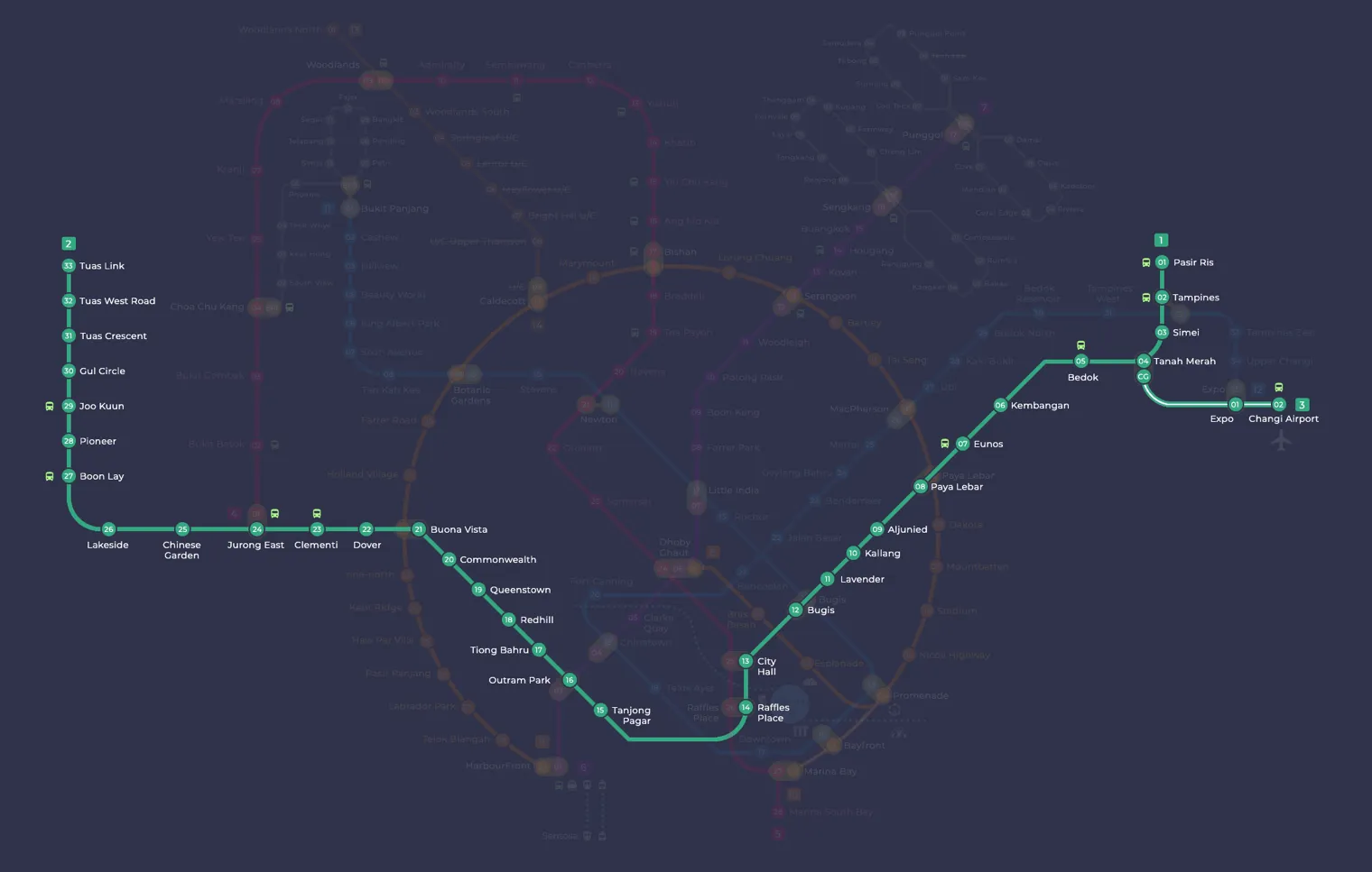
Jurong East on the East West Line map
Jurong East MRT station at a glance
| Station codes | EW24NS1 |
|---|---|
| Lines | East West Line North South Line |
| Line colour | Green line (East West Line) Red line (North South Line) |
| Interchange | Yes, change between 2 lines here |
| Chinese name | 裕廊东 |
| Tamil name | ஜூரோங் கிழக்கு |
| Opened | 5 November 1988 (38 years ago) |
| Operator | SMRT Trains |
| Station type | Elevated |
| Platforms | 6 (3 island platforms) |
| Address | 10 Jurong East Street 12, Singapore 609690 |
| Daily ridership | About 64,034 passengers a day (2024) |
| Next stations | |
| Train times | East West Line: first train leaves the terminus at 5:19 AM, last train 11:23 PM North South Line: first train leaves the terminus at 5:16 AM, last train 11:48 PM Full first and last train guide |
Opening date, operator and ridership figures are LTA data as recorded on Wikipedia.
See Jurong East on the map. The interactive map opens with this station highlighted, so you can trace the route from where you are.
Many passengers come here to change between the two lines, and the station is one of the main transport points in the west. Others are heading to the shopping malls around Jurong Gateway, including Jem, Westgate and IMM, or visiting Ng Teng Fong General Hospital. It also links with bus services at the Jurong East Bus Interchange and the Jurong Town Hall Bus Interchange. The station is planned to become an interchange with the Jurong Region Line when that line’s second stage opens, expected in 2028, and to form part of the Jurong East Integrated Transport Hub, a complex combining civic, retail and commercial space.
History of Jurong East MRT station
The station opened on 5 November 1988, when the line was extended westward to Lakeside. During planning it was called Jurong Town, then simply Jurong, before taking its current name in March 1987. From 10 March 1990 it was the end point of the Branch line to Choa Chu Kang, a route that became part of the North South Line in February 1996. In the late 1980s, a government minister even suggested opening discos inside the station to bring more life to it.
Inside Jurong East MRT station
An additional platform and track opened in May 2011 so that North South Line trains could run more often, at first only during weekday peak hours. The station was among the first in Singapore to receive half-height platform screen doors, fitted during a pilot in 2009, and high-volume low-speed fans were added between 2012 and 2013.
For a quick meal, Kopitiam is about a minute’s walk away and Food Junction about two minutes, while Westgate is close enough for shopping or errands straight off the train. Residents often use the station to reach Jurong Regional Library, around five minutes on foot, or Ng Teng Fong General Hospital, about six minutes away. Families on a day out can walk to Science Centre Singapore in roughly 11 minutes, which makes Jurong East MRT station a practical starting point for exploring this part of the west.
Around Jurong East MRT station
Jurong East station sits at the heart of one of Singapore's major regional commercial hubs, surrounded by shopping malls, food centres and medical facilities. The area draws visitors for retail and dining, with Westgate and Food Junction among the prominent destinations within a short walk. It also serves residents and patients heading to Ng Teng Fong General Hospital and Jurong Community Hospital nearby.
| Place | Type | Distance | Why go |
|---|---|---|---|
| Kopitiam | Food centre | About 30 m (~1 min walk) | A convenient spot for quick local meals and coffee close to the station. |
| Food Junction | Food centre | About 130 m (~2 min walk) | A food court offering a wide variety of affordable cooked food options. |
| Westgate | Shopping mall | About 140 m (~2 min walk) | A large shopping mall with retail, dining and lifestyle offerings. |
| Jurong Regional Library | Library | About 310 m (~5 min walk) | A public library with reading materials, study spaces and community programmes. |
| Ng Teng Fong General Hospital | Hospital | About 360 m (~6 min walk) | A general hospital providing acute medical and surgical care. |
| Jurong Community Hospital | Hospital | About 480 m (~8 min walk) | A community hospital offering step-down and rehabilitative care services. |
| Certis Cisco west hub | Attraction | About 500 m (~8 min walk) | A security and investigations hub for the Certis Cisco organisation. |
| Science Centre Singapore | Museum | About 690 m (~11 min walk) | A science museum with interactive exhibits suitable for families and students. |
Places and straight-line distances from OpenStreetMap data (© OpenStreetMap contributors). Actual walking routes may be longer.
How to get to Jurong East by MRT
Worked out from the network map. Stop counts are station to station and do not include walking or waiting time.
| From Changi Airport | Take the East West Line from Changi Airport to Jurong East (22 stops). About 22 stops, no changes. |
|---|---|
| From Orchard | Take the Thomson East Coast Line from Orchard to Outram Park (3 stops), then change to the East West Line from Outram Park to Jurong East (8 stops). About 11 stops with 1 change. |
| From City Hall | Take the East West Line from City Hall to Jurong East (11 stops). About 11 stops, no changes. |
| From Woodlands | Take the North South Line from Woodlands to Jurong East (7 stops). About 7 stops, no changes. |
| From HarbourFront | Take the North East Line from HarbourFront to Outram Park (1 stop), then change to the East West Line from Outram Park to Jurong East (8 stops). About 9 stops with 1 change. |
Fares from Jurong East MRT station
A trip from Jurong East to Changi Airport (about 36 km) costs S$2.52 on an adult SimplyGo or EZ-Link card. Fares are charged by distance, so the table below shows the estimated adult card fare from Jurong East to the main hubs, the early bird fare for journeys that start before 7.45am on weekdays, and the fare that applies from 26 December 2026.
| To | Distance | Adult card | Before 7.45am | From 26 Dec 2026 |
|---|---|---|---|---|
| Changi Airport | about 36 km, 22 stops | S$2.52 | S$2.02 | S$2.65 |
| Orchard | about 17 km, 11 stops | S$2.15 | S$1.65 | S$2.28 |
| City Hall | about 17 km, 11 stops | S$2.15 | S$1.65 | S$2.28 |
| Raffles Place | about 16 km, 10 stops | S$2.11 | S$1.61 | S$2.24 |
| Woodlands | about 16 km, 7 stops | S$2.11 | S$1.61 | S$2.24 |
| HarbourFront | about 17 km, 9 stops | S$2.15 | S$1.65 | S$2.28 |
| Marina Bay | about 17 km, 11 stops | S$2.15 | S$1.65 | S$2.28 |
Estimated from the route distance between stations and the Public Transport Council fare table in force from 27 December 2025. The exact fare can differ by one band. Cash fares are higher. Use the fare calculator for any other journey, or check your fare on the SimplyGo app.
Tips for using Jurong East MRT station
- Jurong East is an interchange station between the East West Line and North South Line, so plan your onward journey in advance to choose the correct line.
- The nearest food centres and Westgate are within a couple of minutes on foot, making them easy stops before or after your train journey.
- For Ng Teng Fong General Hospital and Jurong Community Hospital, allow roughly 6 to 8 minutes of walking time, or consider a short taxi or ride-hailing trip if mobility is a concern.
- The Science Centre Singapore is about 11 minutes away on foot, so factor in extra time, particularly if travelling with children or during the midday heat.
All stations on the East West Line
In order along the line, with Jurong East marked. Stations with their own guide are linked.
| Code | Station | Interchange |
|---|---|---|
| EW1 | Pasir Ris | None |
| EW2 | Tampines | EW / DT |
| EW3 | Simei | None |
| EW4 | Tanah Merah | None |
| EW5 | Bedok | None |
| EW6 | Kembangan | None |
| EW7 | Eunos | None |
| EW8 | Paya Lebar | CC / EW |
| EW9 | Aljunied | None |
| EW10 | Kallang | None |
| EW11 | Lavender | None |
| EW12 | Bugis | DT / EW |
| EW13 | City Hall | EW / NS |
| EW14 | Raffles Place | NS / EW |
| EW15 | Tanjong Pagar | None |
| EW16 | Outram Park | TE / EW / NE |
| EW17 | Tiong Bahru | None |
| EW18 | Redhill | None |
| EW19 | Queenstown | None |
| EW20 | Commonwealth | None |
| EW21 | Buona Vista | EW / CC |
| EW22 | Dover | None |
| EW23 | Clementi | None |
| EW24 | Jurong East (you are here) | EW / NS |
| EW25 | Chinese Garden | None |
| EW26 | Lakeside | None |
| EW27 | Boon Lay | None |
| EW28 | Pioneer | None |
| EW29 | Joo Koon | None |
| EW30 | Gul Circle | None |
| EW31 | Tuas Crescent | None |
| EW32 | Tuas West Road | None |
| EW33 | Tuas Link | None |
Read the full East West Line guide.
All stations on the North South Line
In order along the line, with Jurong East marked. Stations with their own guide are linked.
| Code | Station | Interchange |
|---|---|---|
| NS1 | Jurong East (you are here) | EW / NS |
| NS2 | Bukit Batok | None |
| NS3 | Bukit Gombak | None |
| NS4 | Choa Chu Kang | NS / BP |
| NS5 | Yew Tee | None |
| NS7 | Kranji | None |
| NS8 | Marsiling | None |
| NS9 | Woodlands | NS / TE |
| NS10 | Admiralty | None |
| NS11 | Sembawang | None |
| NS12 | Canberra | None |
| NS13 | Yishun | None |
| NS14 | Khatib | None |
| NS15 | Yio Chu Kang | None |
| NS16 | Ang Mo Kio | None |
| NS17 | Bishan | NS / CC |
| NS18 | Braddell | None |
| NS19 | Toa Payoh | None |
| NS20 | Novena | None |
| NS21 | Newton | NS / DT |
| NS22 | Orchard | TE / NS |
| NS23 | Somerset | None |
| NS24 | Dhoby Ghaut | NS / NE / CC |
| NS25 | City Hall | EW / NS |
| NS26 | Raffles Place | NS / EW |
| NS27 | Marina Bay | CE / TE / NS |
| NS28 | Marina South Pier | None |
Read the full North South Line guide.
Jurong East MRT station: common questions
Which line is Jurong East MRT station on?
Jurong East is on the East West Line and the North South Line. Its station codes are EW24 and NS1.
Is Jurong East an interchange station?
Yes. You can change between the East West Line and the North South Line inside the station without leaving the paid area.
What time is the first and last train at Jurong East?
Times below are for the first and last train leaving the line terminus; trains reach Jurong East a few minutes later depending on its position on the line. East West Line first train 5:19 AM, last train 11:23 PM. North South Line first train 5:16 AM, last train 11:48 PM. Check the operator for holiday changes.
What is near Jurong East MRT station?
The area around Jurong East station includes food centres such as Kopitiam and Food Junction, Westgate shopping mall, Jurong Regional Library, Ng Teng Fong General Hospital, Jurong Community Hospital and Science Centre Singapore, all within approximately 700 metres.
Which mall or food centre is closest to Jurong East MRT station?
Kopitiam is the closest food centre at approximately 30 metres away, while Westgate and Food Junction are both around 130 to 140 metres away, making all three reachable in just a couple of minutes on foot.
How far is Science Centre Singapore from Jurong East MRT station?
Science Centre Singapore is approximately 690 metres from Jurong East station, which is roughly an 11-minute walk.
How do I get to Jurong East from Changi Airport by MRT?
Take the East West Line from Changi Airport to Jurong East (22 stops). About 22 stops, no changes.
Sources: station codes, line colours and interchanges from the LTA rail system map; operating hours from SMRT and SBS Transit. Last reviewed October 2026.
News and guides mentioning Jurong East
- Sketching on the MRT: What If Someone Draws Your Child? 6 Nov 2026
- N95 masks for rail and bus workers amid haze: where to get them 6 Nov 2026
- MRT floor sleeping: why commuters choose it over empty seats 6 Nov 2026
- Johor-Singapore RTS Link gets 5G: What it means for cross-border riders 6 Nov 2026
Plan the rest of the trip
Every station on the East West Line and the North South Line is listed on its line guide, with the full route and interchanges. For times, see the first and last train guide, and for the whole network in one view use the interactive Singapore MRT map or the PDF map.
Exits and buses at Jurong East station
Bus stops within 250 m of Jurong East station
| Bus stop | Stop code | Services | From station |
|---|---|---|---|
| Opposite The JTC Summit | 28201 | 990 | 119 m |
| Jurong East Interchange | 28009 | 41, 49, 51, 51A, 52, 66, 97, 97e, 98, 98M, 105, 105B, 143, 143M, 160, 160M, 183, 183B, 197, 333, 334, 335, 506, 993 | 168 m |
| Opposite JEM | 28199 | 333 | 184 m |
| Before Jurong East Station | 28211 | 41, 51, 52, 78, 98, 98M, 105, 143, 143M, 183, 334, 335, 990 | 202 m |
Exits and bus services come from OpenStreetMap and can change when roads or routes are revised; check the board at the stop or the operator app before relying on a service late at night. For the nearest station to where you are now, use the MRT near me finder.
Places to visit from Jurong East station
Step-by-step guides with the exit to use, the walk and the fare:
See every guide on how to get to Singapore's attractions, hospitals and malls by MRT, with routes and fares from Changi Airport, Orchard and the city.
MRT routes from Jurong East
Step-by-step directions with stops, changes, fare and time: Jurong East to Chinatown | Jurong East to Marina Bay | Jurong East to Tampines | Jurong East to Woodlands.
Routes to Jurong East: Bayfront to Jurong East | Bugis to Jurong East | Changi Airport to Jurong East | City Hall to Jurong East | HarbourFront to Jurong East | Orchard to Jurong East | Raffles Place to Jurong East.
More on the MRT routes hub.
Hungry? See food near Jurong East MRT: hawker centres, food courts and cafes with walking times.