
Kent Ridge MRT Station
Kent Ridge MRT station is a stop on the Circle Line, carrying the station code CC24. It serves a quiet academic and residential precinct in the south-western part of Singapore, close to the National University of Singapore campus and the surrounding Kent Ridge area. The station is not an interchange, but its position on the Circle Line makes it straightforward to reach many parts of the island without the need to change trains at this stop.
Kent Ridge on the Circle Line map
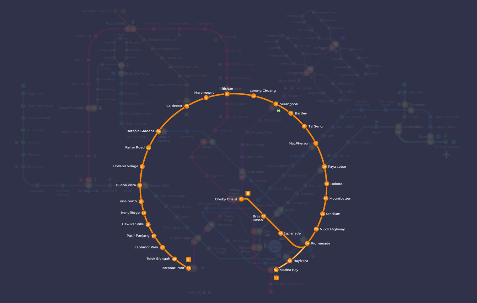
Kent Ridge MRT station at a glance
| Station codes | CC24 |
|---|---|
| Lines | Circle Line |
| Line colour | Yellow line (Circle Line) |
| Interchange | No, single line station |
| Chinese name | 肯特岗 |
| Tamil name | கெண்ட் ரிஜ் |
| Next stations | |
| Train times | Circle Line: first train leaves the terminus at 5:37 AM, last train 11:56 PM Full first and last train guide |
See Kent Ridge on the map. The interactive map opens with this station highlighted, so you can trace the route from where you are.
From Kent Ridge, the Circle Line runs directly to one-north station in one direction and Haw Par Villa station in the other. One-north is a key interchange-free stop serving the research and business district of the same name, while Haw Par Villa sits closer to the southern coastline. Travelling further along the Circle Line from either neighbouring station brings passengers to interchange points such as Buona Vista, where the East-West Line can be joined, expanding the range of destinations considerably.
The station sits close to the National University of Singapore, making it a practical starting point for anyone visiting the university's faculties, libraries, or public-facing facilities. The broader Kent Ridge neighbourhood is largely made up of educational institutions, green spaces, and low-density residential streets, so the area around the station is generally calm and walkable rather than heavily commercial.
Around Kent Ridge MRT station
Kent Ridge station sits within a largely academic and medical precinct in the western part of Singapore. The immediate surroundings are dominated by the National University Hospital and several university campuses, including the National University of Singapore. A handful of food centres serve the students, staff and visitors who make up most of the daytime foot traffic in this area.
| Place | Type | Distance | Why go |
|---|---|---|---|
| The Dining Avenue | Food centre | About 50 m (~1 min walk) | A food centre on the NUS campus offering a range of local meal options. |
| On The Ridge | Food centre | About 50 m (~1 min walk) | Another campus food centre catering to students and hospital visitors. |
| Juz Eat | Food centre | About 50 m (~1 min walk) | A food centre option close to the station for quick and casual meals. |
| National University Hospital | Hospital | About 160 m (~3 min walk) | A major public hospital serving patients and medical visitors in the area. |
| INSEAD Asia | University | About 730 m (~12 min walk) | A postgraduate business school campus for those attending courses or events. |
| Curtin Singapore | University | About 780 m (~13 min walk) | A private university campus for students and prospective applicants to visit. |
| National University of Singapore | University | About 840 m (~14 min walk) | The main campus of Singapore's largest university, worth exploring on foot. |
| Haw Par Villa | Attraction | About 1070 m (~17 min walk) | A cultural heritage attraction featuring mythological dioramas set in landscaped grounds. |
Places and straight-line distances from OpenStreetMap data (© OpenStreetMap contributors). Actual walking routes may be longer.
How to get to Kent Ridge by MRT
Worked out from the network map. Stop counts are station to station and do not include walking or waiting time.
| From Changi Airport | Take the East West Line from Changi Airport to Paya Lebar (6 stops), then change to the Circle Line from Paya Lebar to Kent Ridge (14 stops). About 20 stops with 1 change. |
|---|---|
| From Orchard | Take the Thomson East Coast Line from Orchard to Caldecott (4 stops), then change to the Circle Line from Caldecott to Kent Ridge (6 stops). About 10 stops with 1 change. |
| From City Hall | Take the East West Line from City Hall to Buona Vista (8 stops), then change to the Circle Line from Buona Vista to Kent Ridge (2 stops). About 10 stops with 1 change. |
| From Jurong East | Take the East West Line from Jurong East to Buona Vista (3 stops), then change to the Circle Line from Buona Vista to Kent Ridge (2 stops). About 5 stops with 1 change. |
| From Woodlands | Take the Thomson East Coast Line from Woodlands to Caldecott (7 stops), then change to the Circle Line from Caldecott to Kent Ridge (6 stops). About 13 stops with 1 change. |
| From HarbourFront | Take the Circle Line from HarbourFront to Kent Ridge (5 stops). About 5 stops, no changes. |
Fares from Kent Ridge MRT station
A trip from Kent Ridge to Changi Airport (about 32 km) costs S$2.49 on an adult SimplyGo or EZ-Link card. Fares are charged by distance, so the table below shows the estimated adult card fare from Kent Ridge to the main hubs, the early bird fare for journeys that start before 7.45am on weekdays, and the fare that applies from 26 December 2026.
| To | Distance | Adult card | Before 7.45am | From 26 Dec 2026 |
|---|---|---|---|---|
| Changi Airport | about 32 km, 20 stops | S$2.49 | S$1.99 | S$2.62 |
| Orchard | about 15 km, 10 stops | S$2.07 | S$1.57 | S$2.20 |
| City Hall | about 12 km, 10 stops | S$1.94 | S$1.44 | S$2.07 |
| Raffles Place | about 11 km, 9 stops | S$1.90 | S$1.40 | S$2.03 |
| Jurong East | about 8 km, 5 stops | S$1.82 | S$1.32 | S$1.95 |
| Woodlands | about 24 km, 13 stops | S$2.38 | S$1.88 | S$2.51 |
| HarbourFront | about 7 km, 5 stops | S$1.68 | S$1.18 | S$1.81 |
| Marina Bay | about 11 km, 9 stops | S$1.90 | S$1.40 | S$2.03 |
Estimated from the route distance between stations and the Public Transport Council fare table in force from 27 December 2025. The exact fare can differ by one band. Cash fares are higher. Use the fare calculator for any other journey, or check your fare on the SimplyGo app.
Tips for using Kent Ridge MRT station
- The three food centres and the National University Hospital are all within a short walk of the station, making them easy to reach on foot.
- National University of Singapore and the two other university campuses are a considerable walk away, so allow extra time or consider taking a bus from near the station to reach them more comfortably.
- Haw Par Villa is roughly 17 minutes on foot from the station, so visitors may prefer to use public bus services rather than walking, particularly in hot or wet weather.
- The area can be busy on weekday mornings and lunchtimes due to hospital appointments and university activity, so allow a little extra time when travelling during those periods.
All stations on the Circle Line
In order along the line, with Kent Ridge marked. Stations with their own guide are linked.
| Code | Station | Interchange |
|---|---|---|
| CC1 | Dhoby Ghaut | NS / NE / CC |
| CC2 | Bras Basah | None |
| CC3 | Esplanade | None |
| CC4 | Promenade | CC / DT |
| CC5 | Nicoll Highway | None |
| CC6 | Stadium | None |
| CC7 | Mountbatten | None |
| CC8 | Dakota | None |
| CC9 | Paya Lebar | CC / EW |
| CC10 | MacPherson | CC / DT |
| CC11 | Tai Seng | None |
| CC12 | Bartley | None |
| CC13 | Serangoon | CC / NE |
| CC14 | Lorong Chuan | None |
| CC15 | Bishan | NS / CC |
| CC16 | Marymount | None |
| CC17 | Caldecott | CC / TE |
| CC19 | Botanic Gardens | DT / CC |
| CC20 | Farrer Road | None |
| CC21 | Holland Village | None |
| CC22 | Buona Vista | EW / CC |
| CC23 | one-north | None |
| CC24 | Kent Ridge (you are here) | None |
| CC25 | Haw Par Villa | None |
| CC26 | Pasir Panjang | None |
| CC27 | Labrador Park | None |
| CC28 | Telok Blangah | None |
| CC29 | HarbourFront | CC / NE |
| CC30 | Keppel | None |
| CC31 | Cantonment | None |
| CC32 | Prince Edward Road | None |
Read the full Circle Line guide.
Kent Ridge MRT station: common questions
Which line is Kent Ridge MRT station on?
Kent Ridge is on the Circle Line. Its station code is CC24.
Is Kent Ridge an interchange station?
No. Kent Ridge is served by the Circle Line only. The nearest interchange is shown in the next stations row above.
What time is the first and last train at Kent Ridge?
Times below are for the first and last train leaving the line terminus; trains reach Kent Ridge a few minutes later depending on its position on the line. Circle Line first train 5:37 AM, last train 11:56 PM. Check the operator for holiday changes.
What is near Kent Ridge MRT station?
The station is close to several food centres including The Dining Avenue, On The Ridge and Juz Eat, as well as the National University Hospital at approximately 160 metres away. Further afield, the National University of Singapore and Haw Par Villa are also reachable from this station.
Which food centre is closest to Kent Ridge MRT station?
The Dining Avenue, On The Ridge and Juz Eat are all approximately 50 metres from the station, making them the nearest food options and roughly a one-minute walk away.
How far is Haw Par Villa from Kent Ridge MRT station?
Haw Par Villa is approximately 1,070 metres from Kent Ridge station, which is roughly a 17-minute walk. Visitors may prefer to use a bus to get there more quickly.
How do I get to Kent Ridge from Changi Airport by MRT?
Take the East West Line from Changi Airport to Paya Lebar (6 stops), then change to the Circle Line from Paya Lebar to Kent Ridge (14 stops). About 20 stops with 1 change.
Sources: station codes, line colours and interchanges from the LTA rail system map; operating hours from SMRT and SBS Transit. Last reviewed September 2026.
Plan the rest of the trip
Every station on the Circle Line is listed on its line guide, with the full route and interchanges. For times, see the first and last train guide, and for the whole network in one view use the interactive Singapore MRT map or the PDF map.