
Kranji MRT Station
Kranji MRT station is an elevated stop on the North South Line, station code NS7, located along Woodlands Road in Sungei Kadut in the north of Singapore. It sits between the industrial land of Sungei Kadut and the Woodlands area and is run by SMRT Trains.
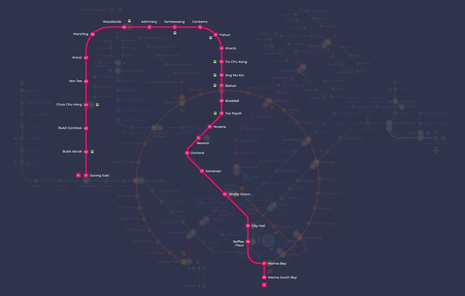
Kranji on the North South Line map
Kranji MRT station at a glance
| Station codes | NS7 |
|---|---|
| Lines | North South Line |
| Line colour | Red line (North South Line) |
| Interchange | No, single line station |
| Chinese name | 克兰芝 |
| Tamil name | கிராஞ்சி |
| Opened | 10 February 1996 (30 years ago) |
| Operator | SMRT Trains |
| Station type | Elevated |
| Platforms | 2 (1 island platform) |
| Address | 960 Woodlands RoadSingapore 738702 |
| Daily ridership | About 27,452 passengers a day (2024) |
| Next stations | |
| Train times | North South Line: first train leaves the terminus at 5:16 AM, last train 11:48 PM Full first and last train guide |
Opening date, operator and ridership figures are LTA data as recorded on Wikipedia.
See Kranji on the map. The interactive map opens with this station highlighted, so you can trace the route from where you are.
Many passengers use the station to reach the Singapore Turf Club, which is connected to it by a sheltered walkway. On weekdays it also serves people working at the Woodlands Wafer Fabrication Park, the Takeda Singapore Manufacturing Plant and the Kranji Water Reclamation Plant. Its bus bays handle cross-border services to Johor Bahru in Malaysia, so travellers heading across the Causeway also pass through.
History of Kranji MRT station
The station opened on 10 February 1996 as part of the Woodlands extension. It was not in the first set of stations planned for that extension and was only added in November 1992. Planners wanted it to serve future housing nearby and the Singapore Turf Club, which was moving here from its original site in Bukit Timah. In March 2012 it became the last station to receive half-height platform screen doors under a safety programme.
Inside Kranji MRT station
Because it was built for race day crowds, this is the largest station on the Woodlands extension. Its concourse covers about 1,300 square metres, roughly three times the size of those at the neighbouring extension stations, and it has many fare gates to keep queues moving. There are four escalators and two staircases, and the direction of the escalators can be changed to suit the flow of people. The station has four entrances, a kampung-style roof and retail shops on the first level.
Lifts were added to the nearby overhead pedestrian bridge in 2013 for barrier-free access. Outside, the sheltered bus bays are 36 metres long and fit up to three buses, alongside taxi stands and parking for 20 bicycles. A heritage mural by local artist Ronnie SC Tan shows the Kranji War Memorial, the Sungei Buloh Wetland Reserve, the old railway through Kranji and the goats of Hay Dairies, Singapore’s only goat farm.
For most visitors, Kranji MRT station is the stop for Kranji Racecourse, about a seven minute walk away. Kranji Node, a small park, is just two minutes from the station and makes a quick place to pause. With a little more time, you can walk around 15 minutes to Rainbow Bridge, or carry on to Jalan Rasok Park, which is roughly 17 minutes on foot. Residents and workers in the area also rely on the station for the cross-border buses to Johor Bahru and for direct trains along the North South Line.
Around Kranji MRT station
Kranji station sits in a largely open, low-density part of northern Singapore, surrounded by greenery, recreational facilities and light industrial land. The area is best known for Kranji Racecourse and the adjoining Kranji Node park, which together give the neighbourhood a distinctly outdoorsy character. It is far removed from dense residential or shopping districts, making it a quiet destination for nature and leisure visitors.
| Place | Type | Distance | Why go |
|---|---|---|---|
| Kranji Node | Park | About 110 m (~2 min walk) | Visit Kranji Node for a relaxing stroll through open parkland close to the station. |
| Kranji Racecourse | Sports centre | About 400 m (~7 min walk) | Head to Kranji Racecourse for horse racing events and sports and leisure facilities. |
| Rainbow Bridge | Attraction | About 900 m (~15 min walk) | Walk to Rainbow Bridge for a scenic crossing and views of the surrounding waterway. |
| Jalan Rasok Park | Park | About 1020 m (~17 min walk) | Explore Jalan Rasok Park for a quieter green space slightly further from the station. |
Places and straight-line distances from OpenStreetMap data (© OpenStreetMap contributors). Actual walking routes may be longer.
How to get to Kranji by MRT
Worked out from the network map. Stop counts are station to station and do not include walking or waiting time.
| From Changi Airport | Take the East West Line from Changi Airport to Paya Lebar (6 stops), then change to the Circle Line from Paya Lebar to Bishan (6 stops), then change to the North South Line from Bishan to Kranji (10 stops). About 22 stops with 2 changes. |
|---|---|
| From Orchard | Take the North South Line from Orchard to Kranji (15 stops). About 15 stops, no changes. |
| From City Hall | Take the North South Line from City Hall to Kranji (18 stops). About 18 stops, no changes. |
| From Jurong East | Take the North South Line from Jurong East to Kranji (5 stops). About 5 stops, no changes. |
| From Woodlands | Take the North South Line from Woodlands to Kranji (2 stops). About 2 stops, no changes. |
| From HarbourFront | Take the North East Line from HarbourFront to Outram Park (1 stop), then change to the East West Line from Outram Park to Jurong East (8 stops), then change to the North South Line from Jurong East to Kranji (5 stops). About 14 stops with 2 changes. |
Fares from Kranji MRT station
A trip from Kranji to Changi Airport (about 42 km) costs S$2.57 on an adult SimplyGo or EZ-Link card. Fares are charged by distance, so the table below shows the estimated adult card fare from Kranji to the main hubs, the early bird fare for journeys that start before 7.45am on weekdays, and the fare that applies from 26 December 2026.
| To | Distance | Adult card | Before 7.45am | From 26 Dec 2026 |
|---|---|---|---|---|
| Changi Airport | about 42 km, 22 stops | S$2.57 | S$2.07 | S$2.70 |
| Orchard | about 27 km, 15 stops | S$2.44 | S$1.94 | S$2.57 |
| City Hall | about 30 km, 18 stops | S$2.47 | S$1.97 | S$2.60 |
| Raffles Place | about 28 km, 15 stops | S$2.44 | S$1.94 | S$2.57 |
| Jurong East | about 12 km, 5 stops | S$1.94 | S$1.44 | S$2.07 |
| Woodlands | about 3 km, 2 stops | S$1.38 | S$0.88 | S$1.51 |
| HarbourFront | about 29 km, 14 stops | S$2.45 | S$1.95 | S$2.58 |
| Marina Bay | about 33 km, 20 stops | S$2.49 | S$1.99 | S$2.62 |
Estimated from the route distance between stations and the Public Transport Council fare table in force from 27 December 2025. The exact fare can differ by one band. Cash fares are higher. Use the fare calculator for any other journey, or check your fare on the SimplyGo app.
Tips for using Kranji MRT station
- Kranji Node is only about two minutes on foot, making it the easiest destination to reach directly after alighting.
- Kranji Racecourse is roughly a seven-minute walk, but on busy race days allow extra time as crowds can slow the journey.
- Rainbow Bridge and Jalan Rasok Park are both over 900 metres away, so consider taking a local bus rather than walking, especially in hot weather.
- Kranji is a terminus-end station on the North South Line, so trains can be less frequent here than at central stations; check the schedule before you travel.
All stations on the North South Line
In order along the line, with Kranji marked. Stations with their own guide are linked.
| Code | Station | Interchange |
|---|---|---|
| NS1 | Jurong East | EW / NS |
| NS2 | Bukit Batok | None |
| NS3 | Bukit Gombak | None |
| NS4 | Choa Chu Kang | NS / BP |
| NS5 | Yew Tee | None |
| NS7 | Kranji (you are here) | None |
| NS8 | Marsiling | None |
| NS9 | Woodlands | NS / TE |
| NS10 | Admiralty | None |
| NS11 | Sembawang | None |
| NS12 | Canberra | None |
| NS13 | Yishun | None |
| NS14 | Khatib | None |
| NS15 | Yio Chu Kang | None |
| NS16 | Ang Mo Kio | None |
| NS17 | Bishan | NS / CC |
| NS18 | Braddell | None |
| NS19 | Toa Payoh | None |
| NS20 | Novena | None |
| NS21 | Newton | NS / DT |
| NS22 | Orchard | TE / NS |
| NS23 | Somerset | None |
| NS24 | Dhoby Ghaut | NS / NE / CC |
| NS25 | City Hall | EW / NS |
| NS26 | Raffles Place | NS / EW |
| NS27 | Marina Bay | CE / TE / NS |
| NS28 | Marina South Pier | None |
Read the full North South Line guide.
Kranji MRT station: common questions
Which line is Kranji MRT station on?
Kranji is on the North South Line. Its station code is NS7.
Is Kranji an interchange station?
No. Kranji is served by the North South Line only. The nearest interchange is shown in the next stations row above.
What time is the first and last train at Kranji?
Times below are for the first and last train leaving the line terminus; trains reach Kranji a few minutes later depending on its position on the line. North South Line first train 5:16 AM, last train 11:48 PM. Check the operator for holiday changes.
What is near Kranji MRT station?
The closest places include Kranji Node park at approximately 110 metres, Kranji Racecourse at approximately 400 metres, Rainbow Bridge at approximately 900 metres, and Jalan Rasok Park at approximately 1,020 metres.
Is there a park within walking distance of Kranji station?
Yes, Kranji Node is approximately 110 metres from the station and is reachable in roughly two minutes on foot. Jalan Rasok Park is also nearby, though it is approximately 1,020 metres away and takes around 17 minutes to walk.
How far is Kranji Racecourse from Kranji MRT station?
Kranji Racecourse is approximately 400 metres from the station in a straight line, which works out to roughly a seven-minute walk.
How do I get to Kranji from Changi Airport by MRT?
Take the East West Line from Changi Airport to Paya Lebar (6 stops), then change to the Circle Line from Paya Lebar to Bishan (6 stops), then change to the North South Line from Bishan to Kranji (10 stops). About 22 stops with 2 changes.
Sources: station codes, line colours and interchanges from the LTA rail system map; operating hours from SMRT and SBS Transit. Last reviewed October 2026.
News and guides mentioning Kranji
- Future MRT Map Singapore: Every New Line and Extension to 2040 21 Oct 2026
- シンガポール地下鉄(MRT)路線図 2026(日本語ガイド) 4 Oct 2026
- North-South Line Map 11 Aug 2023
- Tamil 11 Aug 2023
Plan the rest of the trip
Every station on the North South Line is listed on its line guide, with the full route and interchanges. For times, see the first and last train guide, and for the whole network in one view use the interactive Singapore MRT map or the PDF map.
Exits and buses at Kranji station
Kranji has 4 mapped exits (A to D). The letters match the signs inside the station; the landmark beside each one is the closest mapped place to that entrance, so pick the exit that comes up nearest to where you are going.
- Exit A
- Exit B
- Exit C: closest to Kranji Node (about 96 m from the entrance)
- Exit D
Bus stops within 250 m of Kranji station
| Bus stop | Stop code | Services | From station |
|---|---|---|---|
| Kranji Station | 45139 | 160, 170, 170X, 178, 178A, 925, 925A, 925M, 960, 961, 961M | 15 m |
| Opposite Kranji Station | 45131 | 160, 170, 170X, 178, 925, 925M, 960, 961, 961M | 109 m |
Exits and bus services come from OpenStreetMap and can change when roads or routes are revised; check the board at the stop or the operator app before relying on a service late at night. For the nearest station to where you are now, use the MRT near me finder.
Places to visit from Kranji station
Step-by-step guides with the exit to use, the walk and the fare:
See every guide on how to get to Singapore's attractions, hospitals and malls by MRT, with routes and fares from Changi Airport, Orchard and the city.