
Paya Lebar MRT Station
Paya Lebar MRT station is an interchange station serving both the Circle Line (CC9) and the East West Line (EW8). It sits within a mixed-use area of eastern Singapore that combines residential neighbourhoods with commercial and retail activity. The station itself is one of the busier interchange points in the eastern part of the network, providing connections that make it useful for commuters travelling across a wide stretch of the city.
Paya Lebar on the Circle Line map
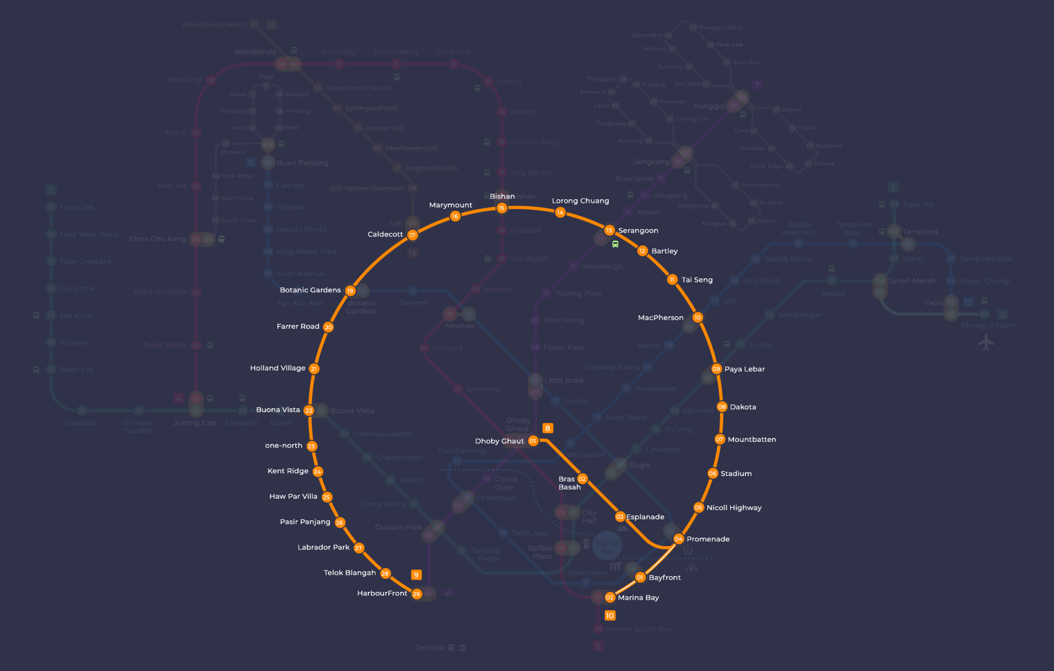
Paya Lebar MRT station at a glance
| Station codes | CC9EW8 |
|---|---|
| Lines | Circle Line East West Line |
| Line colour | Yellow line (Circle Line) Green line (East West Line) |
| Interchange | Yes, change between 2 lines here |
| Chinese name | 巴耶利峇 |
| Tamil name | பாய லேபார் |
| Next stations | |
| Train times | Circle Line: first train leaves the terminus at 5:37 AM, last train 11:56 PM East West Line: first train leaves the terminus at 5:19 AM, last train 11:23 PM Full first and last train guide |
See Paya Lebar on the map. The interactive map opens with this station highlighted, so you can trace the route from where you are.
Passengers on the East West Line can travel directly to Eunos in one direction and Aljunied in the other. Those switching to the Circle Line can continue towards Dakota or MacPherson. The interchange between the two lines means that Paya Lebar is a practical stop for journeys that would otherwise require longer or less direct routes, and many commuters change trains here rather than travelling into the city centre to transfer.
The station is within walking distance of Paya Lebar Quarter, a large mixed commercial and retail development, as well as the adjacent Paya Lebar Square and SingPost Centre. These buildings form a cluster of shopping, dining and office space that has made the immediate area a recognised destination in the east. The surrounding streets also include older shophouses and local businesses that reflect the character of the broader Paya Lebar neighbourhood.
Around Paya Lebar MRT station
Paya Lebar station sits at the heart of a busy commercial and retail district in eastern Singapore. The area is anchored by several shopping malls including Paya Lebar Square and Tanjong Katong Complex, drawing shoppers and office workers throughout the day. A number of food centres nearby also serve the surrounding residential community.
| Place | Type | Distance | Why go |
|---|---|---|---|
| Kopitiam | Food centre | About 50 m (~1 min walk) | A convenient spot for a quick, affordable local meal close to the station. |
| Cantine | Food centre | About 130 m (~2 min walk) | A food centre offering a range of cooked food stall options. |
| Paya Lebar Square | Shopping mall | About 150 m (~2 min walk) | A shopping mall with retail shops, dining options and services. |
| Malaysia Chiak! | Food centre | About 190 m (~3 min walk) | A food centre with Malaysian food stalls popular with the local crowd. |
| Tanjong Katong Complex | Shopping mall | About 220 m (~4 min walk) | A shopping mall catering to everyday retail and dining needs. |
| SingPost Centre | Shopping mall | About 290 m (~5 min walk) | A shopping mall that also houses postal and lifestyle services. |
| Sri Sivan Temple | Place of worship | About 450 m (~7 min walk) | A Hindu temple serving the local and regional worshipping community. |
| Geylang Serai Heritage Gallery | Museum | About 510 m (~8 min walk) | A gallery exploring the heritage and culture of the Geylang Serai area. |
Places and straight-line distances from OpenStreetMap data (© OpenStreetMap contributors). Actual walking routes may be longer.
How to get to Paya Lebar by MRT
Worked out from the network map. Stop counts are station to station and do not include walking or waiting time.
| From Changi Airport | Take the East West Line from Changi Airport to Paya Lebar (6 stops). About 6 stops, no changes. |
|---|---|
| From Orchard | Take the North South Line from Orchard to City Hall (3 stops), then change to the East West Line from City Hall to Paya Lebar (5 stops). About 8 stops with 1 change. |
| From City Hall | Take the East West Line from City Hall to Paya Lebar (5 stops). About 5 stops, no changes. |
| From Jurong East | Take the East West Line from Jurong East to Paya Lebar (16 stops). About 16 stops, no changes. |
| From Woodlands | Take the North South Line from Woodlands to Bishan (8 stops), then change to the Circle Line from Bishan to Paya Lebar (6 stops). About 14 stops with 1 change. |
| From HarbourFront | Take the North East Line from HarbourFront to Outram Park (1 stop), then change to the East West Line from Outram Park to Paya Lebar (8 stops). About 9 stops with 1 change. |
Fares from Paya Lebar MRT station
A trip from Paya Lebar to Changi Airport (about 13 km) costs S$1.98 on an adult SimplyGo or EZ-Link card. Fares are charged by distance, so the table below shows the estimated adult card fare from Paya Lebar to the main hubs, the early bird fare for journeys that start before 7.45am on weekdays, and the fare that applies from 26 December 2026.
| To | Distance | Adult card | Before 7.45am | From 26 Dec 2026 |
|---|---|---|---|---|
| Changi Airport | about 13 km, 6 stops | S$1.98 | S$1.48 | S$2.11 |
| Orchard | about 9 km, 8 stops | S$1.82 | S$1.32 | S$1.95 |
| City Hall | about 6 km, 5 stops | S$1.59 | S$1.09 | S$1.72 |
| Raffles Place | about 7 km, 6 stops | S$1.75 | S$1.25 | S$1.88 |
| Jurong East | about 23 km, 16 stops | S$2.36 | S$1.86 | S$2.49 |
| Woodlands | about 25 km, 14 stops | S$2.42 | S$1.92 | S$2.55 |
| HarbourFront | about 12 km, 9 stops | S$1.94 | S$1.44 | S$2.07 |
| Marina Bay | about 8 km, 7 stops | S$1.82 | S$1.32 | S$1.95 |
Estimated from the route distance between stations and the Public Transport Council fare table in force from 27 December 2025. The exact fare can differ by one band. Cash fares are higher. Use the fare calculator for any other journey, or check your fare on the SimplyGo app.
Tips for using Paya Lebar MRT station
- Paya Lebar is an interchange station between the Circle Line and East West Line, so plan your onward journey using whichever line best connects to your destination.
- Kopitiam is the nearest food centre at roughly 50 metres from the station, making it the most practical choice for a quick meal before or after your journey.
- Most of the shopping malls and food centres are within a short walk of approximately five minutes or less, so walking is usually the easiest option for reaching them.
- During morning and evening peak hours the station can be busy as it serves both commuters and shoppers, so allow a little extra time when travelling through.
All stations on the Circle Line
In order along the line, with Paya Lebar marked. Stations with their own guide are linked.
| Code | Station | Interchange |
|---|---|---|
| CC1 | Dhoby Ghaut | NS / NE / CC |
| CC2 | Bras Basah | None |
| CC3 | Esplanade | None |
| CC4 | Promenade | CC / DT |
| CC5 | Nicoll Highway | None |
| CC6 | Stadium | None |
| CC7 | Mountbatten | None |
| CC8 | Dakota | None |
| CC9 | Paya Lebar (you are here) | CC / EW |
| CC10 | MacPherson | CC / DT |
| CC11 | Tai Seng | None |
| CC12 | Bartley | None |
| CC13 | Serangoon | CC / NE |
| CC14 | Lorong Chuan | None |
| CC15 | Bishan | NS / CC |
| CC16 | Marymount | None |
| CC17 | Caldecott | CC / TE |
| CC19 | Botanic Gardens | DT / CC |
| CC20 | Farrer Road | None |
| CC21 | Holland Village | None |
| CC22 | Buona Vista | EW / CC |
| CC23 | one-north | None |
| CC24 | Kent Ridge | None |
| CC25 | Haw Par Villa | None |
| CC26 | Pasir Panjang | None |
| CC27 | Labrador Park | None |
| CC28 | Telok Blangah | None |
| CC29 | HarbourFront | CC / NE |
| CC30 | Keppel | None |
| CC31 | Cantonment | None |
| CC32 | Prince Edward Road | None |
Read the full Circle Line guide.
All stations on the East West Line
In order along the line, with Paya Lebar marked. Stations with their own guide are linked.
| Code | Station | Interchange |
|---|---|---|
| EW1 | Pasir Ris | None |
| EW2 | Tampines | EW / DT |
| EW3 | Simei | None |
| EW4 | Tanah Merah | None |
| EW5 | Bedok | None |
| EW6 | Kembangan | None |
| EW7 | Eunos | None |
| EW8 | Paya Lebar (you are here) | CC / EW |
| EW9 | Aljunied | None |
| EW10 | Kallang | None |
| EW11 | Lavender | None |
| EW12 | Bugis | DT / EW |
| EW13 | City Hall | EW / NS |
| EW14 | Raffles Place | NS / EW |
| EW15 | Tanjong Pagar | None |
| EW16 | Outram Park | TE / EW / NE |
| EW17 | Tiong Bahru | None |
| EW18 | Redhill | None |
| EW19 | Queenstown | None |
| EW20 | Commonwealth | None |
| EW21 | Buona Vista | EW / CC |
| EW22 | Dover | None |
| EW23 | Clementi | None |
| EW24 | Jurong East | EW / NS |
| EW25 | Chinese Garden | None |
| EW26 | Lakeside | None |
| EW27 | Boon Lay | None |
| EW28 | Pioneer | None |
| EW29 | Joo Koon | None |
| EW30 | Gul Circle | None |
| EW31 | Tuas Crescent | None |
| EW32 | Tuas West Road | None |
| EW33 | Tuas Link | None |
Read the full East West Line guide.
Paya Lebar MRT station: common questions
Which line is Paya Lebar MRT station on?
Paya Lebar is on the Circle Line and the East West Line. Its station codes are CC9 and EW8.
Is Paya Lebar an interchange station?
Yes. You can change between the Circle Line and the East West Line inside the station without leaving the paid area.
What time is the first and last train at Paya Lebar?
Times below are for the first and last train leaving the line terminus; trains reach Paya Lebar a few minutes later depending on its position on the line. Circle Line first train 5:37 AM, last train 11:56 PM. East West Line first train 5:19 AM, last train 11:23 PM. Check the operator for holiday changes.
What is near Paya Lebar MRT station?
The area around Paya Lebar station has several food centres and shopping malls within walking distance, including Kopitiam, Paya Lebar Square, Tanjong Katong Complex and SingPost Centre, as well as Sri Sivan Temple and the Geylang Serai Heritage Gallery a little further along.
Which shopping mall or food centre is closest to Paya Lebar MRT station?
The closest food centre is Kopitiam at approximately 50 metres, and the closest shopping mall is Paya Lebar Square at approximately 150 metres, both reachable in a short walk.
How far is the Geylang Serai Heritage Gallery from Paya Lebar station?
The Geylang Serai Heritage Gallery is approximately 510 metres from the station, which is roughly an eight-minute walk.
How do I get to Paya Lebar from Changi Airport by MRT?
Take the East West Line from Changi Airport to Paya Lebar (6 stops). About 6 stops, no changes.
Sources: station codes, line colours and interchanges from the LTA rail system map; operating hours from SMRT and SBS Transit. Last reviewed September 2026.
News and guides mentioning Paya Lebar
- Sengkang West LRT Reopens Oct 4: What Riders Need to Know 5 Oct 2026
- Circle Line Wayfinding Signs Upgraded After Passenger Feedback 5 Jul 2026
- Best MRT Routes for Marina Bay Sands & Gardens 5 May 2026
- The Singapore MRT Map 2026: Best Routes and What Changed 17 Aug 2024
Plan the rest of the trip
Every station on the Circle Line and the East West Line is listed on its line guide, with the full route and interchanges. For times, see the first and last train guide, and for the whole network in one view use the interactive Singapore MRT map or the PDF map.