
Marsiling MRT Station
Marsiling MRT station is a station on the North South Line, carrying the code NS8. It sits in the Marsiling planning area in the north of Singapore, serving a largely residential neighbourhood made up of public housing estates managed by the Housing and Development Board.
Marsiling on the North South Line map
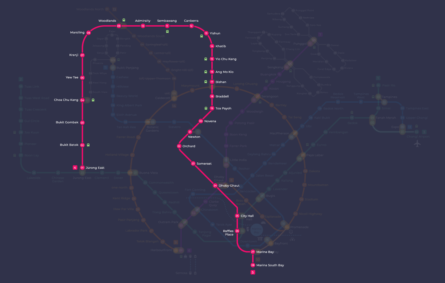
Marsiling MRT station at a glance
| Station codes | NS8 |
|---|---|
| Lines | North South Line |
| Line colour | Red line (North South Line) |
| Interchange | No, single line station |
| Chinese name | 马西岭 |
| Tamil name | மார்சிலிங் |
| Next stations | |
| Train times | North South Line: first train leaves the terminus at 5:16 AM, last train 11:48 PM Full first and last train guide |
See Marsiling on the map. The interactive map opens with this station highlighted, so you can trace the route from where you are.
From Marsiling, trains run directly to Kranji station (NS7) in one direction and Woodlands station (NS9) in the other. Woodlands is an interchange where passengers can switch to the Thomson-East Coast Line, making it straightforward to continue journeys into the city centre or towards the eastern parts of Singapore without needing to change trains at Marsiling itself.
The area around the station is predominantly made up of HDB blocks, neighbourhood shops, and local amenities typical of a mature public housing town. Marsiling Community Club and nearby market and hawker facilities serve residents in the immediate vicinity, and the general neighbourhood has a quiet, lived-in character rather than major tourist attractions or large commercial developments.
Around Marsiling MRT station
Marsiling MRT station sits within a predominantly residential neighbourhood in the Woodlands planning area, surrounded by public housing estates and local amenities. Marsiling Park and Woodlands Town Park East offer green space for residents nearby, while Marsiling Mall provides everyday shopping close to the station. The area has a strong community character, with facilities such as Fuchun Community Club serving the local population.
| Place | Type | Distance | Why go |
|---|---|---|---|
| Fuchun Community Club | Community club | About 350 m (~6 min walk) | Visit for community activities, courses, and recreational programmes for residents. |
| Woodlands Street 12 Hawker Centre | Food centre | About 640 m (~10 min walk) | Head here for a wide variety of affordable local food and hawker dishes. |
| Marsiling Mall | Shopping mall | About 660 m (~11 min walk) | A local shopping mall with everyday retail and dining options. |
| Marsiling Park | Park | About 680 m (~11 min walk) | A public park suitable for outdoor walks, exercise, and leisure. |
| Woodlands Town Park East | Park | About 730 m (~12 min walk) | Another park option offering open green space for recreational use. |
| Woodlands Stadium | Stadium | About 780 m (~13 min walk) | A sports facility for athletics, football, and other sporting activities. |
| The Woodgrove | Shopping mall | About 870 m (~14 min walk) | A neighbourhood shopping mall with retail and dining options. |
| Sri Siva Krishna Temple | Place of worship | About 1020 m (~17 min walk) | A Hindu temple for worship and religious observances. |
Places and straight-line distances from OpenStreetMap data (© OpenStreetMap contributors). Actual walking routes may be longer.
How to get to Marsiling by MRT
Worked out from the network map. Stop counts are station to station and do not include walking or waiting time.
| From Changi Airport | Take the East West Line from Changi Airport to Paya Lebar (6 stops), then change to the Circle Line from Paya Lebar to Bishan (6 stops), then change to the North South Line from Bishan to Marsiling (9 stops). About 21 stops with 2 changes. |
|---|---|
| From Orchard | Take the North South Line from Orchard to Marsiling (14 stops). About 14 stops, no changes. |
| From City Hall | Take the North South Line from City Hall to Marsiling (17 stops). About 17 stops, no changes. |
| From Jurong East | Take the North South Line from Jurong East to Marsiling (6 stops). About 6 stops, no changes. |
| From Woodlands | Take the North South Line from Woodlands to Marsiling (1 stop). About 1 stops, no changes. |
| From HarbourFront | Take the North East Line from HarbourFront to Outram Park (1 stop), then change to the East West Line from Outram Park to Jurong East (8 stops), then change to the North South Line from Jurong East to Marsiling (6 stops). About 15 stops with 2 changes. |
Fares from Marsiling MRT station
A trip from Marsiling to Changi Airport (about 40 km) costs S$2.56 on an adult SimplyGo or EZ-Link card. Fares are charged by distance, so the table below shows the estimated adult card fare from Marsiling to the main hubs, the early bird fare for journeys that start before 7.45am on weekdays, and the fare that applies from 26 December 2026.
| To | Distance | Adult card | Before 7.45am | From 26 Dec 2026 |
|---|---|---|---|---|
| Changi Airport | about 40 km, 21 stops | S$2.56 | S$2.06 | S$2.69 |
| Orchard | about 26 km, 14 stops | S$2.42 | S$1.92 | S$2.55 |
| City Hall | about 29 km, 17 stops | S$2.45 | S$1.95 | S$2.58 |
| Raffles Place | about 30 km, 16 stops | S$2.46 | S$1.96 | S$2.59 |
| Jurong East | about 14 km, 6 stops | S$2.02 | S$1.52 | S$2.15 |
| Woodlands | about 2 km, 1 stop | S$1.28 | S$0.78 | S$1.40 |
| HarbourFront | about 30 km, 15 stops | S$2.47 | S$1.97 | S$2.60 |
| Marina Bay | about 28 km, 18 stops | S$2.44 | S$1.94 | S$2.57 |
Estimated from the route distance between stations and the Public Transport Council fare table in force from 27 December 2025. The exact fare can differ by one band. Cash fares are higher. Use the fare calculator for any other journey, or check your fare on the SimplyGo app.
Tips for using Marsiling MRT station
- Fuchun Community Club is the closest major landmark at roughly 350 metres, making it an easy short walk from the station.
- Marsiling Mall and Woodlands Street 12 Hawker Centre are both around 10 to 11 minutes on foot, but taking a bus can save time if you prefer not to walk.
- For Sri Siva Krishna Temple, which is approximately 1,020 metres away, consider taking a bus rather than walking, especially during hot or rainy weather.
- During peak hours the station and surrounding roads can be busier, so allow extra travel time if you are heading to Woodlands Stadium or The Woodgrove.
All stations on the North South Line
In order along the line, with Marsiling marked. Stations with their own guide are linked.
| Code | Station | Interchange |
|---|---|---|
| NS1 | Jurong East | EW / NS |
| NS2 | Bukit Batok | None |
| NS3 | Bukit Gombak | None |
| NS4 | Choa Chu Kang | NS / BP |
| NS5 | Yew Tee | None |
| NS7 | Kranji | None |
| NS8 | Marsiling (you are here) | None |
| NS9 | Woodlands | NS / TE |
| NS10 | Admiralty | None |
| NS11 | Sembawang | None |
| NS12 | Canberra | None |
| NS13 | Yishun | None |
| NS14 | Khatib | None |
| NS15 | Yio Chu Kang | None |
| NS16 | Ang Mo Kio | None |
| NS17 | Bishan | NS / CC |
| NS18 | Braddell | None |
| NS19 | Toa Payoh | None |
| NS20 | Novena | None |
| NS21 | Newton | NS / DT |
| NS22 | Orchard | TE / NS |
| NS23 | Somerset | None |
| NS24 | Dhoby Ghaut | NS / NE / CC |
| NS25 | City Hall | EW / NS |
| NS26 | Raffles Place | NS / EW |
| NS27 | Marina Bay | CE / TE / NS |
| NS28 | Marina South Pier | None |
Read the full North South Line guide.
Marsiling MRT station: common questions
Which line is Marsiling MRT station on?
Marsiling is on the North South Line. Its station code is NS8.
Is Marsiling an interchange station?
No. Marsiling is served by the North South Line only. The nearest interchange is shown in the next stations row above.
What time is the first and last train at Marsiling?
Times below are for the first and last train leaving the line terminus; trains reach Marsiling a few minutes later depending on its position on the line. North South Line first train 5:16 AM, last train 11:48 PM. Check the operator for holiday changes.
What is near Marsiling MRT station?
Nearby places include Fuchun Community Club, Woodlands Street 12 Hawker Centre, Marsiling Mall, Marsiling Park, Woodlands Town Park East, Woodlands Stadium, The Woodgrove, and Sri Siva Krishna Temple. These cover a range of community, dining, shopping, and recreational options within approximately one kilometre of the station.
Which mall or food centre is closest to Marsiling MRT station?
Marsiling Mall is the closest shopping mall at approximately 660 metres, or roughly an 11-minute walk. Woodlands Street 12 Hawker Centre is slightly closer at approximately 640 metres, making it a good option for a nearby meal.
How far is Woodlands Stadium from Marsiling MRT station?
Woodlands Stadium is approximately 780 metres from the station in a straight line, which is roughly a 13-minute walk. Distances are approximate and actual walking time may vary.
How do I get to Marsiling from Changi Airport by MRT?
Take the East West Line from Changi Airport to Paya Lebar (6 stops), then change to the Circle Line from Paya Lebar to Bishan (6 stops), then change to the North South Line from Bishan to Marsiling (9 stops). About 21 stops with 2 changes.
Sources: station codes, line colours and interchanges from the LTA rail system map; operating hours from SMRT and SBS Transit. Last reviewed September 2026.
News and guides mentioning Marsiling
- Woodlands MRT Smokers Leave Butts: What Riders Can Do 15 Oct 2026
- Vegetation Fire Near Gali Batu Depot: What Happened 8 Sep 2026
Plan the rest of the trip
Every station on the North South Line is listed on its line guide, with the full route and interchanges. For times, see the first and last train guide, and for the whole network in one view use the interactive Singapore MRT map or the PDF map.