
Bukit Gombak MRT Station
Bukit Gombak MRT station serves the residential town of Bukit Gombak in the western part of Singapore. It operates on the North South Line and carries the station code NS3. The station sits within a largely residential area, surrounded by public housing estates and the everyday amenities that support a neighbourhood community. It is a single-line station with no interchange facilities.
Bukit Gombak on the North South Line map
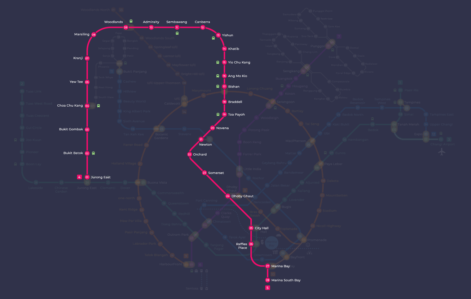
Bukit Gombak MRT station at a glance
| Station codes | NS3 |
|---|---|
| Lines | North South Line |
| Line colour | Red line (North South Line) |
| Interchange | No, single line station |
| Chinese name | 武吉甘柏 |
| Tamil name | புக்கிட் கோம்பாக் |
| Next stations | |
| Train times | North South Line: first train leaves the terminus at 5:16 AM, last train 11:48 PM Full first and last train guide |
See Bukit Gombak on the map. The interactive map opens with this station highlighted, so you can trace the route from where you are.
Travelling from Bukit Gombak, you can head south along the North South Line towards Bukit Batok, which connects onward into the city and towards stations such as Jurong East, an interchange with the East West Line. Heading north, the next stop is Choa Chu Kang, which is an interchange with the Light Rapid Transit loop serving the surrounding housing estates. There are no direct transfers available at Bukit Gombak itself, so passengers needing to change lines will do so at a neighbouring station.
The station is close to Bukit Gombak Park and the Little Guilin area, a well-known local spot featuring a granite hill and a lake that draws visitors from across Singapore. The surrounding neighbourhood is a typical Housing and Development Board estate with markets, shops, and food centres within walking distance. The general character of the area is quiet and residential, making the station primarily a commuter stop for people living in and around Bukit Gombak.
Around Bukit Gombak MRT station
Bukit Gombak station sits within a largely residential neighbourhood in western Singapore, well served by everyday amenities. The area around the station features community facilities such as the Bukit Gombak Neighbourhood Centre and sporting venues including Bukit Gombak Stadium. Several food centres are within a short walk, making this a practical base for residents and visitors alike.
| Place | Type | Distance | Why go |
|---|---|---|---|
| Bukit Gombak Neighbourhood Centre | Community club | About 60 m (~1 min walk) | Visit for community events, classes and neighbourhood social activities. |
| Sin Huat Lee Restaurant | Food centre | About 130 m (~2 min walk) | Head here for a local dining experience with a range of cooked food options. |
| Chang Cheng Mee Wah | Food centre | About 170 m (~3 min walk) | A popular spot for affordable local meals and hawker fare. |
| Air Padang | Food centre | About 200 m (~3 min walk) | Drop by for casual local food in a neighbourhood food centre setting. |
| Bukit Gombak Stadium | Stadium | About 210 m (~3 min walk) | Use the stadium facilities for sports, fitness activities or watching local matches. |
| Perdaus | Community club | About 210 m (~3 min walk) | A community club serving the local Malay Muslim community with programmes and activities. |
| Stream | Attraction | About 720 m (~12 min walk) | A natural stream attraction worth visiting for a quiet outdoor experience. |
| West Mall | Shopping mall | About 1020 m (~17 min walk) | A shopping mall offering retail, dining and entertainment options a short distance away. |
Places and straight-line distances from OpenStreetMap data (© OpenStreetMap contributors). Actual walking routes may be longer.
How to get to Bukit Gombak by MRT
Worked out from the network map. Stop counts are station to station and do not include walking or waiting time.
| From Changi Airport | Take the East West Line from Changi Airport to Jurong East (22 stops), then change to the North South Line from Jurong East to Bukit Gombak (2 stops). About 24 stops with 1 change. |
|---|---|
| From Orchard | Take the North South Line from Orchard to Bukit Gombak (18 stops). About 18 stops, no changes. |
| From City Hall | Take the East West Line from City Hall to Jurong East (11 stops), then change to the North South Line from Jurong East to Bukit Gombak (2 stops). About 13 stops with 1 change. |
| From Jurong East | Take the North South Line from Jurong East to Bukit Gombak (2 stops). About 2 stops, no changes. |
| From Woodlands | Take the North South Line from Woodlands to Bukit Gombak (5 stops). About 5 stops, no changes. |
| From HarbourFront | Take the North East Line from HarbourFront to Outram Park (1 stop), then change to the East West Line from Outram Park to Jurong East (8 stops), then change to the North South Line from Jurong East to Bukit Gombak (2 stops). About 11 stops with 2 changes. |
Fares from Bukit Gombak MRT station
A trip from Bukit Gombak to Changi Airport (about 39 km) costs S$2.56 on an adult SimplyGo or EZ-Link card. Fares are charged by distance, so the table below shows the estimated adult card fare from Bukit Gombak to the main hubs, the early bird fare for journeys that start before 7.45am on weekdays, and the fare that applies from 26 December 2026.
| To | Distance | Adult card | Before 7.45am | From 26 Dec 2026 |
|---|---|---|---|---|
| Changi Airport | about 39 km, 24 stops | S$2.56 | S$2.06 | S$2.69 |
| Orchard | about 36 km, 18 stops | S$2.52 | S$2.02 | S$2.65 |
| City Hall | about 20 km, 13 stops | S$2.30 | S$1.80 | S$2.43 |
| Raffles Place | about 19 km, 12 stops | S$2.24 | S$1.74 | S$2.37 |
| Jurong East | about 3 km, 2 stops | S$1.38 | S$0.88 | S$1.51 |
| Woodlands | about 12 km, 5 stops | S$1.94 | S$1.44 | S$2.07 |
| HarbourFront | about 20 km, 11 stops | S$2.27 | S$1.77 | S$2.40 |
| Marina Bay | about 20 km, 13 stops | S$2.27 | S$1.77 | S$2.40 |
Estimated from the route distance between stations and the Public Transport Council fare table in force from 27 December 2025. The exact fare can differ by one band. Cash fares are higher. Use the fare calculator for any other journey, or check your fare on the SimplyGo app.
Tips for using Bukit Gombak MRT station
- Most food centres and community facilities are within a comfortable three-minute walk from the station, so no additional transport is needed for these stops.
- West Mall is approximately one kilometre away and may be more comfortably reached by bus rather than on foot, especially in hot or rainy weather.
- The stream attraction is around 12 minutes on foot, so allow extra time and wear comfortable footwear if you plan to visit.
- During peak commuting hours the station can be busier than usual, so allow a little extra time if you are connecting onward along the North South Line.
All stations on the North South Line
In order along the line, with Bukit Gombak marked. Stations with their own guide are linked.
| Code | Station | Interchange |
|---|---|---|
| NS1 | Jurong East | EW / NS |
| NS2 | Bukit Batok | None |
| NS3 | Bukit Gombak (you are here) | None |
| NS4 | Choa Chu Kang | NS / BP |
| NS5 | Yew Tee | None |
| NS7 | Kranji | None |
| NS8 | Marsiling | None |
| NS9 | Woodlands | NS / TE |
| NS10 | Admiralty | None |
| NS11 | Sembawang | None |
| NS12 | Canberra | None |
| NS13 | Yishun | None |
| NS14 | Khatib | None |
| NS15 | Yio Chu Kang | None |
| NS16 | Ang Mo Kio | None |
| NS17 | Bishan | NS / CC |
| NS18 | Braddell | None |
| NS19 | Toa Payoh | None |
| NS20 | Novena | None |
| NS21 | Newton | NS / DT |
| NS22 | Orchard | TE / NS |
| NS23 | Somerset | None |
| NS24 | Dhoby Ghaut | NS / NE / CC |
| NS25 | City Hall | EW / NS |
| NS26 | Raffles Place | NS / EW |
| NS27 | Marina Bay | CE / TE / NS |
| NS28 | Marina South Pier | None |
Read the full North South Line guide.
Bukit Gombak MRT station: common questions
Which line is Bukit Gombak MRT station on?
Bukit Gombak is on the North South Line. Its station code is NS3.
Is Bukit Gombak an interchange station?
No. Bukit Gombak is served by the North South Line only. The nearest interchange is shown in the next stations row above.
What time is the first and last train at Bukit Gombak?
Times below are for the first and last train leaving the line terminus; trains reach Bukit Gombak a few minutes later depending on its position on the line. North South Line first train 5:16 AM, last train 11:48 PM. Check the operator for holiday changes.
What is near Bukit Gombak MRT station?
The station is surrounded by several food centres, including Sin Huat Lee Restaurant and Chang Cheng Mee Wah, as well as community facilities like the Bukit Gombak Neighbourhood Centre and Bukit Gombak Stadium, all within approximately 210 metres.
Which shopping mall is closest to Bukit Gombak station and how far is it?
West Mall is the nearest shopping mall, at approximately 1,020 metres straight-line distance, which is roughly a 17-minute walk.
How far is Bukit Gombak Stadium from the station?
Bukit Gombak Stadium is approximately 210 metres away in a straight line, making it roughly a three-minute walk from the station.
How do I get to Bukit Gombak from Changi Airport by MRT?
Take the East West Line from Changi Airport to Jurong East (22 stops), then change to the North South Line from Jurong East to Bukit Gombak (2 stops). About 24 stops with 1 change.
Sources: station codes, line colours and interchanges from the LTA rail system map; operating hours from SMRT and SBS Transit. Last reviewed September 2026.
Plan the rest of the trip
Every station on the North South Line is listed on its line guide, with the full route and interchanges. For times, see the first and last train guide, and for the whole network in one view use the interactive Singapore MRT map or the PDF map.