Circle Line (Yellow Line MRT) guide
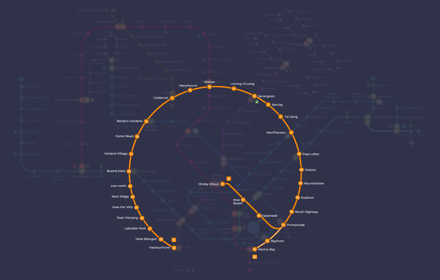
The Circle Line links Singapore’s main radial MRT lines without forcing passengers through the city centre. Instead of running out from downtown like the older lines, it curves around the Central Region and crosses the North South, East West, North East, Downtown and Thomson East Coast lines along the way. It is drawn in orange on the official rail map, though many riders call it the Yellow Line. Every station carries a code that starts with CC, except the two stations on the Marina Bay extension, which use CE. On any circle line map you will see a loop through the middle of the island, plus a short spur that leaves the loop at Promenade and ends at Dhoby Ghaut.
The spur ends at Dhoby Ghaut (CC1). The loop runs from Promenade through Nicoll Highway, Paya Lebar, Serangoon, Bishan, Buona Vista and HarbourFront, then back through Keppel, Cantonment and Prince Edward Road (CC32) to Marina Bay (CE2) and Bayfront (CE1). The line serves the Civic District and Marina Bay, the Kallang and Mountbatten areas, Paya Lebar, the north eastern estates around Serangoon and Bishan, the western corridor through Holland Village and one-north, and the southern waterfront down to HarbourFront and Keppel. SMRT Trains operates the line. It runs entirely underground, its trains are fully automated, and it has 33 stations open.
Circle Line map: route and where it goes
Starting at Dhoby Ghaut, at the top of Orchard Road, the line heads east under the Civic District to Bras Basah and Esplanade, then reaches Promenade in Marina Centre, where the spur joins the loop. Heading north east, trains call at Nicoll Highway and Stadium, the station for the National Stadium, then pass through the low rise neighbourhoods of Mountbatten and Dakota. Paya Lebar is a major transfer point with the East West Line. From there the line turns north through MacPherson, the industrial and office area at Tai Seng, and Bartley.
The northern arc serves large housing estates. Serangoon and Bishan are two of the busiest stops because they connect to the North East and North South lines. After Lorong Chuan, Marymount and Caldecott, the line turns south west to Botanic Gardens, then continues through Farrer Road and Holland Village to Buona Vista. Next comes one-north, a business and research district, followed by Kent Ridge, which serves the area around the National University of Singapore and its nearby hospital.
The western and southern stretch follows the coast. Trains run through Haw Par Villa, Pasir Panjang, Labrador Park and Telok Blangah to HarbourFront, where you can change to the North East Line. The newest section then continues east through Keppel, Cantonment and Prince Edward Road to Marina Bay and Bayfront, before returning to Promenade. Because this closes the loop, the circle line map no longer shows a gap between HarbourFront and Marina Bay.
Interchange stations
- Dhoby Ghaut (CC1): change to the North South Line (NS24) and the North East Line (NE6).
- Promenade (CC4): change to the Downtown Line (DT15).
- Paya Lebar (CC9): change to the East West Line (EW8).
- MacPherson (CC10): change to the Downtown Line (DT26).
- Serangoon (CC13): change to the North East Line (NE12).
- Bishan (CC15): change to the North South Line (NS17).
- Caldecott (CC17): change to the Thomson-East Coast Line (TE9).
- Botanic Gardens (CC19): change to the Downtown Line (DT9).
- Buona Vista (CC22): change to the East West Line (EW21).
- HarbourFront (CC29): change to the North East Line (NE1).
- Bayfront (CE1): change to the Downtown Line (DT16).
- Marina Bay (CE2): change to the Thomson-East Coast Line (TE20) and the North South Line (NS27).
History
The line began in the 1990s as a proposal for a smaller Marina Line serving the National Stadium, Shenton Way and Marina South, alongside a separate idea for an outer circle linking Buona Vista and Paya Lebar via Bishan and Serangoon. In April 2001 the two plans were combined, and the Dhoby Ghaut to Stadium section became the first stage of the Circle Line. Construction started in 2002. On 20 April 2004, tunnels near Nicoll Highway station collapsed together with part of Nicoll Highway itself, killing four people. Nicoll Highway station was later rebuilt about 100 m south of its original site, and the opening of Stage 1 slipped from 2007 to 2009.
The first section to carry passengers was Stage 3, from Bartley to Marymount, which opened on 28 May 2009. Stages 1 and 2 followed on 17 April 2010, extending service to Dhoby Ghaut. Stages 4 and 5 took the line to HarbourFront on 8 October 2011, and the two station extension to Marina Bay opened on 14 January 2012. Stage 6, the link from HarbourFront to Marina Bay via Keppel, Cantonment and Prince Edward Road, opened on 12 July 2026 and completed the loop. Before that, between January and April 2026, the tunnels between Mountbatten and Paya Lebar were closed for strengthening work, and shuttle trains and buses ran in their place.
Tips for riding the line
- Since the line is now a loop, check a circle line map before boarding and choose the direction with fewer stops. For example, HarbourFront to Marina Bay is now much shorter through Keppel, Cantonment and Prince Edward Road than going round the northern arc.
- Dhoby Ghaut sits on a spur, so trips from there to Marina Bay or Bayfront run through Bras Basah, Esplanade and Promenade. Promenade is where the spur meets the loop, which makes it a useful place to change trains within the Circle Line.
- For journeys between the east and west without passing through the city centre, use Paya Lebar for the East West Line on the eastern side and Buona Vista for the same line on the western side.
- The Downtown Line meets the Circle Line at four stations: Botanic Gardens, MacPherson, Promenade and Bayfront. Pick whichever one is closest to your journey rather than always changing in the city.
- Trains run in three car formations, which are shorter than those on the older lines. When you study the circle line map, allow a little extra time at busy transfer points such as Serangoon, Bishan and Paya Lebar during peak hours.
Frequently asked questions
Is the Circle Line the yellow line or the orange line?
Both. The LTA prints the Circle Line in orange on the system map, but commuters in Singapore almost always call it the yellow line. It is the same line, with station codes CC1 to CC34 plus CE1 and CE2.
Who operates the Circle Line MRT?
SMRT operates the Circle Line. It also runs the North South Line, East West Line, Thomson-East Coast Line and Bukit Panjang LRT.
When did the Circle Line become a full loop?
The Circle Line completed its loop on 12 July 2026, when Stage 6 opened with three new stations: Keppel (CC30), Cantonment (CC31) and Prince Edward Road (CC32). A public preview ran from 4 July 2026 before the official opening.
How many stations does the Circle Line have?
The Circle Line has 33 stations across about 39.5 km. That count includes Bayfront (CE1) and Marina Bay (CE2), which now sit on the loop itself rather than on a short spur.
Does the Thomson-East Coast Line interchange with the Circle Line?
Yes. You can change between the two lines at Caldecott (CC17 and TE9) and at Marina Bay (CE2 and TE20). Caldecott is handy for trips between the north and the western half of the loop without going into the city centre.
How do I pay for the Circle Line MRT?
You can pay with an EZ-Link or SimplyGo card, a contactless bank card or a mobile wallet. If you are visiting Singapore, a Singapore Tourist Pass is also available and works across all MRT and LRT lines.