
Punggol Coast MRT Station
Punggol Coast MRT station is an underground station on the North East Line, code NE18, in the northern part of Punggol close to the coast. It is the final stop at the northern end of the line, so every train travelling in this direction terminates here. The station lies within the Punggol Digital District, right beside the new campus of the Singapore Institute of Technology.
Punggol Coast on the North East Line map
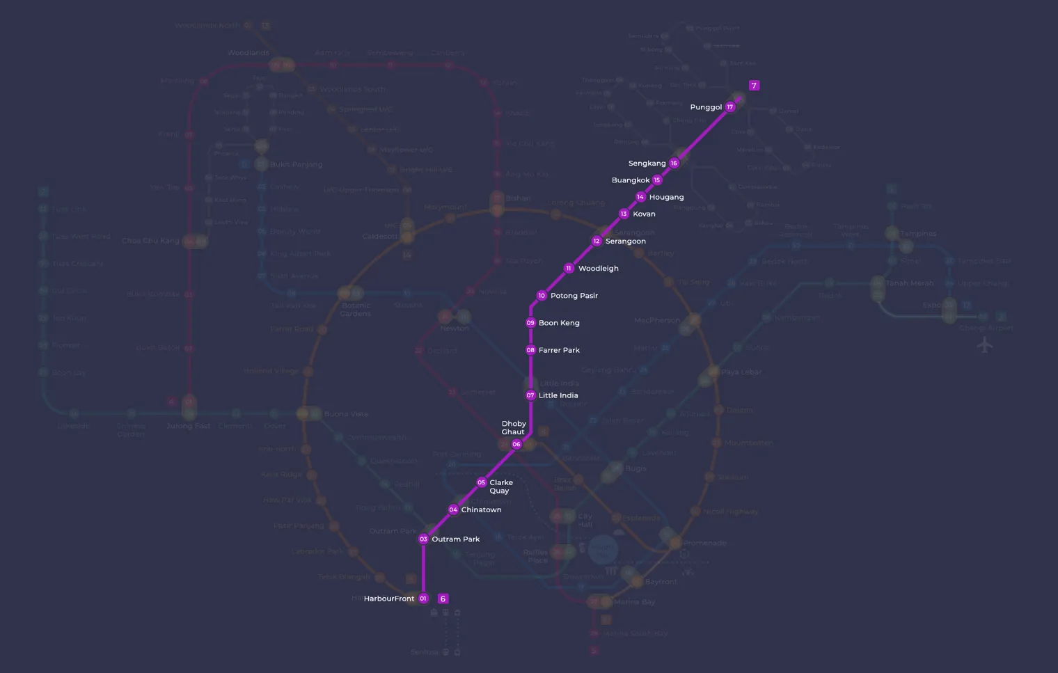
Punggol Coast MRT station at a glance
| Station codes | NE18 |
|---|---|
| Lines | North East Line |
| Line colour | Purple line (North East Line) |
| Interchange | No, single line station |
| Chinese name | 榜鹅海岸 |
| Tamil name | பொங்கோல் கோஸ்ட் |
| Opened | 10 December 2024 (1 year ago) |
| Operator | SBS Transit |
| Station type | Underground |
| Platforms | 2 (1 island platform) |
| Address | 101 New Punggol Road, Singapore 828604 |
| Next stations | |
| Train times | North East Line: first train leaves the terminus at 5:39 AM, last train 11:55 PM Full first and last train guide |
Opening date, operator and ridership figures are LTA data as recorded on Wikipedia.
See Punggol Coast on the map. The interactive map opens with this station highlighted, so you can trace the route from where you are.
Most passengers are university students and staff, people working in the digital district, and residents of the surrounding housing estates. The station also serves Punggol Coast Bus Interchange, around a five-minute walk away. Teck Lee and Punggol Point stations on the Punggol LRT are within walking distance, which makes this a useful transfer point for anyone heading to or from the far north of Punggol.
History of Punggol Coast MRT station
A one-station extension of the North East Line into Punggol North was announced in January 2013, with completion first planned for 2030. The target was later moved forward to 2023 so the line would be ready as the area developed, but pandemic restrictions on construction work pushed the finish back by a year. Punggol Coast MRT station opened to passengers on 10 December 2024 and was expected to serve around 75,000 people in the area.
Inside Punggol Coast MRT station
The Land Transport Authority designed the station itself. Its 11 large concourse columns spread into beams shaped like mangrove roots beneath high ceilings and pendant lights. The station is wheelchair accessible, with wider fare gates for wheelchair users and tactile floor tiles to guide visually impaired passengers, and it has 300 bicycle parking spaces. It is cooled using the Punggol Digital District’s cooling system together with fans at platform level, an approach that earned it Green Mark Platinum certification. Look out for Trajectories by Zul Othman, an Art-in-Transit work that reflects on Punggol’s past, present and future, drawing on the artist’s teenage years cycling through the area.
For visitors, the station is a convenient starting point for the Punggol waterfront. Punggol Heritage Trail Park is about four minutes on foot, and Punggol Point Park is roughly a ten-minute walk, with Punggol Beach and Coney Island also within easy reach. For a meal, Punggol Coast Hawker Centre is about six minutes away, while Maxim Tam Chiak kopitiam is a little closer at around four minutes.
Students and staff can reach the Singapore Institute of Technology in about five minutes, and the Campus Heart park is a similar distance. Residents also use the station to reach Punggol Coast Mall, Northshore Plaza and Waterway Point, or to change to buses at the interchange.
Around Punggol Coast MRT station
Punggol Coast MRT station sits within a modern mixed-use district at the northeastern tip of Singapore, anchored by the Singapore Institute of Technology campus and supported by nearby food centres and green spaces. The area blends student life with recreational amenities, including Punggol Heritage Trail Park and Punggol Point Park. It is a growing neighbourhood with relatively low-rise development and a distinctly waterfront character.
| Place | Type | Distance | Why go |
|---|---|---|---|
| Punggol Heritage Trail Park | Park | About 220 m (~4 min walk) | Visit for a scenic heritage trail along the Punggol waterfront. |
| Maxim Tam Chiak kopitiam | Food centre | About 250 m (~4 min walk) | A local kopitiam offering casual meals and drinks. |
| Campus Heart | Park | About 270 m (~4 min walk) | An outdoor campus park suitable for leisure and relaxation. |
| Wholesome | Food centre | About 280 m (~5 min walk) | A food centre with a range of dining options for students and visitors. |
| Punggol Coast Bus Interchange | Bus interchange | About 310 m (~5 min walk) | The main bus interchange serving the Punggol Coast area. |
| Singapore Institute of Technology | University | About 320 m (~5 min walk) | The university campus home to Singapore Institute of Technology. |
| Punggol Coast Hawker Centre | Food centre | About 350 m (~6 min walk) | A hawker centre with a variety of local food stalls. |
| Punggol Point Park | Park | About 630 m (~10 min walk) | A waterfront park at Punggol Point ideal for walks and views. |
Places and straight-line distances from OpenStreetMap data (© OpenStreetMap contributors). Actual walking routes may be longer.
How to get to Punggol Coast by MRT
Worked out from the network map. Stop counts are station to station and do not include walking or waiting time.
| From Changi Airport | Take the East West Line from Changi Airport to Paya Lebar (6 stops), then change to the Circle Line from Paya Lebar to Serangoon (4 stops), then change to the North East Line from Serangoon to Punggol Coast (6 stops). About 16 stops with 2 changes. |
|---|---|
| From Orchard | Take the North South Line from Orchard to Dhoby Ghaut (2 stops), then change to the North East Line from Dhoby Ghaut to Punggol Coast (12 stops). About 14 stops with 1 change. |
| From City Hall | Take the North South Line from City Hall to Dhoby Ghaut (1 stop), then change to the North East Line from Dhoby Ghaut to Punggol Coast (12 stops). About 13 stops with 1 change. |
| From Jurong East | Take the East West Line from Jurong East to Buona Vista (3 stops), then change to the Circle Line from Buona Vista to Serangoon (8 stops), then change to the North East Line from Serangoon to Punggol Coast (6 stops). About 17 stops with 2 changes. |
| From Woodlands | Take the North South Line from Woodlands to Bishan (8 stops), then change to the Circle Line from Bishan to Serangoon (2 stops), then change to the North East Line from Serangoon to Punggol Coast (6 stops). About 16 stops with 2 changes. |
| From HarbourFront | Take the North East Line from HarbourFront to Punggol Coast (16 stops). About 16 stops, no changes. |
Fares from Punggol Coast MRT station
A trip from Punggol Coast to Changi Airport (about 27 km) costs S$2.44 on an adult SimplyGo or EZ-Link card. Fares are charged by distance, so the table below shows the estimated adult card fare from Punggol Coast to the main hubs, the early bird fare for journeys that start before 7.45am on weekdays, and the fare that applies from 26 December 2026.
| To | Distance | Adult card | Before 7.45am | From 26 Dec 2026 |
|---|---|---|---|---|
| Changi Airport | about 27 km, 16 stops | S$2.44 | S$1.94 | S$2.57 |
| Orchard | about 19 km, 14 stops | S$2.24 | S$1.74 | S$2.37 |
| City Hall | about 18 km, 13 stops | S$2.20 | S$1.70 | S$2.33 |
| Raffles Place | about 19 km, 14 stops | S$2.24 | S$1.74 | S$2.37 |
| Jurong East | about 29 km, 17 stops | S$2.45 | S$1.95 | S$2.58 |
| Woodlands | about 30 km, 16 stops | S$2.46 | S$1.96 | S$2.59 |
| HarbourFront | about 22 km, 16 stops | S$2.36 | S$1.86 | S$2.49 |
| Marina Bay | about 20 km, 15 stops | S$2.27 | S$1.77 | S$2.40 |
Estimated from the route distance between stations and the Public Transport Council fare table in force from 27 December 2025. The exact fare can differ by one band. Cash fares are higher. Use the fare calculator for any other journey, or check your fare on the SimplyGo app.
Tips for using Punggol Coast MRT station
- Punggol Heritage Trail Park, Maxim Tam Chiak kopitiam, and Campus Heart are all within a short walk of the station, making them easy to reach on foot.
- Punggol Point Park is roughly 10 minutes away on foot, so allow extra time if heading there, especially in hot or wet weather.
- During university term time, the station and surrounding area can be busier in the mornings and early evenings, so allow extra time at peak hours.
- The Punggol Coast Bus Interchange is approximately 5 minutes away on foot and provides onward connections to other parts of Punggol and beyond if needed.
All stations on the North East Line
In order along the line, with Punggol Coast marked. Stations with their own guide are linked.
| Code | Station | Interchange |
|---|---|---|
| NE1 | HarbourFront | CC / NE |
| NE3 | Outram Park | TE / EW / NE |
| NE4 | Chinatown | DT / NE |
| NE5 | Clarke Quay | None |
| NE6 | Dhoby Ghaut | NS / NE / CC |
| NE7 | Little India | DT / NE |
| NE8 | Farrer Park | None |
| NE9 | Boon Keng | None |
| NE10 | Potong Pasir | None |
| NE11 | Woodleigh | None |
| NE12 | Serangoon | CC / NE |
| NE13 | Kovan | None |
| NE14 | Hougang | None |
| NE15 | Buangkok | None |
| NE16 | Sengkang | NE / STC |
| NE17 | Punggol | NE / PTC |
| NE18 | Punggol Coast (you are here) | None |
Read the full North East Line guide.
Punggol Coast MRT station: common questions
Which line is Punggol Coast MRT station on?
Punggol Coast is on the North East Line. Its station code is NE18.
Is Punggol Coast an interchange station?
No. Punggol Coast is served by the North East Line only. The nearest interchange is shown in the next stations row above.
What time is the first and last train at Punggol Coast?
Times below are for the first and last train leaving the line terminus; trains reach Punggol Coast a few minutes later depending on its position on the line. North East Line first train 5:39 AM, last train 11:55 PM. Check the operator for holiday changes.
What is near Punggol Coast MRT station?
The station is close to several parks, food options, and the Singapore Institute of Technology campus. Nearby highlights include Punggol Heritage Trail Park at approximately 220 m, Maxim Tam Chiak kopitiam at approximately 250 m, and Punggol Coast Hawker Centre at approximately 350 m.
Which food centre is closest to Punggol Coast MRT station?
Maxim Tam Chiak kopitiam is the closest food option, at approximately 250 m from the station, roughly a 4-minute walk. Punggol Coast Hawker Centre is also nearby at approximately 350 m, roughly a 6-minute walk.
How far is Punggol Point Park from Punggol Coast MRT station?
Punggol Point Park is approximately 630 m from the station in a straight line, which is roughly a 10-minute walk.
How do I get to Punggol Coast from Changi Airport by MRT?
Take the East West Line from Changi Airport to Paya Lebar (6 stops), then change to the Circle Line from Paya Lebar to Serangoon (4 stops), then change to the North East Line from Serangoon to Punggol Coast (6 stops). About 16 stops with 2 changes.
Sources: station codes, line colours and interchanges from the LTA rail system map; operating hours from SMRT and SBS Transit. Last reviewed October 2026.
News and guides mentioning Punggol Coast
- Sketching on the MRT: What If Someone Draws Your Child? 6 Nov 2026
- Getting to Sentosa by public transport: MRT, cable car and monorail 6 Nov 2026
- Travelling with luggage on Singapore MRT: lifts, wide gates and quiet times 6 Nov 2026
- MRT floor sleeping: why commuters choose it over empty seats 6 Nov 2026
Plan the rest of the trip
Every station on the North East Line is listed on its line guide, with the full route and interchanges. For times, see the first and last train guide, and for the whole network in one view use the interactive Singapore MRT map or the PDF map.
Exits and buses at Punggol Coast station
Punggol Coast has 2 mapped exits (1 to 2). The numbers match the signs inside the station; the landmark beside each one is the closest mapped place to that entrance, so pick the exit that comes up nearest to where you are going.
- Exit 1: closest to Punggol Heritage Trail Park (about 65 m from the entrance)
- Exit 2
Exit data comes from OpenStreetMap and can change when the station is modified.
Places to visit from Punggol Coast station
See every guide on how to get to Singapore's attractions, hospitals and malls by MRT, with routes and fares from Changi Airport, Orchard and the city.