Punggol LRT (Grey LRT line) guide
The Punggol LRT is a driverless light rail line that links the housing estates of Punggol with Punggol station, where passengers change to the North East Line for trips further into Singapore. It does not run from one end to another like an MRT line. Instead, it forms two loops that meet at Punggol station. People often describe the shape as a pair of butterfly wings. The whole route is elevated and measures 10.3 kilometres. Each station was placed to serve homes within about 400 metres, so most residents of Punggol live a short walk from a stop.
On the official network map the line is shown in grey. Station codes use two prefixes: PE for the East Loop and PW for the West Loop. On platform signs and information screens, yellow marks the East Loop and red marks the West Loop. Both loops start and finish at Punggol station. SBS Transit operates the line. Fourteen loop stations are open, seven on each loop, and with the shared Punggol interchange the line has 15 stations in total. A Punggol LRT map makes this layout easy to follow, because the two loops sit on either side of the town centre.
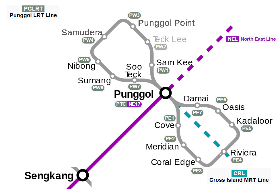
Punggol LRT map: route and where it goes
The East Loop serves the eastern half of Punggol. Leaving Punggol station, trains head south and then bend south-east, running down the middle of Punggol Field. This stretch takes in Cove (PE1), Meridian (PE2) and Coral Edge (PE3). After Coral Edge the line swings north along Punggol East to Riviera (PE4), then turns west to Kadaloor (PE5). From there it follows Punggol Drive through Oasis (PE6) and Damai (PE7) before turning south to return to Punggol station.
The West Loop covers the western and northern parts of the town, including the areas around Punggol Waterway. Trains first head north to Sam Kee (PW1), the stop for Punggol Waterway Park and SAFRA Punggol Clubhouse, and then cross the waterway. The line runs along Sentul Walk to Teck Lee (PW2), which was opened to improve links for students at the Singapore Institute of Technology campus in Punggol. It then turns west to Punggol Point (PW3) and on to Samudera (PW4), which serves Marina Country Club.
After Samudera the West Loop follows Punggol Way and turns south to Nibong (PW5). Between Nibong and Sumang (PW6) it crosses Punggol Waterway a second time. The last stop is Soo Teck (PW7), after which the track turns east and then north back into Punggol station. A separate spur crosses the Tampines Expressway to join the Sengkang LRT, but this is a track connection rather than a passenger route. If you study a Punggol LRT map, you will see that the West Loop is the longer and more spread out of the two, reaching up towards the northern edge of the town.
Interchange stations
- Punggol: the only interchange on the line and the meeting point of both loops. Change here between the East Loop and the West Loop, or to the North East Line on the MRT. The Cross Island Line is planned to serve this station in future.
History
The line grew out of the Punggol 21 housing plan, announced by Prime Minister Goh Chok Tong in 1996. The light rail system had not been in the earlier 1991 Concept Plan; it was worked out by housing, planning and transport agencies together, and planned alongside the Sengkang LRT. Building work ran from June 2000 to June 2004. Because of tight funding after the 1997 financial crisis and modest ridership forecasts, the system was first built for single cars, though it had been designed to take two. The Land Transport Authority handed the line to SBS Transit in December 2004. The East Loop opened first, on 29 January 2005, without Oasis and Damai, and at first ran in one direction only, following the main flow of passengers. Oasis opened on 15 June 2007 after residents asked for it, and Damai followed on 20 June 2011, when trains began running both ways round the East Loop.
The West Loop, which served a quieter part of Punggol at the time, opened on 29 June 2014 with Nibong, Sumang and Soo Teck, again with trains running one way only. Sam Kee opened on 29 February 2016, Punggol Point on 29 December 2016 and Samudera on 31 March 2017. Two-car trains started on the East Loop on 29 December 2016 to carry more people, and two-way running began on the West Loop on 29 September 2018. Renewal works to improve reliability took place between 2018 and 2022, including new power rail and repairs to the viaducts. The last station, Teck Lee, opened on 15 August 2024, completing the line. A new fleet of two-car trains entered service in 2025, replacing the older single-car trains and half of the earlier two-car fleet.
Tips for riding the line
- Change at Punggol for the MRT. Every trip from a loop station to the rest of Singapore goes through Punggol station, where you transfer to the North East Line. Plan for this extra change when timing a journey into the city.
- Check the colour on the platform signs. Yellow means the East Loop and red means the West Loop. At Punggol station this is the quickest way to find the right platform, since both loops start there.
- Pick the shorter way round. Trains now run in both directions on each loop, so you do not have to ride the full circle. Look at the Punggol LRT map to see whether your station is closer going clockwise or anticlockwise from Punggol.
- Use the right stop for leisure trips. Get off at Sam Kee for Punggol Waterway Park and SAFRA Punggol Clubhouse, and at Samudera for Marina Country Club. Students heading to the Singapore Institute of Technology campus should use Teck Lee.
- Moving between loops means going via Punggol. There is no direct link between the East and West Loops other than the interchange, so a trip from, say, Riviera to Nibong involves riding into Punggol and changing loops there. The Punggol LRT map above shows where each loop leaves the station.
Frequently asked questions
Who operates the Punggol LRT?
SBS Transit operates the Punggol LRT. It also runs the Sengkang LRT, the North East Line and the Downtown Line, while SMRT runs the other MRT lines and the Bukit Panjang LRT.
Is the Punggol LRT included in the Singapore Tourist Pass?
Yes, the Singapore Tourist Pass covers the Punggol LRT as part of the integrated public transport network. It is worth considering if you plan to make several trips across buses, MRT and LRT in a single day, as it gives you unlimited rides within the pass period.
How do I pay for the Punggol LRT?
You can pay with an EZ-Link or SimplyGo card, a contactless bank card, or a mobile wallet. Just tap in and tap out at the fare gates, and your LRT ride is charged as part of the same journey if you continue on the MRT.
Does the Punggol LRT connect to the Thomson-East Coast Line?
Not directly. The Punggol LRT meets the North East Line at Punggol station. To reach the Thomson-East Coast Line, ride the North East Line to Outram Park and change there.
What is the difference between the East Loop and the West Loop on the Punggol LRT?
The East Loop (PE) and the West Loop (PW) are two separate loops that both start and end at Punggol MRT station, each serving a different set of seven stations across the estate. You choose the loop based on which stations are closest to your destination, and for some stops you may need to check which loop gets you there faster.