
Marymount MRT Station
Marymount MRT station is a station on the Circle Line, carrying the station code CC16. It serves a quiet, primarily residential part of central Singapore, sitting between the mature housing estates and green corridors that characterise this part of the island. The surrounding area is largely made up of private housing and low-rise neighbourhoods, making this a station used mainly by residents rather than commuters heading to commercial centres.
Marymount on the Circle Line map
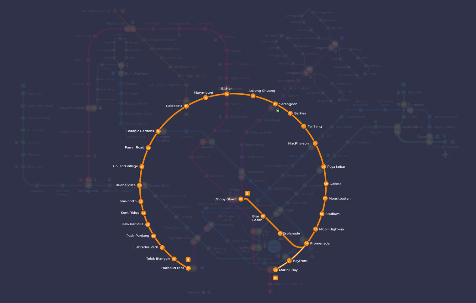
Marymount MRT station at a glance
| Station codes | CC16 |
|---|---|
| Lines | Circle Line |
| Line colour | Yellow line (Circle Line) |
| Interchange | No, single line station |
| Chinese name | 玛丽蒙 |
| Tamil name | மேரிமவுண்ட் |
| Next stations | |
| Train times | Circle Line: first train leaves the terminus at 5:37 AM, last train 11:56 PM Full first and last train guide |
See Marymount on the map. The interactive map opens with this station highlighted, so you can trace the route from where you are.
From Marymount, you can travel directly along the Circle Line in both directions. The neighbouring stations are Bishan to the north-east and Caldecott to the south-west. Bishan is an interchange with the North South Line, giving you straightforward access to the city centre, Jurong East, and destinations along that corridor. Caldecott connects to the Thomson-East Coast Line, opening up routes towards the northern and southern parts of Singapore.
The area around Marymount station is largely residential, characterised by landed housing estates and tree-lined roads. Marymount Road runs close to the station and connects the surrounding neighbourhoods. MacRitchie Reservoir Park, one of Singapore's well-known nature reserves, is reachable from this part of central Singapore, though visitors should expect a walk of some distance through the surrounding roads before reaching the park entrance.
Around Marymount MRT station
Marymount station sits within a quiet, predominantly residential neighbourhood of private housing estates and HDB blocks. The area around the station includes green recreational spaces such as 3G Park @ Shunfu, and everyday amenities like Shunfu Mart are within a short walk. Mount Alvernia Hospital and Raffles Institution add a medical and educational presence to the broader neighbourhood.
| Place | Type | Distance | Why go |
|---|---|---|---|
| 3G Park @ Shunfu | Park | About 100 m (~2 min walk) | A neighbourhood park suitable for outdoor exercise and leisure. |
| Thomson Community Club | Community club | About 450 m (~7 min walk) | A community hub offering courses, activities and local events. |
| Shunfu Mart | Market / hawker centre | About 460 m (~7 min walk) | A local market and hawker centre for everyday groceries and cooked food. |
| Raffles Institution | College | About 510 m (~8 min walk) | A well-known educational institution for pre-university students. |
| Wah Yen | Food centre | About 730 m (~12 min walk) | A food centre serving a range of local cooked dishes. |
| Mount Alvernia Hospital | Hospital | About 740 m (~12 min walk) | A private hospital providing a range of medical and specialist services. |
| Coral Park Magic Tree | Attraction | About 760 m (~12 min walk) | A nature-themed attraction featuring a large sculptural tree structure. |
| Junction 8 | Shopping mall | About 1060 m (~17 min walk) | A suburban shopping mall with retail, dining and supermarket options. |
Places and straight-line distances from OpenStreetMap data (© OpenStreetMap contributors). Actual walking routes may be longer.
How to get to Marymount by MRT
Worked out from the network map. Stop counts are station to station and do not include walking or waiting time.
| From Changi Airport | Take the East West Line from Changi Airport to Paya Lebar (6 stops), then change to the Circle Line from Paya Lebar to Marymount (7 stops). About 13 stops with 1 change. |
|---|---|
| From Orchard | Take the Thomson East Coast Line from Orchard to Caldecott (4 stops), then change to the Circle Line from Caldecott to Marymount (1 stop). About 5 stops with 1 change. |
| From City Hall | Take the North South Line from City Hall to Bishan (8 stops), then change to the Circle Line from Bishan to Marymount (1 stop). About 9 stops with 1 change. |
| From Jurong East | Take the East West Line from Jurong East to Buona Vista (3 stops), then change to the Circle Line from Buona Vista to Marymount (5 stops). About 8 stops with 1 change. |
| From Woodlands | Take the Thomson East Coast Line from Woodlands to Caldecott (7 stops), then change to the Circle Line from Caldecott to Marymount (1 stop). About 8 stops with 1 change. |
| From HarbourFront | Take the Circle Line from HarbourFront to Marymount (12 stops). About 12 stops, no changes. |
Fares from Marymount MRT station
A trip from Marymount to Changi Airport (about 22 km) costs S$2.33 on an adult SimplyGo or EZ-Link card. Fares are charged by distance, so the table below shows the estimated adult card fare from Marymount to the main hubs, the early bird fare for journeys that start before 7.45am on weekdays, and the fare that applies from 26 December 2026.
| To | Distance | Adult card | Before 7.45am | From 26 Dec 2026 |
|---|---|---|---|---|
| Changi Airport | about 22 km, 13 stops | S$2.33 | S$1.83 | S$2.46 |
| Orchard | about 8 km, 5 stops | S$1.75 | S$1.25 | S$1.88 |
| City Hall | about 11 km, 9 stops | S$1.90 | S$1.40 | S$2.03 |
| Raffles Place | about 13 km, 9 stops | S$1.98 | S$1.48 | S$2.11 |
| Jurong East | about 15 km, 8 stops | S$2.07 | S$1.57 | S$2.20 |
| Woodlands | about 16 km, 8 stops | S$2.11 | S$1.61 | S$2.24 |
| HarbourFront | about 17 km, 12 stops | S$2.15 | S$1.65 | S$2.28 |
| Marina Bay | about 13 km, 11 stops | S$1.98 | S$1.48 | S$2.11 |
Estimated from the route distance between stations and the Public Transport Council fare table in force from 27 December 2025. The exact fare can differ by one band. Cash fares are higher. Use the fare calculator for any other journey, or check your fare on the SimplyGo app.
Tips for using Marymount MRT station
- 3G Park @ Shunfu is only about 100 metres from the station, making it the easiest destination to reach on foot.
- Shunfu Mart and Thomson Community Club are both roughly a 7-minute walk away, so they are manageable on foot in comfortable weather.
- Mount Alvernia Hospital and Junction 8 are further away, and taking a bus from the station area may be more comfortable than walking, especially in the midday heat.
- During morning and evening peak hours, trains on the Circle Line can be busy, so allow a little extra time if you are travelling to or from the station during rush hour.
All stations on the Circle Line
In order along the line, with Marymount marked. Stations with their own guide are linked.
| Code | Station | Interchange |
|---|---|---|
| CC1 | Dhoby Ghaut | NS / NE / CC |
| CC2 | Bras Basah | None |
| CC3 | Esplanade | None |
| CC4 | Promenade | CC / DT |
| CC5 | Nicoll Highway | None |
| CC6 | Stadium | None |
| CC7 | Mountbatten | None |
| CC8 | Dakota | None |
| CC9 | Paya Lebar | CC / EW |
| CC10 | MacPherson | CC / DT |
| CC11 | Tai Seng | None |
| CC12 | Bartley | None |
| CC13 | Serangoon | CC / NE |
| CC14 | Lorong Chuan | None |
| CC15 | Bishan | NS / CC |
| CC16 | Marymount (you are here) | None |
| CC17 | Caldecott | CC / TE |
| CC19 | Botanic Gardens | DT / CC |
| CC20 | Farrer Road | None |
| CC21 | Holland Village | None |
| CC22 | Buona Vista | EW / CC |
| CC23 | one-north | None |
| CC24 | Kent Ridge | None |
| CC25 | Haw Par Villa | None |
| CC26 | Pasir Panjang | None |
| CC27 | Labrador Park | None |
| CC28 | Telok Blangah | None |
| CC29 | HarbourFront | CC / NE |
| CC30 | Keppel | None |
| CC31 | Cantonment | None |
| CC32 | Prince Edward Road | None |
Read the full Circle Line guide.
Marymount MRT station: common questions
Which line is Marymount MRT station on?
Marymount is on the Circle Line. Its station code is CC16.
Is Marymount an interchange station?
No. Marymount is served by the Circle Line only. The nearest interchange is shown in the next stations row above.
What time is the first and last train at Marymount?
Times below are for the first and last train leaving the line terminus; trains reach Marymount a few minutes later depending on its position on the line. Circle Line first train 5:37 AM, last train 11:56 PM. Check the operator for holiday changes.
What is near Marymount MRT station?
The station is close to 3G Park @ Shunfu, Shunfu Mart, Thomson Community Club and Raffles Institution, all within approximately 510 metres. Further away, within roughly 700 to 1,100 metres, you will find Mount Alvernia Hospital, Coral Park Magic Tree and Junction 8.
Which is the closest food or market option to Marymount station?
Shunfu Mart is the closest market and hawker centre, at approximately 460 metres, which is roughly a 7-minute walk from the station.
How far is Junction 8 from Marymount MRT station?
Junction 8 is approximately 1,060 metres from Marymount station in a straight line, which is roughly a 17-minute walk, so taking a bus may be more convenient.
How do I get to Marymount from Changi Airport by MRT?
Take the East West Line from Changi Airport to Paya Lebar (6 stops), then change to the Circle Line from Paya Lebar to Marymount (7 stops). About 13 stops with 1 change.
Sources: station codes, line colours and interchanges from the LTA rail system map; operating hours from SMRT and SBS Transit. Last reviewed September 2026.
News and guides mentioning Marymount
- Smart Glasses Voyeur Near Marymount MRT: What Happened 25 Sep 2026
- MRT Map (2011) 11 Aug 2023
Plan the rest of the trip
Every station on the Circle Line is listed on its line guide, with the full route and interchanges. For times, see the first and last train guide, and for the whole network in one view use the interactive Singapore MRT map or the PDF map.