
Boon Keng MRT Station
Boon Keng MRT station is an underground station on the North East Line, with the station code NE9. It lies beneath Serangoon Road in Kallang, a short distance past the junction where Towner Road and Boon Keng Road meet Serangoon Road. Like every station on this line, it is run by SBS Transit.
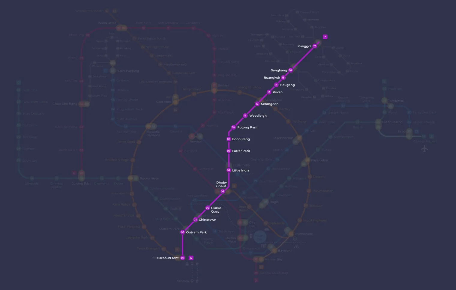
Boon Keng on the North East Line map
Boon Keng MRT station at a glance
| Station codes | NE9 |
|---|---|
| Lines | North East Line |
| Line colour | Purple line (North East Line) |
| Interchange | No, single line station |
| Chinese name | 文庆 |
| Tamil name | பூன் கெங் |
| Opened | 20 June 2003 (23 years ago) |
| Operator | SBS Transit |
| Station type | Underground |
| Platforms | 2 (1 island platform) |
| Address | 900 Serangoon Road, Singapore 328260 |
| Daily ridership | About 23,250 passengers a day (2025) |
| Next stations | |
| Train times | North East Line: first train leaves the terminus at 5:39 AM, last train 11:55 PM Full first and last train guide |
Opening date, operator and ridership figures are LTA data as recorded on Wikipedia.
See Boon Keng on the map. The interactive map opens with this station highlighted, so you can trace the route from where you are.
The station mainly serves the Boon Keng neighbourhood, an estate of HDB flats on the edge of the Kallang River. Most passengers are residents heading to work or school, along with people coming for the local market and hawker centre, worshippers visiting the Central Sikh Temple, and visitors to the nearby hospital. The station takes its name from Lim Boon Keng, after whom the surrounding area is also named.
History of Boon Keng MRT station
Boon Keng was one of sixteen North East Line stations announced in March 1996, and it opened to passengers on 20 June 2003. Building the line towards Potong Pasir meant tunnelling under the Kallang River, Whampoa Canal and a row of Serangoon Road shophouses. Work ran around the clock to limit ground settlement under the shophouses. Part of Whampoa Canal was also rebuilt in reinforced concrete above the tunnels.
Inside Boon Keng MRT station
The station is wheelchair-accessible, with wider fare gates and tactile floor guidance leading from the entrances to the platforms. It is also a designated Civil Defence shelter able to hold at least 7,500 people. In the concourse paid area, look out for Metamorphosis by Lim Poh Teck. This set of enamel panels contrasts old Boon Keng, with boats, trams and fishermen, against today’s high-rise flats and aircraft, and smaller motifs such as a cat and a double-decker bus continue along the station walls.
For most people, Boon Keng MRT station is the way into a local neighbourhood rather than a major shopping or tourist district. Several places are a short walk away:
- Bendemeer Wet Market and Hawker Centre is about two minutes away and is a convenient stop for a meal or groceries.
- Central Sikh Temple is around three minutes on foot.
- Dignity Kitchen, another food centre, is roughly five minutes away.
- Kwong Wai Shiu Hospital is about six minutes away, and its Heritage Gallery is a minute further.
With a longer walk of 15 to 20 minutes, you can reach City Square Mall or the Art Deco shophouses along Balestier and the Sim Kwong Ho shophouses. This makes the station a reasonable starting point for anyone who wants to explore the older streets of the area on foot.
Around Boon Keng MRT station
Boon Keng station sits within a largely residential neighbourhood of HDB flats and older shophouses, with a strong community character. The area is well served by local amenities, including the Bendemeer Food Centre and the Kwong Wai Shiu Hospital nearby. Pockets of heritage interest, such as the Central Sikh Temple, reflect the district's long-established multicultural roots.
| Place | Type | Distance | Why go |
|---|---|---|---|
| Bendemeer Food Center | Food centre | About 150 m (~2 min walk) | Visit Bendemeer Food Centre for a wide variety of local hawker food and drinks. |
| Central Sikh Temple | Place of worship | About 160 m (~3 min walk) | Visit Central Sikh Temple to observe or participate in Sikh worship and community life. |
| Dignity Kitchen | Food centre | About 280 m (~5 min walk) | Visit Dignity Kitchen for affordable hawker meals in a social enterprise setting. |
| Kwong Wai Shiu Hospital | Hospital | About 380 m (~6 min walk) | Visit Kwong Wai Shiu Hospital for medical services in this community hospital. |
| Kwong Wai Shiu Hospital Heritage Gallery | Museum | About 400 m (~7 min walk) | Visit Kwong Wai Shiu Hospital Heritage Gallery to learn about the hospital's history and heritage. |
| Balestier Art Deco shophouses | Attraction | About 990 m (~16 min walk) | Visit Balestier Art Deco shophouses to admire well-preserved pre-war architectural streetscapes. |
| City Square Mall | Shopping mall | About 1070 m (~17 min walk) | Visit City Square Mall for shopping, dining, and everyday retail needs. |
| Sim Kwong Ho shophouses | Attraction | About 1100 m (~18 min walk) | Visit Sim Kwong Ho shophouses to see heritage shophouse architecture in the Balestier area. |
Places and straight-line distances from OpenStreetMap data (© OpenStreetMap contributors). Actual walking routes may be longer.
How to get to Boon Keng by MRT
Worked out from the network map. Stop counts are station to station and do not include walking or waiting time.
| From Changi Airport | Take the East West Line from Changi Airport to Paya Lebar (6 stops), then change to the Circle Line from Paya Lebar to Serangoon (4 stops), then change to the North East Line from Serangoon to Boon Keng (3 stops). About 13 stops with 2 changes. |
|---|---|
| From Orchard | Take the North South Line from Orchard to Dhoby Ghaut (2 stops), then change to the North East Line from Dhoby Ghaut to Boon Keng (3 stops). About 5 stops with 1 change. |
| From City Hall | Take the North South Line from City Hall to Dhoby Ghaut (1 stop), then change to the North East Line from Dhoby Ghaut to Boon Keng (3 stops). About 4 stops with 1 change. |
| From Jurong East | Take the East West Line from Jurong East to Outram Park (8 stops), then change to the North East Line from Outram Park to Boon Keng (6 stops). About 14 stops with 1 change. |
| From Woodlands | Take the Thomson East Coast Line from Woodlands to Stevens (8 stops), then change to the Downtown Line from Stevens to Little India (2 stops), then change to the North East Line from Little India to Boon Keng (2 stops). About 12 stops with 2 changes. |
| From HarbourFront | Take the North East Line from HarbourFront to Boon Keng (7 stops). About 7 stops, no changes. |
Fares from Boon Keng MRT station
A trip from Boon Keng to Changi Airport (about 22 km) costs S$2.33 on an adult SimplyGo or EZ-Link card. Fares are charged by distance, so the table below shows the estimated adult card fare from Boon Keng to the main hubs, the early bird fare for journeys that start before 7.45am on weekdays, and the fare that applies from 26 December 2026.
| To | Distance | Adult card | Before 7.45am | From 26 Dec 2026 |
|---|---|---|---|---|
| Changi Airport | about 22 km, 13 stops | S$2.33 | S$1.83 | S$2.46 |
| Orchard | about 5 km, 5 stops | S$1.49 | S$0.99 | S$1.62 |
| City Hall | about 4 km, 4 stops | S$1.49 | S$0.99 | S$1.62 |
| Raffles Place | about 6 km, 5 stops | S$1.59 | S$1.09 | S$1.72 |
| Jurong East | about 20 km, 14 stops | S$2.27 | S$1.77 | S$2.40 |
| Woodlands | about 23 km, 12 stops | S$2.36 | S$1.86 | S$2.49 |
| HarbourFront | about 9 km, 7 stops | S$1.82 | S$1.32 | S$1.95 |
| Marina Bay | about 7 km, 6 stops | S$1.68 | S$1.18 | S$1.81 |
Estimated from the route distance between stations and the Public Transport Council fare table in force from 27 December 2025. The exact fare can differ by one band. Cash fares are higher. Use the fare calculator for any other journey, or check your fare on the SimplyGo app.
Tips for using Boon Keng MRT station
- Bendemeer Food Centre, Central Sikh Temple, and Dignity Kitchen are all within a short walk of the station and are easy to reach on foot.
- Kwong Wai Shiu Hospital and its Heritage Gallery are a comfortable walk away, though allowing a few extra minutes is advisable if you are unfamiliar with the area.
- The Balestier Art Deco shophouses, City Square Mall, and Sim Kwong Ho shophouses are over a kilometre away by straight-line distance, so taking a bus or riding one stop further on the North East Line may save time.
- During morning and evening peak hours, trains on the North East Line can be busy, so allow extra time if you are travelling with luggage or in a group.
All stations on the North East Line
In order along the line, with Boon Keng marked. Stations with their own guide are linked.
| Code | Station | Interchange |
|---|---|---|
| NE1 | HarbourFront | CC / NE |
| NE3 | Outram Park | TE / EW / NE |
| NE4 | Chinatown | DT / NE |
| NE5 | Clarke Quay | None |
| NE6 | Dhoby Ghaut | NS / NE / CC |
| NE7 | Little India | DT / NE |
| NE8 | Farrer Park | None |
| NE9 | Boon Keng (you are here) | None |
| NE10 | Potong Pasir | None |
| NE11 | Woodleigh | None |
| NE12 | Serangoon | CC / NE |
| NE13 | Kovan | None |
| NE14 | Hougang | None |
| NE15 | Buangkok | None |
| NE16 | Sengkang | NE / STC |
| NE17 | Punggol | NE / PTC |
| NE18 | Punggol Coast | None |
Read the full North East Line guide.
Boon Keng MRT station: common questions
Which line is Boon Keng MRT station on?
Boon Keng is on the North East Line. Its station code is NE9.
Is Boon Keng an interchange station?
No. Boon Keng is served by the North East Line only. The nearest interchange is shown in the next stations row above.
What time is the first and last train at Boon Keng?
Times below are for the first and last train leaving the line terminus; trains reach Boon Keng a few minutes later depending on its position on the line. North East Line first train 5:39 AM, last train 11:55 PM. Check the operator for holiday changes.
What is near Boon Keng MRT station?
Nearby places include Bendemeer Food Centre and Central Sikh Temple within approximately 150 to 160 metres, as well as Dignity Kitchen, Kwong Wai Shiu Hospital, and its Heritage Gallery all within roughly 400 metres. Further afield, at approximately one kilometre or more, you will find the Balestier Art Deco shophouses, City Square Mall, and Sim Kwong Ho shophouses.
Which food centre is closest to Boon Keng station?
Bendemeer Food Centre is the closest, at approximately 150 metres from the station, which is roughly a two-minute walk. Dignity Kitchen is the next nearest food centre, at approximately 280 metres away.
How far is City Square Mall from Boon Keng station?
City Square Mall is approximately 1,070 metres from Boon Keng station in a straight line, which works out to roughly a 17-minute walk. You may prefer to take a bus or the MRT to reach it more quickly.
How do I get to Boon Keng from Changi Airport by MRT?
Take the East West Line from Changi Airport to Paya Lebar (6 stops), then change to the Circle Line from Paya Lebar to Serangoon (4 stops), then change to the North East Line from Serangoon to Boon Keng (3 stops). About 13 stops with 2 changes.
Sources: station codes, line colours and interchanges from the LTA rail system map; operating hours from SMRT and SBS Transit. Last reviewed October 2026.
News and guides mentioning Boon Keng
- シンガポール地下鉄(MRT)路線図 2026(日本語ガイド) 4 Oct 2026
- Playing Loud Music on the Bus? It’ll Cost You Hundreds 24 Sep 2026
- Jaywalkers Fined S$50 Near Boon Keng MRT: What You Need to Know 19 Jul 2026
- North East Line Map 11 Aug 2023
Plan the rest of the trip
Every station on the North East Line is listed on its line guide, with the full route and interchanges. For times, see the first and last train guide, and for the whole network in one view use the interactive Singapore MRT map or the PDF map.
Exits and buses at Boon Keng station
Boon Keng has 3 mapped exits (A to C). The letters match the signs inside the station; the landmark beside each one is the closest mapped place to that entrance, so pick the exit that comes up nearest to where you are going.
- Exit A
- Exit B: closest to Bendemeer Food Center (about 112 m from the entrance)
- Exit C: closest to Central Sikh Temple (about 108 m from the entrance)
Bus stops within 250 m of Boon Keng station
| Bus stop | Stop code | Services | From station |
|---|---|---|---|
| Boon Keng Station/Blk 102 | 60121 | 13, 23, 31, 64, 65, 125, 133, 140, 147, 857, 985, NR6 | 64 m |
| Boon Keng Station/Blk 22 | 60199 | 21, 130, 139 | 174 m |
| Blk 107 | 50349 | 21, 139 | 237 m |
Exits and bus services come from OpenStreetMap and can change when roads or routes are revised; check the board at the stop or the operator app before relying on a service late at night. For the nearest station to where you are now, use the MRT near me finder.
Places to visit from Boon Keng station
See every guide on how to get to Singapore's attractions, hospitals and malls by MRT, with routes and fares from Changi Airport, Orchard and the city.