Last updated . Facts checked against LTA announcements.
MRT stations in Singapore
Find a station easily from this sorted list of all MRT stations in Singapore from A to Z.
Interchange stations appear more than once in the list, once for each line they serve. Click any column heading to sort by station name, line or other available options.
You can also use our interactive MRT Map of Singapore to find and explore stations visually.
The Mass Rapid Transit (MRT) system in a busy city like Singapore can be referred to as a lifeline both for locals and those visiting from abroad. MRT is easy to catch and connects well with all points in the city. Today, we go through the MRT stations in Singapore and tell you which are some of the best stations located at major interchanges for getting around town easily.
Key Points:
Here, we will look at some of the wonders that Singapore MRT stations offer to make your journey through the city as simple and efficient as possible.
Before we dive into Fintech, Popby gives a rundown of some popular MRT stations and discovers little-known features about these places you once pass by more than thrice a week!
Get information about MRT time, ticket prices, and how to plan the journey more conveniently.
Discover how to interchange between different MRT lines easily and make quick connections.
Step outside of the city centre to discover further MRT stations, allowing you access to Singapore on its outskirts and some hidden gems.
Explained: Singapore’s Mrt Network:
The backbone of Singapore’s clean, efficient, and modern public transportation network is the Mass Rapid Transit (MRT) system. The city is so easy to move around and most residents get transport by the network of MRT stations.
Singapore is a country connected through its MRT network that links all major parts of Singapore, making it an efficient mode of travel. The lines are in colour, making it easy for commuters to identify their needed line. Here is an overview of every MRT line in Singapore.
A graphic for the main lines of The Singapore public metro system;
East-West Line (EWL): Stretching from Tuas Link in the west to Pasir Ris in the east, EWL is one of Singapore’s oldest and busiest lines.
North-South Line (NSL): Although shuttling passengers between Jurong East in the west and Marina South Pier in the south, this route is a key artery ferrying commuters from one end of Singapore to another. The red line, the first MRT ever added to the network, of course, I mean the North-South Line (NSL), is the “MRT Red Line,” as shown in red.
North-East Line (NEL): Connects Punggol in the northeast with HarbourFront and passes through some of Singapore’s most important business districts, high-density residential locations, etc.
Circle Line (CC): Circulating town, it links most parts of Singapore and provides fast connectivity to various other lines.
Downtown Line (DT): Bring Bukit Panjang in the northwest and Expo in the east together, this cross-disciplinary line links to key locations such as Chinatown and Little India.
These MRT lines crisscross Singapore, ensuring that commuters can reach important landmarks conveniently, be it work, leisure, or sightseeing.
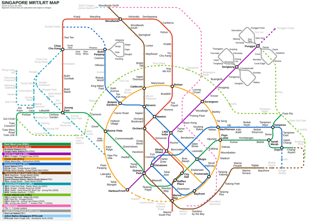
MRT Map
Singapore MRT Map is an essential part of the MRT network in Singapore, while subways only have numbers that can be intimidating at first. This provides everything on the system in one visual that can help people plan their trips to be more effective commuters. MRT stations are very obviously marked on the map, with lines assigned. Passengers can also use the MRT map to identify transfer stations, helping them in planning their trips.
Below is a verifiable example to give you an idea of what the Singapore MRT map looks like.
East-West Line (EW)
North-South Line (NS)
North-East Line (NE)
Circle Line (CC)
Downtown Line (DT)
Tuas Link
Boon Lay
Jurong East
This is a simplified version and not the actual MRT map with all stations for each line.
With digital apps and resources online, it has become easier to find your way around the MRT system. You can also read more in detail on this blog post by Vagabond: Transport Links MRT maps How to plan your next trip Share information about nearby attractions Photographs and screenshots from the application have been provided below.
To get the best out of your Singapore travel, you must understand how the MRT network works and also know in detail about station lines. If you are residing or on holiday here, the MRT passes can get citizens and tourists to respective attractions across this energetic area.
Understanding the MRT network and becoming familiar with the MRT map will greatly enhance your travel experience in Singapore. For locals and visitors alike, using the MRT system enables you to explore the countless attractions and destinations this city has to offer.
MRT Hotspots: Popular Stations Worth Exploring
Singapore’s MRT covers the island well enough that most attractions are within walking distance of a station. A few stations stand out as particularly good starting points, whether you are heading to a street market, a park or a cultural site. Here are some worth knowing about.
Chinatown MRT Station
Chinatown station sits on both the North East Line and the Downtown Line, making it easy to reach from most parts of Singapore. Step out and you are immediately among shophouse-lined streets selling local snacks, souvenirs and everyday goods at Chinatown Street Market. The Sri Mariamman Temple on South Bridge Road is worth a look too: it is Singapore’s oldest Hindu temple and the ornate entrance tower is striking up close.
Dhoby Ghaut MRT Station
Dhoby Ghaut is an interchange for the North South, North East and Circle lines, putting you close to several things worth seeing. Fort Canning Park is a short walk away, with open lawns, historical remnants and shaded paths that make a good break from the heat. The National Museum of Singapore is nearby as well, if you want to spend an hour or two learning about the country’s history.
Shopping on Orchard Road: Orchard MRT Station
Orchard MRT station puts you right on Singapore’s most famous shopping street. You are surrounded by a long stretch of malls, department stores, boutiques and restaurants covering everything from high-end designer labels to affordable everyday fashion. If you want to browse, eat or simply people-watch, this is the place for it.
MRT station
Line codes
What to see nearby
Chinatown
NE4 / DT19
Chinatown Street Market, Sri Mariamman Temple, Buddha Tooth Relic Temple
Dhoby Ghaut
NS24 / NE6 / CC1
Fort Canning Park, National Museum of Singapore
Orchard
NS22 / TE14
Orchard Road shopping, ION Orchard, Ngee Ann City
These are just a few of the popular MRT stations worth knowing about. There is plenty more to explore across the network, and this site will continue covering the stations and areas around them.
MRT Timings and Fares
The MRT generally runs from around 05:30 in the morning until shortly after midnight. Check the official operator websites for exact first and last train times on specific lines, as they vary by station and direction.
Frequent and Reliable Service
Trains run more frequently during weekday morning and evening peak hours, so you rarely wait long when commuting to or from work. During off-peak hours, evenings, weekends and public holidays, frequencies are slightly lower, but the wait is still short on most lines.
MRT Fares: Affordable and Flexible
Singapore uses a distance-based fare system, so you pay more for longer journeys and less for shorter ones. You can pay with an EZ-Link or SimplyGo card, a contactless bank card, or a mobile wallet. Stored-value cards and contactless payment generally work out cheaper than buying a single-trip ticket each time.
If you are visiting Singapore, the Singapore Tourist Pass lets you make unlimited trips on the MRT and most other public transport for 1, 2 or 3 days, which can be good value if you plan to move around a lot. MRT fares are low by international standards, making it one of the most cost-effective ways to get around the city.
Transferring Between MRT Lines
Most interchange stations in Singapore are straightforward to use. Follow the overhead signs on the platform and in the concourse, and you will usually reach the correct line within a few minutes. Knowing your destination station and its line code (for example, NS26 for Orchard on the North South Line) makes it easier to follow the signs without hesitation.
Tips for transferring between MRT lines
Singapore’s network has grown significantly over the years, and most major areas are now served by more than one line. That means you often have a choice of interchange points, and picking the right one can save you time.
Here are some useful tips to help you make smooth connections between MRT lines:
1. Check the MRT Map
Before you travel, look up your route on the MRT map. It shows all the lines and interchange stations together, so you can work out where to switch lines. Spending a minute on this before you leave saves confusion on the day.
2. Follow the In-Station Signage
Once you reach your interchange, the signs will guide you. Every MRT station has clear directional signs pointing to each line and platform. Just follow the signs for your line and you will reach the right platform without doubling back.
3. Time Your Transfer
If you are in a hurry, it helps to have a rough idea of train frequencies on your line. Trains on most lines run every two to five minutes during peak hours, so waits are usually short. You can check live train timings on the MyTransport.SG app if you want to be sure.
4. Use the Right Exit
Many stations have several exits, and picking the right one makes a real difference. Signage inside the station lists nearby landmarks, shopping centres and street names for each exit. Checking this before you head up the escalator saves you walking a long way round outside.
5. Note the Platform You Need
At interchange stations, different lines run from different platforms, and sometimes from entirely separate concourse levels. Check the MRT map or the station signs to confirm which platform serves your line and direction before you tap through the fare gates.
Keep these tips in mind and transferring between lines becomes straightforward. The MRT network covers most of Singapore well, so with a little planning you can get almost anywhere without difficulty.
Advantages
Challenges
Efficient and well-connected MRT network
Potentially crowded during peak hours
Clear signage and directions
Multiple exits at some stations
Frequent train schedules
Potential delays due to maintenance
Free Wi-Fi at most stations
Platform changes or closures for upgrading works
Convenient access to various landmarks and attractions
Large crowds during special events or holidays
MRT Stations Beyond the City Centre
Singapore’s MRT network reaches well beyond the city centre, giving you easy access to nature reserves, cultural neighbourhoods and parks that many visitors never think to explore. If you have a free day and an MRT card, these stations are worth your time.
Beauty World and Bukit Timah
Beauty World station on the Downtown Line puts you close to Bukit Timah Nature Reserve, one of the best patches of primary rainforest in Singapore. The reserve is home to Bukit Timah Hill, the highest point on the island, with several hiking trails ranging from a gentle walk to a steeper climb. You can also spot wildlife and native plants without travelling far from the city at all.
Geylang Serai and Its Malay Heritage
Geylang Serai is a short walk from Paya Lebar station on the East West Line and is one of the best places in Singapore to explore Malay food and culture. The wet market and surrounding shophouses have been a centre of the Malay community for generations. During Ramadan, the area fills with a large bazaar selling traditional snacks, clothing and crafts.
Haw Par Villa
Haw Par Villa station on the Circle Line brings you to one of Singapore’s most unusual attractions: a park filled with sculptures and dioramas depicting Chinese mythology and folklore. The Ten Courts of Hell exhibit alone makes the trip worthwhile. Entry is free, and the park suits anyone curious about Chinese cultural heritage.
Punggol Waterway Park
Punggol station on the North East Line is the starting point for Punggol Waterway Park, reachable via the Punggol LRT. The park runs along a man-made waterway with open green fields, cycling paths and rest areas along the banks. It is a good spot for a relaxed afternoon outdoors, whether you are cycling, jogging or just sitting by the water.
Tiong Bahru: Art Deco and Coffee Culture
Tiong Bahru MRT station (EW17) on the East West Line puts you at the edge of one of Singapore’s most characterful neighbourhoods. The area is well known for its art deco walk-up flats, independent bookshops and a café scene that has built up steadily over many years. Wander the back streets, look out for the painted murals and browse the small boutiques at your own pace.
Sentosa Island: Beaches and Attractions
Sentosa is not served by the MRT directly, but you can reach it via the Sentosa Express monorail from VivoCity, which connects to HarbourFront MRT station (NE1/CC29) on the North East Line and Circle Line. The island has resorts, theme parks and beaches all within a short ride from the city. It makes for a practical half-day or full-day trip if you are already on the southern end of the network.
Heading to the outer parts of Singapore by MRT opens up a different side of the island. Away from the central stations you will find older residential estates, nature parks and heritage areas that are easy to reach without a car.
Lesser-Known MRT Stations Worth Exploring
Some of the most rewarding MRT stops are the ones most visitors skip entirely. Stations away from the well-worn tourist trail tend to sit inside everyday neighbourhoods where the food, markets and street life feel genuinely local. A few stops in the wrong direction can turn out to be the most memorable part of a day out.
Below are some stations that deserve more attention, whether you are after good food, green space or a quieter look at how Singaporeans actually live.
1. Dakota MRT Station
Dakota is on the Circle Line and puts you close to the Joo Chiat and Katong area. Walk out and you are in the middle of Peranakan shophouses, old-school eateries and plenty of local food worth trying, from laksa to kueh. It is one of the more rewarding stations to alight at if you want a genuine taste of heritage Singapore.
2. Labrador Park MRT Station
Labrador Park station on the Circle Line is the stop for Labrador Nature Reserve, a quiet green stretch along the southern coast. You can walk the trails, look out over the sea and spot the remains of Second World War gun batteries still sitting among the trees. It is a good option when you want open space without travelling far from the city centre.
3. Haw Par Villa MRT Station
Get off at Haw Par Villa on the Circle Line and the park of the same name is right there. It is filled with sculptures and dioramas depicting scenes from Chinese mythology and folklore, each carrying a moral story. Entry to the park is free, and it is unlike anything else you will find in Singapore.
4. Punggol MRT Station
Punggol station sits on the North East Line and is the northern terminus, with Punggol LRT connections branching off from here. Punggol Waterway Park is a short walk away, with cycling paths and views along the waterway. The Punggol Settlement area nearby has a cluster of restaurants if you want to eat by the water after.
5. Mount Faber
There is no MRT station called Mount Faber. The nearest stations are HarbourFront on the North East and Circle Lines, from which you can walk or take the cable car up to Mount Faber Park. The hilltop gives you good views over the southern coast and across to Sentosa, and there are restaurants up there if you want to make an evening of it.
6. Kranji MRT Station
Kranji station on the North South Line puts you close to a quieter, greener side of Singapore. The Kranji War Memorial honours the Allied servicemen and women who died defending Singapore in World War II, and it is well worth a visit. The surrounding Kranji Countryside is home to working farms and nature areas where you can take a proper break from the city.
Shopping Hotspots: MRT Stations Near the Best Retail Areas
Some of Singapore’s best shopping is a short walk from an MRT station. From large air-conditioned malls to street markets, the network makes it easy to get around without a car. Here are a few stations worth knowing if shopping is on your list.
1. Orchard Road
Orchard MRT station drops you right in the middle of Singapore’s main shopping belt. The street is lined with large malls selling everything from fast fashion to high-end designer labels. ION Orchard, Ngee Ann City, Mandarin Gallery and Paragon are all within easy walking distance of the station.
2. Marina Bay Sands
Bayfront MRT station, served by both the Circle Line and Downtown Line, gives you direct access to The Shoppes at Marina Bay Sands. The mall has a wide range of international designer boutiques. The architecture of the development is worth a look while you are there.
3. Chinatown
Chinatown MRT station (NE4/DT19) puts you right at the edge of one of Singapore’s most characterful neighbourhoods. Wander the streets around the Chinatown Street Market for traditional handicrafts, antiques and souvenirs, and stop by the Chinatown Complex for local food and everyday goods. The old shophouses are good for browsing even if you are not buying anything.
4. Bugis Street
For affordable streetwear and fashion, get off at Bugis MRT station (EW12/DT14) and head to Bugis Street. There are hundreds of stalls selling clothing, accessories and novelties at keen prices. It can get busy, so going early in the day gives you a quieter browse.
5. VivoCity
VivoCity is one of Singapore’s largest malls and sits right next to HarbourFront MRT station (NE1/CC29). You will find international chains, local shops, a cinema and plenty of dining options, many with views over the water. From here you can also walk to Sentosa via the Sentosa Boardwalk.
These are just a few of the areas you can reach easily by MRT for a good shop. Whether you are after luxury brands, local souvenirs or budget fashion, there is something across the network to suit you.
MRT Station
Shopping Destinations
Orchard
ION Orchard, Mandarin Gallery, Ngee Ann City, Paragon
Bayfront
Marina Bay Sands
Chinatown
Chinatown Street Market, Chinatown Complex
Bugis
Bugis Street
HarbourFront
VivoCity
Other Public Transportation Options
The MRT covers most of Singapore well, but buses fill in the gaps and are worth using alongside the rail network. The same EZ-Link or contactless payment you use on the MRT works on buses too, so switching between the two is straightforward.
Bus Network: Extensive Coverage, Flexible Routes
Buses cover parts of Singapore that the MRT does not reach, making them a practical complement to the rail network. Routes are frequent and spread across the whole island, so there is almost always a bus stop within walking distance of where you need to go.
Wider coverage: Buses serve residential estates, industrial areas and other spots where no MRT station exists nearby, so you can get much closer to your actual destination.
Lower fares: Bus fares are generally cheaper than MRT fares, which makes them a popular choice for shorter trips and everyday commuting.
Apps such as MyTransport.SG and Google Maps show real-time bus arrival times and can plan door-to-door routes combining buses and MRT. Enter your start point and destination and the app will suggest the most practical combination.
Commuter Rail: Cross-Border Connectivity
Beyond the MRT, Singapore has rail links that extend across the Causeway and Second Link into Malaysia. The East West Line and North South Line connect to these cross-border services, giving commuters direct access to Johor Bahru and beyond.
Regional reach: Cross-border rail services link Singapore to towns in southern Malaysia, useful for commuters who live or work on both sides of the border.
Interchange points: Stations where these services connect with the MRT allow you to transfer between networks in one place rather than making separate trips.
Express options: Some cross-border services run faster than local stopping trains, cutting journey times for longer trips.
Cross-border fares are separate from your MRT fare, so make sure you have the right ticket or travel card before boarding. Your EZ-Link or SimplyGo card may not be accepted on all services, so check in advance.
Wrapping Up
Singapore’s MRT network covers the island well, and knowing your stations makes getting around much simpler. From Farrer Park on the North East Line to Bayfront on the Circle and Downtown lines, most places you want to reach are a short walk from a station.
Use this page as a reference when planning your trips. Check the station list and map to find the right line, and pay your fare with an EZ-Link card, SimplyGo card or contactless bank card.
The network stretches across the city, so whether you are heading east towards Pasir Ris or west to Boon Lay, there is a station close by. Lines are still expanding, with remaining Thomson-East Coast Line stages, the Downtown Line 3 Extension, and the Jurong Region Line all due to open over the next few years.
Frequently asked questions
How many MRT stations are there in Singapore?
Singapore has six MRT lines and three LRT lines. Counting each line separately, the North South Line has 27 stations, the East West Line 35 (including the Changi Airport branch), the North East Line 17, the Circle Line 33, the Downtown Line 35 and the Thomson-East Coast Line 27. Many stations are interchanges, so the number of separate stations is lower, and every open one is in the A to Z list on this page.
Which MRT lines does SMRT operate and which does SBS Transit operate?
SMRT operates the North South Line, East West Line, Circle Line, Thomson-East Coast Line and Bukit Panjang LRT. SBS Transit runs the North East Line, Downtown Line, Sengkang LRT and Punggol LRT.
Is the Circle Line now a complete loop?
Yes, the Circle Line became a full loop on 12 July 2026 when Stage 6 opened with three new stations: Keppel CC30, Cantonment CC31 and Prince Edward Road CC32. These stations connect HarbourFront to Marina Bay, completing the circuit at around 39.5 km and 33 stations.
What new MRT stations have opened recently in Singapore?
Several stations have opened since late 2024. Punggol Coast NE18 on the North East Line opened 10 December 2024, Hume DT4 on the Downtown Line opened 28 February 2025, and the three Circle Line Stage 6 stations opened 12 July 2026. The Thomson-East Coast Line Stage 4 stations from Tanjong Rhu to Bayshore also opened 23 June 2024.
Are there any MRT stations that are built but not yet open to the public?
Yes, several stations exist but are not yet serving passengers. On the Thomson-East Coast Line, Mount Pleasant TE10, Marina South TE21 and Founders' Memorial TE22A are built and trains pass through them, but they have not opened. The Downtown Line 3 Extension stations Xilin DT36 and Sungei Bedok DT37, along with Thomson-East Coast Line Stage 5 stations Bedok South TE30 and Sungei Bedok TE31, are due in the second half of 2026 but have not opened yet.
Each guide lists the station codes, the lines and interchanges, the next stations in both directions, first and last train times, and a link that opens the interactive map with that station highlighted.