
Farrer Park MRT Station
Farrer Park MRT station is an underground station on the North East Line, carrying the code NE8. It sits between Rangoon Road and Gloucester Road, on the boundary between the Kallang and Rochor planning areas, and lies directly beneath the Connexion building, which houses Farrer Park Hospital and One Farrer Hotel. Services on the line are run by SBS Transit.
Farrer Park on the North East Line map
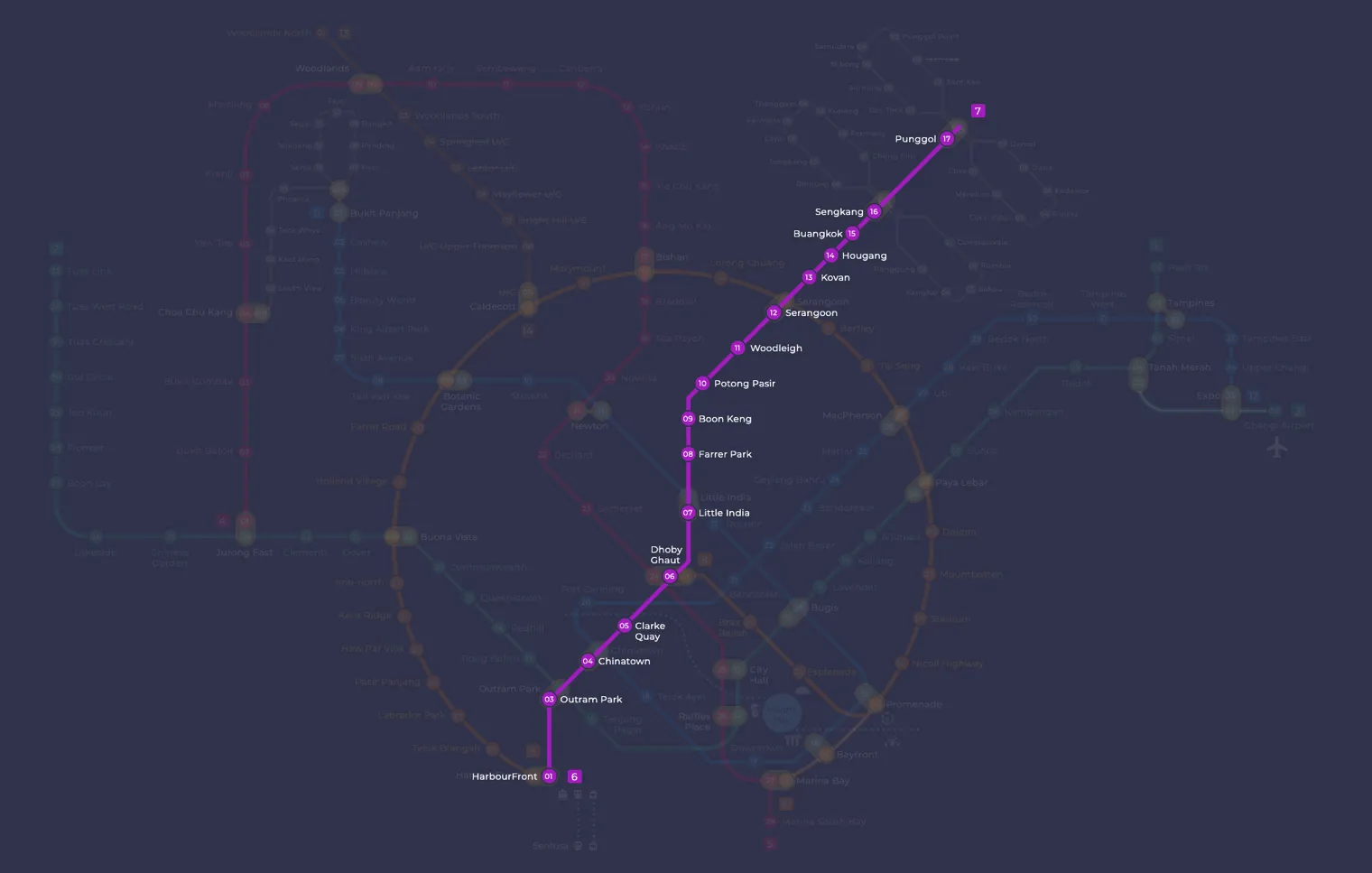
Farrer Park MRT station at a glance
| Station codes | NE8 |
|---|---|
| Lines | North East Line |
| Line colour | Purple line (North East Line) |
| Interchange | No, single line station |
| Chinese name | 花拉公园 |
| Tamil name | ஃபேரர் பார்க் |
| Opened | 20 June 2003 (23 years ago) |
| Operator | SBS Transit |
| Station type | Underground |
| Platforms | 2 (1 island platform) |
| Address | 250 Race Course Road, Singapore 218703 |
| Daily ridership | About 2,024 passengers a day (2024) |
| Next stations | |
| Train times | North East Line: first train leaves the terminus at 5:39 AM, last train 11:55 PM Full first and last train guide |
Opening date, operator and ridership figures are LTA data as recorded on Wikipedia.
See Farrer Park on the map. The interactive map opens with this station highlighted, so you can trace the route from where you are.
The station is one of two that serve Little India, so many passengers are heading to the shops, eateries and places of worship in the district. Others come for medical appointments at the hospital upstairs, or to shop at the large malls a short walk away. Local residents and pupils also use it, as the station is close to Farrer Park Primary School, Masjid Angullia and Sri Srinivasa Perumal Temple.
History of Farrer Park MRT station
The station opened on 20 June 2003, on the same day as the rest of the North East Line. While the tunnels were being dug nearby, the Foochow Methodist Church developed cracks, and its congregation moved temporarily to the nearby Rex Cinema while engineers reinforced the building’s foundations. In 2011, because passengers often mixed up the name with Farrer Road on the Circle Line, there was a proposal to rename the station “New World” or “Kitchener”.
Inside Farrer Park MRT station
Farrer Park MRT station has eight exits, more than any other station on the North East Line, so it is worth checking which one is closest to where you are going. Tactile guidance tiles lead visually impaired passengers from the entrances to the platforms, and wider fare gates make entry easier for wheelchair users. Like most stations on the line, it is a designated Civil Defence shelter built to hold at least 7,500 people. Look out for Rhythmic Exuberance by Poh Siew Wah, a set of vitreous enamel murals showing football, swimming, athletics and other sports, which recalls the area’s past as a sports ground before the Second World War.
For most visitors, Farrer Park MRT station is a practical starting point for shopping and sightseeing in and around Little India. Useful places within walking distance include:
- Farrer Park Hospital, directly above the station and about a minute’s walk away
- Mustafa Centre, the well known shopping centre, roughly five minutes on foot
- City Square Mall, also about five minutes away
- Little India, around nine minutes’ walk, with the Indian Heritage Centre a little further on
Residents use the station for daily commuting and errands, while visitors often combine a trip to Mustafa Centre or City Square Mall with a walk through the heritage streets of Little India.
Around Farrer Park MRT station
Farrer Park station sits in a mixed residential and commercial neighbourhood with a strong medical cluster, including Farrer Park Hospital and StarMed Specialist Centre just steps away. The area borders the Little India district, giving it a lively multicultural character with a wide range of shops, eateries and cultural attractions within walking distance. City Square Mall and Mustafa Centre are both within a short walk, making the surroundings convenient for everyday shopping.
| Place | Type | Distance | Why go |
|---|---|---|---|
| Farrer Park Hospital | Hospital | About 20 m (~1 min walk) | Visit for a wide range of private specialist and inpatient medical services. |
| StarMed Specialist Centre | Hospital | About 60 m (~1 min walk) | Visit for specialist outpatient consultations and medical care. |
| Mustafa Centre | Shopping mall | About 290 m (~5 min walk) | Visit for round-the-clock shopping across a large range of goods and groceries. |
| City Square Mall | Shopping mall | About 300 m (~5 min walk) | Visit for mainstream retail, dining and everyday shopping under one roof. |
| Little India | Attraction | About 540 m (~9 min walk) | Visit to explore the cultural streets, shops and eateries of the Little India district. |
| House of Tan Teng Niah | Attraction | About 700 m (~11 min walk) | Visit to see a well-preserved, colourful heritage building in the Little India area. |
| Indian Heritage Centre | Museum | About 790 m (~13 min walk) | Visit to learn about the history and culture of Indian communities in Singapore. |
| Tekka Centre | Shopping mall | About 810 m (~13 min walk) | Visit for a wet market, hawker food and everyday goods in a traditional setting. |
Places and straight-line distances from OpenStreetMap data (© OpenStreetMap contributors). Actual walking routes may be longer.
How to get to Farrer Park by MRT
Worked out from the network map. Stop counts are station to station and do not include walking or waiting time.
| From Changi Airport | Take the East West Line from Changi Airport to Bugis (10 stops), then change to the Downtown Line from Bugis to Little India (2 stops), then change to the North East Line from Little India to Farrer Park (1 stop). About 13 stops with 2 changes. |
|---|---|
| From Orchard | Take the North South Line from Orchard to Dhoby Ghaut (2 stops), then change to the North East Line from Dhoby Ghaut to Farrer Park (2 stops). About 4 stops with 1 change. |
| From City Hall | Take the North South Line from City Hall to Dhoby Ghaut (1 stop), then change to the North East Line from Dhoby Ghaut to Farrer Park (2 stops). About 3 stops with 1 change. |
| From Jurong East | Take the East West Line from Jurong East to Outram Park (8 stops), then change to the North East Line from Outram Park to Farrer Park (5 stops). About 13 stops with 1 change. |
| From Woodlands | Take the Thomson East Coast Line from Woodlands to Stevens (8 stops), then change to the Downtown Line from Stevens to Little India (2 stops), then change to the North East Line from Little India to Farrer Park (1 stop). About 11 stops with 2 changes. |
| From HarbourFront | Take the North East Line from HarbourFront to Farrer Park (6 stops). About 6 stops, no changes. |
Fares from Farrer Park MRT station
A trip from Farrer Park to Changi Airport (about 20 km) costs S$2.30 on an adult SimplyGo or EZ-Link card. Fares are charged by distance, so the table below shows the estimated adult card fare from Farrer Park to the main hubs, the early bird fare for journeys that start before 7.45am on weekdays, and the fare that applies from 26 December 2026.
| To | Distance | Adult card | Before 7.45am | From 26 Dec 2026 |
|---|---|---|---|---|
| Changi Airport | about 20 km, 13 stops | S$2.30 | S$1.80 | S$2.43 |
| Orchard | about 4 km, 4 stops | S$1.38 | S$0.88 | S$1.51 |
| City Hall | about 3 km, 3 stops | S$1.28 | S$0.78 | S$1.40 |
| Raffles Place | about 4 km, 4 stops | S$1.49 | S$0.99 | S$1.62 |
| Jurong East | about 18 km, 13 stops | S$2.24 | S$1.74 | S$2.37 |
| Woodlands | about 22 km, 11 stops | S$2.33 | S$1.83 | S$2.46 |
| HarbourFront | about 8 km, 6 stops | S$1.75 | S$1.25 | S$1.88 |
| Marina Bay | about 5 km, 5 stops | S$1.59 | S$1.09 | S$1.72 |
Estimated from the route distance between stations and the Public Transport Council fare table in force from 27 December 2025. The exact fare can differ by one band. Cash fares are higher. Use the fare calculator for any other journey, or check your fare on the SimplyGo app.
Tips for using Farrer Park MRT station
- Farrer Park Hospital and StarMed Specialist Centre are within a one-minute walk of the station, making them easy to reach on foot without any planning needed.
- Mustafa Centre and City Square Mall are both roughly a five-minute walk away and are straightforward to reach on foot, though allow a little extra time if you are unfamiliar with the streets.
- Little India, the House of Tan Teng Niah, the Indian Heritage Centre and Tekka Centre are all between nine and thirteen minutes on foot, so consider taking a bus if you prefer a shorter journey or the weather is unfavourable.
- The area can be particularly busy on weekends and during festive periods, so allow extra time when travelling to or from the station at peak hours.
All stations on the North East Line
In order along the line, with Farrer Park marked. Stations with their own guide are linked.
| Code | Station | Interchange |
|---|---|---|
| NE1 | HarbourFront | CC / NE |
| NE3 | Outram Park | TE / EW / NE |
| NE4 | Chinatown | DT / NE |
| NE5 | Clarke Quay | None |
| NE6 | Dhoby Ghaut | NS / NE / CC |
| NE7 | Little India | DT / NE |
| NE8 | Farrer Park (you are here) | None |
| NE9 | Boon Keng | None |
| NE10 | Potong Pasir | None |
| NE11 | Woodleigh | None |
| NE12 | Serangoon | CC / NE |
| NE13 | Kovan | None |
| NE14 | Hougang | None |
| NE15 | Buangkok | None |
| NE16 | Sengkang | NE / STC |
| NE17 | Punggol | NE / PTC |
| NE18 | Punggol Coast | None |
Read the full North East Line guide.
Farrer Park MRT station: common questions
Which line is Farrer Park MRT station on?
Farrer Park is on the North East Line. Its station code is NE8.
Is Farrer Park an interchange station?
No. Farrer Park is served by the North East Line only. The nearest interchange is shown in the next stations row above.
What time is the first and last train at Farrer Park?
Times below are for the first and last train leaving the line terminus; trains reach Farrer Park a few minutes later depending on its position on the line. North East Line first train 5:39 AM, last train 11:55 PM. Check the operator for holiday changes.
What is near Farrer Park MRT station?
The station is surrounded by medical facilities, shopping options and cultural attractions, including Farrer Park Hospital and StarMed Specialist Centre within one minute on foot, Mustafa Centre and City Square Mall at roughly five minutes, and the Little India district at approximately nine minutes walk.
Which shopping mall is closest to Farrer Park MRT station?
Both Mustafa Centre and City Square Mall are the closest malls, each approximately 290 to 300 metres away, which is roughly a five-minute walk.
How far is Tekka Centre from Farrer Park MRT station?
Tekka Centre is approximately 810 metres from the station, which is roughly a thirteen-minute walk.
How do I get to Farrer Park from Changi Airport by MRT?
Take the East West Line from Changi Airport to Bugis (10 stops), then change to the Downtown Line from Bugis to Little India (2 stops), then change to the North East Line from Little India to Farrer Park (1 stop). About 13 stops with 2 changes.
Sources: station codes, line colours and interchanges from the LTA rail system map; operating hours from SMRT and SBS Transit. Last reviewed October 2026.
News and guides mentioning Farrer Park
- シンガポール地下鉄(MRT)路線図 2026(日本語ガイド) 4 Oct 2026
- Power Bank Fire at Little India MRT Station 14 Sep 2026
- Singapore MRT Art in Transit Programme Explained 13 Aug 2026
- Power Bank Fire at Buangkok MRT: What Happened 31 Jul 2026
Plan the rest of the trip
Every station on the North East Line is listed on its line guide, with the full route and interchanges. For times, see the first and last train guide, and for the whole network in one view use the interactive Singapore MRT map or the PDF map.
Exits and buses at Farrer Park station
Farrer Park has 9 mapped exits (A to I). The letters match the signs inside the station; the landmark beside each one is the closest mapped place to that entrance, so pick the exit that comes up nearest to where you are going.
- Exit A: closest to StarMed Specialist Centre (about 24 m from the entrance)
- Exit B
- Exit C: closest to Farrer Park Hospital (about 111 m from the entrance)
- Exit D: closest to Farrer Park Hospital (about 117 m from the entrance)
- Exit E
- Exit F
- Exit G: closest to City Green (about 74 m from the entrance)
- Exit H: closest to City Green (about 23 m from the entrance)
- Exit I: closest to Malaysia Chiak! (about 22 m from the entrance)
Bus stops within 250 m of Farrer Park station
| Bus stop | Stop code | Services | From station |
|---|---|---|---|
| Farrer Park Station Exit A | 50251 | 131, 141 | 78 m |
| Opposite Farrer Park Station | 50259 | 141 | 105 m |
| Farrer Park Station Exit D | 50279 | 141 | 174 m |
| After Farrer Park Station Exit G | 07211 | 21, 23, 64, 65, 67, 125, 130, 139, 141, 147, 857, NR6 | 234 m |
Exits and bus services come from OpenStreetMap and can change when roads or routes are revised; check the board at the stop or the operator app before relying on a service late at night. For the nearest station to where you are now, use the MRT near me finder.
Places to visit from Farrer Park station
Step-by-step guides with the exit to use, the walk and the fare:
See every guide on how to get to Singapore's attractions, hospitals and malls by MRT, with routes and fares from Changi Airport, Orchard and the city.
Hungry? See food near Farrer Park MRT: hawker centres, food courts and cafes with walking times.