
Marina Bay MRT Station
Marina Bay MRT station is an interchange station serving the Circle Line (Marina Bay extension) and the Thomson East Coast Line, with station codes CE2 and TE20. It sits at the heart of the Marina Bay financial and business district, one of Singapore's most prominent commercial zones, surrounded by office towers, hotels, and large-scale waterfront developments. The station connects this dense, largely non-residential precinct to the wider MRT network.
Marina Bay on the Circle Line (Marina Bay extension) map
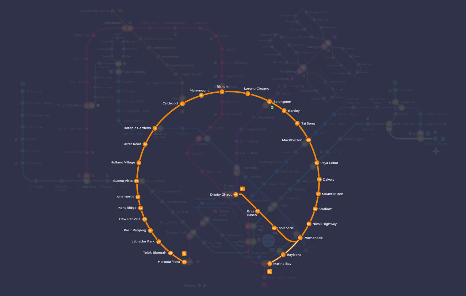
Marina Bay MRT station at a glance
| Station codes | CE2TE20NS27 |
|---|---|
| Lines | Circle Line (Marina Bay extension) Thomson East Coast Line North South Line |
| Line colour | Yellow line (Circle Line (Marina Bay extension)) Brown line (Thomson East Coast Line) Red line (North South Line) |
| Interchange | Yes, change between 3 lines here |
| Chinese name | 滨海湾 |
| Tamil name | மரீனா பே |
| Next stations | |
| Train times | Circle Line (Marina Bay extension): first train leaves the terminus at 5:37 AM, last train 11:56 PM Thomson East Coast Line: first train leaves the terminus at 5:36 AM, last train 11:42 PM North South Line: first train leaves the terminus at 5:16 AM, last train 11:48 PM Full first and last train guide |
See Marina Bay on the map. The interactive map opens with this station highlighted, so you can trace the route from where you are.
Passengers can change between the Circle Line and the Thomson East Coast Line here without leaving the paid zone. On the Circle Line, the neighbouring station towards the waterfront attractions is Bayfront, while the Thomson East Coast Line runs to Marina South in one direction and Shenton Way in the other, giving direct access to the Central Business District and, further along, to residential and commercial areas stretching up the eastern and northern parts of Singapore.
The station is within walking distance of the Marina Bay waterfront promenade, where visitors can take in views across the bay towards the city skyline. The surrounding area is home to several large hotels and the Marina Bay financial centre towers, making it a practical stop for business travellers and visitors exploring the waterfront precinct. The general neighbourhood is open, modern, and oriented around offices, conventions, and large-scale public spaces.
Around Marina Bay MRT station
Marina Bay station sits at the heart of Singapore's central business district, surrounded by major office towers, hotels and financial institutions. The area draws a largely professional crowd on weekdays, with leisure visitors heading to destinations such as The Shoppes at Marina Bay Sands and Marina One. Cultural attractions including the Red Dot Design Museum and Singapore Chinese Cultural Centre add variety to this otherwise corporate precinct.
| Place | Type | Distance | Why go |
|---|---|---|---|
| Malaysia Chiak! | Food centre | About 300 m (~5 min walk) | Visit for a range of local and Malaysian food stalls in a food centre setting. |
| Marina One | Shopping mall | About 330 m (~5 min walk) | Visit for shopping, dining and office retail in a large mixed-use development. |
| Red Dot Design Museum | Museum | About 520 m (~8 min walk) | Visit to explore Singapore's design heritage and rotating design exhibitions. |
| Singapore Chinese Cultural Centre | Museum | About 650 m (~11 min walk) | Visit to learn about Chinese culture, history and the arts in Singapore. |
| OUE Downtown | Shopping mall | About 770 m (~13 min walk) | Visit for retail and dining options within a central business district development. |
| Lau Pa Sat | Food centre | About 780 m (~13 min walk) | Visit for a wide selection of hawker food in a historic cast-iron pavilion. |
| The Shoppes at Marina Bay Sands | Shopping mall | About 1030 m (~17 min walk) | Visit for upscale shopping, dining and waterfront leisure at Marina Bay Sands. |
| Nagore Durgha Indian Muslim Heritage Centre | Museum | About 1060 m (~17 min walk) | Visit to discover the history of Indian Muslim heritage and culture in Singapore. |
Places and straight-line distances from OpenStreetMap data (© OpenStreetMap contributors). Actual walking routes may be longer.
How to get to Marina Bay by MRT
Worked out from the network map. Stop counts are station to station and do not include walking or waiting time.
| From Changi Airport | Take the East West Line from Changi Airport to Raffles Place (12 stops), then change to the North South Line from Raffles Place to Marina Bay (1 stop). About 13 stops with 1 change. |
|---|---|
| From Orchard | Take the Thomson East Coast Line from Orchard to Marina Bay (6 stops). About 6 stops, no changes. |
| From City Hall | Take the East West Line from City Hall to Raffles Place (1 stop), then change to the North South Line from Raffles Place to Marina Bay (1 stop). About 2 stops with 1 change. |
| From Jurong East | Take the East West Line from Jurong East to Raffles Place (10 stops), then change to the North South Line from Raffles Place to Marina Bay (1 stop). About 11 stops with 1 change. |
| From Woodlands | Take the Thomson East Coast Line from Woodlands to Marina Bay (17 stops). About 17 stops, no changes. |
| From HarbourFront | Take the Circle Line from HarbourFront to Marina Bay (4 stops). About 4 stops, no changes. |
Fares from Marina Bay MRT station
A trip from Marina Bay to Changi Airport (about 21 km) costs S$2.33 on an adult SimplyGo or EZ-Link card. Fares are charged by distance, so the table below shows the estimated adult card fare from Marina Bay to the main hubs, the early bird fare for journeys that start before 7.45am on weekdays, and the fare that applies from 26 December 2026.
| To | Distance | Adult card | Before 7.45am | From 26 Dec 2026 |
|---|---|---|---|---|
| Changi Airport | about 21 km, 13 stops | S$2.33 | S$1.83 | S$2.46 |
| Orchard | about 5 km, 6 stops | S$1.49 | S$0.99 | S$1.62 |
| City Hall | about 2 km, 2 stops | S$1.28 | S$0.78 | S$1.40 |
| Raffles Place | about 1 km, 1 stop | S$1.28 | S$0.78 | S$1.40 |
| Jurong East | about 16 km, 11 stops | S$2.11 | S$1.61 | S$2.24 |
| Woodlands | about 26 km, 17 stops | S$2.42 | S$1.92 | S$2.55 |
| HarbourFront | about 4 km, 4 stops | S$1.49 | S$0.99 | S$1.62 |
Estimated from the route distance between stations and the Public Transport Council fare table in force from 27 December 2025. The exact fare can differ by one band. Cash fares are higher. Use the fare calculator for any other journey, or check your fare on the SimplyGo app.
Tips for using Marina Bay MRT station
- Marina Bay is an interchange station between the Circle Line and Thomson East Coast Line, so check which line gets you closest to your onward destination before boarding.
- Malaysia Chiak! and Marina One are both roughly a five-minute walk and are among the most convenient options for a quick meal or errand near the station.
- Lau Pa Sat and OUE Downtown are around a 13-minute walk, so allow extra time to reach them, particularly during the midday heat.
- The Shoppes at Marina Bay Sands and the Nagore Durgha Indian Muslim Heritage Centre are over one kilometre away by straight line, so consider taking a connecting train or other surface transport rather than walking.
All stations on the Thomson East Coast Line
In order along the line, with Marina Bay marked. Stations with their own guide are linked.
| Code | Station | Interchange |
|---|---|---|
| TE1 | Woodlands North | None |
| TE2 | Woodlands | NS / TE |
| TE3 | Woodlands South | None |
| TE4 | Springleaf | None |
| TE5 | Lentor | None |
| TE6 | Mayflower | None |
| TE7 | Bright Hill | None |
| TE8 | Upper Thomson | None |
| TE9 | Caldecott | CC / TE |
| TE11 | Stevens | DT / TE |
| TE12 | Napier | None |
| TE13 | Orchard Boulevard | None |
| TE14 | Orchard | TE / NS |
| TE15 | Great World | None |
| TE16 | Havelock | None |
| TE17 | Outram Park | TE / EW / NE |
| TE18 | Maxwell | None |
| TE19 | Shenton Way | None |
| TE20 | Marina Bay (you are here) | CE / TE / NS |
| TE22 | Gardens by the Bay | None |
| TE23 | Tanjong Rhu | None |
| TE24 | Katong Park | None |
| TE25 | Tanjong Katong | None |
| TE26 | Marine Parade | None |
| TE27 | Marine Terrace | None |
| TE28 | Siglap | None |
| TE29 | Bayshore | None |
Read the full Thomson East Coast Line guide.
All stations on the North South Line
In order along the line, with Marina Bay marked. Stations with their own guide are linked.
| Code | Station | Interchange |
|---|---|---|
| NS1 | Jurong East | EW / NS |
| NS2 | Bukit Batok | None |
| NS3 | Bukit Gombak | None |
| NS4 | Choa Chu Kang | NS / BP |
| NS5 | Yew Tee | None |
| NS7 | Kranji | None |
| NS8 | Marsiling | None |
| NS9 | Woodlands | NS / TE |
| NS10 | Admiralty | None |
| NS11 | Sembawang | None |
| NS12 | Canberra | None |
| NS13 | Yishun | None |
| NS14 | Khatib | None |
| NS15 | Yio Chu Kang | None |
| NS16 | Ang Mo Kio | None |
| NS17 | Bishan | NS / CC |
| NS18 | Braddell | None |
| NS19 | Toa Payoh | None |
| NS20 | Novena | None |
| NS21 | Newton | NS / DT |
| NS22 | Orchard | TE / NS |
| NS23 | Somerset | None |
| NS24 | Dhoby Ghaut | NS / NE / CC |
| NS25 | City Hall | EW / NS |
| NS26 | Raffles Place | NS / EW |
| NS27 | Marina Bay (you are here) | CE / TE / NS |
| NS28 | Marina South Pier | None |
Read the full North South Line guide.
Marina Bay MRT station: common questions
Which line is Marina Bay MRT station on?
Marina Bay is on the Circle Line (Marina Bay extension) and the Thomson East Coast Line and the North South Line. Its station codes are CE2 and TE20 and NS27.
Is Marina Bay an interchange station?
Yes. You can change between the Circle Line (Marina Bay extension) and the Thomson East Coast Line and the North South Line inside the station without leaving the paid area.
What time is the first and last train at Marina Bay?
Times below are for the first and last train leaving the line terminus; trains reach Marina Bay a few minutes later depending on its position on the line. Circle Line (Marina Bay extension) first train 5:37 AM, last train 11:56 PM. Thomson East Coast Line first train 5:36 AM, last train 11:42 PM. North South Line first train 5:16 AM, last train 11:48 PM. Check the operator for holiday changes.
What is near Marina Bay MRT station?
Nearby places include Marina One shopping mall, Malaysia Chiak! food centre, the Red Dot Design Museum, Singapore Chinese Cultural Centre, Lau Pa Sat, OUE Downtown, The Shoppes at Marina Bay Sands and the Nagore Durgha Indian Muslim Heritage Centre. The area is primarily a business and financial district with a mix of dining, retail and cultural attractions.
Which mall or food centre is closest to Marina Bay MRT station?
Malaysia Chiak! food centre is the closest at approximately 300 metres, roughly a five-minute walk. Marina One shopping mall is just slightly further at approximately 330 metres, also around a five-minute walk.
How far is Lau Pa Sat from Marina Bay MRT station?
Lau Pa Sat is approximately 780 metres from Marina Bay station in a straight line, which is roughly a 13-minute walk. Allow additional time if you are travelling during peak hours.
How do I get to Marina Bay from Changi Airport by MRT?
Take the East West Line from Changi Airport to Raffles Place (12 stops), then change to the North South Line from Raffles Place to Marina Bay (1 stop). About 13 stops with 1 change.
Sources: station codes, line colours and interchanges from the LTA rail system map; operating hours from SMRT and SBS Transit. Last reviewed September 2026.
News and guides mentioning Marina Bay
- Labrador Park MRT: SMRT Staff Help Injured Cyclist 19 Oct 2026
- Chain collision of 3 buses in Yishun injures 5 riders 16 Oct 2026
- Autonomous bus trials halted: what LTA is testing instead 13 Oct 2026
- Straits Times audio news now at 68 SMRT stations 8 Oct 2026
Plan the rest of the trip
Every station on the Circle Line (Marina Bay extension) and the Thomson East Coast Line is listed on its line guide, with the full route and interchanges. For times, see the first and last train guide, and for the whole network in one view use the interactive Singapore MRT map or the PDF map.