
Clarke Quay MRT Station
Clarke Quay MRT station is served by the North East Line and carries the station code NE5. It sits in the heart of the city centre, close to the Singapore River, and primarily serves the Clarke Quay entertainment and dining district. The surrounding area is a mix of riverside bars, restaurants, and commercial buildings, drawing visitors and workers throughout the day and into the evening.
Clarke Quay on the North East Line map
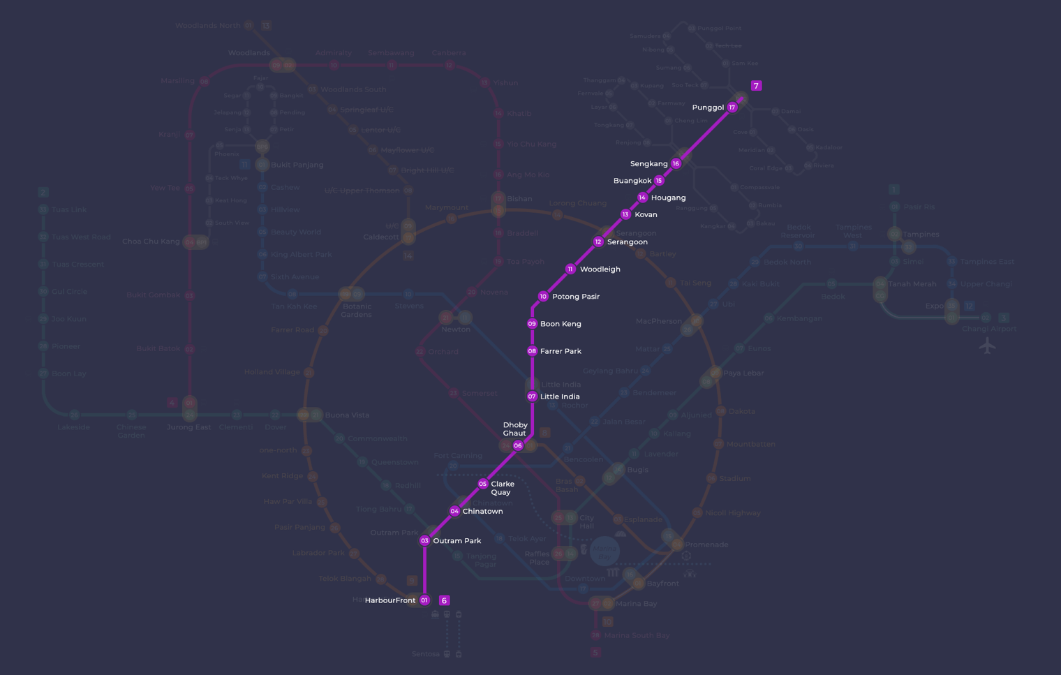
Clarke Quay MRT station at a glance
| Station codes | NE5 |
|---|---|
| Lines | North East Line |
| Line colour | Purple line (North East Line) |
| Interchange | No, single line station |
| Chinese name | 克拉码头 |
| Tamil name | கிளார்க் கீ |
| Next stations | |
| Train times | North East Line: first train leaves the terminus at 5:39 AM, last train 11:55 PM Full first and last train guide |
See Clarke Quay on the map. The interactive map opens with this station highlighted, so you can trace the route from where you are.
From Clarke Quay, the North East Line connects you directly to neighbouring Chinatown station (NE4), where you can transfer to the Downtown Line, and to Dhoby Ghaut station (NE6), which is a major interchange offering connections to the Circle Line and North South Line. There is no interchange at Clarke Quay itself, but these two neighbouring stations give you broad access to much of the rest of the rail network within just one stop in either direction.
Clarke Quay itself is the most well known landmark within walking distance, a riverside cluster of conservation shophouses converted into restaurants and bars along the Singapore River. The river runs directly alongside the station, and the waterfront promenade is easily reachable on foot. The general neighbourhood is lively at most hours and is primarily geared towards leisure and dining, making this station a practical stop for anyone heading out to the riverside area of the city centre.
Around Clarke Quay MRT station
Clarke Quay station sits in a lively riverside entertainment and cultural district along the Singapore River. The area is dominated by dining, nightlife and shopping, with Clarke Quay Central mall just steps away. Several museums and galleries, including the Asian Civilisations Museum and National Gallery Singapore, are within walking distance, giving the neighbourhood a strong arts and heritage character.
| Place | Type | Distance | Why go |
|---|---|---|---|
| Clarke Quay Central | Shopping mall | About 30 m (~1 min walk) | Visit for a wide range of shops, food outlets and everyday retail under one roof. |
| Eagle’s Eye Gallery | Gallery | About 210 m (~3 min walk) | Browse contemporary art exhibitions and works from local and regional artists. |
| Gallery Thirty Three | Gallery | About 210 m (~3 min walk) | Explore art displays and creative works in an intimate gallery setting. |
| Speakers' Corner | Attraction | About 270 m (~4 min walk) | A public space designated for events, performances and free public assembly. |
| Funan | Shopping mall | About 470 m (~8 min walk) | A larger shopping destination with a broad mix of retail and dining options. |
| Asian Civilisations Museum | Museum | About 540 m (~9 min walk) | Discover artefacts and exhibits tracing the history of Asian civilisations. |
| National Gallery Singapore | Museum | About 560 m (~9 min walk) | View an extensive collection of visual art from Singapore and Southeast Asia. |
| Peranakan Museum | Museum | About 670 m (~11 min walk) | Learn about the culture, heritage and history of the Peranakan community. |
Places and straight-line distances from OpenStreetMap data (© OpenStreetMap contributors). Actual walking routes may be longer.
How to get to Clarke Quay by MRT
Worked out from the network map. Stop counts are station to station and do not include walking or waiting time.
| From Changi Airport | Take the East West Line from Changi Airport to City Hall (11 stops), then change to the North South Line from City Hall to Dhoby Ghaut (1 stop), then change to the North East Line from Dhoby Ghaut to Clarke Quay (1 stop). About 13 stops with 2 changes. |
|---|---|
| From Orchard | Take the North South Line from Orchard to Dhoby Ghaut (2 stops), then change to the North East Line from Dhoby Ghaut to Clarke Quay (1 stop). About 3 stops with 1 change. |
| From City Hall | Take the North South Line from City Hall to Dhoby Ghaut (1 stop), then change to the North East Line from Dhoby Ghaut to Clarke Quay (1 stop). About 2 stops with 1 change. |
| From Jurong East | Take the East West Line from Jurong East to Outram Park (8 stops), then change to the North East Line from Outram Park to Clarke Quay (2 stops). About 10 stops with 1 change. |
| From Woodlands | Take the Thomson East Coast Line from Woodlands to Stevens (8 stops), then change to the Downtown Line from Stevens to Little India (2 stops), then change to the North East Line from Little India to Clarke Quay (2 stops). About 12 stops with 2 changes. |
| From HarbourFront | Take the North East Line from HarbourFront to Clarke Quay (3 stops). About 3 stops, no changes. |
Fares from Clarke Quay MRT station
A trip from Clarke Quay to Changi Airport (about 22 km) costs S$2.33 on an adult SimplyGo or EZ-Link card. Fares are charged by distance, so the table below shows the estimated adult card fare from Clarke Quay to the main hubs, the early bird fare for journeys that start before 7.45am on weekdays, and the fare that applies from 26 December 2026.
| To | Distance | Adult card | Before 7.45am | From 26 Dec 2026 |
|---|---|---|---|---|
| Changi Airport | about 22 km, 13 stops | S$2.33 | S$1.83 | S$2.46 |
| Orchard | about 3 km, 3 stops | S$1.28 | S$0.78 | S$1.40 |
| City Hall | about 3 km, 2 stops | S$1.28 | S$0.78 | S$1.40 |
| Raffles Place | about 3 km, 4 stops | S$1.38 | S$0.88 | S$1.51 |
| Jurong East | about 15 km, 10 stops | S$2.07 | S$1.57 | S$2.20 |
| Woodlands | about 23 km, 12 stops | S$2.36 | S$1.86 | S$2.49 |
| HarbourFront | about 4 km, 3 stops | S$1.49 | S$0.99 | S$1.62 |
| Marina Bay | about 3 km, 5 stops | S$1.38 | S$0.88 | S$1.51 |
Estimated from the route distance between stations and the Public Transport Council fare table in force from 27 December 2025. The exact fare can differ by one band. Cash fares are higher. Use the fare calculator for any other journey, or check your fare on the SimplyGo app.
Tips for using Clarke Quay MRT station
- Clarke Quay Central is the closest major destination and is reachable on foot in about a minute from the station.
- For the museums along St Andrew's Road, such as National Gallery Singapore and Asian Civilisations Museum, allow around 9 to 11 minutes of walking and extra time during hot midday hours.
- The area around the Singapore River can be busy on weekend evenings, so expect slower walking times when crowds are present.
- If you plan to visit several places in the verified list in one trip, start with the nearer ones such as the galleries and Speakers' Corner before walking further to the museums.
All stations on the North East Line
In order along the line, with Clarke Quay marked. Stations with their own guide are linked.
| Code | Station | Interchange |
|---|---|---|
| NE1 | HarbourFront | CC / NE |
| NE3 | Outram Park | TE / EW / NE |
| NE4 | Chinatown | DT / NE |
| NE5 | Clarke Quay (you are here) | None |
| NE6 | Dhoby Ghaut | NS / NE / CC |
| NE7 | Little India | DT / NE |
| NE8 | Farrer Park | None |
| NE9 | Boon Keng | None |
| NE10 | Potong Pasir | None |
| NE11 | Woodleigh | None |
| NE12 | Serangoon | CC / NE |
| NE13 | Kovan | None |
| NE14 | Hougang | None |
| NE15 | Buangkok | None |
| NE16 | Sengkang | NE / STC |
| NE17 | Punggol | NE / PTC |
| NE18 | Punggol Coast | None |
Read the full North East Line guide.
Clarke Quay MRT station: common questions
Which line is Clarke Quay MRT station on?
Clarke Quay is on the North East Line. Its station code is NE5.
Is Clarke Quay an interchange station?
No. Clarke Quay is served by the North East Line only. The nearest interchange is shown in the next stations row above.
What time is the first and last train at Clarke Quay?
Times below are for the first and last train leaving the line terminus; trains reach Clarke Quay a few minutes later depending on its position on the line. North East Line first train 5:39 AM, last train 11:55 PM. Check the operator for holiday changes.
What is near Clarke Quay MRT station?
The station is surrounded by a mix of shopping, arts and heritage attractions. Nearby places include Clarke Quay Central mall, Eagle's Eye Gallery, Gallery Thirty Three, Speakers' Corner, Funan mall, the Asian Civilisations Museum, National Gallery Singapore and the Peranakan Museum.
Which shopping mall is closest to Clarke Quay MRT station?
Clarke Quay Central is the closest mall, at approximately 30 metres from the station, which is roughly a one-minute walk.
How far is the Asian Civilisations Museum from Clarke Quay MRT station?
The Asian Civilisations Museum is approximately 540 metres away in a straight line, which is roughly a nine-minute walk.
How do I get to Clarke Quay from Changi Airport by MRT?
Take the East West Line from Changi Airport to City Hall (11 stops), then change to the North South Line from City Hall to Dhoby Ghaut (1 stop), then change to the North East Line from Dhoby Ghaut to Clarke Quay (1 stop). About 13 stops with 2 changes.
Sources: station codes, line colours and interchanges from the LTA rail system map; operating hours from SMRT and SBS Transit. Last reviewed September 2026.
News and guides mentioning Clarke Quay
- Greater Southern Waterfront: MRT Access & Freehold Top Buyer Priorities 27 Jul 2026
- Top 10 Must-Visit Attractions in Singapore and Their Nearest MRT Stations 25 Apr 2026
- The Ultimate Guide to Using the Singapore MRT for First-Time Visitors 11 Apr 2026
- Explore the Awesome SMRT Network Map & Routes Today! 30 Jan 2024
Plan the rest of the trip
Every station on the North East Line is listed on its line guide, with the full route and interchanges. For times, see the first and last train guide, and for the whole network in one view use the interactive Singapore MRT map or the PDF map.