
Serangoon MRT Station
Serangoon MRT station is an underground interchange in Serangoon, located beneath Upper Serangoon Road at its junction with Serangoon Central. Two lines stop here: the North East Line, where the station code is NE12, and the Circle Line, where it is CC13. The North East Line platforms run under Upper Serangoon Road, while the Circle Line platforms sit beneath the Nex shopping complex.
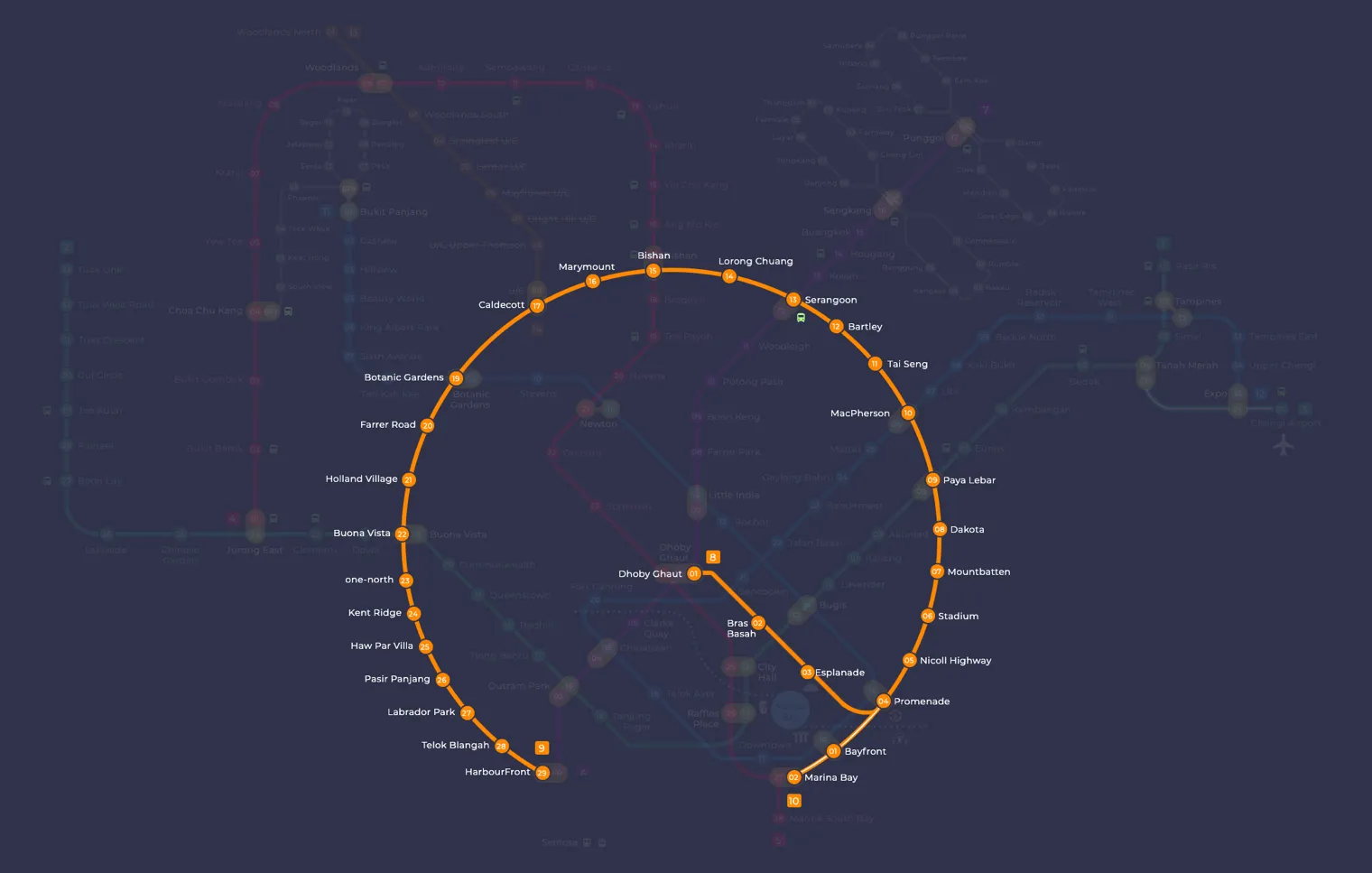
Serangoon on the Circle Line map
Serangoon MRT station at a glance
| Station codes | CC13NE12 |
|---|---|
| Lines | Circle Line North East Line |
| Line colour | Yellow line (Circle Line) Purple line (North East Line) |
| Interchange | Yes, change between 2 lines here |
| Chinese name | 实龙岗 |
| Tamil name | சிராங்கூன் |
| Opened | 20 June 2003 (23 years ago) |
| Operator | SMRT Trains and SBS Transit |
| Station type | Underground |
| Platforms | 4 (2 island platforms) |
| Address | 600 Upper Serangoon Road, Singapore 534801 |
| Daily ridership | About 51,738 passengers a day (2024) |
| Next stations | |
| Train times | Circle Line: first train leaves the terminus at 5:37 AM, last train 11:56 PM North East Line: first train leaves the terminus at 5:39 AM, last train 11:55 PM Full first and last train guide |
Opening date, operator and ridership figures are LTA data as recorded on Wikipedia.
See Serangoon on the map. The interactive map opens with this station highlighted, so you can trace the route from where you are.
The station connects directly with Nex and the Serangoon Bus Interchange, so it acts as the main transport hub for the town centre. Most passengers live in the surrounding residential estates. Others come to shop at Nex, change between the two lines or transfer to buses. The Serangoon Neighbourhood Police Centre and the Braddell Heights Community Hub are also close by.
History of Serangoon MRT station
The North East Line part of the station opened on 20 June 2003. The Circle Line platforms followed on 28 May 2009, when the third stage of that line began service. Engineers built the station at the same time as the road viaduct that now carries traffic above Upper Serangoon Road. In 2005, groundwater seeped into the works for the Circle Line tunnels and caused the existing North East Line station to sink by about one centimetre, so trains had to slow down through the station as a precaution.
Inside Serangoon MRT station
The station has eight entrances, and four of them are triangular openings enclosed in cubic structures. Three works from the Art-in-Transit programme are on display: Memories of Childhood, a series of woodcut prints by Eng Joo Heng, on the North East Line platforms and concourse; View of Life, a painting by Sarkasi Said, in the Circle Line concourse; and Matrix, a set of art seats on the Circle Line platforms.
For residents, Serangoon MRT station is a practical starting point for everyday errands. Food Junction and Food Republic are both within a two minute walk for a quick meal, and Serangoon Public Library is about a minute away. Serangoon Central Village is around seven minutes on foot and offers market shopping and hawker food. Serangoon Stadium is roughly a 12 minute walk for sport and exercise, and Nanyang Junior College is about 11 minutes away.
Around Serangoon MRT station
Serangoon station sits at the heart of a busy residential and commercial hub centred on Serangoon Central. The area is well served by shopping and dining options, with Food Junction and Food Republic both within a short walk. Serangoon Public Library and Serangoon Bus Interchange add to the everyday amenities that make this a practical base for residents and visitors alike.
| Place | Type | Distance | Why go |
|---|---|---|---|
| Food Junction | Food centre | About 50 m (~1 min walk) | Visit Food Junction for a wide variety of hawker-style meals in a food court setting. |
| Serangoon Public Library | Library | About 90 m (~1 min walk) | Visit Serangoon Public Library to borrow books, study or access community programmes. |
| Serangoon Bus Interchange | Bus interchange | About 130 m (~2 min walk) | Use Serangoon Bus Interchange to connect to bus services across the wider region. |
| Food Republic | Food centre | About 140 m (~2 min walk) | Visit Food Republic for another food court option with a range of local and Asian dishes. |
| Serangoon Central Village | Market / hawker centre | About 420 m (~7 min walk) | Visit Serangoon Central Village for a traditional wet market and local hawker food. |
| Nanyang Junior College | College | About 690 m (~11 min walk) | Nanyang Junior College is a pre-university institution for students in the area. |
| Serangoon Stadium | Stadium | About 740 m (~12 min walk) | Serangoon Stadium is a community sports facility used for football and athletics. |
| Upper Serangoon Shopping Centre | Shopping mall | About 810 m (~13 min walk) | Upper Serangoon Shopping Centre offers retail shops serving the surrounding neighbourhood. |
Places and straight-line distances from OpenStreetMap data (© OpenStreetMap contributors). Actual walking routes may be longer.
How to get to Serangoon by MRT
Worked out from the network map. Stop counts are station to station and do not include walking or waiting time.
| From Changi Airport | Take the East West Line from Changi Airport to Paya Lebar (6 stops), then change to the Circle Line from Paya Lebar to Serangoon (4 stops). About 10 stops with 1 change. |
|---|---|
| From Orchard | Take the North South Line from Orchard to Bishan (5 stops), then change to the Circle Line from Bishan to Serangoon (2 stops). About 7 stops with 1 change. |
| From City Hall | Take the North South Line from City Hall to Dhoby Ghaut (1 stop), then change to the North East Line from Dhoby Ghaut to Serangoon (6 stops). About 7 stops with 1 change. |
| From Jurong East | Take the East West Line from Jurong East to Buona Vista (3 stops), then change to the Circle Line from Buona Vista to Serangoon (8 stops). About 11 stops with 1 change. |
| From Woodlands | Take the North South Line from Woodlands to Bishan (8 stops), then change to the Circle Line from Bishan to Serangoon (2 stops). About 10 stops with 1 change. |
| From HarbourFront | Take the North East Line from HarbourFront to Serangoon (10 stops). About 10 stops, no changes. |
Fares from Serangoon MRT station
A trip from Serangoon to Changi Airport (about 18 km) costs S$2.20 on an adult SimplyGo or EZ-Link card. Fares are charged by distance, so the table below shows the estimated adult card fare from Serangoon to the main hubs, the early bird fare for journeys that start before 7.45am on weekdays, and the fare that applies from 26 December 2026.
| To | Distance | Adult card | Before 7.45am | From 26 Dec 2026 |
|---|---|---|---|---|
| Changi Airport | about 18 km, 10 stops | S$2.20 | S$1.70 | S$2.33 |
| Orchard | about 9 km, 7 stops | S$1.86 | S$1.36 | S$1.99 |
| City Hall | about 8 km, 7 stops | S$1.82 | S$1.32 | S$1.95 |
| Raffles Place | about 10 km, 8 stops | S$1.86 | S$1.36 | S$1.99 |
| Jurong East | about 19 km, 11 stops | S$2.27 | S$1.77 | S$2.40 |
| Woodlands | about 20 km, 10 stops | S$2.30 | S$1.80 | S$2.43 |
| HarbourFront | about 13 km, 10 stops | S$1.98 | S$1.48 | S$2.11 |
| Marina Bay | about 11 km, 9 stops | S$1.90 | S$1.40 | S$2.03 |
Estimated from the route distance between stations and the Public Transport Council fare table in force from 27 December 2025. The exact fare can differ by one band. Cash fares are higher. Use the fare calculator for any other journey, or check your fare on the SimplyGo app.
Tips for using Serangoon MRT station
- Food Junction, Serangoon Public Library, Serangoon Bus Interchange and Food Republic are all within a 2-minute walk, making them easy to reach on foot from the station.
- Serangoon is an interchange station serving both the Circle Line and the North East Line, so allow extra time during morning and evening peak hours when platforms and concourses can be crowded.
- Serangoon Central Village, Nanyang Junior College, Serangoon Stadium and Upper Serangoon Shopping Centre are all more than 400 m away, so consider taking a bus from Serangoon Bus Interchange rather than walking, especially in hot or wet weather.
- If you are transferring between the Circle Line and the North East Line, factor in a few extra minutes as the interchange can be busy, particularly on weekends and public holidays.
All stations on the Circle Line
In order along the line, with Serangoon marked. Stations with their own guide are linked.
| Code | Station | Interchange |
|---|---|---|
| CC1 | Dhoby Ghaut | NS / NE / CC |
| CC2 | Bras Basah | None |
| CC3 | Esplanade | None |
| CC4 | Promenade | CC / DT |
| CC5 | Nicoll Highway | None |
| CC6 | Stadium | None |
| CC7 | Mountbatten | None |
| CC8 | Dakota | None |
| CC9 | Paya Lebar | CC / EW |
| CC10 | MacPherson | CC / DT |
| CC11 | Tai Seng | None |
| CC12 | Bartley | None |
| CC13 | Serangoon (you are here) | CC / NE |
| CC14 | Lorong Chuan | None |
| CC15 | Bishan | NS / CC |
| CC16 | Marymount | None |
| CC17 | Caldecott | CC / TE |
| CC19 | Botanic Gardens | DT / CC |
| CC20 | Farrer Road | None |
| CC21 | Holland Village | None |
| CC22 | Buona Vista | EW / CC |
| CC23 | one-north | None |
| CC24 | Kent Ridge | None |
| CC25 | Haw Par Villa | None |
| CC26 | Pasir Panjang | None |
| CC27 | Labrador Park | None |
| CC28 | Telok Blangah | None |
| CC29 | HarbourFront | CC / NE |
| CC30 | Keppel | None |
| CC31 | Cantonment | None |
| CC32 | Prince Edward Road | None |
Read the full Circle Line guide.
All stations on the North East Line
In order along the line, with Serangoon marked. Stations with their own guide are linked.
| Code | Station | Interchange |
|---|---|---|
| NE1 | HarbourFront | CC / NE |
| NE3 | Outram Park | TE / EW / NE |
| NE4 | Chinatown | DT / NE |
| NE5 | Clarke Quay | None |
| NE6 | Dhoby Ghaut | NS / NE / CC |
| NE7 | Little India | DT / NE |
| NE8 | Farrer Park | None |
| NE9 | Boon Keng | None |
| NE10 | Potong Pasir | None |
| NE11 | Woodleigh | None |
| NE12 | Serangoon (you are here) | CC / NE |
| NE13 | Kovan | None |
| NE14 | Hougang | None |
| NE15 | Buangkok | None |
| NE16 | Sengkang | NE / STC |
| NE17 | Punggol | NE / PTC |
| NE18 | Punggol Coast | None |
Read the full North East Line guide.
Serangoon MRT station: common questions
Which line is Serangoon MRT station on?
Serangoon is on the Circle Line and the North East Line. Its station codes are CC13 and NE12.
Is Serangoon an interchange station?
Yes. You can change between the Circle Line and the North East Line inside the station without leaving the paid area.
What time is the first and last train at Serangoon?
Times below are for the first and last train leaving the line terminus; trains reach Serangoon a few minutes later depending on its position on the line. Circle Line first train 5:37 AM, last train 11:56 PM. North East Line first train 5:39 AM, last train 11:55 PM. Check the operator for holiday changes.
What is near Serangoon MRT station?
Several amenities are within easy walking distance, including Food Junction, Serangoon Public Library, Serangoon Bus Interchange and Food Republic, all approximately 50 to 140 m away. Further out, at approximate distances of 420 m to 810 m, you will find Serangoon Central Village, Nanyang Junior College, Serangoon Stadium and Upper Serangoon Shopping Centre.
Which food centre or food court is closest to Serangoon station?
Food Junction is the closest, at approximately 50 m straight-line distance and roughly a 1-minute walk. Food Republic is the next nearest food court, at approximately 140 m away.
How far is Serangoon Stadium from Serangoon MRT station?
Serangoon Stadium is approximately 740 m away in a straight line, which is roughly a 12-minute walk. You may prefer to take a bus from Serangoon Bus Interchange to get there more quickly.
How do I get to Serangoon from Changi Airport by MRT?
Take the East West Line from Changi Airport to Paya Lebar (6 stops), then change to the Circle Line from Paya Lebar to Serangoon (4 stops). About 10 stops with 1 change.
Sources: station codes, line colours and interchanges from the LTA rail system map; operating hours from SMRT and SBS Transit. Last reviewed October 2026.
News and guides mentioning Serangoon
- SBS Transit Disability Support Training: 70% of Staff by 2030 6 Nov 2026
- Future MRT Map Singapore: Every New Line and Extension to 2040 21 Oct 2026
- Commuter Fatigue and the North-South Corridor Delay 6 Oct 2026
- Sengkang West LRT Reopens Oct 4: What Riders Need to Know 5 Oct 2026
Plan the rest of the trip
Every station on the Circle Line and the North East Line is listed on its line guide, with the full route and interchanges. For times, see the first and last train guide, and for the whole network in one view use the interactive Singapore MRT map or the PDF map.
Exits and buses at Serangoon station
Serangoon has 4 mapped exits (A to F). The letters match the signs inside the station; the landmark beside each one is the closest mapped place to that entrance, so pick the exit that comes up nearest to where you are going.
- Exit A: closest to Food Junction (about 117 m from the entrance)
- Exit C: closest to Serangoon Public Library (about 80 m from the entrance)
- Exit D
- Exit F: closest to Serangoon Bus Interchange (about 64 m from the entrance)
Bus stops within 250 m of Serangoon station
| Bus stop | Stop code | Services | From station |
|---|---|---|---|
| Serangoon Station Exit H | 62131 | 45, 58, 58A, 101, 103, 107, 107M, 147, 153, 317, 853, 853M, NR6 | 74 m |
| Serangoon Station Exit E | 66351 | 22, 43, 43M, 53, 70, 70M, 81, 82, 315 | 94 m |
| Serangoon Station Exit A/Blk 413 | 62139 | 45, 45A, 58, 107, 107M, 147, 147A, 153, 158, 853, 853M | 113 m |
| Serangoon Station Exit C/Blk 201 | 66359 | 22, 43, 53, 53M, 70, 70A, 70B, 70M, 116, 116A, 315 | 133 m |
| Opposite Serangoon Station Exit F | 66381 | 45, 58, 133, 135 | 172 m |
| Serangoon Interchange | 66009 | 100, 100A, 101, 103, 105, 109, 109A, 158, 315, 317, 506 | 175 m |
Exits and bus services come from OpenStreetMap and can change when roads or routes are revised; check the board at the stop or the operator app before relying on a service late at night. For the nearest station to where you are now, use the MRT near me finder.
Places to visit from Serangoon station
See every guide on how to get to Singapore's attractions, hospitals and malls by MRT, with routes and fares from Changi Airport, Orchard and the city.
MRT routes from Serangoon
Step-by-step directions with stops, changes, fare and time: Serangoon to Punggol.
Routes to Serangoon: Changi Airport to Serangoon | Orchard to Serangoon.
More on the MRT routes hub.
Hungry? See food near Serangoon MRT: hawker centres, food courts and cafes with walking times.