
Esplanade MRT Station
Esplanade MRT station is a station on the Circle Line, carrying the station code CC3. It sits in the civic and cultural district of central Singapore, serving an area known for its arts venues, open waterfront spaces, and proximity to the city centre rather than any residential neighbourhood or major commercial office zone.
Esplanade on the Circle Line map
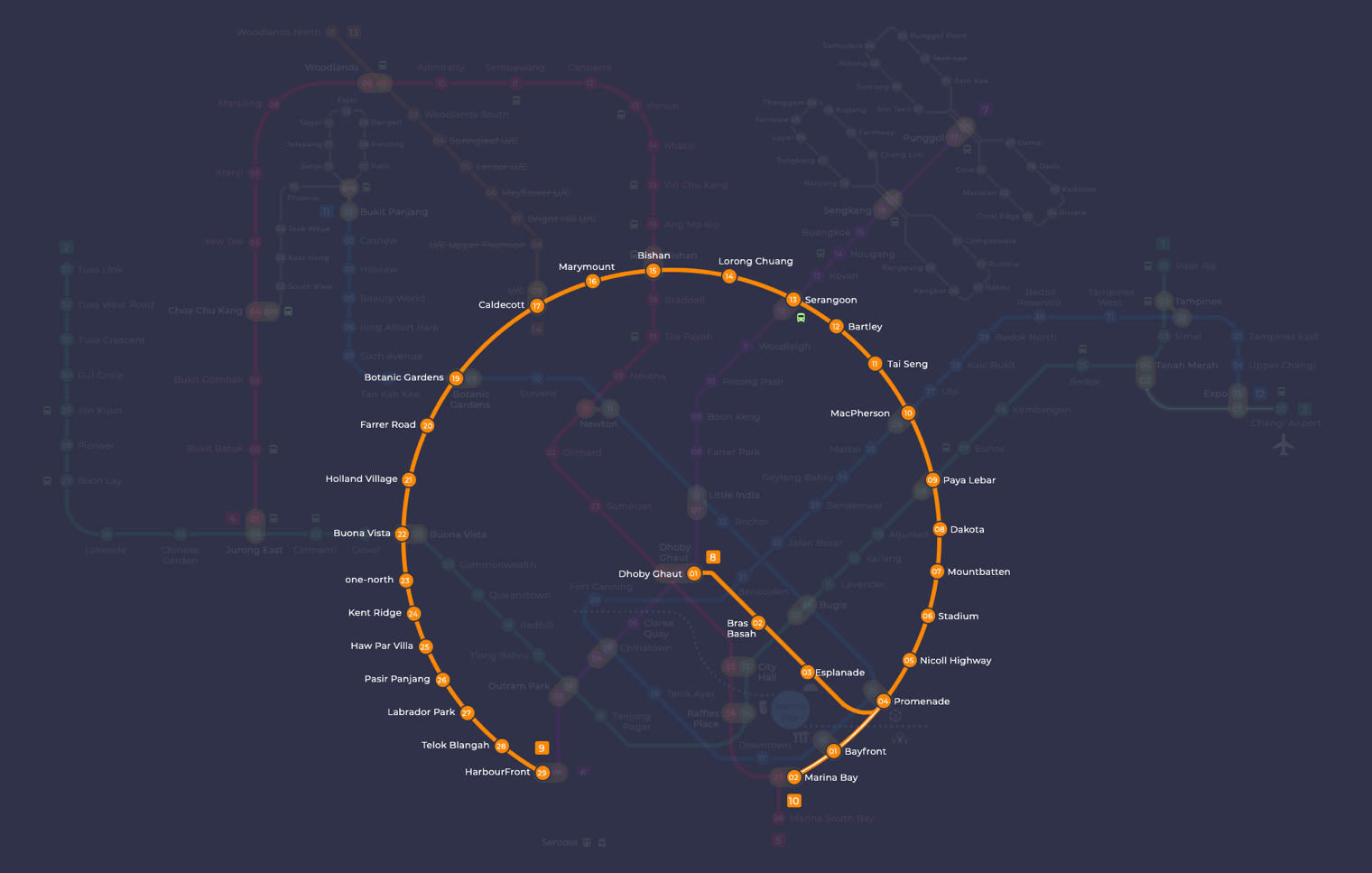
Esplanade MRT station at a glance
| Station codes | CC3 |
|---|---|
| Lines | Circle Line |
| Line colour | Yellow line (Circle Line) |
| Interchange | No, single line station |
| Chinese name | 滨海中心 |
| Tamil name | எஸ்பிளனேட் |
| Next stations | |
| Train times | Circle Line: first train leaves the terminus at 5:37 AM, last train 11:56 PM Full first and last train guide |
See Esplanade on the map. The interactive map opens with this station highlighted, so you can trace the route from where you are.
The station is not an interchange, but its position on the Circle Line gives travellers direct access to a wide range of destinations without changing trains. Neighbouring stations are Bras Basah to the west and Promenade to the east, where passengers can transfer to the Downtown Line, making onward journeys to the Marina Bay area and beyond straightforward.
The Esplanade, Singapore's main performing arts centre with its distinctive durian-shaped roof, is within easy walking distance of this station. The nearby Esplanade Park and the waterfront promenade along Marina Bay are also reachable on foot, making this station a practical starting point for those visiting the civic district or taking a walk along the bay.
Around Esplanade MRT station
Esplanade station sits in the heart of Singapore's civic and entertainment district, surrounded by shopping malls, museums, and leisure attractions. CityLink Mall and Marina Square are among the retail destinations within easy reach, while the National Gallery Singapore and Peranakan Museum serve the area's strong cultural character. The neighbourhood draws a mix of tourists, office workers, and locals throughout the day.
| Place | Type | Distance | Why go |
|---|---|---|---|
| CityLink Mall | Shopping mall | About 180 m (~3 min walk) | CityLink Mall: a convenient stop for shopping and dining in the city centre area. |
| Raffles City Shopping Centre | Shopping mall | About 250 m (~4 min walk) | Raffles City Shopping Centre: a large mall with a wide range of retail and dining options. |
| Long Bar | Attraction | About 300 m (~5 min walk) | Long Bar: known as the birthplace of the Singapore Sling cocktail, worth a visit for history lovers. |
| Marina Square | Shopping mall | About 330 m (~5 min walk) | Marina Square: a spacious mall offering retail, dining, and leisure options by the bay. |
| Mint Museum of Toys | Museum | About 340 m (~6 min walk) | Mint Museum of Toys: a museum dedicated to vintage toys and collectibles from around the world. |
| Pororo Park | Theme park | About 360 m (~6 min walk) | Pororo Park: an indoor theme park suitable for young children and families. |
| National Gallery Singapore | Museum | About 570 m (~9 min walk) | National Gallery Singapore: showcases a significant collection of Southeast Asian and Singaporean art. |
| Peranakan Museum | Museum | About 720 m (~12 min walk) | Peranakan Museum: explores the culture and heritage of the Peranakan communities of Southeast Asia. |
Places and straight-line distances from OpenStreetMap data (© OpenStreetMap contributors). Actual walking routes may be longer.
How to get to Esplanade by MRT
Worked out from the network map. Stop counts are station to station and do not include walking or waiting time.
| From Changi Airport | Take the East West Line from Changi Airport to Paya Lebar (6 stops), then change to the Circle Line from Paya Lebar to Esplanade (6 stops). About 12 stops with 1 change. |
|---|---|
| From Orchard | Take the North South Line from Orchard to Dhoby Ghaut (2 stops), then change to the Circle Line from Dhoby Ghaut to Esplanade (2 stops). About 4 stops with 1 change. |
| From City Hall | Take the North South Line from City Hall to Dhoby Ghaut (1 stop), then change to the Circle Line from Dhoby Ghaut to Esplanade (2 stops). About 3 stops with 1 change. |
| From Jurong East | Take the East West Line from Jurong East to Outram Park (8 stops), then change to the North East Line from Outram Park to Dhoby Ghaut (3 stops), then change to the Circle Line from Dhoby Ghaut to Esplanade (2 stops). About 13 stops with 2 changes. |
| From Woodlands | Take the Thomson East Coast Line from Woodlands to Stevens (8 stops), then change to the Downtown Line from Stevens to Promenade (5 stops), then change to the Circle Line from Promenade to Esplanade (1 stop). About 14 stops with 2 changes. |
| From HarbourFront | Take the North East Line from HarbourFront to Dhoby Ghaut (4 stops), then change to the Circle Line from Dhoby Ghaut to Esplanade (2 stops). About 6 stops with 1 change. |
Fares from Esplanade MRT station
A trip from Esplanade to Changi Airport (about 19 km) costs S$2.24 on an adult SimplyGo or EZ-Link card. Fares are charged by distance, so the table below shows the estimated adult card fare from Esplanade to the main hubs, the early bird fare for journeys that start before 7.45am on weekdays, and the fare that applies from 26 December 2026.
| To | Distance | Adult card | Before 7.45am | From 26 Dec 2026 |
|---|---|---|---|---|
| Changi Airport | about 19 km, 12 stops | S$2.24 | S$1.74 | S$2.37 |
| Orchard | about 3 km, 4 stops | S$1.38 | S$0.88 | S$1.51 |
| City Hall | about 3 km, 3 stops | S$1.28 | S$0.78 | S$1.40 |
| Raffles Place | about 4 km, 4 stops | S$1.38 | S$0.88 | S$1.51 |
| Jurong East | about 18 km, 13 stops | S$2.20 | S$1.70 | S$2.33 |
| Woodlands | about 24 km, 14 stops | S$2.38 | S$1.88 | S$2.51 |
| HarbourFront | about 7 km, 6 stops | S$1.68 | S$1.18 | S$1.81 |
| Marina Bay | about 3 km, 3 stops | S$1.28 | S$0.78 | S$1.40 |
Estimated from the route distance between stations and the Public Transport Council fare table in force from 27 December 2025. The exact fare can differ by one band. Cash fares are higher. Use the fare calculator for any other journey, or check your fare on the SimplyGo app.
Tips for using Esplanade MRT station
- CityLink Mall and Raffles City Shopping Centre are the closest destinations and are comfortably reachable on foot within a few minutes.
- Marina Square, Mint Museum of Toys, and Pororo Park are all within roughly five to six minutes on foot and can easily be grouped into one outing.
- The National Gallery Singapore and Peranakan Museum are the furthest destinations at approximately nine to twelve minutes on foot, so allow extra time if you plan to visit them.
- This station is on the Circle Line only, so if you are travelling from a station on another line, plan your interchange in advance to avoid unnecessary doubling back.
All stations on the Circle Line
In order along the line, with Esplanade marked. Stations with their own guide are linked.
| Code | Station | Interchange |
|---|---|---|
| CC1 | Dhoby Ghaut | NS / NE / CC |
| CC2 | Bras Basah | None |
| CC3 | Esplanade (you are here) | None |
| CC4 | Promenade | CC / DT |
| CC5 | Nicoll Highway | None |
| CC6 | Stadium | None |
| CC7 | Mountbatten | None |
| CC8 | Dakota | None |
| CC9 | Paya Lebar | CC / EW |
| CC10 | MacPherson | CC / DT |
| CC11 | Tai Seng | None |
| CC12 | Bartley | None |
| CC13 | Serangoon | CC / NE |
| CC14 | Lorong Chuan | None |
| CC15 | Bishan | NS / CC |
| CC16 | Marymount | None |
| CC17 | Caldecott | CC / TE |
| CC19 | Botanic Gardens | DT / CC |
| CC20 | Farrer Road | None |
| CC21 | Holland Village | None |
| CC22 | Buona Vista | EW / CC |
| CC23 | one-north | None |
| CC24 | Kent Ridge | None |
| CC25 | Haw Par Villa | None |
| CC26 | Pasir Panjang | None |
| CC27 | Labrador Park | None |
| CC28 | Telok Blangah | None |
| CC29 | HarbourFront | CC / NE |
| CC30 | Keppel | None |
| CC31 | Cantonment | None |
| CC32 | Prince Edward Road | None |
Read the full Circle Line guide.
Esplanade MRT station: common questions
Which line is Esplanade MRT station on?
Esplanade is on the Circle Line. Its station code is CC3.
Is Esplanade an interchange station?
No. Esplanade is served by the Circle Line only. The nearest interchange is shown in the next stations row above.
What time is the first and last train at Esplanade?
Times below are for the first and last train leaving the line terminus; trains reach Esplanade a few minutes later depending on its position on the line. Circle Line first train 5:37 AM, last train 11:56 PM. Check the operator for holiday changes.
What is near Esplanade MRT station?
Esplanade station is surrounded by a variety of attractions and malls, including CityLink Mall, Raffles City Shopping Centre, Marina Square, Long Bar, Mint Museum of Toys, Pororo Park, National Gallery Singapore, and the Peranakan Museum, all within approximately twelve minutes on foot.
Which mall is closest to Esplanade MRT station?
CityLink Mall is the closest mall at approximately 180 metres, roughly a three-minute walk, followed by Raffles City Shopping Centre at approximately 250 metres.
How far is the National Gallery Singapore from Esplanade MRT station?
The National Gallery Singapore is approximately 570 metres from Esplanade station, which is roughly a nine-minute walk.
How do I get to Esplanade from Changi Airport by MRT?
Take the East West Line from Changi Airport to Paya Lebar (6 stops), then change to the Circle Line from Paya Lebar to Esplanade (6 stops). About 12 stops with 1 change.
Sources: station codes, line colours and interchanges from the LTA rail system map; operating hours from SMRT and SBS Transit. Last reviewed September 2026.
News and guides mentioning Esplanade
- Singapore MRT Network: Lines, Fares & How It All Works 29 Sep 2026
- Most Instagram-Worthy MRT Stations in Singapore 28 Sep 2026
- Singapore Grand Prix 2026: Road Closures, MRT & Bus Hours 9 Sep 2026
- Singapore DJ Plays MRT Jingles at Tomorrowland Belgium 14 Aug 2026
Plan the rest of the trip
Every station on the Circle Line is listed on its line guide, with the full route and interchanges. For times, see the first and last train guide, and for the whole network in one view use the interactive Singapore MRT map or the PDF map.