
Last updated . Facts checked against LTA announcements.
Singapore MRT Map PDF 2026 Download
Updated for 2026: the PDF is the official Land Transport Authority system map, version dated 21 July 2026. It includes the completed Circle Line loop (Keppel, Cantonment and Prince Edward Road), Hume on the Downtown Line, Punggol Coast on the North East Line, and the Thomson-East Coast Line through to Bayshore. Map: Land Transport Authority, Singapore.
Download the Singapore MRT map PDF (free)
Official LTA system map, July 2026 edition. Vector PDF, 1.2 MB, one page about 198 cm square, so it stays sharp at any zoom and prints well on A4, A3 or larger paper.
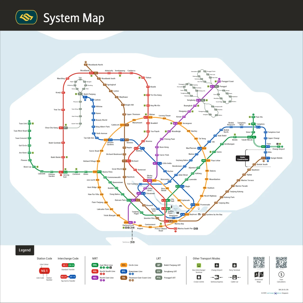

Getting around Singapore? Find any station on the interactive MRT map, or save the PDF map to use offline.
Singapore MRT Map PDF: Download and Use
This page gives you the 2026 Singapore MRT map as a downloadable PDF, straight from the Land Transport Authority. Having it on your phone or printed out means you can check your route any time, with or without an internet connection.
The Singapore MRT map PDF is free to download and free to print as many times as you like. It reflects the network as it stands in 2026, so you can trust the station names, line colours and interchange points are current.
Key takeaways:
-
Offline access: Download the PDF and you can check the map underground or anywhere without a signal.
-
Fully updated: Includes all 2026 additions, including the completed Circle Line loop (Keppel, Cantonment and Prince Edward Road), Hume on the Downtown Line, Punggol Coast on the North East Line, and the Thomson-East Coast Line to Bayshore.
-
High resolution: Station names and interchange markers stay sharp when you zoom in or print.
-
Print-ready: A4 or pocket-sized, the map prints clearly and is easy to carry.
-
Plan your day: Use the map to find the nearest MRT station to wherever you are going, then plan your route before you leave.
Why Download a Singapore MRT Map as a PDF?
Singapore’s rail network covers six colour-coded lines and well over 130 stations, so having a reliable map on hand makes a real difference. A Singapore MRT Map PDF is easy to save, easy to zoom into, and works without an internet connection. That alone puts it ahead of a static image you can barely read on a small screen.
1. Accuracy: The 2026 Network Updates
The network has changed significantly in recent years and the 2026 map reflects those changes. The Circle Line is now a complete loop after Stage 6 opened on 12 July 2026, adding Keppel, Cantonment and Prince Edward Road. The Thomson-East Coast Line has also extended further along the east coast, so an older map will leave you guessing.
2. Offline Access
The biggest practical advantage of a PDF is offline accessibility. Save it to your phone, tablet or laptop and you can open it anywhere: underground between interchanges, out in the suburbs, or wherever your data signal drops out. No roaming charges, no buffering.
3. Clarity When You Zoom In
JPEG maps turn blurry the moment you zoom in. A Singapore MRT Map PDF built with vector graphics stays sharp at any magnification, so you can read small station names and busy interchange labels without squinting. This matters most at complex interchanges like Dhoby Ghaut or Jurong East, where finding the right platform quickly counts.
| Feature | Singapore MRT Map PDF (2026) | Standard Image/App |
| Network Relevance | Fully updated with 2026 TEL & CCL expansions | Often outdated |
| Convenience | Downloadable across all Apple & Android devices | App installation required |
| Flexibility | 100% accessible offline without Wi-Fi | Often requires data/internet |
| Visual Quality | High-resolution, vector-based legibility | Can become pixelated when zoomed |
The Practical Benefits of the MRT Map PDF
The PDF format is genuinely useful for getting around Singapore, online or not.
Print it out: Print a copy before you travel, which is handy if your phone battery dies or you prefer paper. It is also useful for anyone who wants a quick reference without unlocking a screen.
Works on any device: Save the file to Apple Books, Google Drive, or your phone’s default files app. No special software needed, so you can pull it up quickly wherever you are.
Clear English labels: Every station is named in English and each line has a distinct colour, so reading the map is straightforward. If you are arriving at Changi Airport and heading to Orchard, for example, you can plan your route at a glance.
Whether you print a copy or save the 2026 Singapore MRT Map PDF to your phone, having it to hand makes getting around the network much easier. Download it before your next trip.
Exploring the Singapore MRT Map PDF 2026
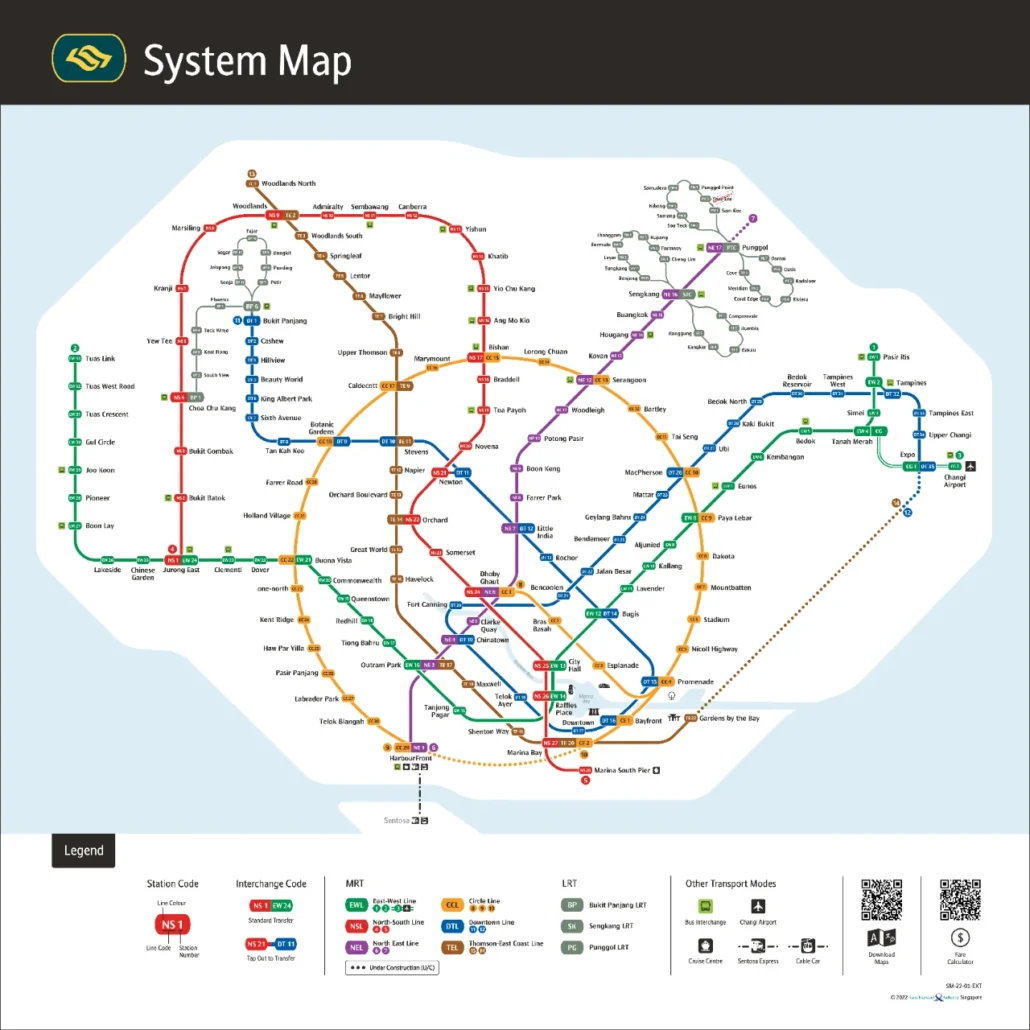
What’s New in the 2026 Singapore MRT Map PDF?
The 2026 Singapore MRT Map PDF reflects the latest rail developments from the Land Transport Authority (LTA). Several new stations and line extensions have opened over the past couple of years, so it is worth making sure you have the most current version before you travel.
Spotlight: The Thomson-East Coast Line (TEL)
The Thomson-East Coast Line (TEL), shown in brown on the map, is one of the most significant additions to the network in recent years. It runs from the north of Singapore through the city centre and out towards the east coast, connecting residential areas directly to the Central Business District and Marina Bay. Stage 4 opened on 23 June 2024, adding seven stations from Tanjong Rhu (TE23) to Bayshore (TE29). Stage 5, adding Bedok South and Sungei Bedok, is due in the second half of 2026 but has not opened yet.
Interchanges and Transfer Points
The 2026 map shows how the older North South and East West lines connect with newer additions, including the Circle Line, which now runs as a complete loop following the opening of Stage 6 in July 2026. Spotting your best transfer point is much easier with an up-to-date map.
-
Shorter travel times: You can quickly see which interchange gets you to your destination with the fewest stops or the least backtracking.
-
Easier transfers: Multi-line interchange stations are large, so knowing the layout before you arrive saves time on the ground.
-
Combined MRT and LRT journeys: The map shows where MRT lines connect to the Bukit Panjang, Sengkang and Punggol LRT networks, useful if your destination is off the main rail corridor.
A current PDF map helps you make sense of the network’s scale and pick the right route, whether you tap in with SimplyGo every morning or are visiting Singapore for the first time.
The sections below walk through how to use the map to plan journeys, identify interchange options and find the right station entry points for where you are headed.
Singapore’s MRT Network: A Quick Overview
The Mass Rapid Transit (MRT) is the backbone of getting around Singapore. It is operated by two companies: SMRT runs the North South, East West, Circle and Thomson-East Coast lines as well as Bukit Panjang LRT, while SBS Transit runs the North East and Downtown lines plus the Sengkang and Punggol LRT networks.
A good map makes planning any trip much faster. Download the Singapore MRT route map and you can see all six lines at once, spot your nearest station, pick the right colour-coded line and work out where to change trains to save time.
Here is a quick summary of the major interchange stations where multiple lines meet:
| Interchange Station | Connecting Lines | Key Destinations |
| Dhoby Ghaut (NS24/NE6/CC1) | Red, Purple, Yellow | Orchard Road Shopping Belt |
| Outram Park (EW16/NE3/TE17) | Green, Purple, Brown | Chinatown, Singapore General Hospital |
| Marina Bay (NS27/CE2/TE20) | Red, Yellow, Brown | Financial District, Marina Bay Waterfront |
| Paya Lebar (EW8/CC9) | Green, Yellow | East Coast, Geylang Serai |
| Jurong East (NS1/EW24) | Red, Green | Western Commercial Hub, Science Center |
Whether you are heading into the Central Business District (CBD) on your daily commute or making your way from Changi Airport to the city by MRT, knowing which interchanges to use is the quickest way to get where you are going.
High-Resolution Singapore MRT Map PDF
A blurry map is no use when you are trying to read station codes on a small screen. Downloading a high-resolution vector PDF keeps every label sharp no matter how far you zoom in, whether you are on your phone, tablet or laptop.
Because the file is vector-based, it scales without any loss of quality. Every station code and line colour stays crisp at full size or zoomed right in on a single interchange.
Why download the high-res PDF?
-
Offline access: Save the file to your phone or tablet and you can open it underground or anywhere with no signal, no mobile data needed.
-
Print-ready: The PDF prints cleanly at any size. A printed copy is handy to keep in your bag for a full day out.
-
Easy to read: Clear English labels, consistent colour coding and standard transit symbols mean you can read the map quickly without any guesswork.
Reaching Top Attractions by MRT
The MRT gets you close to most of Singapore’s popular sights without much fuss. Use the map to plan your day by grouping destinations along the same line, so you spend less time travelling and more time actually there.
A few useful starting points:
Where does the MRT take you?
-
Marina Bay Sands and Gardens by the Bay: Alight at Bayfront Station (CE1/DT16) for direct underground access to the Supertree Grove and the Cloud Forest.
-
Sentosa Island and Universal Studios: Take the North East Line or Circle Line to HarbourFront Station (NE1/CC29), then transfer to the Sentosa Express monorail.
-
Heritage districts: The Downtown Line stops at Little India (DT11), while the North East Line brings you to Chinatown (NE4) for street food and historic temples.
Grouping destinations by line keeps your day efficient and cuts down on taxi fares.
4 Tips for Planning Your 2026 Journey
A bit of preparation before you leave makes a real difference on Singapore’s MRT. Here are four practical things worth doing:
1. Use an online route planner. Put your starting point and destination into an MRT route planner before you head out. It will show the fastest route, the right interchange stations, and a realistic travel time.
2. Check the latest 2026 map. The network has changed recently, with Circle Line Stage 6 completing the full loop in July 2026 and Thomson-East Coast Line Stage 4 adding stops along the east coast. Always use the SG MRT Map 2026 edition so you are not following an outdated route.
3. Tap in with SimplyGo. You do not need a paper ticket. Tap your contactless Visa or Mastercard, Apple Pay, Google Pay, or an EZ-Link/SimplyGo card at the fare gates. Your fare is calculated automatically by distance. Visitors can also pick up a Singapore Tourist Pass for unlimited travel over a set number of days.
4. Avoid the peak-hour crowds. If your schedule allows, travel outside the morning rush (roughly 7:30 to 9:00) and the evening commute (roughly 17:00 to 19:30). Trains are noticeably quieter outside these windows, and you will almost always get a seat.
Wrapping Up
The Singapore MRT Map PDF is a straightforward, reliable reference for getting around the island. Keep a copy on your phone and you have the full network to hand whenever you need it.
The map is fully updated for 2026, covering the completed Circle Line loop, the latest TEL stations, and every other current line. Being able to zoom in offline or print a copy for reference means you are not dependent on a data connection when you need to check a route quickly.
Download the Singapore MRT Map PDF, save it to your device, and you are ready to go.
Singapore MRT Map HD and High Resolution Options
Searching for an MRT map in HD usually means one of three things, and this page covers all of them:
- High resolution PDF: the vector file above. Because it is a vector, there is no pixel limit. Zoom in on a single interchange and the station codes stay crisp.
- HD image: the 1280 by 1280 pixel preview is quick to load on a phone and fine for a quick look. Use the PDF when you need to read small station names.
- Interactive map: the zoomable Singapore MRT map on our homepage lets you search any station and highlights it on the network.
For a printed copy, choose “fit to page” in your print settings. On A4 the line names remain readable; on A3 the station codes are easy to read at arm’s length.
Frequently asked questions
Is the Singapore MRT map PDF free to download?
Yes. The PDF is free to download and print, with no sign-up. Save it to your phone, tablet or laptop and you can check it offline, which helps on underground stretches with a weak signal.
Which MRT lines are not shown on the 2026 map because they are not open yet?
The Jurong Region Line and Cross Island Line are not open yet, so they are not shown as running lines. The Downtown Line 3 Extension to Xilin and Sungei Bedok and Thomson-East Coast Line Stage 5 to Bedok South and Sungei Bedok are due in the second half of 2026.
How many stations does the Singapore MRT network have in 2026?
Counting each line separately, the North South Line has 27 stations, the East West Line 35 (including the Changi Airport branch), the North East Line 17, the Circle Line 33, the Downtown Line 35 and the Thomson-East Coast Line 27. Many stations are interchanges, so the total number of separate stations is lower than the sum of those figures.
How do I pay for MRT fares in Singapore?
You can pay using an EZ-Link or SimplyGo card, a contactless bank card, or a mobile wallet. If you are visiting Singapore, the Singapore Tourist Pass is another option worth considering. Just tap in and tap out at the fare gates at each station.
Who operates the different MRT lines in Singapore?
Two companies run the network. SMRT operates the North South, East West, Circle and Thomson-East Coast lines, plus Bukit Panjang LRT. SBS Transit operates the North East and Downtown lines, along with the Sengkang and Punggol LRT networks.