
Pasir Panjang MRT Station
Pasir Panjang MRT station is an underground stop on the Circle Line, where it carries the code CC26. It lies beneath Pasir Panjang Road and the Labrador Viaduct, the section of the West Coast Highway that passes overhead, in the Pasir Panjang area at the southern end of the Queenstown planning area. Since the platforms are below ground, passengers reach them from street level by heading downstairs.
Pasir Panjang on the Circle Line map
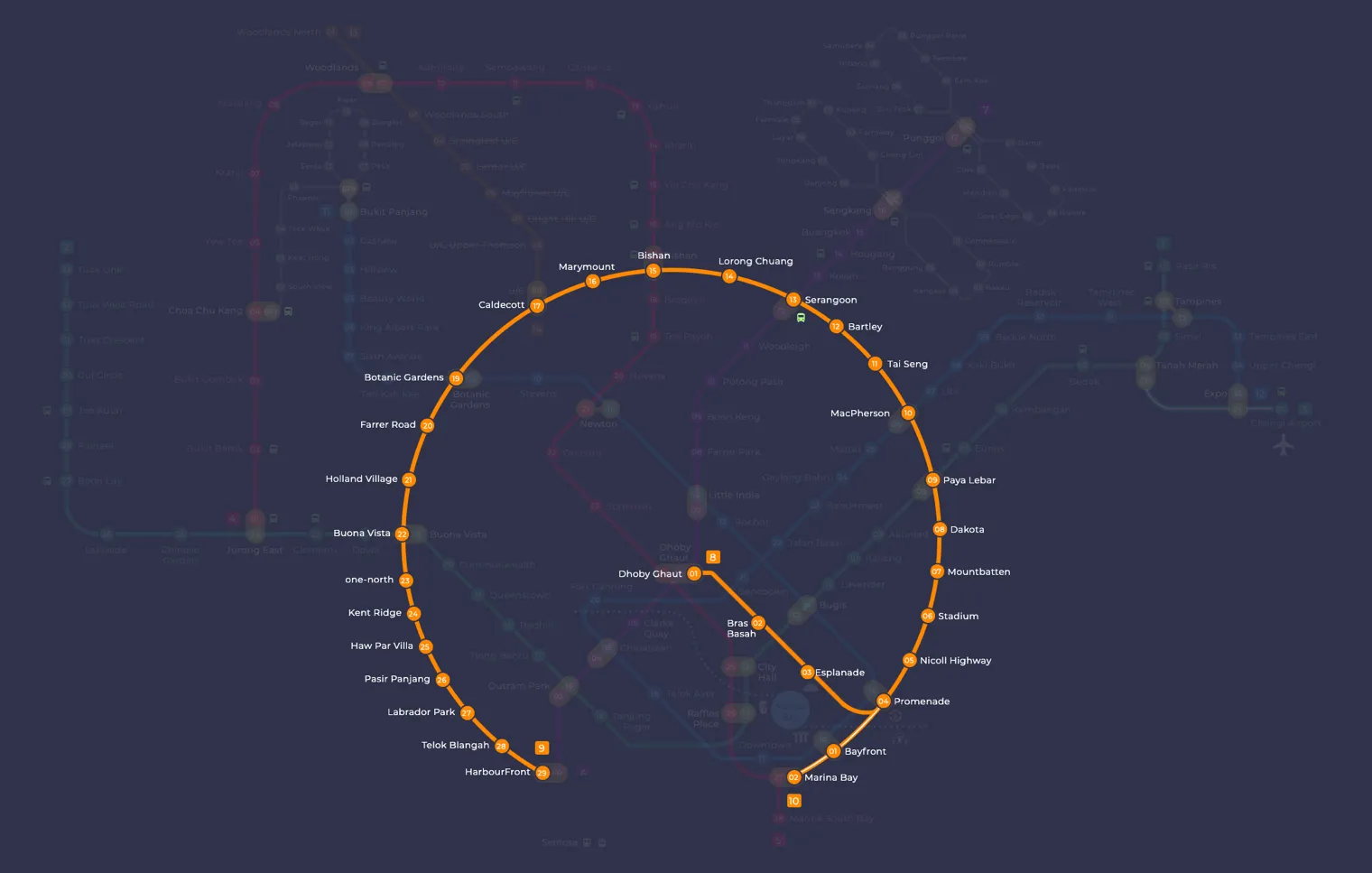
Pasir Panjang MRT station at a glance
| Station codes | CC26 |
|---|---|
| Lines | Circle Line |
| Line colour | Yellow line (Circle Line) |
| Interchange | No, single line station |
| Chinese name | 巴西班让 |
| Tamil name | பாசிர் பாஞ்சாங் |
| Opened | 8 October 2011 (15 years ago) |
| Operator | SMRT Trains |
| Station type | Underground |
| Platforms | 2 (1 island platform) |
| Address | 119 Pasir Panjang Road, Singapore 117424 |
| Daily ridership | About 4,635 passengers a day (2024) |
| Next stations | |
| Train times | Circle Line: first train leaves the terminus at 5:37 AM, last train 11:56 PM Full first and last train guide |
Opening date, operator and ridership figures are LTA data as recorded on Wikipedia.
See Pasir Panjang on the map. The interactive map opens with this station highlighted, so you can trace the route from where you are.
The station’s immediate neighbours are Pasir Panjang Food Centre, Currency House and the Pasir Panjang container terminal. That location makes it a practical stop for people working at these nearby sites, for residents of the surrounding streets, and for visitors who come to eat at the food centre or to learn about the wartime history of the area. It also sits close to Reflections at Bukit Chandu, a museum near the site of the Battle of Pasir Panjang, which draws people with an interest in Singapore’s Second World War past.
History of Pasir Panjang MRT station
The station welcomed its first passengers on 8 October 2011, a date that had been made public in August of the same year. It opened as part of the Circle Line, linking this southern stretch of Pasir Panjang Road to the rest of the rail network. The surrounding area has a much longer story, as the Battle of Pasir Panjang was fought nearby during the Second World War.
Inside Pasir Panjang MRT station
The public artwork here is Lieutenant Adnan by Ho Tzu Nyen, commissioned under the Art in Transit programme. It takes the form of mock posters for an invented film about Lieutenant Adnan bin Saidi, a war hero who fought in the Battle of Pasir Panjang, with Singapore actor Aaron Aziz cast in the lead role; you will find the posters on the lift shaft and at points around the station.
Most people who use Pasir Panjang MRT station are heading for food, green space or local history. Pasir Panjang Food Centre is about 30 m away, roughly a one minute walk, and two more food options, Rice Bowl and Eng Lock Koo Coffeeshop, are within about four minutes on foot. For a short outdoor break, Jambol Place Park and Pasir Panjang Park are both under ten minutes away.
Reflections at Bukit Chandu is around an eight minute walk, which makes the station a sensible starting point for a visit to the museum, and Kent Ridge Park, at about 13 minutes on foot, is close enough for a longer walk on the same trip. Masjid Ahmad, a place of worship around 11 minutes away, is also within easy reach for residents and visitors in the area.
Around Pasir Panjang MRT station
Pasir Panjang station sits in a mixed neighbourhood of residential blocks, light industrial premises and green spaces along the southern edge of Singapore. The area is known for its proximity to nature, with Pasir Panjang Park and Kent Ridge Park both within walking distance. Everyday dining needs are well served, with Pasir Panjang Food Centre just moments from the station exit.
| Place | Type | Distance | Why go |
|---|---|---|---|
| Pasir Panjang Food Centre | Food centre | About 30 m (~1 min walk) | Visit for a wide variety of local hawker food and drinks. |
| Rice Bowl | Food centre | About 170 m (~3 min walk) | A neighbourhood food centre offering casual cooked food options. |
| Eng Lock Koo Coffeeshop | Food centre | About 230 m (~4 min walk) | A traditional coffeeshop serving local food and beverages. |
| Jambol Place Park | Park | About 340 m (~6 min walk) | A small neighbourhood park suitable for a quiet outdoor stroll. |
| Pasir Panjang Park | Park | About 400 m (~7 min walk) | A waterfront park along the southern coastline for leisure walks. |
| Reflections at Bukit Chandu | Museum | About 470 m (~8 min walk) | A museum commemorating the Battle of Pasir Panjang and wartime history. |
| Masjid Ahmad | Place of worship | About 690 m (~11 min walk) | A local mosque serving the Muslim community in the area. |
| Kent Ridge Park | Park | About 810 m (~13 min walk) | A larger hilltop park with forested trails and open green spaces. |
Places and straight-line distances from OpenStreetMap data (© OpenStreetMap contributors). Actual walking routes may be longer.
How to get to Pasir Panjang by MRT
Worked out from the network map. Stop counts are station to station and do not include walking or waiting time.
| From Changi Airport | Take the East West Line from Changi Airport to Outram Park (14 stops), then change to the North East Line from Outram Park to HarbourFront (1 stop), then change to the Circle Line from HarbourFront to Pasir Panjang (3 stops). About 18 stops with 2 changes. |
|---|---|
| From Orchard | Take the Thomson East Coast Line from Orchard to Outram Park (3 stops), then change to the North East Line from Outram Park to HarbourFront (1 stop), then change to the Circle Line from HarbourFront to Pasir Panjang (3 stops). About 7 stops with 2 changes. |
| From City Hall | Take the North South Line from City Hall to Marina Bay (2 stops), then change to the Circle Line from Marina Bay to Pasir Panjang (7 stops). About 9 stops with 1 change. |
| From Jurong East | Take the East West Line from Jurong East to Buona Vista (3 stops), then change to the Circle Line from Buona Vista to Pasir Panjang (4 stops). About 7 stops with 1 change. |
| From Woodlands | Take the Thomson East Coast Line from Woodlands to Caldecott (7 stops), then change to the Circle Line from Caldecott to Pasir Panjang (8 stops). About 15 stops with 1 change. |
| From HarbourFront | Take the Circle Line from HarbourFront to Pasir Panjang (3 stops). About 3 stops, no changes. |
Fares from Pasir Panjang MRT station
A trip from Pasir Panjang to Changi Airport (about 35 km) costs S$2.51 on an adult SimplyGo or EZ-Link card. Fares are charged by distance, so the table below shows the estimated adult card fare from Pasir Panjang to the main hubs, the early bird fare for journeys that start before 7.45am on weekdays, and the fare that applies from 26 December 2026.
| To | Distance | Adult card | Before 7.45am | From 26 Dec 2026 |
|---|---|---|---|---|
| Changi Airport | about 35 km, 22 stops | S$2.51 | S$2.01 | S$2.64 |
| Orchard | about 10 km, 7 stops | S$1.86 | S$1.36 | S$1.99 |
| City Hall | about 11 km, 9 stops | S$1.90 | S$1.40 | S$2.03 |
| Raffles Place | about 9 km, 8 stops | S$1.86 | S$1.36 | S$1.99 |
| Jurong East | about 11 km, 7 stops | S$1.94 | S$1.44 | S$2.07 |
| Woodlands | about 26 km, 15 stops | S$2.43 | S$1.93 | S$2.56 |
| HarbourFront | about 4 km, 3 stops | S$1.38 | S$0.88 | S$1.51 |
| Marina Bay | about 8 km, 7 stops | S$1.82 | S$1.32 | S$1.95 |
Estimated from the route distance between stations and the Public Transport Council fare table in force from 27 December 2025. The exact fare can differ by one band. Cash fares are higher. Use the fare calculator for any other journey, or check your fare on the SimplyGo app.
Tips for using Pasir Panjang MRT station
- Pasir Panjang Food Centre is the closest dining option, roughly a one-minute walk from the station, making it the most convenient choice for a quick meal.
- Kent Ridge Park and Reflections at Bukit Chandu are over 400 metres away, so allow at least 10 to 15 minutes on foot or consider taking a local bus to reduce walking time.
- For visits to Kent Ridge Park, plan for a longer outing as the terrain is hilly and the walk from the station is approximately 13 minutes at a comfortable pace.
- The Circle Line runs frequently, but during peak hours trains can be busy; plan your journey with a small buffer if you are heading to multiple destinations in the area.
All stations on the Circle Line
In order along the line, with Pasir Panjang marked. Stations with their own guide are linked.
| Code | Station | Interchange |
|---|---|---|
| CC1 | Dhoby Ghaut | NS / NE / CC |
| CC2 | Bras Basah | None |
| CC3 | Esplanade | None |
| CC4 | Promenade | CC / DT |
| CC5 | Nicoll Highway | None |
| CC6 | Stadium | None |
| CC7 | Mountbatten | None |
| CC8 | Dakota | None |
| CC9 | Paya Lebar | CC / EW |
| CC10 | MacPherson | CC / DT |
| CC11 | Tai Seng | None |
| CC12 | Bartley | None |
| CC13 | Serangoon | CC / NE |
| CC14 | Lorong Chuan | None |
| CC15 | Bishan | NS / CC |
| CC16 | Marymount | None |
| CC17 | Caldecott | CC / TE |
| CC19 | Botanic Gardens | DT / CC |
| CC20 | Farrer Road | None |
| CC21 | Holland Village | None |
| CC22 | Buona Vista | EW / CC |
| CC23 | one-north | None |
| CC24 | Kent Ridge | None |
| CC25 | Haw Par Villa | None |
| CC26 | Pasir Panjang (you are here) | None |
| CC27 | Labrador Park | None |
| CC28 | Telok Blangah | None |
| CC29 | HarbourFront | CC / NE |
| CC30 | Keppel | None |
| CC31 | Cantonment | None |
| CC32 | Prince Edward Road | None |
Read the full Circle Line guide.
Pasir Panjang MRT station: common questions
Which line is Pasir Panjang MRT station on?
Pasir Panjang is on the Circle Line. Its station code is CC26.
Is Pasir Panjang an interchange station?
No. Pasir Panjang is served by the Circle Line only. The nearest interchange is shown in the next stations row above.
What time is the first and last train at Pasir Panjang?
Times below are for the first and last train leaving the line terminus; trains reach Pasir Panjang a few minutes later depending on its position on the line. Circle Line first train 5:37 AM, last train 11:56 PM. Check the operator for holiday changes.
What is near Pasir Panjang MRT station?
The station is close to several dining options including Pasir Panjang Food Centre at approximately 30 metres, as well as green spaces such as Pasir Panjang Park and Kent Ridge Park. Reflections at Bukit Chandu, a museum about wartime history, is also within walking distance at approximately 470 metres.
Which food centre is closest to Pasir Panjang station?
Pasir Panjang Food Centre is the closest, at approximately 30 metres from the station, making it roughly a one-minute walk.
How far is Kent Ridge Park from Pasir Panjang MRT station?
Kent Ridge Park is approximately 810 metres away in a straight line, which is roughly a 13-minute walk from the station.
How do I get to Pasir Panjang from Changi Airport by MRT?
Take the East West Line from Changi Airport to Outram Park (14 stops), then change to the North East Line from Outram Park to HarbourFront (1 stop), then change to the Circle Line from HarbourFront to Pasir Panjang (3 stops). About 18 stops with 2 changes.
Sources: station codes, line colours and interchanges from the LTA rail system map; operating hours from SMRT and SBS Transit. Last reviewed October 2026.
News and guides mentioning Pasir Panjang
- Labrador Park MRT: SMRT Staff Help Injured Cyclist 19 Oct 2026
- シンガポール地下鉄(MRT)路線図 2026(日本語ガイド) 4 Oct 2026
- Greater Southern Waterfront: MRT Access & Freehold Top Buyer Priorities 27 Jul 2026
- Tanjong Pagar Distripark & SAM: Singapore Arts Guide 24 Jul 2026
Plan the rest of the trip
Every station on the Circle Line is listed on its line guide, with the full route and interchanges. For times, see the first and last train guide, and for the whole network in one view use the interactive Singapore MRT map or the PDF map.
Exits and buses at Pasir Panjang station
Pasir Panjang has 1 mapped exit. The letters match the signs inside the station; the landmark beside each one is the closest mapped place to that entrance, so pick the exit that comes up nearest to where you are going.
- Exit A: closest to Pasir Panjang Food Centre (about 68 m from the entrance)
Bus stops within 250 m of Pasir Panjang station
| Bus stop | Stop code | Services | From station |
|---|---|---|---|
| Pasir Panjang Station/Food Centre | 15191 | 10, 30, 51, 143, 175, 176, 188 | 130 m |
| Before Pasir Panjang Station | 15209 | 10, 30, 30e, 51, 143, 175, 176, 188 | 150 m |
| After Pasir Panjang Station | 15201 | 10, 30, 30e, 51, 143, 175, 176, 188 | 203 m |
| Opposite Currency House | 15199 | 10, 30, 51, 143, 175, 176, 188, 188e | 204 m |
Exits and bus services come from OpenStreetMap and can change when roads or routes are revised; check the board at the stop or the operator app before relying on a service late at night. For the nearest station to where you are now, use the MRT near me finder.
Places to visit from Pasir Panjang station
See every guide on how to get to Singapore's attractions, hospitals and malls by MRT, with routes and fares from Changi Airport, Orchard and the city.