
Yio Chu Kang MRT Station
Yio Chu Kang MRT station is part of the North South Line and carries the station code NS15. It sits within a largely residential area in the northern part of Singapore, serving the Yio Chu Kang neighbourhood and the surrounding public housing estates. The station provides straightforward access into and out of this quiet, predominantly HDB community, connecting residents to the rest of the island via one of Singapore's busiest rail corridors.
Yio Chu Kang on the North South Line map
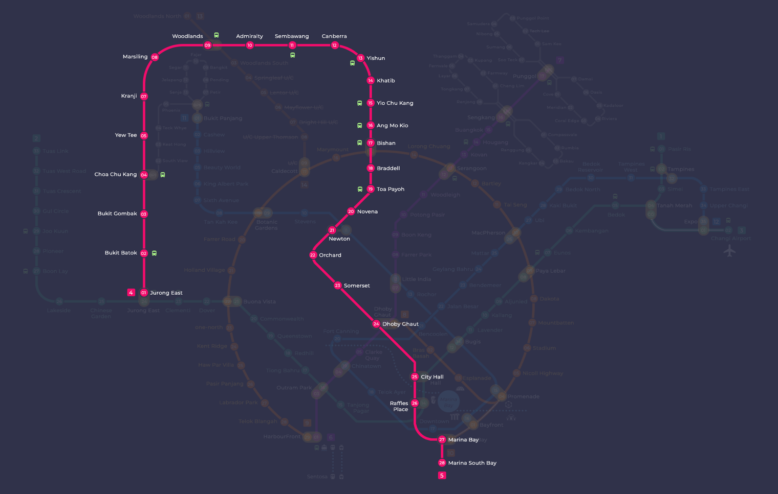
Yio Chu Kang MRT station at a glance
| Station codes | NS15 |
|---|---|
| Lines | North South Line |
| Line colour | Red line (North South Line) |
| Interchange | No, single line station |
| Chinese name | 杨厝港 |
| Tamil name | இயோ சூ காங் |
| Next stations | |
| Train times | North South Line: first train leaves the terminus at 5:16 AM, last train 11:48 PM Full first and last train guide |
See Yio Chu Kang on the map. The interactive map opens with this station highlighted, so you can trace the route from where you are.
From Yio Chu Kang, travelling one stop north brings you to Khatib station, while one stop south takes you to Ang Mo Kio station, where you can transfer to the Cross Island Line. The North South Line runs the full length of the island, so passengers can reach the city centre, Jurong East, and points in between without changing trains. For longer journeys or access to other lines, Ang Mo Kio is the nearest interchange option.
The area around the station is a typical Singapore heartland neighbourhood, with HDB blocks, local shops, and eating houses within easy walking distance. Yio Chu Kang Road runs nearby, lined with small businesses and amenities that cater to the local community. While there are no major tourist landmarks immediately at the station, the surrounding estate offers a relaxed, everyday Singaporean residential environment that is well served by local amenities and neighbourhood facilities.
Around Yio Chu Kang MRT station
Yio Chu Kang station sits in a largely residential neighbourhood in northern Singapore, well served by the adjacent bus interchange. The area is home to Nanyang Polytechnic and Yio Chu Kang Stadium, giving it a mix of educational, sporting and community facilities alongside housing estates.
| Place | Type | Distance | Why go |
|---|---|---|---|
| Yio Chu Kang Bus Interchange | Bus interchange | About 50 m (~1 min walk) | Catch local bus services to destinations across Singapore. |
| Yio Chu Kang Stadium | Stadium | About 250 m (~4 min walk) | Watch or participate in sporting events and activities. |
| Nanyang Polytechnic | College | About 450 m (~7 min walk) | Study, attend courses or visit the polytechnic campus. |
| North Canteen | Food centre | About 490 m (~8 min walk) | Grab a meal at this campus food centre. |
| Wet.Market | Market / hawker centre | About 490 m (~8 min walk) | Shop for fresh produce and daily groceries. |
| Food Connect | Food centre | About 490 m (~8 min walk) | Find a variety of cooked food stalls for a meal. |
| Koufu | Food centre | About 520 m (~8 min walk) | Enjoy a range of food options at this food court operator. |
| Ang Mo Kio Public Library | Library | About 780 m (~13 min walk) | Borrow books, study or access library resources. |
Places and straight-line distances from OpenStreetMap data (© OpenStreetMap contributors). Actual walking routes may be longer.
How to get to Yio Chu Kang by MRT
Worked out from the network map. Stop counts are station to station and do not include walking or waiting time.
| From Changi Airport | Take the East West Line from Changi Airport to Paya Lebar (6 stops), then change to the Circle Line from Paya Lebar to Bishan (6 stops), then change to the North South Line from Bishan to Yio Chu Kang (2 stops). About 14 stops with 2 changes. |
|---|---|
| From Orchard | Take the North South Line from Orchard to Yio Chu Kang (7 stops). About 7 stops, no changes. |
| From City Hall | Take the North South Line from City Hall to Yio Chu Kang (10 stops). About 10 stops, no changes. |
| From Jurong East | Take the North South Line from Jurong East to Yio Chu Kang (13 stops). About 13 stops, no changes. |
| From Woodlands | Take the North South Line from Woodlands to Yio Chu Kang (6 stops). About 6 stops, no changes. |
| From HarbourFront | Take the North East Line from HarbourFront to Dhoby Ghaut (4 stops), then change to the North South Line from Dhoby Ghaut to Yio Chu Kang (9 stops). About 13 stops with 1 change. |
Fares from Yio Chu Kang MRT station
A trip from Yio Chu Kang to Changi Airport (about 25 km) costs S$2.40 on an adult SimplyGo or EZ-Link card. Fares are charged by distance, so the table below shows the estimated adult card fare from Yio Chu Kang to the main hubs, the early bird fare for journeys that start before 7.45am on weekdays, and the fare that applies from 26 December 2026.
| To | Distance | Adult card | Before 7.45am | From 26 Dec 2026 |
|---|---|---|---|---|
| Changi Airport | about 25 km, 14 stops | S$2.40 | S$1.90 | S$2.53 |
| Orchard | about 10 km, 7 stops | S$1.90 | S$1.40 | S$2.03 |
| City Hall | about 13 km, 10 stops | S$2.02 | S$1.52 | S$2.15 |
| Raffles Place | about 14 km, 11 stops | S$2.07 | S$1.57 | S$2.20 |
| Jurong East | about 29 km, 13 stops | S$2.45 | S$1.95 | S$2.58 |
| Woodlands | about 14 km, 6 stops | S$2.02 | S$1.52 | S$2.15 |
| HarbourFront | about 18 km, 13 stops | S$2.20 | S$1.70 | S$2.33 |
| Marina Bay | about 15 km, 13 stops | S$2.11 | S$1.61 | S$2.24 |
Estimated from the route distance between stations and the Public Transport Council fare table in force from 27 December 2025. The exact fare can differ by one band. Cash fares are higher. Use the fare calculator for any other journey, or check your fare on the SimplyGo app.
Tips for using Yio Chu Kang MRT station
- Yio Chu Kang Bus Interchange is just outside the station, making it easy to connect to bus services for destinations not directly served by the MRT.
- Nanyang Polytechnic and the food centres on its campus are a manageable walk of around seven to eight minutes, though taking a bus from the interchange can save time, especially in hot weather.
- Yio Chu Kang Stadium is a short walk of about four minutes and is straightforward to reach on foot from the station.
- During morning and evening peak hours, the station and bus interchange can be busy, so allow a little extra time if you are making onward connections.
All stations on the North South Line
In order along the line, with Yio Chu Kang marked. Stations with their own guide are linked.
| Code | Station | Interchange |
|---|---|---|
| NS1 | Jurong East | EW / NS |
| NS2 | Bukit Batok | None |
| NS3 | Bukit Gombak | None |
| NS4 | Choa Chu Kang | NS / BP |
| NS5 | Yew Tee | None |
| NS7 | Kranji | None |
| NS8 | Marsiling | None |
| NS9 | Woodlands | NS / TE |
| NS10 | Admiralty | None |
| NS11 | Sembawang | None |
| NS12 | Canberra | None |
| NS13 | Yishun | None |
| NS14 | Khatib | None |
| NS15 | Yio Chu Kang (you are here) | None |
| NS16 | Ang Mo Kio | None |
| NS17 | Bishan | NS / CC |
| NS18 | Braddell | None |
| NS19 | Toa Payoh | None |
| NS20 | Novena | None |
| NS21 | Newton | NS / DT |
| NS22 | Orchard | TE / NS |
| NS23 | Somerset | None |
| NS24 | Dhoby Ghaut | NS / NE / CC |
| NS25 | City Hall | EW / NS |
| NS26 | Raffles Place | NS / EW |
| NS27 | Marina Bay | CE / TE / NS |
| NS28 | Marina South Pier | None |
Read the full North South Line guide.
Yio Chu Kang MRT station: common questions
Which line is Yio Chu Kang MRT station on?
Yio Chu Kang is on the North South Line. Its station code is NS15.
Is Yio Chu Kang an interchange station?
No. Yio Chu Kang is served by the North South Line only. The nearest interchange is shown in the next stations row above.
What time is the first and last train at Yio Chu Kang?
Times below are for the first and last train leaving the line terminus; trains reach Yio Chu Kang a few minutes later depending on its position on the line. North South Line first train 5:16 AM, last train 11:48 PM. Check the operator for holiday changes.
What is near Yio Chu Kang MRT station?
Nearby places include Yio Chu Kang Bus Interchange (approximately 50 m away), Yio Chu Kang Stadium (approximately 250 m), Nanyang Polytechnic (approximately 450 m) and several food centres on the polytechnic campus, as well as Ang Mo Kio Public Library at approximately 780 m.
Where is the nearest food centre to Yio Chu Kang station?
The closest food options are the North Canteen, Wet.Market and Food Connect, all located on or near the Nanyang Polytechnic campus at approximately 490 m from the station, roughly an eight-minute walk.
How far is Nanyang Polytechnic from Yio Chu Kang MRT station?
Nanyang Polytechnic is approximately 450 m from Yio Chu Kang station, which is roughly a seven-minute walk, though actual walking time may vary depending on your route.
How do I get to Yio Chu Kang from Changi Airport by MRT?
Take the East West Line from Changi Airport to Paya Lebar (6 stops), then change to the Circle Line from Paya Lebar to Bishan (6 stops), then change to the North South Line from Bishan to Yio Chu Kang (2 stops). About 14 stops with 2 changes.
Sources: station codes, line colours and interchanges from the LTA rail system map; operating hours from SMRT and SBS Transit. Last reviewed September 2026.
News and guides mentioning Yio Chu Kang
- MRT Station Codes and Interchange Stations Explained 31 Aug 2026
- North-South Line Map 11 Aug 2023
Plan the rest of the trip
Every station on the North South Line is listed on its line guide, with the full route and interchanges. For times, see the first and last train guide, and for the whole network in one view use the interactive Singapore MRT map or the PDF map.