
Farrer Road MRT Station
Farrer Road MRT station is a station on the Circle Line, carrying the station code CC20. It sits within a quiet, established residential area in the central region of Singapore, serving the surrounding neighbourhoods of low-rise housing estates and private residential developments. The station provides a convenient rail connection for the people who live in this part of the city, giving them straightforward access to other parts of Singapore via the Circle Line.
Farrer Road on the Circle Line map
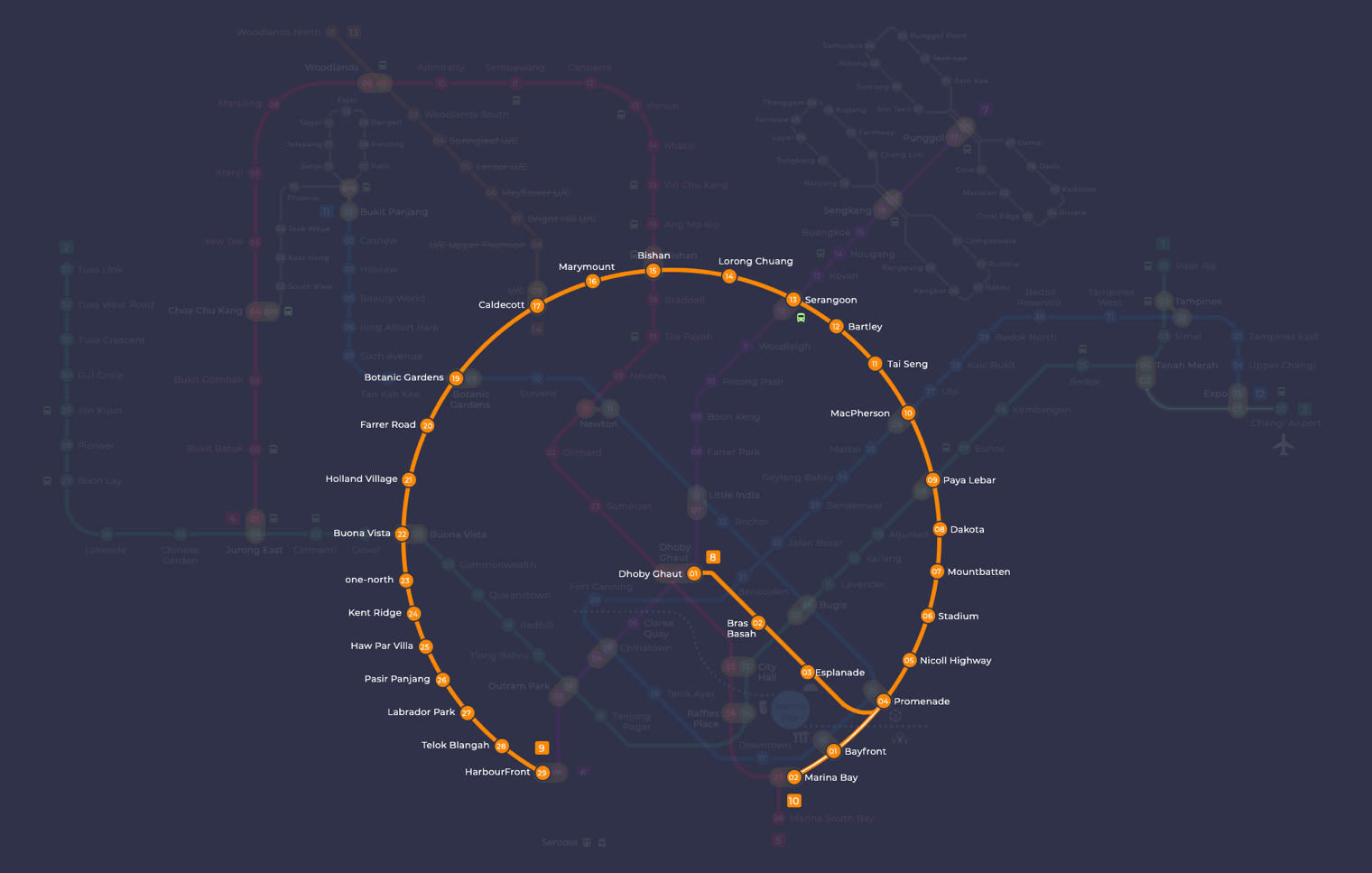
Farrer Road MRT station at a glance
| Station codes | CC20 |
|---|---|
| Lines | Circle Line |
| Line colour | Yellow line (Circle Line) |
| Interchange | No, single line station |
| Chinese name | 花拉路 |
| Tamil name | ஃபேரர் சாலை |
| Next stations | |
| Train times | Circle Line: first train leaves the terminus at 5:37 AM, last train 11:56 PM Full first and last train guide |
See Farrer Road on the map. The interactive map opens with this station highlighted, so you can trace the route from where you are.
As a non-interchange station, Farrer Road does not offer direct line transfers on site. Travelling along the Circle Line, the two neighbouring stations are Botanic Gardens (CC19) and Holland Village (CC21). At Botanic Gardens, passengers can switch to the Downtown Line, while Holland Village connects onward to further Circle Line destinations. These connections make it practical to reach a wide range of areas across Singapore without needing to travel far from Farrer Road itself.
The station sits close to the Farrer Road area, which is characterised by tree-lined streets and long-established private housing. The surrounding neighbourhood has a calm, residential feel with local shops and eateries within walking distance. The Botanic Gardens is reachable on foot or by a short ride to the adjacent station. The area around the station itself is largely residential, making it a relatively peaceful part of central Singapore with good access to everyday amenities.
Around Farrer Road MRT station
Farrer Road station sits within a quiet, established residential district characterised by landed homes, private estates and low-rise apartment blocks. The area borders the Singapore Botanic Gardens, bringing attractions such as the National Orchid Garden and the Forest Discovery Centre within walking reach. A cluster of neighbourhood shopping malls and Empress Market serve the everyday needs of local residents.
| Place | Type | Distance | Why go |
|---|---|---|---|
| Empress Market | Market / hawker centre | About 250 m (~4 min walk) | Visit for local produce, cooked food stalls and everyday market shopping. |
| Botanical Art Gallery | Attraction | About 430 m (~7 min walk) | Visit to view botanical and nature-themed artwork and illustrations. |
| Forest Discovery Centre | Attraction | About 540 m (~9 min walk) | Visit to learn about forest ecosystems through interactive displays and exhibits. |
| King's Arcade | Shopping mall | About 740 m (~12 min walk) | Visit for neighbourhood retail shops, services and casual dining options. |
| Crown Centre | Shopping mall | About 740 m (~12 min walk) | Visit for a small selection of shops and services in a local setting. |
| Coronation Shopping Plaza | Shopping mall | About 760 m (~12 min walk) | Visit for supermarket shopping, food options and everyday retail needs. |
| National Orchid Garden | Attraction | About 870 m (~14 min walk) | Visit to explore a celebrated collection of orchid species and hybrids. |
| Burkill Hall | Museum | About 890 m (~14 min walk) | Visit to see a heritage colonial building housing botanical history and collections. |
Places and straight-line distances from OpenStreetMap data (© OpenStreetMap contributors). Actual walking routes may be longer.
How to get to Farrer Road by MRT
Worked out from the network map. Stop counts are station to station and do not include walking or waiting time.
| From Changi Airport | Take the East West Line from Changi Airport to Paya Lebar (6 stops), then change to the Circle Line from Paya Lebar to Farrer Road (10 stops). About 16 stops with 1 change. |
|---|---|
| From Orchard | Take the Thomson East Coast Line from Orchard to Caldecott (4 stops), then change to the Circle Line from Caldecott to Farrer Road (2 stops). About 6 stops with 1 change. |
| From City Hall | Take the North South Line from City Hall to Newton (4 stops), then change to the Downtown Line from Newton to Botanic Gardens (2 stops), then change to the Circle Line from Botanic Gardens to Farrer Road (1 stop). About 7 stops with 2 changes. |
| From Jurong East | Take the East West Line from Jurong East to Buona Vista (3 stops), then change to the Circle Line from Buona Vista to Farrer Road (2 stops). About 5 stops with 1 change. |
| From Woodlands | Take the Thomson East Coast Line from Woodlands to Caldecott (7 stops), then change to the Circle Line from Caldecott to Farrer Road (2 stops). About 9 stops with 1 change. |
| From HarbourFront | Take the Circle Line from HarbourFront to Farrer Road (9 stops). About 9 stops, no changes. |
Fares from Farrer Road MRT station
A trip from Farrer Road to Changi Airport (about 28 km) costs S$2.44 on an adult SimplyGo or EZ-Link card. Fares are charged by distance, so the table below shows the estimated adult card fare from Farrer Road to the main hubs, the early bird fare for journeys that start before 7.45am on weekdays, and the fare that applies from 26 December 2026.
| To | Distance | Adult card | Before 7.45am | From 26 Dec 2026 |
|---|---|---|---|---|
| Changi Airport | about 28 km, 16 stops | S$2.44 | S$1.94 | S$2.57 |
| Orchard | about 11 km, 6 stops | S$1.90 | S$1.40 | S$2.03 |
| City Hall | about 8 km, 7 stops | S$1.75 | S$1.25 | S$1.88 |
| Raffles Place | about 11 km, 9 stops | S$1.94 | S$1.44 | S$2.07 |
| Jurong East | about 9 km, 5 stops | S$1.82 | S$1.32 | S$1.95 |
| Woodlands | about 19 km, 9 stops | S$2.27 | S$1.77 | S$2.40 |
| HarbourFront | about 11 km, 9 stops | S$1.90 | S$1.40 | S$2.03 |
| Marina Bay | about 15 km, 13 stops | S$2.11 | S$1.61 | S$2.24 |
Estimated from the route distance between stations and the Public Transport Council fare table in force from 27 December 2025. The exact fare can differ by one band. Cash fares are higher. Use the fare calculator for any other journey, or check your fare on the SimplyGo app.
Tips for using Farrer Road MRT station
- Empress Market is the closest food option at roughly 4 minutes on foot, making it a convenient first stop before or after your journey.
- The Botanic Gardens attractions, including the National Orchid Garden and Burkill Hall, are at the farther end of the walkable range at around 14 minutes, so allow extra time if visiting both.
- The three shopping malls, King's Arcade, Crown Centre and Coronation Shopping Plaza, are all roughly 12 minutes away on foot and are close to one another, so they can be combined in a single trip.
- At peak hours the station and surrounding roads can be busier, so build in a little extra time when planning connections or walking to destinations further away.
All stations on the Circle Line
In order along the line, with Farrer Road marked. Stations with their own guide are linked.
| Code | Station | Interchange |
|---|---|---|
| CC1 | Dhoby Ghaut | NS / NE / CC |
| CC2 | Bras Basah | None |
| CC3 | Esplanade | None |
| CC4 | Promenade | CC / DT |
| CC5 | Nicoll Highway | None |
| CC6 | Stadium | None |
| CC7 | Mountbatten | None |
| CC8 | Dakota | None |
| CC9 | Paya Lebar | CC / EW |
| CC10 | MacPherson | CC / DT |
| CC11 | Tai Seng | None |
| CC12 | Bartley | None |
| CC13 | Serangoon | CC / NE |
| CC14 | Lorong Chuan | None |
| CC15 | Bishan | NS / CC |
| CC16 | Marymount | None |
| CC17 | Caldecott | CC / TE |
| CC19 | Botanic Gardens | DT / CC |
| CC20 | Farrer Road (you are here) | None |
| CC21 | Holland Village | None |
| CC22 | Buona Vista | EW / CC |
| CC23 | one-north | None |
| CC24 | Kent Ridge | None |
| CC25 | Haw Par Villa | None |
| CC26 | Pasir Panjang | None |
| CC27 | Labrador Park | None |
| CC28 | Telok Blangah | None |
| CC29 | HarbourFront | CC / NE |
| CC30 | Keppel | None |
| CC31 | Cantonment | None |
| CC32 | Prince Edward Road | None |
Read the full Circle Line guide.
Farrer Road MRT station: common questions
Which line is Farrer Road MRT station on?
Farrer Road is on the Circle Line. Its station code is CC20.
Is Farrer Road an interchange station?
No. Farrer Road is served by the Circle Line only. The nearest interchange is shown in the next stations row above.
What time is the first and last train at Farrer Road?
Times below are for the first and last train leaving the line terminus; trains reach Farrer Road a few minutes later depending on its position on the line. Circle Line first train 5:37 AM, last train 11:56 PM. Check the operator for holiday changes.
What is near Farrer Road MRT station?
The area offers a mix of food, shopping and nature attractions. Nearby places include Empress Market, the Botanical Art Gallery, Forest Discovery Centre, King's Arcade, Crown Centre, Coronation Shopping Plaza, the National Orchid Garden and Burkill Hall.
Which food centre or market is closest to Farrer Road station?
Empress Market is the closest, at approximately 250 metres straight-line distance, or roughly a 4-minute walk from the station.
How far is the National Orchid Garden from Farrer Road station?
The National Orchid Garden is approximately 870 metres away in a straight line, which is around a 14-minute walk from the station.
How do I get to Farrer Road from Changi Airport by MRT?
Take the East West Line from Changi Airport to Paya Lebar (6 stops), then change to the Circle Line from Paya Lebar to Farrer Road (10 stops). About 16 stops with 1 change.
Sources: station codes, line colours and interchanges from the LTA rail system map; operating hours from SMRT and SBS Transit. Last reviewed September 2026.
Plan the rest of the trip
Every station on the Circle Line is listed on its line guide, with the full route and interchanges. For times, see the first and last train guide, and for the whole network in one view use the interactive Singapore MRT map or the PDF map.