
Boon Lay MRT Station
Boon Lay MRT station is an elevated stop on the East West Line, carrying the code EW27, and stands along Boon Lay Way in Jurong West, in the west of Singapore. It forms the Boon Lay Integrated Transport Hub together with Boon Lay Bus Interchange and Jurong Point shopping centre, so passengers can move between trains, buses and shops within one connected complex.
Boon Lay on the East West Line map
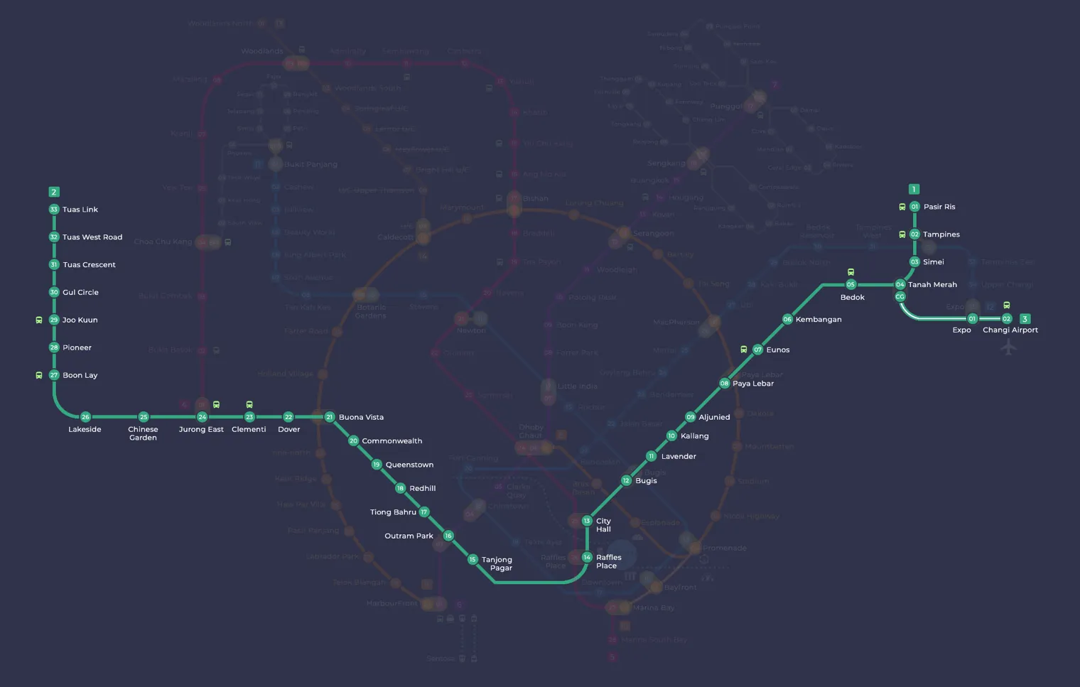
Boon Lay MRT station at a glance
| Station codes | EW27 |
|---|---|
| Lines | East West Line |
| Line colour | Green line (East West Line) |
| Interchange | No, single line station |
| Chinese name | 文礼 |
| Tamil name | பூன் லே |
| Opened | 6 July 1990 (36 years ago) |
| Operator | SMRT Trains |
| Station type | Elevated |
| Platforms | 2 (1 island platform) |
| Address | 301 Boon Lay Way, Singapore 649846 |
| Daily ridership | About 41,195 passengers a day (2024) |
| Next stations | |
| Train times | East West Line: first train leaves the terminus at 5:19 AM, last train 11:23 PM Full first and last train guide |
Opening date, operator and ridership figures are LTA data as recorded on Wikipedia.
See Boon Lay on the map. The interactive map opens with this station highlighted, so you can trace the route from where you are.
Many of its passengers live in the surrounding Jurong West estates and board here to travel east along the line, while others arrive by bus and change to the train at the interchange next door. Shoppers heading to Jurong Point and The Centris add to the daily flow. The station is also set to become an interchange with the Jurong Region Line, which is expected to open in the middle of 2028, with the new platforms being built along Jurong West Street 64.
History of Boon Lay MRT station
Boon Lay MRT station opened on 6 July 1990 and was the final station completed on Singapore’s original MRT network. During planning it was called Jurong West, and work was briefly put on hold before being given the go-ahead in 1987. For almost two decades it was the western end of the East West Line, until the extension to Joo Koon opened in 2009 and helped ease crowding here.
Inside Boon Lay MRT station
The platforms have half-height screen doors, fitted in 2012, and large high-volume, low-speed fans overhead to improve airflow. The station also displays a mural from SMRT’s Comic Connect programme by local artist Muhammed Nurman bin Selamat, showing Chew Boon Lay, the businessman the area is named after, alongside early 20th-century rubber plantations and Tuas Pek Kong Keng Temple.
For everyday errands, a lot is within a short walk of the platforms. Jurong Point is about two minutes away for shopping and meals, and Jurong West Library is around four minutes on foot, which makes it a convenient stop for students and readers. Jurong Central Park, also about four minutes away, offers open space for a walk or a break between appointments, while Jurong Medical Centre is roughly five minutes from the station for those visiting for treatment or check-ups.
Around Boon Lay MRT station
Boon Lay station sits at the heart of a busy mixed-use area in Jurong West, combining large shopping malls with residential blocks and community facilities. The area is anchored by Jurong Point and The Centris, both within a very short walk of the station. Nearby amenities include a bus interchange, a library, a medical centre and a park, making the area well served for everyday needs.
| Place | Type | Distance | Why go |
|---|---|---|---|
| Jurong Point | Shopping mall | About 110 m (~2 min walk) | Visit Jurong Point for a wide range of retail shops, supermarkets and dining options. |
| Boon Lay Interchange | Bus interchange | About 110 m (~2 min walk) | Use Boon Lay Interchange to connect to bus routes serving the surrounding Jurong West area. |
| The Centris | Shopping mall | About 120 m (~2 min walk) | Visit The Centris for additional shopping, dining and lifestyle options close to the station. |
| Kopitiam | Food centre | About 190 m (~3 min walk) | Head to Kopitiam for local hawker-style meals and drinks in a food centre setting. |
| Jurong Central Park | Park | About 230 m (~4 min walk) | Visit Jurong Central Park for outdoor leisure, greenery and a relaxed open-air environment. |
| Jurong West Library | Library | About 240 m (~4 min walk) | Use Jurong West Library to borrow books, study or access community programmes and resources. |
| Jurong Medical Centre | Hospital | About 280 m (~5 min walk) | Visit Jurong Medical Centre for medical consultations, specialist services and healthcare needs. |
| Pioneer Mall | Shopping mall | About 1020 m (~17 min walk) | Pioneer Mall offers further retail and dining options if you need more variety further afield. |
Places and straight-line distances from OpenStreetMap data (© OpenStreetMap contributors). Actual walking routes may be longer.
How to get to Boon Lay by MRT
Worked out from the network map. Stop counts are station to station and do not include walking or waiting time.
| From Changi Airport | Take the East West Line from Changi Airport to Boon Lay (25 stops). About 25 stops, no changes. |
|---|---|
| From Orchard | Take the Thomson East Coast Line from Orchard to Outram Park (3 stops), then change to the East West Line from Outram Park to Boon Lay (11 stops). About 14 stops with 1 change. |
| From City Hall | Take the East West Line from City Hall to Boon Lay (14 stops). About 14 stops, no changes. |
| From Jurong East | Take the East West Line from Jurong East to Boon Lay (3 stops). About 3 stops, no changes. |
| From Woodlands | Take the North South Line from Woodlands to Jurong East (7 stops), then change to the East West Line from Jurong East to Boon Lay (3 stops). About 10 stops with 1 change. |
| From HarbourFront | Take the North East Line from HarbourFront to Outram Park (1 stop), then change to the East West Line from Outram Park to Boon Lay (11 stops). About 12 stops with 1 change. |
Fares from Boon Lay MRT station
A trip from Boon Lay to Changi Airport (about 41 km) costs S$2.57 on an adult SimplyGo or EZ-Link card. Fares are charged by distance, so the table below shows the estimated adult card fare from Boon Lay to the main hubs, the early bird fare for journeys that start before 7.45am on weekdays, and the fare that applies from 26 December 2026.
| To | Distance | Adult card | Before 7.45am | From 26 Dec 2026 |
|---|---|---|---|---|
| Changi Airport | about 41 km, 25 stops | S$2.57 | S$2.07 | S$2.70 |
| Orchard | about 22 km, 14 stops | S$2.33 | S$1.83 | S$2.46 |
| City Hall | about 22 km, 14 stops | S$2.33 | S$1.83 | S$2.46 |
| Raffles Place | about 21 km, 13 stops | S$2.30 | S$1.80 | S$2.43 |
| Jurong East | about 5 km, 3 stops | S$1.49 | S$0.99 | S$1.62 |
| Woodlands | about 21 km, 10 stops | S$2.30 | S$1.80 | S$2.43 |
| HarbourFront | about 22 km, 12 stops | S$2.33 | S$1.83 | S$2.46 |
| Marina Bay | about 22 km, 14 stops | S$2.33 | S$1.83 | S$2.46 |
Estimated from the route distance between stations and the Public Transport Council fare table in force from 27 December 2025. The exact fare can differ by one band. Cash fares are higher. Use the fare calculator for any other journey, or check your fare on the SimplyGo app.
Tips for using Boon Lay MRT station
- Jurong Point, The Centris and Boon Lay Interchange are all within roughly two minutes on foot from the station, so these are easy to reach without planning extra time.
- Jurong Central Park, Jurong West Library and Jurong Medical Centre are each around four to five minutes on foot, but allow a little more time during hot or wet weather.
- Pioneer Mall is roughly 17 minutes on foot at straight-line distance, so taking a bus from Boon Lay Interchange is a more comfortable option than walking.
- During peak morning and evening hours the area around the station and interchange can be busy, so allow extra time if you are making onward bus connections.
All stations on the East West Line
In order along the line, with Boon Lay marked. Stations with their own guide are linked.
| Code | Station | Interchange |
|---|---|---|
| EW1 | Pasir Ris | None |
| EW2 | Tampines | EW / DT |
| EW3 | Simei | None |
| EW4 | Tanah Merah | None |
| EW5 | Bedok | None |
| EW6 | Kembangan | None |
| EW7 | Eunos | None |
| EW8 | Paya Lebar | CC / EW |
| EW9 | Aljunied | None |
| EW10 | Kallang | None |
| EW11 | Lavender | None |
| EW12 | Bugis | DT / EW |
| EW13 | City Hall | EW / NS |
| EW14 | Raffles Place | NS / EW |
| EW15 | Tanjong Pagar | None |
| EW16 | Outram Park | TE / EW / NE |
| EW17 | Tiong Bahru | None |
| EW18 | Redhill | None |
| EW19 | Queenstown | None |
| EW20 | Commonwealth | None |
| EW21 | Buona Vista | EW / CC |
| EW22 | Dover | None |
| EW23 | Clementi | None |
| EW24 | Jurong East | EW / NS |
| EW25 | Chinese Garden | None |
| EW26 | Lakeside | None |
| EW27 | Boon Lay (you are here) | None |
| EW28 | Pioneer | None |
| EW29 | Joo Koon | None |
| EW30 | Gul Circle | None |
| EW31 | Tuas Crescent | None |
| EW32 | Tuas West Road | None |
| EW33 | Tuas Link | None |
Read the full East West Line guide.
Boon Lay MRT station: common questions
Which line is Boon Lay MRT station on?
Boon Lay is on the East West Line. Its station code is EW27.
Is Boon Lay an interchange station?
No. Boon Lay is served by the East West Line only. The nearest interchange is shown in the next stations row above.
What time is the first and last train at Boon Lay?
Times below are for the first and last train leaving the line terminus; trains reach Boon Lay a few minutes later depending on its position on the line. East West Line first train 5:19 AM, last train 11:23 PM. Check the operator for holiday changes.
What is near Boon Lay MRT station?
Boon Lay station is close to Jurong Point and The Centris shopping malls, Boon Lay Interchange, a Kopitiam food centre, Jurong Central Park, Jurong West Library and Jurong Medical Centre, all within approximately five minutes on foot. Pioneer Mall is also reachable, though it is around 1,020 metres away.
Which mall or food centre is closest to Boon Lay station?
Jurong Point and The Centris are the closest shopping malls, both approximately 110 to 120 metres from the station and roughly a two-minute walk. The Kopitiam food centre is a little further at approximately 190 metres, or about three minutes on foot.
How far is Jurong Medical Centre from Boon Lay station?
Jurong Medical Centre is approximately 280 metres from Boon Lay station in a straight line, which is roughly a five-minute walk. Distances are approximate and may vary depending on the route taken.
How do I get to Boon Lay from Changi Airport by MRT?
Take the East West Line from Changi Airport to Boon Lay (25 stops). About 25 stops, no changes.
Sources: station codes, line colours and interchanges from the LTA rail system map; operating hours from SMRT and SBS Transit. Last reviewed October 2026.
News and guides mentioning Boon Lay
- Deepavali Eve Train Extensions: Which Lines Run Later on 8 November 6 Nov 2026
- Jurong Region Line Stage 1: what to expect mid-2028 6 Nov 2026
- Lakeside MRT Delay: How to Beat the Morning Rush Queues 22 Oct 2026
- Future MRT Map Singapore: Every New Line and Extension to 2040 21 Oct 2026
Plan the rest of the trip
Every station on the East West Line is listed on its line guide, with the full route and interchanges. For times, see the first and last train guide, and for the whole network in one view use the interactive Singapore MRT map or the PDF map.
Exits and buses at Boon Lay station
Bus stops within 250 m of Boon Lay station
| Bus stop | Stop code | Services | From station |
|---|---|---|---|
| Boon Lay Stn | 22579 | NoServices | 103 m |
| Opp Boon Lay Stn | 22571 | NR5 | 146 m |
| Opposite Blk 662C | 22499 | 172, 178, 180, 180A, 187, 240, 240M, 251, 258, 974, 974A | 180 m |
| Blk 662D | 22491 | 5N, 172, 178, 180, 187, 240, 251, 974, NR5 | 213 m |
Exits and bus services come from OpenStreetMap and can change when roads or routes are revised; check the board at the stop or the operator app before relying on a service late at night. For the nearest station to where you are now, use the MRT near me finder.
Places to visit from Boon Lay station
See every guide on how to get to Singapore's attractions, hospitals and malls by MRT, with routes and fares from Changi Airport, Orchard and the city.
MRT routes from Boon Lay
Routes to Boon Lay: Changi Airport to Boon Lay | City Hall to Boon Lay | Orchard to Boon Lay | Raffles Place to Boon Lay.
More on the MRT routes hub.