
Queenstown MRT Station
Queenstown MRT station is a single-line station on the East West Line, carrying the station code EW19. It serves Queenstown, one of Singapore's older residential towns, made up largely of public housing estates and a mix of neighbourhood amenities. The station provides straightforward rail access for residents and visitors travelling through this established part of the city's southern corridor.
Queenstown on the East West Line map
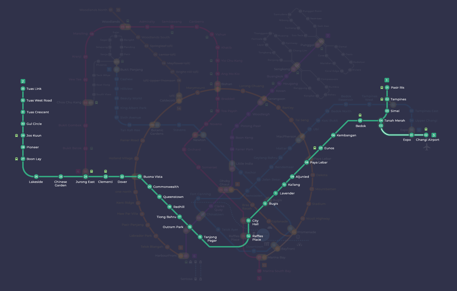
Queenstown MRT station at a glance
| Station codes | EW19 |
|---|---|
| Lines | East West Line |
| Line colour | Green line (East West Line) |
| Interchange | No, single line station |
| Chinese name | 女皇镇 |
| Tamil name | குவீன்ஸ்டவுன் |
| Next stations | |
| Train times | East West Line: first train leaves the terminus at 5:19 AM, last train 11:23 PM Full first and last train guide |
See Queenstown on the map. The interactive map opens with this station highlighted, so you can trace the route from where you are.
From Queenstown station, trains run eastward towards the city and westward out to Jurong. The two neighbouring stations are Redhill to the west and Commonwealth to the east, both also on the East West Line. Queenstown is not an interchange station, so passengers needing connections to other MRT lines should plan to travel to a nearby interchange such as Outram Park, which is accessible within a few stops along the same line.
The area around the station is predominantly residential, with local shops, hawker centres and neighbourhood parks within walking distance. Alexandra Road runs close by, giving access to various retail and food options. The general character of the surrounding streets is quiet and low-rise, typical of a mature Singapore housing estate, making it a practical rather than tourist-oriented stop on the East West Line.
Around Queenstown MRT station
Queenstown is a mature residential town, one of Singapore's oldest housing estates, with a mix of HDB blocks, neighbourhood amenities and recreational facilities. The area around the station is well served by food centres such as Margaret Drive Hawker Centre and Mei Ling Market and Food Centre, alongside leisure options like Queenstown Sports Complex. A handful of shopping malls, including Anchorpoint and Queensway Shopping Centre, sit within walking distance for everyday retail needs.
| Place | Type | Distance | Why go |
|---|---|---|---|
| Margaret Drive Hawker Centre | Food centre | About 350 m (~6 min walk) | Visit for local hawker food in a traditional neighbourhood food centre setting. |
| Mei Ling Market and Food Centre | Food centre | About 380 m (~6 min walk) | Head here for a wide variety of affordable cooked food and market produce. |
| The Young Ones Eating House | Food centre | About 390 m (~6 min walk) | A casual eating house option for a quick, no-frills meal nearby. |
| Queenstown Sports Complex | Stadium | About 410 m (~7 min walk) | Use the complex for sports, recreation and community fitness activities. |
| Queenstown Public Library | Library | About 450 m (~7 min walk) | Borrow books, study or access community library resources here. |
| Dawson Place | Shopping mall | About 590 m (~10 min walk) | A neighbourhood mall with everyday retail and dining options. |
| Anchorpoint | Shopping mall | About 670 m (~11 min walk) | A shopping centre with a range of sports goods and lifestyle stores. |
| Queensway Shopping Centre | Shopping mall | About 840 m (~14 min walk) | A popular destination for sporting goods, apparel and related retail. |
Places and straight-line distances from OpenStreetMap data (© OpenStreetMap contributors). Actual walking routes may be longer.
How to get to Queenstown by MRT
Worked out from the network map. Stop counts are station to station and do not include walking or waiting time.
| From Changi Airport | Take the East West Line from Changi Airport to Queenstown (17 stops). About 17 stops, no changes. |
|---|---|
| From Orchard | Take the Thomson East Coast Line from Orchard to Outram Park (3 stops), then change to the East West Line from Outram Park to Queenstown (3 stops). About 6 stops with 1 change. |
| From City Hall | Take the East West Line from City Hall to Queenstown (6 stops). About 6 stops, no changes. |
| From Jurong East | Take the East West Line from Jurong East to Queenstown (5 stops). About 5 stops, no changes. |
| From Woodlands | Take the North South Line from Woodlands to Jurong East (7 stops), then change to the East West Line from Jurong East to Queenstown (5 stops). About 12 stops with 1 change. |
| From HarbourFront | Take the North East Line from HarbourFront to Outram Park (1 stop), then change to the East West Line from Outram Park to Queenstown (3 stops). About 4 stops with 1 change. |
Fares from Queenstown MRT station
A trip from Queenstown to Changi Airport (about 27 km) costs S$2.43 on an adult SimplyGo or EZ-Link card. Fares are charged by distance, so the table below shows the estimated adult card fare from Queenstown to the main hubs, the early bird fare for journeys that start before 7.45am on weekdays, and the fare that applies from 26 December 2026.
| To | Distance | Adult card | Before 7.45am | From 26 Dec 2026 |
|---|---|---|---|---|
| Changi Airport | about 27 km, 17 stops | S$2.43 | S$1.93 | S$2.56 |
| Orchard | about 8 km, 6 stops | S$1.75 | S$1.25 | S$1.88 |
| City Hall | about 8 km, 6 stops | S$1.75 | S$1.25 | S$1.88 |
| Raffles Place | about 6 km, 5 stops | S$1.68 | S$1.18 | S$1.81 |
| Jurong East | about 9 km, 5 stops | S$1.86 | S$1.36 | S$1.99 |
| Woodlands | about 25 km, 12 stops | S$2.40 | S$1.90 | S$2.53 |
| HarbourFront | about 7 km, 4 stops | S$1.75 | S$1.25 | S$1.88 |
| Marina Bay | about 8 km, 6 stops | S$1.75 | S$1.25 | S$1.88 |
Estimated from the route distance between stations and the Public Transport Council fare table in force from 27 December 2025. The exact fare can differ by one band. Cash fares are higher. Use the fare calculator for any other journey, or check your fare on the SimplyGo app.
Tips for using Queenstown MRT station
- Margaret Drive Hawker Centre, Mei Ling Market and Food Centre, and The Young Ones Eating House are all within roughly six minutes on foot, making them convenient for a meal before or after your journey.
- Queenstown Sports Complex and Queenstown Public Library are around a seven-minute walk and easy to combine into a single outing on foot.
- Anchorpoint and Queensway Shopping Centre involve walks of around eleven to fourteen minutes respectively, so consider using local bus services if you prefer not to walk, especially in hot or wet weather.
- The station can get busy during morning and evening peak hours, so allow extra time if you are travelling to or from this area during rush periods.
All stations on the East West Line
In order along the line, with Queenstown marked. Stations with their own guide are linked.
| Code | Station | Interchange |
|---|---|---|
| EW1 | Pasir Ris | None |
| EW2 | Tampines | EW / DT |
| EW3 | Simei | None |
| EW4 | Tanah Merah | None |
| EW5 | Bedok | None |
| EW6 | Kembangan | None |
| EW7 | Eunos | None |
| EW8 | Paya Lebar | CC / EW |
| EW9 | Aljunied | None |
| EW10 | Kallang | None |
| EW11 | Lavender | None |
| EW12 | Bugis | DT / EW |
| EW13 | City Hall | EW / NS |
| EW14 | Raffles Place | NS / EW |
| EW15 | Tanjong Pagar | None |
| EW16 | Outram Park | TE / EW / NE |
| EW17 | Tiong Bahru | None |
| EW18 | Redhill | None |
| EW19 | Queenstown (you are here) | None |
| EW20 | Commonwealth | None |
| EW21 | Buona Vista | EW / CC |
| EW22 | Dover | None |
| EW23 | Clementi | None |
| EW24 | Jurong East | EW / NS |
| EW25 | Chinese Garden | None |
| EW26 | Lakeside | None |
| EW27 | Boon Lay | None |
| EW28 | Pioneer | None |
| EW29 | Joo Koon | None |
| EW30 | Gul Circle | None |
| EW31 | Tuas Crescent | None |
| EW32 | Tuas West Road | None |
| EW33 | Tuas Link | None |
Read the full East West Line guide.
Queenstown MRT station: common questions
Which line is Queenstown MRT station on?
Queenstown is on the East West Line. Its station code is EW19.
Is Queenstown an interchange station?
No. Queenstown is served by the East West Line only. The nearest interchange is shown in the next stations row above.
What time is the first and last train at Queenstown?
Times below are for the first and last train leaving the line terminus; trains reach Queenstown a few minutes later depending on its position on the line. East West Line first train 5:19 AM, last train 11:23 PM. Check the operator for holiday changes.
What is near Queenstown MRT station?
The area around Queenstown MRT station has several food centres, including Margaret Drive Hawker Centre and Mei Ling Market and Food Centre, as well as Queenstown Sports Complex, Queenstown Public Library and a few shopping malls such as Anchorpoint and Queensway Shopping Centre, all within approximate walking distance.
Which food centre or hawker centre is closest to Queenstown MRT station?
Margaret Drive Hawker Centre is the closest food centre, at approximately 350 metres straight-line distance, which is roughly a six-minute walk from the station.
How far is Queensway Shopping Centre from Queenstown MRT station?
Queensway Shopping Centre is approximately 840 metres away in a straight line, which works out to roughly a fourteen-minute walk from the station.
How do I get to Queenstown from Changi Airport by MRT?
Take the East West Line from Changi Airport to Queenstown (17 stops). About 17 stops, no changes.
Sources: station codes, line colours and interchanges from the LTA rail system map; operating hours from SMRT and SBS Transit. Last reviewed September 2026.
News and guides mentioning Queenstown
- Singapore MRT Art in Transit Programme Explained 13 Aug 2026
- Think Before You Complain: Feeding Kids on the MRT 25 Jul 2026
- 15 Eats to Try at Circle Line’s New CCL6 Stations 12 Jul 2026
Plan the rest of the trip
Every station on the East West Line is listed on its line guide, with the full route and interchanges. For times, see the first and last train guide, and for the whole network in one view use the interactive Singapore MRT map or the PDF map.