
Tampines MRT Station
Tampines MRT station stands in Tampines town centre in eastern Singapore, beside Tampines Avenue 4, Tampines Central 4 and Tampines Central 5. It is an interchange on two lines: the East West Line, where it carries the code EW2, and the Downtown Line, where it is DT32. The East West Line platforms are elevated, under the segmented dome-shaped roof found on several other raised stations in the east. The Downtown Line station is a separate building with no paid link to the older one, so passengers changing lines leave through the fare gates of one station before entering the other.
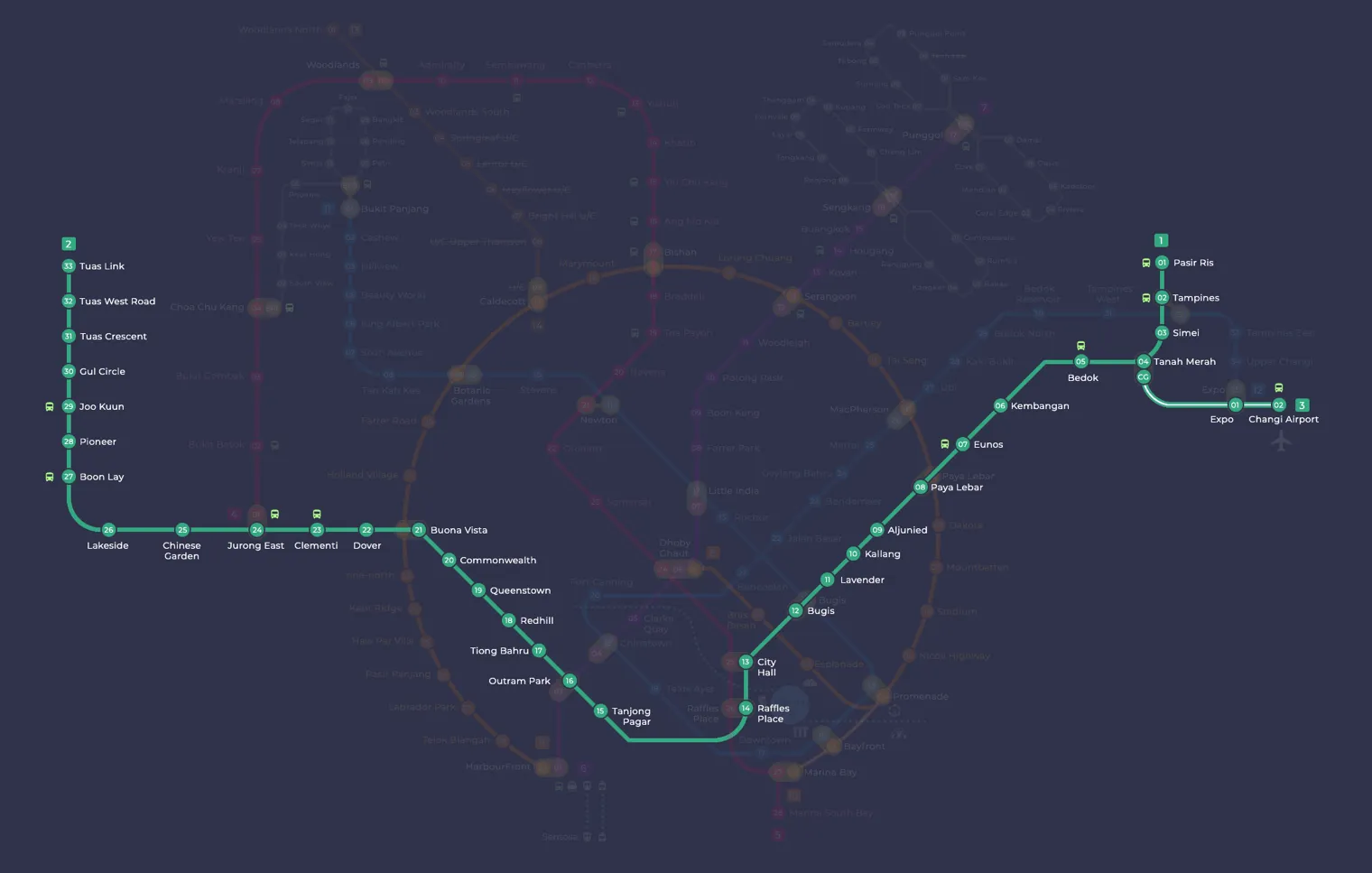
Tampines on the East West Line map
Tampines MRT station at a glance
| Station codes | EW2DT32 |
|---|---|
| Lines | East West Line Downtown Line |
| Line colour | Green line (East West Line) Blue line (Downtown Line) |
| Interchange | Yes, change between 2 lines here |
| Chinese name | 淡滨尼 |
| Tamil name | தெம்பினிஸ் |
| Opened | 16 December 1989 (36 years ago) |
| Operator | SMRT Trains and SBS Transit |
| Station type | Elevated |
| Platforms | 4 (2 island platforms) |
| Address | 20 Tampines Central 1, Singapore 529538 |
| Daily ridership | About 48,791 passengers a day (2024) |
| Next stations | |
| Train times | East West Line: first train leaves the terminus at 5:19 AM, last train 11:23 PM Downtown Line: first train leaves the terminus at 5:30 AM, last train 11:40 PM Full first and last train guide |
Opening date, operator and ridership figures are LTA data as recorded on Wikipedia.
See Tampines on the map. The interactive map opens with this station highlighted, so you can trace the route from where you are.
The station mainly serves people who live in Tampines and nearby Pasir Ris, many of whom use it to travel to work in the city. It is also busy with shoppers heading to the three large malls around it and with passengers transferring to buses at the Tampines and Tampines Concourse bus interchanges, both close to the station.
History of Tampines MRT station
The East West Line platforms opened on 16 December 1989, when the line was extended east to Pasir Ris, and residents welcomed the prospect of shorter journeys to their workplaces. Early plans for the network had proposed two separate stops here, called Tampines North and Tampines South, with the northern one as the end of the line. The Downtown Line platforms followed on 21 October 2017 as part of the line’s third stage, and the public could look around them at an open house a week earlier.
Inside Tampines MRT station
In 2002, Tampines MRT station was one of the first five stations on the network to be fitted with lifts, ramps and toilets for wheelchair users. The East West Line platforms have half-height screen doors, and in 2012 this became the first MRT station to have large, slow-turning ceiling fans installed above its platforms to improve air flow. Cyclists can use the sheltered bicycle parking added in 2009. On the Downtown Line side, look out for The Big Round & The Tall Long, an artwork by Studio Juju created for the network’s Art-in-Transit programme.
Most people use Tampines MRT station for shopping, food and bus connections, as almost everything is within a few minutes on foot:
- Tampines Interchange, about a minute’s walk away, for bus connections across the east.
- Tampines 1, Tampines Mall and Century Square, three shopping malls all within about 3 minutes of the station.
- Hawkers’ Street, a food centre roughly 2 minutes away, for an affordable meal.
- Our Tampines Gallery, a museum about the town around 6 minutes’ walk away.
Around Tampines MRT station
Tampines MRT station sits at the heart of one of Singapore's largest new towns, surrounded by a dense mix of retail, dining and residential activity. The area is well served by shopping malls including Tampines 1 and Century Square, alongside numerous food centres catering to the local community. Public transport connections are strong, with Tampines Interchange located just beside the station.
| Place | Type | Distance | Why go |
|---|---|---|---|
| Tampines Interchange | Bus interchange | About 60 m (~1 min walk) | Catch buses across Singapore from this major regional bus interchange. |
| Tampines 1 | Shopping mall | About 100 m (~2 min walk) | Browse a wide range of shops, eateries and entertainment options at this mall. |
| Hawkers' Street | Food centre | About 120 m (~2 min walk) | Try a variety of local street food dishes at this hawker-style food centre. |
| Malaysia Boleh | Food centre | About 130 m (~2 min walk) | Sample Malaysian-style dishes and local favourites at this food centre. |
| NTWU Canteen | Food centre | About 140 m (~2 min walk) | Grab an affordable meal at this canteen-style food centre. |
| Tampines Mall | Shopping mall | About 200 m (~3 min walk) | Shop, dine and run errands at this long-established neighbourhood mall. |
| Century Square | Shopping mall | About 210 m (~3 min walk) | Visit for shopping, dining and leisure in the heart of Tampines. |
| Our Tampines Gallery | Museum | About 390 m (~6 min walk) | Learn about the history and community life of the Tampines neighbourhood at this gallery. |
Places and straight-line distances from OpenStreetMap data (© OpenStreetMap contributors). Actual walking routes may be longer.
How to get to Tampines by MRT
Worked out from the network map. Stop counts are station to station and do not include walking or waiting time.
| From Changi Airport | Take the East West Line from Changi Airport to Tampines (4 stops). About 4 stops, no changes. |
|---|---|
| From Orchard | Take the North South Line from Orchard to City Hall (3 stops), then change to the East West Line from City Hall to Tampines (11 stops). About 14 stops with 1 change. |
| From City Hall | Take the East West Line from City Hall to Tampines (11 stops). About 11 stops, no changes. |
| From Jurong East | Take the East West Line from Jurong East to Tampines (22 stops). About 22 stops, no changes. |
| From Woodlands | Take the North South Line from Woodlands to Bishan (8 stops), then change to the Circle Line from Bishan to MacPherson (5 stops), then change to the Downtown Line from MacPherson to Tampines (6 stops). About 19 stops with 2 changes. |
| From HarbourFront | Take the North East Line from HarbourFront to Chinatown (2 stops), then change to the Downtown Line from Chinatown to Tampines (13 stops). About 15 stops with 1 change. |
Fares from Tampines MRT station
A trip from Tampines to Changi Airport (about 10 km) costs S$1.90 on an adult SimplyGo or EZ-Link card. Fares are charged by distance, so the table below shows the estimated adult card fare from Tampines to the main hubs, the early bird fare for journeys that start before 7.45am on weekdays, and the fare that applies from 26 December 2026.
| To | Distance | Adult card | Before 7.45am | From 26 Dec 2026 |
|---|---|---|---|---|
| Changi Airport | about 10 km, 4 stops | S$1.90 | S$1.40 | S$2.03 |
| Orchard | about 20 km, 14 stops | S$2.27 | S$1.77 | S$2.40 |
| City Hall | about 17 km, 11 stops | S$2.15 | S$1.65 | S$2.28 |
| Raffles Place | about 18 km, 12 stops | S$2.20 | S$1.70 | S$2.33 |
| Jurong East | about 34 km, 22 stops | S$2.50 | S$2.00 | S$2.63 |
| Woodlands | about 32 km, 19 stops | S$2.48 | S$1.98 | S$2.61 |
| HarbourFront | about 23 km, 15 stops | S$2.36 | S$1.86 | S$2.49 |
| Marina Bay | about 19 km, 13 stops | S$2.24 | S$1.74 | S$2.37 |
Estimated from the route distance between stations and the Public Transport Council fare table in force from 27 December 2025. The exact fare can differ by one band. Cash fares are higher. Use the fare calculator for any other journey, or check your fare on the SimplyGo app.
Tips for using Tampines MRT station
- Tampines Interchange is only a short walk from the station, making onward bus connections straightforward for destinations beyond walking distance.
- The three shopping malls nearest the station are all within roughly a 3-minute walk, so it is easy to visit more than one in a single trip.
- This station serves both the East West Line and the Downtown Line, so check which line your journey requires before passing through the fare gates.
- The area can get very busy during weekend afternoons and public holidays, so allow extra time when travelling to or from the station at peak periods.
All stations on the East West Line
In order along the line, with Tampines marked. Stations with their own guide are linked.
| Code | Station | Interchange |
|---|---|---|
| EW1 | Pasir Ris | None |
| EW2 | Tampines (you are here) | EW / DT |
| EW3 | Simei | None |
| EW4 | Tanah Merah | None |
| EW5 | Bedok | None |
| EW6 | Kembangan | None |
| EW7 | Eunos | None |
| EW8 | Paya Lebar | CC / EW |
| EW9 | Aljunied | None |
| EW10 | Kallang | None |
| EW11 | Lavender | None |
| EW12 | Bugis | DT / EW |
| EW13 | City Hall | EW / NS |
| EW14 | Raffles Place | NS / EW |
| EW15 | Tanjong Pagar | None |
| EW16 | Outram Park | TE / EW / NE |
| EW17 | Tiong Bahru | None |
| EW18 | Redhill | None |
| EW19 | Queenstown | None |
| EW20 | Commonwealth | None |
| EW21 | Buona Vista | EW / CC |
| EW22 | Dover | None |
| EW23 | Clementi | None |
| EW24 | Jurong East | EW / NS |
| EW25 | Chinese Garden | None |
| EW26 | Lakeside | None |
| EW27 | Boon Lay | None |
| EW28 | Pioneer | None |
| EW29 | Joo Koon | None |
| EW30 | Gul Circle | None |
| EW31 | Tuas Crescent | None |
| EW32 | Tuas West Road | None |
| EW33 | Tuas Link | None |
Read the full East West Line guide.
All stations on the Downtown Line
In order along the line, with Tampines marked. Stations with their own guide are linked.
| Code | Station | Interchange |
|---|---|---|
| DT1 | Bukit Panjang | DT / BP |
| DT2 | Cashew | None |
| DT3 | Hillview | None |
| DT4 | Hume | None |
| DT5 | Beauty World | None |
| DT6 | King Albert Park | None |
| DT7 | Sixth Avenue | None |
| DT8 | Tan Kah Kee | None |
| DT9 | Botanic Gardens | DT / CC |
| DT10 | Stevens | DT / TE |
| DT11 | Newton | NS / DT |
| DT12 | Little India | DT / NE |
| DT13 | Rochor | None |
| DT14 | Bugis | DT / EW |
| DT15 | Promenade | CC / DT |
| DT16 | Bayfront | CE / DT |
| DT17 | Downtown | None |
| DT18 | Telok Ayer | None |
| DT19 | Chinatown | DT / NE |
| DT20 | Fort Canning | None |
| DT21 | Bencoolen | None |
| DT22 | Jalan Besar | None |
| DT23 | Bendemeer | None |
| DT24 | Geylang Bahru | None |
| DT25 | Mattar | None |
| DT26 | MacPherson | CC / DT |
| DT27 | Ubi | None |
| DT28 | Kaki Bukit | None |
| DT29 | Bedok North | None |
| DT30 | Bedok Reservoir | None |
| DT31 | Tampines West | None |
| DT32 | Tampines (you are here) | EW / DT |
| DT33 | Tampines East | None |
| DT34 | Upper Changi | None |
| DT35 | Expo | DT / CG |
Read the full Downtown Line guide.
Tampines MRT station: common questions
Which line is Tampines MRT station on?
Tampines is on the East West Line and the Downtown Line. Its station codes are EW2 and DT32.
Is Tampines an interchange station?
Yes. You can change between the East West Line and the Downtown Line inside the station without leaving the paid area.
What time is the first and last train at Tampines?
Times below are for the first and last train leaving the line terminus; trains reach Tampines a few minutes later depending on its position on the line. East West Line first train 5:19 AM, last train 11:23 PM. Downtown Line first train 5:30 AM, last train 11:40 PM. Check the operator for holiday changes.
What is near Tampines MRT station?
Tampines MRT station is surrounded by several shopping malls, food centres and a bus interchange. Nearby options include Tampines 1, Tampines Mall, Century Square, Hawkers' Street, Malaysia Boleh and Our Tampines Gallery, all within approximately 400 metres.
Which mall or food centre is closest to Tampines MRT station?
Tampines 1 is the closest shopping mall, at approximately 100 metres from the station, while Hawkers' Street is the nearest food centre at approximately 120 metres, both roughly a 2-minute walk.
How far is Our Tampines Gallery from Tampines MRT station?
Our Tampines Gallery is approximately 390 metres from the station, which is roughly a 6-minute walk.
How do I get to Tampines from Changi Airport by MRT?
Take the East West Line from Changi Airport to Tampines (4 stops). About 4 stops, no changes.
Sources: station codes, line colours and interchanges from the LTA rail system map; operating hours from SMRT and SBS Transit. Last reviewed October 2026.
News and guides mentioning Tampines
- Tampines bus contract: why Go-Ahead won despite higher bid 6 Nov 2026
- Getting to Sentosa by public transport: MRT, cable car and monorail 6 Nov 2026
- MRT shopping malls: Direct station connections in Singapore 6 Nov 2026
- シンガポール地下鉄(MRT)路線図 2026(日本語ガイド) 4 Oct 2026
Plan the rest of the trip
Every station on the East West Line and the Downtown Line is listed on its line guide, with the full route and interchanges. For times, see the first and last train guide, and for the whole network in one view use the interactive Singapore MRT map or the PDF map.
Exits and buses at Tampines station
Tampines has 7 mapped exits (A to G). The letters match the signs inside the station; the landmark beside each one is the closest mapped place to that entrance, so pick the exit that comes up nearest to where you are going.
- Exit A: closest to Hawkers' Street (about 32 m from the entrance)
- Exit B: closest to Hawkers' Street (about 25 m from the entrance)
- Exit C: closest to Malaysia Boleh (about 58 m from the entrance)
- Exit D: closest to Tampines Interchange (about 70 m from the entrance)
- Exit E
- Exit F: closest to NTWU Canteen (about 40 m from the entrance)
- Exit G: closest to NTWU Canteen (about 83 m from the entrance)
Bus stops within 250 m of Tampines station
| Bus stop | Stop code | Services | From station |
|---|---|---|---|
| Tampines Interchange | 75009 | 3, 3A, 4, 8, 10, 19, 20, 23, 28, 29, 29A, 31, 31A, 37, 38, 46, 65, 67, 68, 68A, 68B, 69, 72, 81, 127, 127A, 291, 291T, 292, 293, 293T, 969, 969A | 57 m |
| Tampines Station Exit D | 76551 | 18, 129, 298 | 130 m |
| After Tampines Station Exit E | 76559 | 18, 129, 298 | 168 m |
| Tampines Station/Interchange | 76141 | 2N, 3, 3A, 15, 21, 27, 129, 168, 298 | 237 m |
Exits and bus services come from OpenStreetMap and can change when roads or routes are revised; check the board at the stop or the operator app before relying on a service late at night. For the nearest station to where you are now, use the MRT near me finder.
Places to visit from Tampines station
See every guide on how to get to Singapore's attractions, hospitals and malls by MRT, with routes and fares from Changi Airport, Orchard and the city.
MRT routes from Tampines
Step-by-step directions with stops, changes, fare and time: Tampines to Chinatown | Tampines to Marina Bay.
Routes to Tampines: Bayfront to Tampines | Bugis to Tampines | Changi Airport to Tampines | City Hall to Tampines | HarbourFront to Tampines | Jurong East to Tampines | Orchard to Tampines | Raffles Place to Tampines.
More on the MRT routes hub.
Hungry? See food near Tampines MRT: hawker centres, food courts and cafes with walking times.