
Bencoolen MRT Station
Bencoolen MRT station is an underground stop on the Downtown Line, numbered DT21, built beneath Bencoolen Street close to its junction with Bras Basah Road. Its platforms sit 43 metres below street level, which makes it the deepest station on Singapore’s MRT network, one metre deeper than Promenade. The station was placed this far down so that it and its tunnels would avoid the foundations of the buildings above and the older rail tunnels that already cross the area. The site is also unusually tight: the buildings on either side of the street stand only 25 metres apart, so the station is just 22 metres wide.
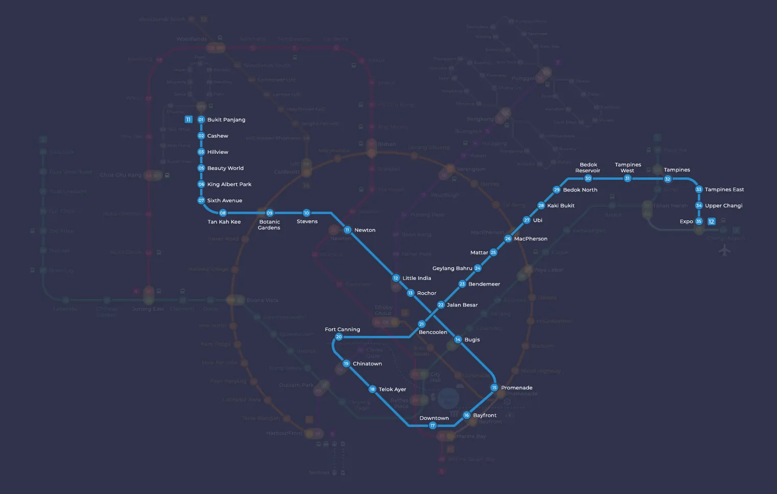
Bencoolen on the Downtown Line map
Bencoolen MRT station at a glance
| Station codes | DT21 |
|---|---|
| Lines | Downtown Line |
| Line colour | Blue line (Downtown Line) |
| Interchange | No, single line station |
| Chinese name | 明古连 |
| Tamil name | பென்கூலன் |
| Opened | 21 October 2017 (9 years ago) |
| Operator | SBS Transit |
| Station type | Underground |
| Platforms | 2 (1 island platform) |
| Address | 31 Bencoolen Street, Singapore 189658 |
| Daily ridership | About 6,536 passengers a day (2024) |
| Next stations | |
| Train times | Downtown Line: first train leaves the terminus at 5:30 AM, last train 11:40 PM Full first and last train guide |
Opening date, operator and ridership figures are LTA data as recorded on Wikipedia.
See Bencoolen on the map. The interactive map opens with this station highlighted, so you can trace the route from where you are.
Most passengers are students and staff heading to the Nanyang Academy of Fine Arts (NAFA) and Singapore Management University (SMU). The station also serves office workers at the Manulife Centre and shoppers visiting Parklane Shopping Centre and Sunshine Plaza. An SMU underpass linkway connects it with Bras Basah station on the Circle Line. This walking route does not appear on the official system maps, but it is a practical way to switch between the two lines.
History of Bencoolen MRT station
The station opened on 21 October 2017, together with the rest of the third stage of the Downtown Line, after a public open house on 15 October. During construction, part of Bencoolen Street between Prinsep Link and Bras Basah Road was closed to traffic for more than five years. When it reopened, it was a one-way street with a wide footpath, a cycle lane, a dedicated bus lane and 125 bicycle parking lots. Look out for the animal-shaped benches along the pavement, which were designed by NAFA students and alumni through a competition.
Inside Bencoolen MRT station
The station spans six underground levels and has three entrances. Exit A is inside the NAFA Tower Block, so students can reach the campus without going out in the rain. Exit B is a glass and frame structure styled to match the colonial exterior of the nearby Hotel Rendezvous, and Exit C leads underground straight into the SMU underpass. Passenger lifts serve the platforms. Their maroon-tinted glass, along with the curved walls and earth-tone colours, is meant to feel like a journey deep into the ground. The station also displays Tracing Memories, an artwork by NAFA students created for the Art-in-Transit programme.
For visitors, Bencoolen MRT station is a convenient base for the museums and shops around Bras Basah. Singapore Management University is right beside the station, and the National Museum of Singapore and the Peranakan Museum are both within a short walk. Bras Basah Complex is close by and is popular for books and stationery, while The Cathay and Bugis Plus offer more shopping and dining. Photography and film enthusiasts can also walk to the Objectifs Centre for Photography and Film.
Around Bencoolen MRT station
Bencoolen station sits in the Bras Basah and Bugis district, a cultural and educational zone home to universities, museums and shopping options. The area is well known for institutions such as Singapore Management University and the National Museum of Singapore. It is a lively mixed-use neighbourhood drawing students, tourists and shoppers alike.
| Place | Type | Distance | Why go |
|---|---|---|---|
| Singapore Management University | University | About 70 m (~1 min walk) | Visit for university campus facilities and the surrounding student atmosphere. |
| Objectifs Centre for Photography and Film | Museum | About 210 m (~3 min walk) | Visit for photography and film exhibitions in a specialist arts centre. |
| The Cathay | Shopping mall | About 300 m (~5 min walk) | Visit for cinema, dining and retail in a mid-sized city mall. |
| Singapore Management University Campus | University | About 310 m (~5 min walk) | Visit for the broader SMU campus grounds and academic facilities. |
| National Museum of Singapore | Museum | About 350 m (~6 min walk) | Visit for permanent and touring collections covering Singapore's history and culture. |
| Bugis Plus | Shopping mall | About 430 m (~7 min walk) | Visit for a range of retail shops and food outlets in a modern mall. |
| Bras Basah Complex | Shopping mall | About 440 m (~7 min walk) | Visit for second-hand books, art supplies and specialist retailers. |
| Peranakan Museum | Museum | About 540 m (~9 min walk) | Visit for exhibitions exploring Peranakan heritage and culture. |
Places and straight-line distances from OpenStreetMap data (© OpenStreetMap contributors). Actual walking routes may be longer.
How to get to Bencoolen by MRT
Worked out from the network map. Stop counts are station to station and do not include walking or waiting time.
| From Changi Airport | Take the East West Line from Changi Airport to Tampines (4 stops), then change to the Downtown Line from Tampines to Bencoolen (11 stops). About 15 stops with 1 change. |
|---|---|
| From Orchard | Take the Thomson East Coast Line from Orchard to Outram Park (3 stops), then change to the North East Line from Outram Park to Chinatown (1 stop), then change to the Downtown Line from Chinatown to Bencoolen (2 stops). About 6 stops with 2 changes. |
| From City Hall | Take the East West Line from City Hall to Bugis (1 stop), then change to the Downtown Line from Bugis to Bencoolen (7 stops). About 8 stops with 1 change. |
| From Jurong East | Take the East West Line from Jurong East to Outram Park (8 stops), then change to the North East Line from Outram Park to Chinatown (1 stop), then change to the Downtown Line from Chinatown to Bencoolen (2 stops). About 11 stops with 2 changes. |
| From Woodlands | Take the Thomson East Coast Line from Woodlands to Stevens (8 stops), then change to the Downtown Line from Stevens to Bencoolen (11 stops). About 19 stops with 1 change. |
| From HarbourFront | Take the North East Line from HarbourFront to Chinatown (2 stops), then change to the Downtown Line from Chinatown to Bencoolen (2 stops). About 4 stops with 1 change. |
Fares from Bencoolen MRT station
A trip from Bencoolen to Changi Airport (about 22 km) costs S$2.36 on an adult SimplyGo or EZ-Link card. Fares are charged by distance, so the table below shows the estimated adult card fare from Bencoolen to the main hubs, the early bird fare for journeys that start before 7.45am on weekdays, and the fare that applies from 26 December 2026.
| To | Distance | Adult card | Before 7.45am | From 26 Dec 2026 |
|---|---|---|---|---|
| Changi Airport | about 22 km, 15 stops | S$2.36 | S$1.86 | S$2.49 |
| Orchard | about 6 km, 6 stops | S$1.59 | S$1.09 | S$1.72 |
| City Hall | about 7 km, 8 stops | S$1.75 | S$1.25 | S$1.88 |
| Raffles Place | about 5 km, 5 stops | S$1.49 | S$0.99 | S$1.62 |
| Jurong East | about 17 km, 11 stops | S$2.15 | S$1.65 | S$2.28 |
| Woodlands | about 28 km, 19 stops | S$2.45 | S$1.95 | S$2.58 |
| HarbourFront | about 6 km, 4 stops | S$1.59 | S$1.09 | S$1.72 |
| Marina Bay | about 5 km, 6 stops | S$1.49 | S$0.99 | S$1.62 |
Estimated from the route distance between stations and the Public Transport Council fare table in force from 27 December 2025. The exact fare can differ by one band. Cash fares are higher. Use the fare calculator for any other journey, or check your fare on the SimplyGo app.
Tips for using Bencoolen MRT station
- Singapore Management University is the closest destination and is reachable in about a minute on foot from the station.
- The National Museum of Singapore, Peranakan Museum and Bras Basah Complex are all within walking distance, so consider grouping visits to save time.
- During morning and evening peak hours, the Downtown Line can be busy, so allow a little extra time for your journey.
- Bugis Plus and Bras Basah Complex are roughly a seven-minute walk away, making them easy to reach on foot without needing to change transport.
All stations on the Downtown Line
In order along the line, with Bencoolen marked. Stations with their own guide are linked.
| Code | Station | Interchange |
|---|---|---|
| DT1 | Bukit Panjang | DT / BP |
| DT2 | Cashew | None |
| DT3 | Hillview | None |
| DT4 | Hume | None |
| DT5 | Beauty World | None |
| DT6 | King Albert Park | None |
| DT7 | Sixth Avenue | None |
| DT8 | Tan Kah Kee | None |
| DT9 | Botanic Gardens | DT / CC |
| DT10 | Stevens | DT / TE |
| DT11 | Newton | NS / DT |
| DT12 | Little India | DT / NE |
| DT13 | Rochor | None |
| DT14 | Bugis | DT / EW |
| DT15 | Promenade | CC / DT |
| DT16 | Bayfront | CE / DT |
| DT17 | Downtown | None |
| DT18 | Telok Ayer | None |
| DT19 | Chinatown | DT / NE |
| DT20 | Fort Canning | None |
| DT21 | Bencoolen (you are here) | None |
| DT22 | Jalan Besar | None |
| DT23 | Bendemeer | None |
| DT24 | Geylang Bahru | None |
| DT25 | Mattar | None |
| DT26 | MacPherson | CC / DT |
| DT27 | Ubi | None |
| DT28 | Kaki Bukit | None |
| DT29 | Bedok North | None |
| DT30 | Bedok Reservoir | None |
| DT31 | Tampines West | None |
| DT32 | Tampines | EW / DT |
| DT33 | Tampines East | None |
| DT34 | Upper Changi | None |
| DT35 | Expo | DT / CG |
Read the full Downtown Line guide.
Bencoolen MRT station: common questions
Which line is Bencoolen MRT station on?
Bencoolen is on the Downtown Line. Its station code is DT21.
Is Bencoolen an interchange station?
No. Bencoolen is served by the Downtown Line only. The nearest interchange is shown in the next stations row above.
What time is the first and last train at Bencoolen?
Times below are for the first and last train leaving the line terminus; trains reach Bencoolen a few minutes later depending on its position on the line. Downtown Line first train 5:30 AM, last train 11:40 PM. Check the operator for holiday changes.
What is near Bencoolen MRT station?
The station is surrounded by a mix of cultural and educational landmarks, including Singapore Management University at approximately 70 metres, the National Museum of Singapore at approximately 350 metres and Bras Basah Complex at approximately 440 metres, among others.
Which shopping mall is closest to Bencoolen station?
The Cathay is the closest shopping mall at approximately 300 metres, which is roughly a five-minute walk from the station.
How far is the National Museum of Singapore from Bencoolen station?
The National Museum of Singapore is approximately 350 metres from Bencoolen station, which is roughly a six-minute walk.
How do I get to Bencoolen from Changi Airport by MRT?
Take the East West Line from Changi Airport to Tampines (4 stops), then change to the Downtown Line from Tampines to Bencoolen (11 stops). About 15 stops with 1 change.
Sources: station codes, line colours and interchanges from the LTA rail system map; operating hours from SMRT and SBS Transit. Last reviewed October 2026.
News and guides mentioning Bencoolen
- シンガポール地下鉄(MRT)路線図 2026(日本語ガイド) 4 Oct 2026
- Singapore MRT Art in Transit Programme Explained 13 Aug 2026
- Downtown Line Map 11 Aug 2023
- Tamil 11 Aug 2023
Plan the rest of the trip
Every station on the Downtown Line is listed on its line guide, with the full route and interchanges. For times, see the first and last train guide, and for the whole network in one view use the interactive Singapore MRT map or the PDF map.
Exits and buses at Bencoolen station
Bencoolen has 3 mapped exits (A to C). The letters match the signs inside the station; the landmark beside each one is the closest mapped place to that entrance, so pick the exit that comes up nearest to where you are going.
- Exit A: closest to Bencoolen Underground Mall (about 13 m from the entrance)
- Exit B: closest to Bencoolen Underground Mall (about 2 m from the entrance)
- Exit C: closest to School of Computing and Information Systems 1 (about 11 m from the entrance)
Bus stops within 250 m of Bencoolen station
| Bus stop | Stop code | Services | From station |
|---|---|---|---|
| Opposite Bencoolen Station Exit B | 04019 | 131, 131A, 147, 147A, 166, 857, 857B | 87 m |
| Before Bencoolen Station Exit A | 04029 | 64, 65, 139 | 108 m |
| Bencoolen Station Exit B | 08069 | 7, 14, 14e, 16, 16M, 36, 36B, 77, 106, 111, 124, 162, 162M, 167, 174, 174e, 175, 190, 502, 502A, 518, 518A, 652, 656, 660, 663, 665, 850E, 951E | 143 m |
| School of the Arts | 08079 | 1N, 2N, 3N, 4N, 5N, 6N, 64, 65, 131, 139, 147, 166, 857, NR6 | 150 m |
| Sunshine Plaza | 07571 | 56 | 197 m |
| Peace Centre | 07011 | 1N, 2N, 3N, 4N, 5N, 6N, 64, 65, 131, 139, 147, 166, 857, NR6 | 214 m |
Exits and bus services come from OpenStreetMap and can change when roads or routes are revised; check the board at the stop or the operator app before relying on a service late at night. For the nearest station to where you are now, use the MRT near me finder.
Places to visit from Bencoolen station
See every guide on how to get to Singapore's attractions, hospitals and malls by MRT, with routes and fares from Changi Airport, Orchard and the city.
Hungry? See food near Bencoolen MRT: hawker centres, food courts and cafes with walking times.