
Stevens MRT Station
Stevens MRT station is an underground interchange at the junction of Stevens Road and Bukit Timah Road, beside the Wayang Satu Flyover and the Bukit Timah Canal. It is served by the Downtown Line under code DT10 and the Thomson-East Coast Line under code TE11. Passengers can change between the two lines here without leaving the station area.
Stevens on the Downtown Line map
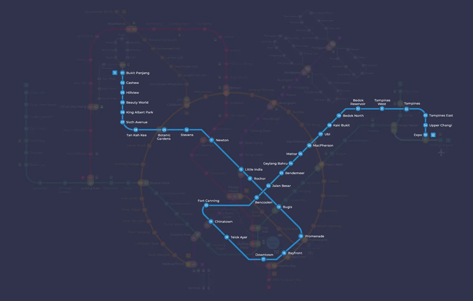
Stevens MRT station at a glance
| Station codes | DT10TE11 |
|---|---|
| Lines | Downtown Line Thomson East Coast Line |
| Line colour | Blue line (Downtown Line) Brown line (Thomson East Coast Line) |
| Interchange | Yes, change between 2 lines here |
| Chinese name | 史蒂芬 |
| Tamil name | ஸ்டீவன்ஸ் |
| Opened | 27 December 2015 (10 years ago) |
| Operator | SMRT Trains and SBS Transit |
| Station type | Underground |
| Platforms | 4 (2 stacked platforms, 1 island platform) |
| Address | 92 Stevens Road, Singapore 257877 |
| Daily ridership | About 6,799 passengers a day (2024) |
| Next stations | |
| Train times | Downtown Line: first train leaves the terminus at 5:30 AM, last train 11:40 PM Thomson East Coast Line: first train leaves the terminus at 5:36 AM, last train 11:42 PM Full first and last train guide |
Opening date, operator and ridership figures are LTA data as recorded on Wikipedia.
See Stevens on the map. The interactive map opens with this station highlighted, so you can trace the route from where you are.
The station sits among schools, private estates and a members’ club, and its passengers reflect that mix. Students and staff of Singapore Chinese Girls’ School, St. Joseph’s Institution and Chinese International School use it every school day. Residents of the surrounding private housing and visitors to the Raffles Town Club also use it, along with commuters who come here only to switch lines.
History of Stevens MRT station
The Downtown Line platforms opened on 27 December 2015 as part of the line’s second stage. The name “Stevens” was a working title that was kept after a public poll in 2009. Two extra entrances, one on Dunearn Road and one on Whitley Road, were added in November 2019. The Thomson-East Coast Line platforms were first planned for 2021 but were delayed by COVID-19 construction restrictions, and they opened on 13 November 2022.
Inside Stevens MRT station
The site is squeezed between the flyover and the canal, so the Downtown Line platforms are stacked, with each direction on its own level, and the station reaches a depth of about 34 metres. Stevens was the first station built with a separate set of fare gates for each platform, so check the signs for your direction of travel before you tap in.
The station also has two Art-in-Transit works. At the Downtown Line entrance is a long mosaic by Om Mee Ai, stamped by hand with nutmeg and rubber seed patterns that recall the plantations once grown in the area. On the Thomson-East Coast Line concourse is A Syllabus For Stevens by Shubigi Rao, a wall of bookshelves engraved with playful titles inspired by the nearby schools.
Most people use Stevens MRT station for school runs, quiet residential trips and line changes, but a few destinations are within walking distance. Malcolm Park is about five minutes away on foot, and Tanglin Community Club is around seven minutes away, which makes them handy for local residents. Families heading to Jacob Ballas Children’s Garden can reach it in roughly 13 minutes. The National University of Singapore Bukit Timah campus and the Institute of Policy Studies are also a short walk away, so the station is a practical stop for students and people attending talks and seminars.
Around Stevens MRT station
Stevens MRT station sits within a quiet, largely residential district characterised by leafy streets and low-density housing. The surrounding area blends green recreational space, with Malcolm Park nearby, and educational institutions such as the National University of Singapore's Bukit Timah campus. It is a calm, unhurried neighbourhood rather than a commercial or shopping hub.
| Place | Type | Distance | Why go |
|---|---|---|---|
| Malcolm Park | Park | About 320 m (~5 min walk) | A local park suitable for a quiet outdoor stroll or relaxation. |
| Tanglin Community Club | Community club | About 400 m (~7 min walk) | A community facility offering social and recreational programmes for residents. |
| Institute of Policy Studies | University | About 700 m (~11 min walk) | A public policy research and teaching institution within a university setting. |
| National University of Singapore (Bukit Timah) | University | About 810 m (~13 min walk) | A university campus hosting law and other faculties in a heritage setting. |
| Jacob Ballas Children's Garden | Attraction | About 830 m (~13 min walk) | A children's garden within the Botanic Gardens area, designed for family visits. |
| The Bunker | Attraction | About 880 m (~14 min walk) | A heritage attraction related to Singapore's wartime history, worth exploring. |
| Sprouts Food Place | Food centre | About 920 m (~15 min walk) | A food centre offering a variety of local cooked food options. |
| Healing Garden | Attraction | About 970 m (~16 min walk) | A therapeutic garden within the Botanic Gardens area, focused on medicinal plants. |
Places and straight-line distances from OpenStreetMap data (© OpenStreetMap contributors). Actual walking routes may be longer.
How to get to Stevens by MRT
Worked out from the network map. Stop counts are station to station and do not include walking or waiting time.
| From Changi Airport | Take the East West Line from Changi Airport to Bugis (10 stops), then change to the Downtown Line from Bugis to Stevens (4 stops). About 14 stops with 1 change. |
|---|---|
| From Orchard | Take the Thomson East Coast Line from Orchard to Stevens (3 stops). About 3 stops, no changes. |
| From City Hall | Take the North South Line from City Hall to Newton (4 stops), then change to the Downtown Line from Newton to Stevens (1 stop). About 5 stops with 1 change. |
| From Jurong East | Take the East West Line from Jurong East to Buona Vista (3 stops), then change to the Circle Line from Buona Vista to Botanic Gardens (3 stops), then change to the Downtown Line from Botanic Gardens to Stevens (1 stop). About 7 stops with 2 changes. |
| From Woodlands | Take the Thomson East Coast Line from Woodlands to Stevens (8 stops). About 8 stops, no changes. |
| From HarbourFront | Take the North East Line from HarbourFront to Little India (5 stops), then change to the Downtown Line from Little India to Stevens (2 stops). About 7 stops with 1 change. |
Fares from Stevens MRT station
A trip from Stevens to Changi Airport (about 23 km) costs S$2.36 on an adult SimplyGo or EZ-Link card. Fares are charged by distance, so the table below shows the estimated adult card fare from Stevens to the main hubs, the early bird fare for journeys that start before 7.45am on weekdays, and the fare that applies from 26 December 2026.
| To | Distance | Adult card | Before 7.45am | From 26 Dec 2026 |
|---|---|---|---|---|
| Changi Airport | about 23 km, 14 stops | S$2.36 | S$1.86 | S$2.49 |
| Orchard | about 3 km, 3 stops | S$1.38 | S$0.88 | S$1.51 |
| City Hall | about 5 km, 5 stops | S$1.59 | S$1.09 | S$1.72 |
| Raffles Place | about 7 km, 6 stops | S$1.68 | S$1.18 | S$1.81 |
| Jurong East | about 12 km, 7 stops | S$1.94 | S$1.44 | S$2.07 |
| Woodlands | about 17 km, 8 stops | S$2.20 | S$1.70 | S$2.33 |
| HarbourFront | about 9 km, 7 stops | S$1.86 | S$1.36 | S$1.99 |
| Marina Bay | about 9 km, 9 stops | S$1.82 | S$1.32 | S$1.95 |
Estimated from the route distance between stations and the Public Transport Council fare table in force from 27 December 2025. The exact fare can differ by one band. Cash fares are higher. Use the fare calculator for any other journey, or check your fare on the SimplyGo app.
Tips for using Stevens MRT station
- Stevens is an interchange station between the Downtown Line and the Thomson East Coast Line, so plan your route according to which line best suits your onward destination.
- Malcolm Park and Tanglin Community Club are the closest destinations and are manageable on foot, but most other places on this list are a 10 to 16 minute walk, so factor in extra time especially in warm weather.
- For destinations such as Jacob Ballas Children's Garden, The Bunker, the Healing Garden and Sprouts Food Place, consider taking a bus from the roads near the station rather than walking the full distance.
- During morning and evening peak hours the station can be busier due to interchange traffic, so allow a little extra time when transferring between lines or exiting the station.
All stations on the Downtown Line
In order along the line, with Stevens marked. Stations with their own guide are linked.
| Code | Station | Interchange |
|---|---|---|
| DT1 | Bukit Panjang | DT / BP |
| DT2 | Cashew | None |
| DT3 | Hillview | None |
| DT4 | Hume | None |
| DT5 | Beauty World | None |
| DT6 | King Albert Park | None |
| DT7 | Sixth Avenue | None |
| DT8 | Tan Kah Kee | None |
| DT9 | Botanic Gardens | DT / CC |
| DT10 | Stevens (you are here) | DT / TE |
| DT11 | Newton | NS / DT |
| DT12 | Little India | DT / NE |
| DT13 | Rochor | None |
| DT14 | Bugis | DT / EW |
| DT15 | Promenade | CC / DT |
| DT16 | Bayfront | CE / DT |
| DT17 | Downtown | None |
| DT18 | Telok Ayer | None |
| DT19 | Chinatown | DT / NE |
| DT20 | Fort Canning | None |
| DT21 | Bencoolen | None |
| DT22 | Jalan Besar | None |
| DT23 | Bendemeer | None |
| DT24 | Geylang Bahru | None |
| DT25 | Mattar | None |
| DT26 | MacPherson | CC / DT |
| DT27 | Ubi | None |
| DT28 | Kaki Bukit | None |
| DT29 | Bedok North | None |
| DT30 | Bedok Reservoir | None |
| DT31 | Tampines West | None |
| DT32 | Tampines | EW / DT |
| DT33 | Tampines East | None |
| DT34 | Upper Changi | None |
| DT35 | Expo | DT / CG |
Read the full Downtown Line guide.
All stations on the Thomson East Coast Line
In order along the line, with Stevens marked. Stations with their own guide are linked.
| Code | Station | Interchange |
|---|---|---|
| TE1 | Woodlands North | None |
| TE2 | Woodlands | NS / TE |
| TE3 | Woodlands South | None |
| TE4 | Springleaf | None |
| TE5 | Lentor | None |
| TE6 | Mayflower | None |
| TE7 | Bright Hill | None |
| TE8 | Upper Thomson | None |
| TE9 | Caldecott | CC / TE |
| TE11 | Stevens (you are here) | DT / TE |
| TE12 | Napier | None |
| TE13 | Orchard Boulevard | None |
| TE14 | Orchard | TE / NS |
| TE15 | Great World | None |
| TE16 | Havelock | None |
| TE17 | Outram Park | TE / EW / NE |
| TE18 | Maxwell | None |
| TE19 | Shenton Way | None |
| TE20 | Marina Bay | CE / TE / NS |
| TE22 | Gardens by the Bay | None |
| TE23 | Tanjong Rhu | None |
| TE24 | Katong Park | None |
| TE25 | Tanjong Katong | None |
| TE26 | Marine Parade | None |
| TE27 | Marine Terrace | None |
| TE28 | Siglap | None |
| TE29 | Bayshore | None |
Read the full Thomson East Coast Line guide.
Stevens MRT station: common questions
Which line is Stevens MRT station on?
Stevens is on the Downtown Line and the Thomson East Coast Line. Its station codes are DT10 and TE11.
Is Stevens an interchange station?
Yes. You can change between the Downtown Line and the Thomson East Coast Line inside the station without leaving the paid area.
What time is the first and last train at Stevens?
Times below are for the first and last train leaving the line terminus; trains reach Stevens a few minutes later depending on its position on the line. Downtown Line first train 5:30 AM, last train 11:40 PM. Thomson East Coast Line first train 5:36 AM, last train 11:42 PM. Check the operator for holiday changes.
What is near Stevens MRT station?
Nearby places include Malcolm Park at approximately 320 metres, Tanglin Community Club at approximately 400 metres, the Institute of Policy Studies and the National University of Singapore Bukit Timah campus, as well as Jacob Ballas Children's Garden and the Healing Garden, all within roughly a kilometre of the station.
Is there a food centre close to Stevens MRT station?
The nearest food centre is Sprouts Food Place, at approximately 920 metres from the station, which is roughly a 15 minute walk away.
How far is Jacob Ballas Children's Garden from Stevens MRT station?
Jacob Ballas Children's Garden is approximately 830 metres from Stevens MRT station in a straight line, which works out to roughly a 13 minute walk.
How do I get to Stevens from Changi Airport by MRT?
Take the East West Line from Changi Airport to Bugis (10 stops), then change to the Downtown Line from Bugis to Stevens (4 stops). About 14 stops with 1 change.
Sources: station codes, line colours and interchanges from the LTA rail system map; operating hours from SMRT and SBS Transit. Last reviewed October 2026.
News and guides mentioning Stevens
- Travelling with luggage on Singapore MRT: lifts, wide gates and quiet times 6 Nov 2026
- Commuter Fatigue and the North-South Corridor Delay 6 Oct 2026
- シンガポール地下鉄(MRT)路線図 2026(日本語ガイド) 4 Oct 2026
- Most Instagram-Worthy MRT Stations in Singapore 28 Sep 2026
Plan the rest of the trip
Every station on the Downtown Line and the Thomson-East Coast Line is listed on its line guide, with the full route and interchanges. For times, see the first and last train guide, and for the whole network in one view use the interactive Singapore MRT map or the PDF map.
Exits and buses at Stevens station
Stevens has 5 mapped exits (1 to 5). The numbers match the signs inside the station; the landmark beside each one is the closest mapped place to that entrance, so pick the exit that comes up nearest to where you are going.
- Exit 1
- Exit 2
- Exit 3
- Exit 4
- Exit 5
Bus stops within 250 m of Stevens station
| Bus stop | Stop code | Services | From station |
|---|---|---|---|
| Stevens Station Exit 1 | 40081 | 48, 67, 170, 960, 960e, 972M | 37 m |
| Before Stevens Station Exit 2 | 40229 | 105, 132, 190, 190A, 972, 972A | 79 m |
| Stevens Station Exit 3 | 40221 | 105, 132, 190, 972, NR2, NR3 | 111 m |
| After Stevens Station Exit 5 | 40089 | 48, 67, 170, 960, 960e, 972M | 189 m |
| Raffles Town Club | 40231 | 105, 132, 151, 153, 154, 156, 186, 190, 960, 960e, 972, 972M, NR2, NR3 | 238 m |
Exits and bus services come from OpenStreetMap and can change when roads or routes are revised; check the board at the stop or the operator app before relying on a service late at night. For the nearest station to where you are now, use the MRT near me finder.
Places to visit from Stevens station
See every guide on how to get to Singapore's attractions, hospitals and malls by MRT, with routes and fares from Changi Airport, Orchard and the city.