
Fort Canning MRT Station
Fort Canning MRT station is a station on the Downtown Line, carrying the station code DT20. It is not an interchange station. The station sits in the heart of central Singapore, serving a mixed area that includes cultural attractions, parkland, and the fringes of the civic and arts district. It provides convenient underground access to this part of the city for residents, visitors, and workers travelling into the centre.
Fort Canning on the Downtown Line map
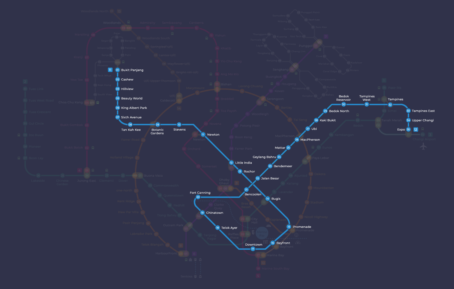
Fort Canning MRT station at a glance
| Station codes | DT20 |
|---|---|
| Lines | Downtown Line |
| Line colour | Blue line (Downtown Line) |
| Interchange | No, single line station |
| Chinese name | 福康宁 |
| Tamil name | ஃபோர்ட் கெனிங் |
| Next stations | |
| Train times | Downtown Line: first train leaves the terminus at 5:30 AM, last train 11:40 PM Full first and last train guide |
See Fort Canning on the map. The interactive map opens with this station highlighted, so you can trace the route from where you are.
From Fort Canning, the Downtown Line connects directly to neighbouring stations at Chinatown and Bencoolen. At Chinatown station, passengers can transfer to the North East Line, making onward journeys to destinations such as Dhoby Ghaut, Outram Park, or HarbourFront straightforward. At Bencoolen, there is no interchange, but the line continues deeper into the city. The Downtown Line itself runs across a broad stretch of Singapore, giving Fort Canning passengers direct access to many central and eastern destinations without changing trains.
Fort Canning Park is the most prominent landmark within easy walking distance of the station. This large green hill in the centre of Singapore contains open lawns, historical earthworks, and outdoor performance spaces, and it draws visitors year-round. The surrounding streets also bring walkers close to the Singapore River area and the arts and cultural precinct that extends along Hill Street and the nearby civic district, making this station a practical starting point for exploring that part of central Singapore on foot.
Around Fort Canning MRT station
Fort Canning station sits in the heart of Singapore's civic and cultural district, surrounded by heritage institutions, green hillside parkland and leisure destinations. The area is popular with tourists and locals alike, with attractions such as the Peranakan Museum and the Fort Canning Tree Tunnel drawing regular visitors. Shopping options including Clarke Quay Central and Funan are also within walking distance, making this a well-rounded urban neighbourhood.
| Place | Type | Distance | Why go |
|---|---|---|---|
| Sri Thendayuthapani Temple | Place of worship | About 160 m (~3 min walk) | Visit to worship or to admire a traditional South Indian Hindu temple. |
| Battlebox Visitor Centre | Museum | About 460 m (~7 min walk) | Explore preserved wartime tunnels and learn about Singapore's World War II history. |
| Clarke Quay Central | Shopping mall | About 460 m (~7 min walk) | Browse shops, grab a meal or catch a film at this riverside mall. |
| Peranakan Museum | Museum | About 560 m (~9 min walk) | Discover Peranakan culture, art and heritage through engaging permanent and visiting exhibitions. |
| Fort Canning Tree Tunnel | Attraction | About 580 m (~9 min walk) | Walk through a striking natural tunnel formed by a canopy of trees within Fort Canning Park. |
| National Museum of Singapore | Museum | About 640 m (~10 min walk) | Spend time exploring Singapore's history and natural heritage at this landmark national institution. |
| Funan | Shopping mall | About 640 m (~10 min walk) | Visit for shopping, dining and a mix of lifestyle and technology-focused retail. |
| The Cathay | Shopping mall | About 870 m (~14 min walk) | Head here for shopping, dining and cinema options in the Dhoby Ghaut area. |
Places and straight-line distances from OpenStreetMap data (© OpenStreetMap contributors). Actual walking routes may be longer.
How to get to Fort Canning by MRT
Worked out from the network map. Stop counts are station to station and do not include walking or waiting time.
| From Changi Airport | Take the East West Line from Changi Airport to Paya Lebar (6 stops), then change to the Circle Line from Paya Lebar to MacPherson (1 stop), then change to the Downtown Line from MacPherson to Fort Canning (6 stops). About 13 stops with 2 changes. |
|---|---|
| From Orchard | Take the Thomson East Coast Line from Orchard to Outram Park (3 stops), then change to the North East Line from Outram Park to Chinatown (1 stop), then change to the Downtown Line from Chinatown to Fort Canning (1 stop). About 5 stops with 2 changes. |
| From City Hall | Take the North South Line from City Hall to Dhoby Ghaut (1 stop), then change to the North East Line from Dhoby Ghaut to Chinatown (2 stops), then change to the Downtown Line from Chinatown to Fort Canning (1 stop). About 4 stops with 2 changes. |
| From Jurong East | Take the East West Line from Jurong East to Outram Park (8 stops), then change to the North East Line from Outram Park to Chinatown (1 stop), then change to the Downtown Line from Chinatown to Fort Canning (1 stop). About 10 stops with 2 changes. |
| From Woodlands | Take the Thomson East Coast Line from Woodlands to Stevens (8 stops), then change to the Downtown Line from Stevens to Fort Canning (10 stops). About 18 stops with 1 change. |
| From HarbourFront | Take the North East Line from HarbourFront to Chinatown (2 stops), then change to the Downtown Line from Chinatown to Fort Canning (1 stop). About 3 stops with 1 change. |
Fares from Fort Canning MRT station
A trip from Fort Canning to Changi Airport (about 24 km) costs S$2.38 on an adult SimplyGo or EZ-Link card. Fares are charged by distance, so the table below shows the estimated adult card fare from Fort Canning to the main hubs, the early bird fare for journeys that start before 7.45am on weekdays, and the fare that applies from 26 December 2026.
| To | Distance | Adult card | Before 7.45am | From 26 Dec 2026 |
|---|---|---|---|---|
| Changi Airport | about 24 km, 16 stops | S$2.38 | S$1.88 | S$2.51 |
| Orchard | about 5 km, 5 stops | S$1.49 | S$0.99 | S$1.62 |
| City Hall | about 4 km, 4 stops | S$1.38 | S$0.88 | S$1.51 |
| Raffles Place | about 4 km, 4 stops | S$1.38 | S$0.88 | S$1.51 |
| Jurong East | about 16 km, 10 stops | S$2.11 | S$1.61 | S$2.24 |
| Woodlands | about 27 km, 18 stops | S$2.44 | S$1.94 | S$2.57 |
| HarbourFront | about 5 km, 3 stops | S$1.49 | S$0.99 | S$1.62 |
| Marina Bay | about 4 km, 5 stops | S$1.38 | S$0.88 | S$1.51 |
Estimated from the route distance between stations and the Public Transport Council fare table in force from 27 December 2025. The exact fare can differ by one band. Cash fares are higher. Use the fare calculator for any other journey, or check your fare on the SimplyGo app.
Tips for using Fort Canning MRT station
- The Fort Canning Tree Tunnel and Battlebox Visitor Centre are both within the Fort Canning Park area, so consider combining them into a single visit to make the most of your trip.
- Clarke Quay Central is approximately a seven-minute walk away, but the route involves some incline near the park, so allow a little extra time if you are unfamiliar with the area.
- The National Museum of Singapore and Funan are around a ten-minute walk from the station, making them easy on foot if you are not pressed for time, though travelling one stop on the Downtown Line is an option for reaching Funan more quickly.
- The station serves only the Downtown Line, so if you need to transfer to other lines, plan to travel to a nearby interchange station such as Bugis or Promenade.
All stations on the Downtown Line
In order along the line, with Fort Canning marked. Stations with their own guide are linked.
| Code | Station | Interchange |
|---|---|---|
| DT1 | Bukit Panjang | DT / BP |
| DT2 | Cashew | None |
| DT3 | Hillview | None |
| DT4 | Hume | None |
| DT5 | Beauty World | None |
| DT6 | King Albert Park | None |
| DT7 | Sixth Avenue | None |
| DT8 | Tan Kah Kee | None |
| DT9 | Botanic Gardens | DT / CC |
| DT10 | Stevens | DT / TE |
| DT11 | Newton | NS / DT |
| DT12 | Little India | DT / NE |
| DT13 | Rochor | None |
| DT14 | Bugis | DT / EW |
| DT15 | Promenade | CC / DT |
| DT16 | Bayfront | CE / DT |
| DT17 | Downtown | None |
| DT18 | Telok Ayer | None |
| DT19 | Chinatown | DT / NE |
| DT20 | Fort Canning (you are here) | None |
| DT21 | Bencoolen | None |
| DT22 | Jalan Besar | None |
| DT23 | Bendemeer | None |
| DT24 | Geylang Bahru | None |
| DT25 | Mattar | None |
| DT26 | MacPherson | CC / DT |
| DT27 | Ubi | None |
| DT28 | Kaki Bukit | None |
| DT29 | Bedok North | None |
| DT30 | Bedok Reservoir | None |
| DT31 | Tampines West | None |
| DT32 | Tampines | EW / DT |
| DT33 | Tampines East | None |
| DT34 | Upper Changi | None |
| DT35 | Expo | DT / CG |
Read the full Downtown Line guide.
Fort Canning MRT station: common questions
Which line is Fort Canning MRT station on?
Fort Canning is on the Downtown Line. Its station code is DT20.
Is Fort Canning an interchange station?
No. Fort Canning is served by the Downtown Line only. The nearest interchange is shown in the next stations row above.
What time is the first and last train at Fort Canning?
Times below are for the first and last train leaving the line terminus; trains reach Fort Canning a few minutes later depending on its position on the line. Downtown Line first train 5:30 AM, last train 11:40 PM. Check the operator for holiday changes.
What is near Fort Canning MRT station?
The station is close to several cultural and leisure destinations, including Sri Thendayuthapani Temple at approximately 160 metres, the Battlebox Visitor Centre and Clarke Quay Central at around 460 metres, and the Peranakan Museum and Fort Canning Tree Tunnel at roughly 560 to 580 metres.
Which shopping mall is closest to Fort Canning station?
Clarke Quay Central is the closest shopping mall, at approximately 460 metres straight-line distance, which is roughly a seven-minute walk.
How far is the National Museum of Singapore from Fort Canning station?
The National Museum of Singapore is approximately 640 metres away in a straight line, which works out to roughly a ten-minute walk.
How do I get to Fort Canning from Changi Airport by MRT?
Take the East West Line from Changi Airport to Paya Lebar (6 stops), then change to the Circle Line from Paya Lebar to MacPherson (1 stop), then change to the Downtown Line from MacPherson to Fort Canning (6 stops). About 13 stops with 2 changes.
Sources: station codes, line colours and interchanges from the LTA rail system map; operating hours from SMRT and SBS Transit. Last reviewed September 2026.
News and guides mentioning Fort Canning
- MRT Map (2017) 11 Aug 2023
- Downtown Line Map 11 Aug 2023
Plan the rest of the trip
Every station on the Downtown Line is listed on its line guide, with the full route and interchanges. For times, see the first and last train guide, and for the whole network in one view use the interactive Singapore MRT map or the PDF map.