
Bayfront MRT Station
Bayfront MRT station lies beneath Bayfront Avenue in the Downtown Core, close to the waterfront at Marina Bay. It is an underground interchange served by two lines: the Downtown Line, where it carries the code DT16, and the Circle Line’s Marina Bay extension, where it is numbered CE1.
Bayfront on the Circle Line (Marina Bay extension) map
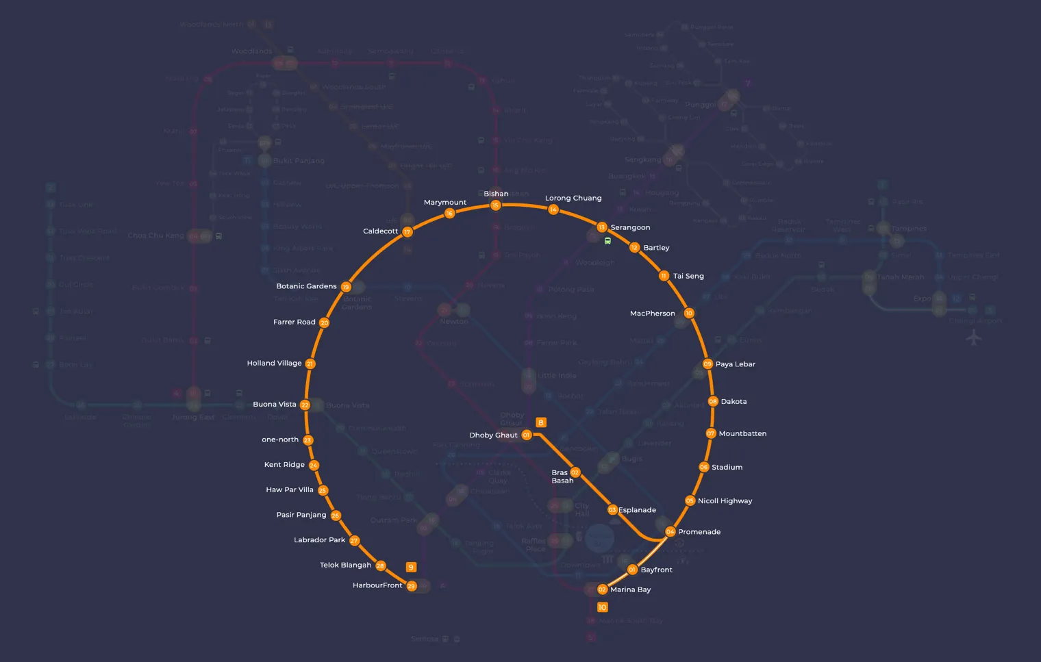
Bayfront MRT station at a glance
| Station codes | CE1DT16 |
|---|---|
| Lines | Circle Line (Marina Bay extension) Downtown Line |
| Line colour | Yellow line (Circle Line (Marina Bay extension)) Blue line (Downtown Line) |
| Interchange | Yes, change between 2 lines here |
| Chinese name | 海湾舫 |
| Tamil name | பேஃபிரண்ட் |
| Opened | 14 January 2012 (14 years ago) |
| Operator | SMRT Trains and SBS Transit |
| Station type | Underground |
| Platforms | 4 (2 island platforms) |
| Address | 11 Bayfront Avenue, Singapore 018957 |
| Daily ridership | About 38,076 passengers a day (2024) |
| Next stations | |
| Train times | Circle Line (Marina Bay extension): first train leaves the terminus at 5:37 AM, last train 11:56 PM Downtown Line: first train leaves the terminus at 5:30 AM, last train 11:40 PM Full first and last train guide |
Opening date, operator and ridership figures are LTA data as recorded on Wikipedia.
See Bayfront on the map. The interactive map opens with this station highlighted, so you can trace the route from where you are.
Most passengers who use the station are heading to Marina Bay Sands or Gardens by the Bay, two of Singapore’s best known attractions. It also serves shoppers, museum visitors and people working or staying in the hotels and offices around the bay, so platforms can be busy at weekends and during evening events.
History of Bayfront MRT station
Circle Line trains began calling here on 14 January 2012, and the Downtown Line platforms followed on 22 December 2013. Because the station was built to serve the Marina Bay Sands resort, the developer of that resort designed its northern end so that the two would fit together. The first Chinese name proposed for the station was criticised as a meaningless sound translation, so it was replaced with one combining the characters for “bay” and “small boats” to suit the maritime setting.
Inside Bayfront MRT station
The station has two island platforms arranged as a cross-platform interchange, so changing between the Circle Line and the Downtown Line often means simply walking across the platform rather than using stairs or escalators. There are five entrances. Along the concourse you will find When the Ship Comes In by Lee Wen, an Art-in-Transit work made from ship designs drawn by Singaporean children aged 7 to 12, printed on vitreous enamel panels as a tribute to Singapore’s history as a port.
For most visitors, Bayfront MRT station is the most convenient stop for a day around Marina Bay. The Shoppes at Marina Bay Sands is roughly 180 m away, about a three minute walk, and the ArtScience Museum is around 390 m from the station. The Red Dot Design Museum is roughly an eight minute walk, while The Helix Bridge, about 550 m away, gives a pleasant route on foot across the water. Those happy to walk a little further can reach the Asian Civilisations Museum in around 17 minutes.
Around Bayfront MRT station
Bayfront station sits at the heart of the Marina Bay entertainment and leisure precinct, surrounded by major attractions including The Shoppes at Marina Bay Sands and the ArtScience Museum. The area is dominated by large-scale hospitality, retail, and cultural venues rather than residential or industrial uses. The waterfront setting also brings visitors to attractions such as The Helix Bridge and Colonial Garden along the bay.
| Place | Type | Distance | Why go |
|---|---|---|---|
| The Shoppes at Marina Bay Sands | Shopping mall | About 180 m (~3 min walk) | Visit for shopping, dining, and entertainment at a large integrated resort mall. |
| IMBA Theatre | Gallery | About 260 m (~4 min walk) | Visit to experience an immersive theatre and gallery attraction. |
| Spectra | Attraction | About 280 m (~5 min walk) | Visit for a recurring light and water display at the bay. |
| Colonial Garden | Attraction | About 380 m (~6 min walk) | Visit to enjoy a landscaped waterfront garden along the bay promenade. |
| ArtScience Museum | Museum | About 390 m (~6 min walk) | Visit to explore interactive exhibitions on art, science, and technology. |
| Red Dot Design Museum | Museum | About 470 m (~8 min walk) | Visit to view award-winning design objects and design-focused exhibitions. |
| The Helix Bridge | Attraction | About 550 m (~9 min walk) | Visit to walk across a distinctive double-helix pedestrian bridge over the bay. |
| Asian Civilisations Museum | Museum | About 1060 m (~17 min walk) | Visit to learn about the history and cultures of Asia through museum collections. |
Places and straight-line distances from OpenStreetMap data (© OpenStreetMap contributors). Actual walking routes may be longer.
How to get to Bayfront by MRT
Worked out from the network map. Stop counts are station to station and do not include walking or waiting time.
| From Changi Airport | Take the East West Line from Changi Airport to Bugis (10 stops), then change to the Downtown Line from Bugis to Bayfront (2 stops). About 12 stops with 1 change. |
|---|---|
| From Orchard | Take the North South Line from Orchard to Marina Bay (5 stops), then change to the Circle Line from Marina Bay to Bayfront (1 stop). About 6 stops with 1 change. |
| From City Hall | Take the North South Line from City Hall to Marina Bay (2 stops), then change to the Circle Line from Marina Bay to Bayfront (1 stop). About 3 stops with 1 change. |
| From Jurong East | Take the East West Line from Jurong East to Bugis (12 stops), then change to the Downtown Line from Bugis to Bayfront (2 stops). About 14 stops with 1 change. |
| From Woodlands | Take the Thomson East Coast Line from Woodlands to Stevens (8 stops), then change to the Downtown Line from Stevens to Bayfront (6 stops). About 14 stops with 1 change. |
| From HarbourFront | Take the Circle Line from HarbourFront to Bayfront (5 stops). About 5 stops, no changes. |
Fares from Bayfront MRT station
A trip from Bayfront to Changi Airport (about 20 km) costs S$2.30 on an adult SimplyGo or EZ-Link card. Fares are charged by distance, so the table below shows the estimated adult card fare from Bayfront to the main hubs, the early bird fare for journeys that start before 7.45am on weekdays, and the fare that applies from 26 December 2026.
| To | Distance | Adult card | Before 7.45am | From 26 Dec 2026 |
|---|---|---|---|---|
| Changi Airport | about 20 km, 12 stops | S$2.30 | S$1.80 | S$2.43 |
| Orchard | about 7 km, 6 stops | S$1.68 | S$1.18 | S$1.81 |
| City Hall | about 3 km, 3 stops | S$1.38 | S$0.88 | S$1.51 |
| Raffles Place | about 2 km, 2 stops | S$1.28 | S$0.78 | S$1.40 |
| Jurong East | about 20 km, 14 stops | S$2.27 | S$1.77 | S$2.40 |
| Woodlands | about 24 km, 14 stops | S$2.40 | S$1.90 | S$2.53 |
| HarbourFront | about 5 km, 5 stops | S$1.59 | S$1.09 | S$1.72 |
| Marina Bay | about 1 km, 1 stop | S$1.28 | S$0.78 | S$1.40 |
Estimated from the route distance between stations and the Public Transport Council fare table in force from 27 December 2025. The exact fare can differ by one band. Cash fares are higher. Use the fare calculator for any other journey, or check your fare on the SimplyGo app.
Tips for using Bayfront MRT station
- The Shoppes at Marina Bay Sands is the closest major destination and is reachable on foot in roughly three minutes from the station.
- Bayfront is an interchange station served by both the Circle Line and the Downtown Line, so plan your route according to which line best connects to your onward destination.
- For the Asian Civilisations Museum, the walking distance of approximately 17 minutes is considerable, so consider travelling one stop on a connecting line to a closer station if you prefer a shorter walk.
- The area draws large crowds during events and public holidays, so allow extra time to navigate the station and surrounding pedestrian paths during peak periods.
All stations on the Downtown Line
In order along the line, with Bayfront marked. Stations with their own guide are linked.
| Code | Station | Interchange |
|---|---|---|
| DT1 | Bukit Panjang | DT / BP |
| DT2 | Cashew | None |
| DT3 | Hillview | None |
| DT4 | Hume | None |
| DT5 | Beauty World | None |
| DT6 | King Albert Park | None |
| DT7 | Sixth Avenue | None |
| DT8 | Tan Kah Kee | None |
| DT9 | Botanic Gardens | DT / CC |
| DT10 | Stevens | DT / TE |
| DT11 | Newton | NS / DT |
| DT12 | Little India | DT / NE |
| DT13 | Rochor | None |
| DT14 | Bugis | DT / EW |
| DT15 | Promenade | CC / DT |
| DT16 | Bayfront (you are here) | CE / DT |
| DT17 | Downtown | None |
| DT18 | Telok Ayer | None |
| DT19 | Chinatown | DT / NE |
| DT20 | Fort Canning | None |
| DT21 | Bencoolen | None |
| DT22 | Jalan Besar | None |
| DT23 | Bendemeer | None |
| DT24 | Geylang Bahru | None |
| DT25 | Mattar | None |
| DT26 | MacPherson | CC / DT |
| DT27 | Ubi | None |
| DT28 | Kaki Bukit | None |
| DT29 | Bedok North | None |
| DT30 | Bedok Reservoir | None |
| DT31 | Tampines West | None |
| DT32 | Tampines | EW / DT |
| DT33 | Tampines East | None |
| DT34 | Upper Changi | None |
| DT35 | Expo | DT / CG |
Read the full Downtown Line guide.
Bayfront MRT station: common questions
Which line is Bayfront MRT station on?
Bayfront is on the Circle Line (Marina Bay extension) and the Downtown Line. Its station codes are CE1 and DT16.
Is Bayfront an interchange station?
Yes. You can change between the Circle Line (Marina Bay extension) and the Downtown Line inside the station without leaving the paid area.
What time is the first and last train at Bayfront?
Times below are for the first and last train leaving the line terminus; trains reach Bayfront a few minutes later depending on its position on the line. Circle Line (Marina Bay extension) first train 5:37 AM, last train 11:56 PM. Downtown Line first train 5:30 AM, last train 11:40 PM. Check the operator for holiday changes.
What is near Bayfront MRT station?
Bayfront station is close to several attractions and venues including The Shoppes at Marina Bay Sands, the ArtScience Museum, the IMBA Theatre, Colonial Garden, the Red Dot Design Museum, and The Helix Bridge, all within roughly a ten-minute walk or less.
Which mall is closest to Bayfront MRT station?
The Shoppes at Marina Bay Sands is the closest shopping mall, at approximately 180 metres from the station, which is roughly a three-minute walk.
How far is the ArtScience Museum from Bayfront MRT station?
The ArtScience Museum is approximately 390 metres from Bayfront station, which is roughly a six-minute walk.
How do I get to Bayfront from Changi Airport by MRT?
Take the East West Line from Changi Airport to Bugis (10 stops), then change to the Downtown Line from Bugis to Bayfront (2 stops). About 12 stops with 1 change.
Sources: station codes, line colours and interchanges from the LTA rail system map; operating hours from SMRT and SBS Transit. Last reviewed October 2026.
News and guides mentioning Bayfront
- Sketching on the MRT: What If Someone Draws Your Child? 6 Nov 2026
- Getting to Sentosa by public transport: MRT, cable car and monorail 6 Nov 2026
- MRT shopping malls: Direct station connections in Singapore 6 Nov 2026
- Singapore MRT line colours: every line by colour 6 Oct 2026
Plan the rest of the trip
Every station on the Circle Line (Marina Bay extension) and the Downtown Line is listed on its line guide, with the full route and interchanges. For times, see the first and last train guide, and for the whole network in one view use the interactive Singapore MRT map or the PDF map.
Exits and buses at Bayfront station
Bayfront has 5 mapped exits (A to E). The letters match the signs inside the station; the landmark beside each one is the closest mapped place to that entrance, so pick the exit that comes up nearest to where you are going.
- Exit A
- Exit B
- Exit C
- Exit D
- Exit E
Bus stops within 250 m of Bayfront station
| Bus stop | Stop code | Services | From station |
|---|---|---|---|
| Bayfront Station Exit B/MBS | 03509 | 97, 97e, 106, 133, 502, 502A, 518, 518A | 78 m |
| After Bayfront Station Exit E | 03511 | 97, 97e, 106, 133, NR1, NR6 | 99 m |
| Bayfront Station Exit A | 03519 | 97, 97e, 106, 133, 502, 502A, 518, 518A | 176 m |
Exits and bus services come from OpenStreetMap and can change when roads or routes are revised; check the board at the stop or the operator app before relying on a service late at night. For the nearest station to where you are now, use the MRT near me finder.
Places to visit from Bayfront station
Step-by-step guides with the exit to use, the walk and the fare:
See every guide on how to get to Singapore's attractions, hospitals and malls by MRT, with routes and fares from Changi Airport, Orchard and the city.
MRT routes from Bayfront
Step-by-step directions with stops, changes, fare and time: Bayfront to Bishan | Bayfront to Bugis | Bayfront to Chinatown | Bayfront to Jurong East | Bayfront to Punggol | Bayfront to Tampines | Bayfront to Woodlands.
Routes to Bayfront: Changi Airport to Bayfront | City Hall to Bayfront | Orchard to Bayfront | Raffles Place to Bayfront.
More on the MRT routes hub.