
Sixth Avenue MRT Station
Sixth Avenue is a station on the Downtown Line, carrying the station code DT7. It sits in a quiet, established residential area in the Bukit Timah corridor, serving the landed housing estates and private condominiums that make up much of this part of western Singapore. The station provides residents in the area with a direct rail link into the city centre and across to the eastern end of the Downtown Line.
Sixth Avenue on the Downtown Line map
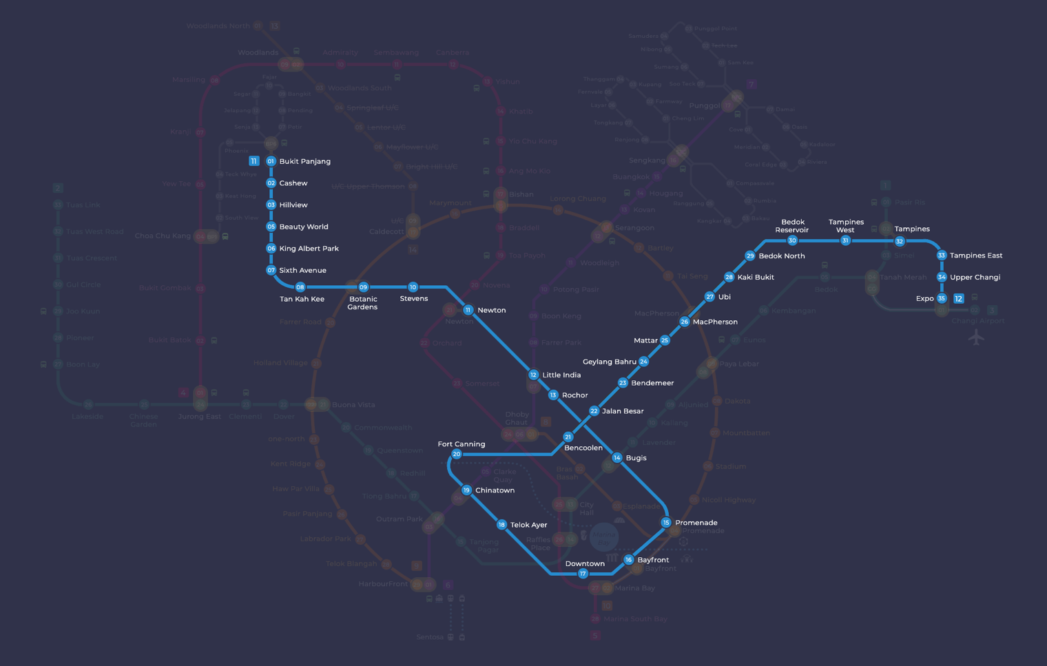
Sixth Avenue MRT station at a glance
| Station codes | DT7 |
|---|---|
| Lines | Downtown Line |
| Line colour | Blue line (Downtown Line) |
| Interchange | No, single line station |
| Chinese name | 第六道 |
| Tamil name | சிக்ஸ்த் அவென்யூ |
| Next stations | |
| Train times | Downtown Line: first train leaves the terminus at 5:30 AM, last train 11:40 PM Full first and last train guide |
See Sixth Avenue on the map. The interactive map opens with this station highlighted, so you can trace the route from where you are.
Sixth Avenue is not an interchange station, so passengers needing to switch lines will have to travel to a connecting station elsewhere on the network. On the Downtown Line, the two neighbouring stations are King Albert Park (DT6) towards Bukit Panjang and Tan Kah Kee (DT8) towards the city. From Tan Kah Kee, passengers can continue directly towards Botanic Gardens, where the Downtown Line meets the Circle Line, giving onward access across the rest of the network.
The station serves a predominantly low-rise residential neighbourhood of bungalows, semi-detached houses and small apartment blocks typical of the Bukit Timah area. The surrounding streets have a handful of neighbourhood shops and small eateries catering mainly to local residents. Bukit Timah Road runs nearby, connecting the area to other parts of the island, and the general character of the neighbourhood is calm and green, with mature trees lining many of the surrounding roads.
Around Sixth Avenue MRT station
Sixth Avenue MRT station sits within a quiet, well-established residential neighbourhood in the Bukit Timah area, characterised by low-rise housing and tree-lined streets. The surroundings are home to several well-known educational institutions, including Hwa Chong Institution and Hwa Chong International School. Small parks such as Maple Lane Park add a touch of greenery to the largely suburban environment.
| Place | Type | Distance | Why go |
|---|---|---|---|
| Maple Lane Park | Park | About 520 m (~8 min walk) | Visit Maple Lane Park for a quiet green space and a leisurely stroll. |
| Hwa Chong International School | College | About 620 m (~10 min walk) | Hwa Chong International School is an established international school serving secondary and pre-university students. |
| SIM University | College | About 640 m (~10 min walk) | SIM University is a higher education institution offering a range of undergraduate and postgraduate programmes. |
| Namly Park | Park | About 870 m (~14 min walk) | Namly Park offers a relaxed outdoor setting suitable for walking and unwinding. |
| Hwa Chong Institution | College | About 880 m (~14 min walk) | Hwa Chong Institution is a well-known school providing secondary and junior college education. |
| Coronation Park | Park | About 1020 m (~17 min walk) | Coronation Park is a neighbourhood park suitable for a gentle walk or some outdoor leisure time. |
Places and straight-line distances from OpenStreetMap data (© OpenStreetMap contributors). Actual walking routes may be longer.
How to get to Sixth Avenue by MRT
Worked out from the network map. Stop counts are station to station and do not include walking or waiting time.
| From Changi Airport | Take the East West Line from Changi Airport to Bugis (10 stops), then change to the Downtown Line from Bugis to Sixth Avenue (7 stops). About 17 stops with 1 change. |
|---|---|
| From Orchard | Take the North South Line from Orchard to Newton (1 stop), then change to the Downtown Line from Newton to Sixth Avenue (4 stops). About 5 stops with 1 change. |
| From City Hall | Take the North South Line from City Hall to Newton (4 stops), then change to the Downtown Line from Newton to Sixth Avenue (4 stops). About 8 stops with 1 change. |
| From Jurong East | Take the East West Line from Jurong East to Buona Vista (3 stops), then change to the Circle Line from Buona Vista to Botanic Gardens (3 stops), then change to the Downtown Line from Botanic Gardens to Sixth Avenue (2 stops). About 8 stops with 2 changes. |
| From Woodlands | Take the Thomson East Coast Line from Woodlands to Stevens (8 stops), then change to the Downtown Line from Stevens to Sixth Avenue (3 stops). About 11 stops with 1 change. |
| From HarbourFront | Take the North East Line from HarbourFront to Little India (5 stops), then change to the Downtown Line from Little India to Sixth Avenue (5 stops). About 10 stops with 1 change. |
Fares from Sixth Avenue MRT station
A trip from Sixth Avenue to Changi Airport (about 26 km) costs S$2.43 on an adult SimplyGo or EZ-Link card. Fares are charged by distance, so the table below shows the estimated adult card fare from Sixth Avenue to the main hubs, the early bird fare for journeys that start before 7.45am on weekdays, and the fare that applies from 26 December 2026.
| To | Distance | Adult card | Before 7.45am | From 26 Dec 2026 |
|---|---|---|---|---|
| Changi Airport | about 26 km, 17 stops | S$2.43 | S$1.93 | S$2.56 |
| Orchard | about 7 km, 5 stops | S$1.68 | S$1.18 | S$1.81 |
| City Hall | about 9 km, 8 stops | S$1.86 | S$1.36 | S$1.99 |
| Raffles Place | about 10 km, 9 stops | S$1.90 | S$1.40 | S$2.03 |
| Jurong East | about 13 km, 8 stops | S$1.98 | S$1.48 | S$2.11 |
| Woodlands | about 21 km, 11 stops | S$2.33 | S$1.83 | S$2.46 |
| HarbourFront | about 14 km, 10 stops | S$2.02 | S$1.52 | S$2.15 |
| Marina Bay | about 12 km, 10 stops | S$1.94 | S$1.44 | S$2.07 |
Estimated from the route distance between stations and the Public Transport Council fare table in force from 27 December 2025. The exact fare can differ by one band. Cash fares are higher. Use the fare calculator for any other journey, or check your fare on the SimplyGo app.
Tips for using Sixth Avenue MRT station
- Maple Lane Park and both Hwa Chong campuses are reachable within roughly 10 to 14 minutes on foot, making them manageable destinations for most visitors.
- Namly Park and Coronation Park are over 800 metres away, so allow extra time or consider a short bus ride if you prefer not to walk.
- The Downtown Line runs frequently, but services can be busier during morning and evening peak hours, so allow a little extra travel time on weekdays.
- Sixth Avenue is a non-interchange station, so plan your journey in advance if you need to connect to other MRT lines, as you will need to travel to a nearby interchange station.
All stations on the Downtown Line
In order along the line, with Sixth Avenue marked. Stations with their own guide are linked.
| Code | Station | Interchange |
|---|---|---|
| DT1 | Bukit Panjang | DT / BP |
| DT2 | Cashew | None |
| DT3 | Hillview | None |
| DT4 | Hume | None |
| DT5 | Beauty World | None |
| DT6 | King Albert Park | None |
| DT7 | Sixth Avenue (you are here) | None |
| DT8 | Tan Kah Kee | None |
| DT9 | Botanic Gardens | DT / CC |
| DT10 | Stevens | DT / TE |
| DT11 | Newton | NS / DT |
| DT12 | Little India | DT / NE |
| DT13 | Rochor | None |
| DT14 | Bugis | DT / EW |
| DT15 | Promenade | CC / DT |
| DT16 | Bayfront | CE / DT |
| DT17 | Downtown | None |
| DT18 | Telok Ayer | None |
| DT19 | Chinatown | DT / NE |
| DT20 | Fort Canning | None |
| DT21 | Bencoolen | None |
| DT22 | Jalan Besar | None |
| DT23 | Bendemeer | None |
| DT24 | Geylang Bahru | None |
| DT25 | Mattar | None |
| DT26 | MacPherson | CC / DT |
| DT27 | Ubi | None |
| DT28 | Kaki Bukit | None |
| DT29 | Bedok North | None |
| DT30 | Bedok Reservoir | None |
| DT31 | Tampines West | None |
| DT32 | Tampines | EW / DT |
| DT33 | Tampines East | None |
| DT34 | Upper Changi | None |
| DT35 | Expo | DT / CG |
Read the full Downtown Line guide.
Sixth Avenue MRT station: common questions
Which line is Sixth Avenue MRT station on?
Sixth Avenue is on the Downtown Line. Its station code is DT7.
Is Sixth Avenue an interchange station?
No. Sixth Avenue is served by the Downtown Line only. The nearest interchange is shown in the next stations row above.
What time is the first and last train at Sixth Avenue?
Times below are for the first and last train leaving the line terminus; trains reach Sixth Avenue a few minutes later depending on its position on the line. Downtown Line first train 5:30 AM, last train 11:40 PM. Check the operator for holiday changes.
What is near Sixth Avenue MRT station?
The station is surrounded by residential streets and is within walking distance of several educational institutions, including Hwa Chong International School and SIM University, as well as green spaces such as Maple Lane Park and Namly Park.
Is there a park close to Sixth Avenue MRT station?
Yes, Maple Lane Park is the closest park at approximately 520 metres away, roughly an 8-minute walk, while Namly Park and Coronation Park are also reachable on foot though they are further away.
How far is Hwa Chong Institution from Sixth Avenue MRT station?
Hwa Chong Institution is approximately 880 metres from the station, which is roughly a 14-minute walk; please note that all distances are approximate.
How do I get to Sixth Avenue from Changi Airport by MRT?
Take the East West Line from Changi Airport to Bugis (10 stops), then change to the Downtown Line from Bugis to Sixth Avenue (7 stops). About 17 stops with 1 change.
Sources: station codes, line colours and interchanges from the LTA rail system map; operating hours from SMRT and SBS Transit. Last reviewed September 2026.
Plan the rest of the trip
Every station on the Downtown Line is listed on its line guide, with the full route and interchanges. For times, see the first and last train guide, and for the whole network in one view use the interactive Singapore MRT map or the PDF map.