
Bukit Panjang MRT Station
Bukit Panjang MRT station sits at the junction of Upper Bukit Timah Road and Petir Road, in the centre of the Bukit Panjang estate. It is an interchange with the code DT1 on the Downtown Line and BP6 on the Bukit Panjang LRT. It is currently the Downtown Line’s terminus. The station forms part of the Bukit Panjang Integrated Transport Hub, which also includes a bus interchange, so trains, light rail and buses all meet at one spot.
Bukit Panjang on the Downtown Line map
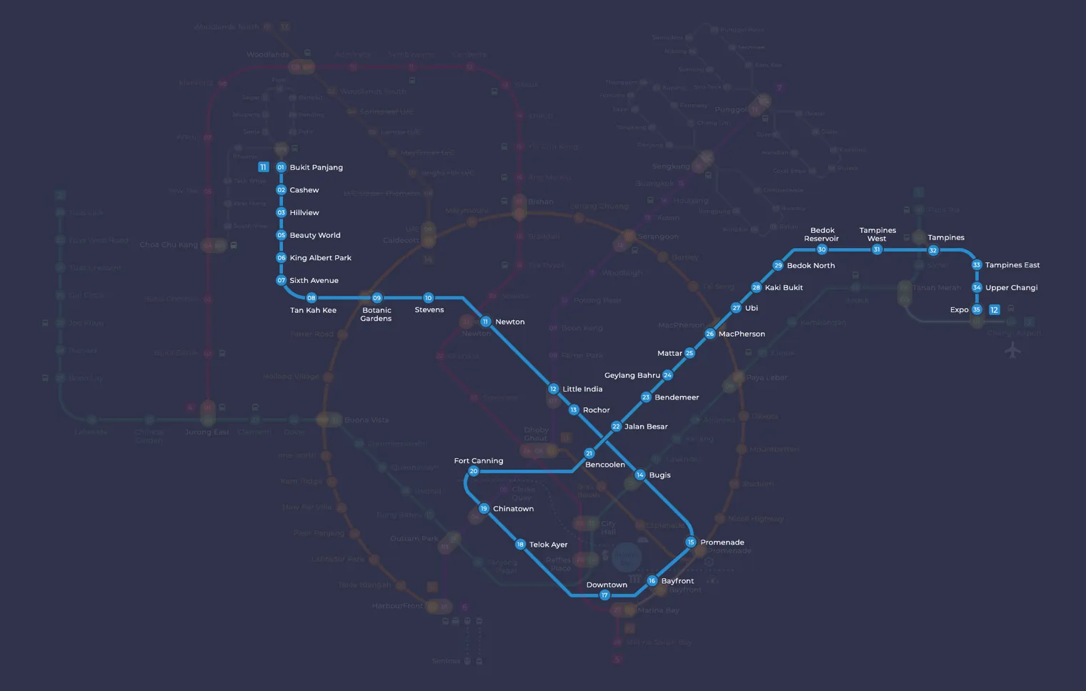
Bukit Panjang MRT station at a glance
| Station codes | DT1BP6 |
|---|---|
| Lines | Downtown Line Bukit Panjang LRT |
| Line colour | Blue line (Downtown Line) Grey line (Bukit Panjang LRT) |
| Interchange | Yes, change between 2 lines here |
| Chinese name | 武吉班让 |
| Tamil name | புக்கிட் பாஞ்சாங் |
| Opened | 6 November 1999 (27 years ago) |
| Operator | SMRT Trains and SBS Transit |
| Station type | Underground |
| Platforms | 4 (1 island platform, 2 side platforms) |
| Address | 950 Upper Bukit Timah Road, Singapore 678213 |
| Daily ridership | About 36,263 passengers a day (2024) |
| Next stations | |
| Train times | Downtown Line: first train leaves the terminus at 5:30 AM, last train 11:40 PM Full first and last train guide |
Opening date, operator and ridership figures are LTA data as recorded on Wikipedia.
See Bukit Panjang on the map. The interactive map opens with this station highlighted, so you can trace the route from where you are.
The Downtown Line platforms are underground, in a station built over three levels. The LRT stop has the barrel roof found at other stations on the Bukit Panjang LRT. The two are separate stations joined by an unpaid link bridge at the LRT mezzanine, so you tap out of one and tap in at the other. The fare system still counts this as one journey as long as the change takes no more than 15 minutes. Most passengers are local residents travelling towards the city, people switching between the LRT loop and the Downtown Line, and shoppers heading to the malls around the junction.
History of Bukit Panjang MRT station
The LRT platforms opened on 6 November 1999 together with the rest of the Bukit Panjang LRT. The Downtown Line followed on 27 December 2015, a few months earlier than planned. While it was being planned, the underground station went by the working name Petir, and Bukit Panjang was confirmed as its name in 2009. Only two entrances were planned at first, but residents of the Senja area asked their Members of Parliament for a third, and Exit C opened on 9 February 2018 with access to Bukit Panjang Road.
Inside Bukit Panjang MRT station
The Downtown Line station is fully barrier-free, with lifts, wheelchair-accessible toilets, wider faregates and tactile flooring to guide visually impaired passengers. Its entrances are shaped like pavilions along a park connector. On the LRT side, platform barriers were fitted in 2015 to stop people falling onto the tracks, and ceiling fans were added above the platforms in 2018.
For most people, Bukit Panjang MRT station is the way into the shops and services at the heart of the estate. These are the main places within a short walk:
- Hillion Mall and Bukit Panjang Plaza are right beside the station, with shopping and meals.
- Kopitiam and Choh Dee Place offer cheaper local food nearby.
- Bukit Panjang Public Library is a few minutes away on foot.
- Junction 10 is a little further along.
The bus interchange next door makes Bukit Panjang MRT station a practical starting point for trips deeper into the surrounding neighbourhoods.
Around Bukit Panjang MRT station
Bukit Panjang station sits at the heart of a largely residential town in the north-west of Singapore, with a strong focus on everyday amenities and retail. The immediate surroundings are dominated by shopping options such as Hillion Mall and Bukit Panjang Plaza, serving the local community. Several food centres and a public library round out the neighbourhood, making it a convenient base for residents and visitors alike.
| Place | Type | Distance | Why go |
|---|---|---|---|
| Hillion Mall | Shopping mall | About 60 m (~1 min walk) | Visit Hillion Mall for a range of shops, eateries and daily essentials. |
| Bukit Panjang Bus Interchange | Bus interchange | About 70 m (~1 min walk) | Use Bukit Panjang Bus Interchange to connect to bus services across the region. |
| Kopitiam | Food centre | About 80 m (~1 min walk) | Head to Kopitiam for local food court dining and quick meals. |
| Bukit Panjang Plaza | Shopping mall | About 140 m (~2 min walk) | Bukit Panjang Plaza offers retail shops and services for everyday needs. |
| Choh Dee Place | Food centre | About 190 m (~3 min walk) | Choh Dee Place is a food centre for local hawker meals and drinks. |
| Bukit Panjang Public Library | Library | About 260 m (~4 min walk) | Bukit Panjang Public Library is a good spot for books, study and community programmes. |
| Food Street | Food centre | About 310 m (~5 min walk) | Food Street is a hawker area suitable for local food and casual dining. |
| Junction 10 | Shopping mall | About 430 m (~7 min walk) | Junction 10 is a neighbourhood mall with shops, dining and lifestyle options. |
Places and straight-line distances from OpenStreetMap data (© OpenStreetMap contributors). Actual walking routes may be longer.
How to get to Bukit Panjang by MRT
Worked out from the network map. Stop counts are station to station and do not include walking or waiting time.
| From Changi Airport | Take the East West Line from Changi Airport to Bugis (10 stops), then change to the Downtown Line from Bugis to Bukit Panjang (13 stops). About 23 stops with 1 change. |
|---|---|
| From Orchard | Take the North South Line from Orchard to Newton (1 stop), then change to the Downtown Line from Newton to Bukit Panjang (10 stops). About 11 stops with 1 change. |
| From City Hall | Take the North South Line from City Hall to Newton (4 stops), then change to the Downtown Line from Newton to Bukit Panjang (10 stops). About 14 stops with 1 change. |
| From Jurong East | Take the North South Line from Jurong East to Choa Chu Kang (3 stops), then change to the Bukit Panjang LRT from Choa Chu Kang to Bukit Panjang (5 stops). About 8 stops with 1 change. |
| From Woodlands | Take the North South Line from Woodlands to Choa Chu Kang (4 stops), then change to the Bukit Panjang LRT from Choa Chu Kang to Bukit Panjang (5 stops). About 9 stops with 1 change. |
| From HarbourFront | Take the North East Line from HarbourFront to Little India (5 stops), then change to the Downtown Line from Little India to Bukit Panjang (11 stops). About 16 stops with 1 change. |
Fares from Bukit Panjang MRT station
A trip from Bukit Panjang to Changi Airport (about 34 km) costs S$2.50 on an adult SimplyGo or EZ-Link card. Fares are charged by distance, so the table below shows the estimated adult card fare from Bukit Panjang to the main hubs, the early bird fare for journeys that start before 7.45am on weekdays, and the fare that applies from 26 December 2026.
| To | Distance | Adult card | Before 7.45am | From 26 Dec 2026 |
|---|---|---|---|---|
| Changi Airport | about 34 km, 23 stops | S$2.50 | S$2.00 | S$2.63 |
| Orchard | about 15 km, 11 stops | S$2.07 | S$1.57 | S$2.20 |
| City Hall | about 17 km, 14 stops | S$2.15 | S$1.65 | S$2.28 |
| Raffles Place | about 18 km, 15 stops | S$2.20 | S$1.70 | S$2.33 |
| Jurong East | about 10 km, 8 stops | S$1.86 | S$1.36 | S$1.99 |
| Woodlands | about 12 km, 9 stops | S$1.94 | S$1.44 | S$2.07 |
| HarbourFront | about 21 km, 16 stops | S$2.33 | S$1.83 | S$2.46 |
| Marina Bay | about 19 km, 16 stops | S$2.27 | S$1.77 | S$2.40 |
Estimated from the route distance between stations and the Public Transport Council fare table in force from 27 December 2025. The exact fare can differ by one band. Cash fares are higher. Use the fare calculator for any other journey, or check your fare on the SimplyGo app.
Tips for using Bukit Panjang MRT station
- Hillion Mall, Bukit Panjang Bus Interchange and Kopitiam are all within roughly a minute's walk, so these are easy to reach on foot without much planning.
- Bukit Panjang Plaza and Choh Dee Place are slightly further but still comfortably walkable within a few minutes for most visitors.
- Junction 10 is the furthest point on this list at around 430 metres, so allow at least 7 to 10 minutes on foot, or consider taking a connecting bus from the interchange.
- This station serves as both a Downtown Line terminus and a Bukit Panjang LRT interchange, so during peak hours the platforms and surrounding areas can be busy and you should allow a little extra time.
All stations on the Downtown Line
In order along the line, with Bukit Panjang marked. Stations with their own guide are linked.
| Code | Station | Interchange |
|---|---|---|
| DT1 | Bukit Panjang (you are here) | DT / BP |
| DT2 | Cashew | None |
| DT3 | Hillview | None |
| DT4 | Hume | None |
| DT5 | Beauty World | None |
| DT6 | King Albert Park | None |
| DT7 | Sixth Avenue | None |
| DT8 | Tan Kah Kee | None |
| DT9 | Botanic Gardens | DT / CC |
| DT10 | Stevens | DT / TE |
| DT11 | Newton | NS / DT |
| DT12 | Little India | DT / NE |
| DT13 | Rochor | None |
| DT14 | Bugis | DT / EW |
| DT15 | Promenade | CC / DT |
| DT16 | Bayfront | CE / DT |
| DT17 | Downtown | None |
| DT18 | Telok Ayer | None |
| DT19 | Chinatown | DT / NE |
| DT20 | Fort Canning | None |
| DT21 | Bencoolen | None |
| DT22 | Jalan Besar | None |
| DT23 | Bendemeer | None |
| DT24 | Geylang Bahru | None |
| DT25 | Mattar | None |
| DT26 | MacPherson | CC / DT |
| DT27 | Ubi | None |
| DT28 | Kaki Bukit | None |
| DT29 | Bedok North | None |
| DT30 | Bedok Reservoir | None |
| DT31 | Tampines West | None |
| DT32 | Tampines | EW / DT |
| DT33 | Tampines East | None |
| DT34 | Upper Changi | None |
| DT35 | Expo | DT / CG |
Read the full Downtown Line guide.
All stations on the Bukit Panjang LRT
In order along the line, with Bukit Panjang marked. Stations with their own guide are linked.
| Code | Station | Interchange |
|---|---|---|
| BP1 | Choa Chu Kang | NS / BP |
| BP2 | South View | None |
| BP3 | Keat Hong | None |
| BP4 | Teck Whye | None |
| BP5 | Phoenix | None |
| BP6 | Bukit Panjang (you are here) | DT / BP |
| BP7 | Petir | None |
| BP8 | Pending | None |
| BP9 | Bangkit | None |
| BP10 | Fajar | None |
| BP11 | Segar | None |
| BP12 | Jelapang | None |
| BP13 | Senja | None |
Read the full Bukit Panjang LRT guide.
Bukit Panjang MRT station: common questions
Which line is Bukit Panjang MRT station on?
Bukit Panjang is on the Downtown Line and the Bukit Panjang LRT. Its station codes are DT1 and BP6.
Is Bukit Panjang an interchange station?
Yes. You can change between the Downtown Line and the Bukit Panjang LRT inside the station without leaving the paid area.
What time is the first and last train at Bukit Panjang?
Times below are for the first and last train leaving the line terminus; trains reach Bukit Panjang a few minutes later depending on its position on the line. Downtown Line first train 5:30 AM, last train 11:40 PM. Check the operator for holiday changes.
What is near Bukit Panjang MRT station?
The station is surrounded by several amenities including Hillion Mall, Bukit Panjang Bus Interchange, Kopitiam, Bukit Panjang Plaza, Choh Dee Place, Bukit Panjang Public Library, Food Street and Junction 10, all within an approximate 7-minute walk.
Which mall or food centre is closest to Bukit Panjang station?
Hillion Mall is the closest shopping mall at approximately 60 metres, and Kopitiam is the closest food centre at approximately 80 metres, both roughly a 1-minute walk.
How far is Junction 10 from Bukit Panjang station?
Junction 10 is approximately 430 metres from the station, which is roughly a 7-minute walk. You may prefer to take a bus from Bukit Panjang Bus Interchange if you would rather not walk.
How do I get to Bukit Panjang from Changi Airport by MRT?
Take the East West Line from Changi Airport to Bugis (10 stops), then change to the Downtown Line from Bugis to Bukit Panjang (13 stops). About 23 stops with 1 change.
Sources: station codes, line colours and interchanges from the LTA rail system map; operating hours from SMRT and SBS Transit. Last reviewed October 2026.
News and guides mentioning Bukit Panjang
- Sketching on the MRT: What If Someone Draws Your Child? 6 Nov 2026
- Vomit on MRT: What to Do When Your Cabin Is Soiled 6 Nov 2026
- MRT shopping malls: Direct station connections in Singapore 6 Nov 2026
- N95 masks for rail and bus workers amid haze: where to get them 6 Nov 2026
Plan the rest of the trip
Every station on the Downtown Line and the Bukit Panjang LRT is listed on its line guide, with the full route and interchanges. For times, see the first and last train guide, and for the whole network in one view use the interactive Singapore MRT map or the PDF map.
Exits and buses at Bukit Panjang station
Bukit Panjang has 4 mapped exits (A1 to C). The letters match the signs inside the station; the landmark beside each one is the closest mapped place to that entrance, so pick the exit that comes up nearest to where you are going.
- Exit A1: closest to Bukit Panjang Plaza (about 16 m from the entrance)
- Exit A2: closest to Bukit Panjang Plaza (about 13 m from the entrance)
- Exit B: closest to Bukit Panjang Plaza (about 76 m from the entrance)
- Exit C
Bus stops within 250 m of Bukit Panjang station
| Bus stop | Stop code | Services | From station |
|---|---|---|---|
| Opposite Bukit Panjang Station | 44859 | 177 | 35 m |
| Bukit Panjang Interchange | 45009 | 176, 180, 180A, 455, 920, 922, 970, 972, 972A, 972M, 973, 973A, 975, 975C, 976, 979 | 40 m |
| After Bukit Panjang Station | 44031 | 979, 983 | 89 m |
| Bukit Panjang Station Exit A/LRT | 44029 | 67, 170, 171, 176, 178, 180, 180A, 961, 961M, 963, 970, 974, 974A | 138 m |
| Opposite Blk 180 | 44731 | 75, 171, 960, 963, 963R, 963e | 162 m |
| Bukit Panjang Station Exit B | 44021 | 67, 170, 176, 177, 178, 961, 961M, 963, 970 | 164 m |
Exits and bus services come from OpenStreetMap and can change when roads or routes are revised; check the board at the stop or the operator app before relying on a service late at night. For the nearest station to where you are now, use the MRT near me finder.
Places to visit from Bukit Panjang station
See every guide on how to get to Singapore's attractions, hospitals and malls by MRT, with routes and fares from Changi Airport, Orchard and the city.
MRT routes from Bukit Panjang
Routes to Bukit Panjang: Orchard to Bukit Panjang.
More on the MRT routes hub.