
Senja LRT Station
Senja LRT station is a stop on the Bukit Panjang LRT, with the station code BP13, serving the Bukit Panjang estate in the north-west of Singapore. The whole line runs on a raised guideway, so this is an elevated station: passengers go up from street level to reach the platform rather than down into a tunnel.
Senja on the Bukit Panjang LRT map
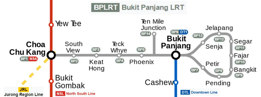
Senja LRT station at a glance
| Station codes | BP13 |
|---|---|
| Lines | Bukit Panjang LRT |
| Line colour | Grey line (Bukit Panjang LRT) |
| Interchange | No, single line station |
| Chinese name | 信佳 |
| Tamil name | சென்ஜா |
| Next stations |
See Senja on the map. The interactive map opens with this station highlighted, so you can trace the route from where you are.
Most people who use the station live in the nearby estate and ride the light rail for short journeys around Bukit Panjang, or for the trip to Choa Chu Kang station, where the line meets the MRT network. Trains on the line are fully automated and run in two-car sets, which suits the quick local hops most riders make between home, the shops and onward connections.
History of Senja LRT station
Senja LRT station has carried passengers since the Bukit Panjang LRT opened on 6 November 1999, when it became the first LRT line in Singapore. Before construction, an exhibition in 1996 let members of the public vote on the colours of the trains and the shape of the station roofs. The line is now partway through a major renewal of its signalling, power rails and trains, which is due to be finished in 2026 and is intended to shorten waiting times between trains.
Inside Senja LRT station
The station is compact, with a single level of platforms above the road and a short walk from the fare gates to the trains. Platform barriers have been fitted along the edges of the platforms, as at every other stop on the Bukit Panjang LRT, which keeps waiting passengers away from the guideway.
For residents and visitors, Senja LRT station is a convenient base for the Bukit Panjang town centre, which lies within an easy walk. Food Street, a food centre about 300 m away, is the closest place for a meal, while Kopitiam Corner and Kopitiam offer further food options within about eight minutes on foot.
For shopping, Junction 10 and Bukit Panjang Plaza are both around six minutes away, and Hillion Mall is a little further at about 480 m. Bukit Panjang Public Library sits roughly 410 m from the station, making it practical for a study session or to return books, and Bukit Panjang Bus Interchange, about seven minutes away on foot, is useful when a bus is the better choice for your onward journey.
Around Senja LRT station
Senja LRT station sits within a well-established residential town in Bukit Panjang, where shoppers and residents are well served by nearby malls including Bukit Panjang Plaza and Hillion Mall. The area also offers a range of food centres and a public library, making it a practical neighbourhood hub for daily errands and leisure. It is predominantly a suburban residential district with strong amenities concentrated within a short walk of the station.
| Place | Type | Distance | Why go |
|---|---|---|---|
| Food Street | Food centre | About 300 m (~5 min walk) | Visit for a variety of cooked food stalls serving local hawker fare. |
| Junction 10 | Shopping mall | About 360 m (~6 min walk) | Head here for retail shops, supermarkets and everyday shopping needs. |
| Bukit Panjang Plaza | Shopping mall | About 370 m (~6 min walk) | A convenient mall for shopping, dining and personal services. |
| Kopitiam Corner | Food centre | About 380 m (~6 min walk) | A food centre offering local meals and kopitiam-style drinks. |
| Bukit Panjang Public Library | Library | About 410 m (~7 min walk) | Borrow books, use study spaces or access community library services. |
| Bukit Panjang Bus Interchange | Bus interchange | About 460 m (~7 min walk) | Board a wide range of bus services connecting to other parts of Singapore. |
| Kopitiam | Food centre | About 470 m (~8 min walk) | Drop by for local coffee shop meals and light refreshments. |
| Hillion Mall | Shopping mall | About 480 m (~8 min walk) | Explore a mix of retail, dining and lifestyle options in this mall. |
Places and straight-line distances from OpenStreetMap data (© OpenStreetMap contributors). Actual walking routes may be longer.
How to get to Senja by LRT
Worked out from the network map. Stop counts are station to station and do not include walking or waiting time.
| From Changi Airport | Take the East West Line from Changi Airport to Bugis (10 stops), then change to the Downtown Line from Bugis to Bukit Panjang (13 stops), then change to the Bukit Panjang LRT from Bukit Panjang to Senja (1 stop). About 24 stops with 2 changes. |
|---|---|
| From Orchard | Take the North South Line from Orchard to Newton (1 stop), then change to the Downtown Line from Newton to Bukit Panjang (10 stops), then change to the Bukit Panjang LRT from Bukit Panjang to Senja (1 stop). About 12 stops with 2 changes. |
| From City Hall | Take the North South Line from City Hall to Newton (4 stops), then change to the Downtown Line from Newton to Bukit Panjang (10 stops), then change to the Bukit Panjang LRT from Bukit Panjang to Senja (1 stop). About 15 stops with 2 changes. |
| From Jurong East | Take the North South Line from Jurong East to Choa Chu Kang (3 stops), then change to the Bukit Panjang LRT from Choa Chu Kang to Senja (6 stops). About 9 stops with 1 change. |
| From Woodlands | Take the North South Line from Woodlands to Choa Chu Kang (4 stops), then change to the Bukit Panjang LRT from Choa Chu Kang to Senja (6 stops). About 10 stops with 1 change. |
| From HarbourFront | Take the North East Line from HarbourFront to Little India (5 stops), then change to the Downtown Line from Little India to Bukit Panjang (11 stops), then change to the Bukit Panjang LRT from Bukit Panjang to Senja (1 stop). About 17 stops with 2 changes. |
Fares from Senja LRT station
A trip from Senja to Changi Airport (about 35 km) costs S$2.51 on an adult SimplyGo or EZ-Link card. Fares are charged by distance, so the table below shows the estimated adult card fare from Senja to the main hubs, the early bird fare for journeys that start before 7.45am on weekdays, and the fare that applies from 26 December 2026.
| To | Distance | Adult card | Before 7.45am | From 26 Dec 2026 |
|---|---|---|---|---|
| Changi Airport | about 35 km, 24 stops | S$2.51 | S$2.01 | S$2.64 |
| Orchard | about 15 km, 12 stops | S$2.11 | S$1.61 | S$2.24 |
| City Hall | about 18 km, 15 stops | S$2.20 | S$1.70 | S$2.33 |
| Raffles Place | about 19 km, 16 stops | S$2.24 | S$1.74 | S$2.37 |
| Jurong East | about 10 km, 9 stops | S$1.90 | S$1.40 | S$2.03 |
| Woodlands | about 12 km, 10 stops | S$1.98 | S$1.48 | S$2.11 |
| HarbourFront | about 22 km, 17 stops | S$2.33 | S$1.83 | S$2.46 |
| Marina Bay | about 20 km, 17 stops | S$2.27 | S$1.77 | S$2.40 |
Estimated from the route distance between stations and the Public Transport Council fare table in force from 27 December 2025. The exact fare can differ by one band. Cash fares are higher. Use the fare calculator for any other journey, or check your fare on the SimplyGo app.
Tips for using Senja LRT station
- Most destinations on the verified list are within an eight-minute walk of the station, so walking is a practical option for nearby errands.
- The Bukit Panjang Bus Interchange is roughly seven minutes on foot and provides connections to many parts of Singapore if you need to travel beyond the LRT network.
- During peak hours the LRT can be busy, so allow a little extra time if you are making onward connections at Choa Chu Kang station.
- Food Street and Junction 10 are among the closer destinations, making them convenient first stops after alighting if you need a quick meal or some shopping.
All stations on the Bukit Panjang LRT
In order along the line, with Senja marked. Stations with their own guide are linked.
| Code | Station | Interchange |
|---|---|---|
| BP1 | Choa Chu Kang | NS / BP |
| BP2 | South View | None |
| BP3 | Keat Hong | None |
| BP4 | Teck Whye | None |
| BP5 | Phoenix | None |
| BP6 | Bukit Panjang | DT / BP |
| BP7 | Petir | None |
| BP8 | Pending | None |
| BP9 | Bangkit | None |
| BP10 | Fajar | None |
| BP11 | Segar | None |
| BP12 | Jelapang | None |
| BP13 | Senja (you are here) | None |
Read the full Bukit Panjang LRT guide.
Senja LRT station: common questions
Which line is Senja LRT station on?
Senja is on the Bukit Panjang LRT. Its station code is BP13.
Is Senja an interchange station?
No. Senja is served by the Bukit Panjang LRT only. The nearest interchange is shown in the next stations row above.
What is near Senja LRT station?
Senja LRT station has several amenities within walking distance, including Food Street, Junction 10, Bukit Panjang Plaza, Bukit Panjang Public Library, Bukit Panjang Bus Interchange and Hillion Mall. There are also a few food centres nearby, such as Kopitiam Corner and Kopitiam.
Which shopping mall or food centre is closest to Senja station?
Food Street is the closest food centre at approximately 300 metres, while Junction 10 is the nearest shopping mall at approximately 360 metres, both roughly a five to six minute walk.
How far is Hillion Mall from Senja LRT station?
Hillion Mall is approximately 480 metres from Senja LRT station, which is roughly an eight-minute walk. Note that all distances are approximate.
How do I get to Senja from Changi Airport by LRT?
Take the East West Line from Changi Airport to Bugis (10 stops), then change to the Downtown Line from Bugis to Bukit Panjang (13 stops), then change to the Bukit Panjang LRT from Bukit Panjang to Senja (1 stop). About 24 stops with 2 changes.
Sources: station codes, line colours and interchanges from the LTA rail system map; operating hours from SMRT and SBS Transit. Last reviewed October 2026.
News and guides mentioning Senja
- Singapore MRT history: from 5 stations in 1987 to 130+ today 6 Nov 2026
- シンガポール地下鉄(MRT)路線図 2026(日本語ガイド) 4 Oct 2026
- MRT Map (2017) 11 Aug 2023
- MRT Map (2006) 11 Aug 2023
Plan the rest of the trip
Every station on the Bukit Panjang LRT is listed on its line guide, with the full route and interchanges. For times, see the first and last train guide, and for the whole network in one view use the interactive Singapore MRT map or the PDF map.
Exits and buses at Senja station
Bus stops within 250 m of Senja station
| Bus stop | Stop code | Services | From station |
|---|---|---|---|
| Blk 541A Carpark | 44649 | 920, 922, 972, 972M, 976 | 93 m |
| Blk 602 | 44641 | 920, 922, 972, 972A, 972M, 976 | 115 m |
| Blk 610 | 44799 | 920, 972, 972M, 976 | 178 m |
| West View Primary School | 44791 | 920, 972, 972A, 972M, 976 | 219 m |
Exits and bus services come from OpenStreetMap and can change when roads or routes are revised; check the board at the stop or the operator app before relying on a service late at night. For the nearest station to where you are now, use the MRT near me finder.
Places to visit from Senja station
See every guide on how to get to Singapore's attractions, hospitals and malls by MRT, with routes and fares from Changi Airport, Orchard and the city.