
South View LRT Station
South View LRT station is a stop on the Bukit Panjang LRT line, carrying the station code BP2. It sits within a quiet residential area in the western part of Singapore, serving the Housing Development Board estates of Bukit Panjang. The station is not an interchange and forms part of the loop system that connects the surrounding neighbourhood to the broader MRT network, providing residents with a convenient way to travel without relying on road transport.
South View on the Bukit Panjang LRT map
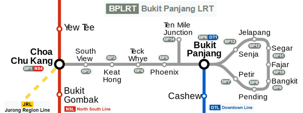
South View LRT station at a glance
| Station codes | BP2 |
|---|---|
| Lines | Bukit Panjang LRT |
| Line colour | Grey line (Bukit Panjang LRT) |
| Interchange | No, single line station |
| Chinese name | 南景 |
| Tamil name | சவுத் வியூ |
| Next stations |
See South View on the map. The interactive map opens with this station highlighted, so you can trace the route from where you are.
From South View, passengers can reach neighbouring stations Keat Hong and Choa Chu Kang directly along the Bukit Panjang LRT line. Choa Chu Kang is the key connection point in this part of the network, offering access to the North South Line and the Downtown Line, which together open up routes across much of Singapore. Travelling in the other direction towards Keat Hong continues the loop through the residential areas of Bukit Panjang.
The station is surrounded primarily by HDB residential blocks and the everyday amenities that come with a mature public housing estate, including neighbourhood shops, void deck spaces, and local eateries within easy walking distance. The area is largely domestic in character, making it a practical stop for residents going about daily routines rather than a destination for visitors. Those looking for larger retail or recreational options would typically continue to Choa Chu Kang, which has more substantial facilities nearby.
Around South View LRT station
South View station sits within a well-established residential area in Choa Chu Kang, surrounded largely by public housing estates. The neighbourhood offers everyday amenities within easy reach, including Keat Hong Wet Market and Keat Hong Shopping Centre for daily necessities. A short walk further brings residents to the larger Lot One Shoppers' Mall, which serves the broader Choa Chu Kang town centre.
| Place | Type | Distance | Why go |
|---|---|---|---|
| Keat Hong Wet Market | Market / hawker centre | About 320 m (~5 min walk) | Visit for fresh produce, meat, and vegetables from a traditional wet market. |
| Keat Hong Shopping Centre | Shopping mall | About 340 m (~6 min walk) | A neighbourhood mall with shops catering to everyday household and personal needs. |
| Keat Hong Food Centre & Market | Food centre | About 400 m (~7 min walk) | A popular spot for affordable local hawker meals in a food centre setting. |
| Lot One Shoppers' Mall | Shopping mall | About 540 m (~9 min walk) | A larger suburban shopping mall with a wider range of retail and dining options. |
| Choa Chu Kang Public Library | Library | About 540 m (~9 min walk) | Borrow books, use study spaces, or attend community programmes at this public library. |
| CCK 302 Foodhouse | Food centre | About 550 m (~9 min walk) | A casual foodhouse offering a variety of local cooked food options. |
| Food Junction | Food centre | About 570 m (~9 min walk) | A food court with multiple stalls serving a range of local and international dishes. |
| Sunshine Place | Shopping mall | About 740 m (~12 min walk) | A smaller shopping mall providing additional retail and dining choices nearby. |
Places and straight-line distances from OpenStreetMap data (© OpenStreetMap contributors). Actual walking routes may be longer.
How to get to South View by LRT
Worked out from the network map. Stop counts are station to station and do not include walking or waiting time.
| From Changi Airport | Take the East West Line from Changi Airport to Jurong East (22 stops), then change to the North South Line from Jurong East to Choa Chu Kang (3 stops), then change to the Bukit Panjang LRT from Choa Chu Kang to South View (1 stop). About 26 stops with 2 changes. |
|---|---|
| From Orchard | Take the North South Line from Orchard to Choa Chu Kang (17 stops), then change to the Bukit Panjang LRT from Choa Chu Kang to South View (1 stop). About 18 stops with 1 change. |
| From City Hall | Take the East West Line from City Hall to Jurong East (11 stops), then change to the North South Line from Jurong East to Choa Chu Kang (3 stops), then change to the Bukit Panjang LRT from Choa Chu Kang to South View (1 stop). About 15 stops with 2 changes. |
| From Jurong East | Take the North South Line from Jurong East to Choa Chu Kang (3 stops), then change to the Bukit Panjang LRT from Choa Chu Kang to South View (1 stop). About 4 stops with 1 change. |
| From Woodlands | Take the North South Line from Woodlands to Choa Chu Kang (4 stops), then change to the Bukit Panjang LRT from Choa Chu Kang to South View (1 stop). About 5 stops with 1 change. |
| From HarbourFront | Take the North East Line from HarbourFront to Outram Park (1 stop), then change to the East West Line from Outram Park to Jurong East (8 stops), then change to the North South Line from Jurong East to Choa Chu Kang (3 stops), then change to the Bukit Panjang LRT from Choa Chu Kang to South View (1 stop). About 13 stops with 3 changes. |
Fares from South View LRT station
A trip from South View to Changi Airport (about 43 km) costs S$2.57 on an adult SimplyGo or EZ-Link card. Fares are charged by distance, so the table below shows the estimated adult card fare from South View to the main hubs, the early bird fare for journeys that start before 7.45am on weekdays, and the fare that applies from 26 December 2026.
| To | Distance | Adult card | Before 7.45am | From 26 Dec 2026 |
|---|---|---|---|---|
| Changi Airport | about 43 km, 26 stops | S$2.57 | S$2.07 | S$2.70 |
| Orchard | about 17 km, 15 stops | S$2.15 | S$1.65 | S$2.28 |
| City Hall | about 24 km, 15 stops | S$2.40 | S$1.90 | S$2.53 |
| Raffles Place | about 23 km, 14 stops | S$2.36 | S$1.86 | S$2.49 |
| Jurong East | about 7 km, 4 stops | S$1.75 | S$1.25 | S$1.88 |
| Woodlands | about 9 km, 5 stops | S$1.86 | S$1.36 | S$1.99 |
| HarbourFront | about 24 km, 13 stops | S$2.38 | S$1.88 | S$2.51 |
| Marina Bay | about 24 km, 15 stops | S$2.38 | S$1.88 | S$2.51 |
Estimated from the route distance between stations and the Public Transport Council fare table in force from 27 December 2025. The exact fare can differ by one band. Cash fares are higher. Use the fare calculator for any other journey, or check your fare on the SimplyGo app.
Tips for using South View LRT station
- Keat Hong Wet Market and Keat Hong Shopping Centre are the closest destinations and are manageable on foot for most visitors.
- Lot One Shoppers' Mall, Choa Chu Kang Public Library, and CCK 302 Foodhouse are roughly a 9-minute walk away, so consider taking local bus services if you prefer to avoid the longer walk.
- During morning peak hours and weekend lunch times, the areas around the food centres can get busy, so allow extra time if you are heading there.
- South View is a non-interchange LRT station, so if you need to connect to the MRT network, ride the Bukit Panjang LRT to Choa Chu Kang station, which links to the North-South Line and Downtown Line.
All stations on the Bukit Panjang LRT
In order along the line, with South View marked. Stations with their own guide are linked.
| Code | Station | Interchange |
|---|---|---|
| BP1 | Choa Chu Kang | NS / BP |
| BP2 | South View (you are here) | None |
| BP3 | Keat Hong | None |
| BP4 | Teck Whye | None |
| BP5 | Phoenix | None |
| BP6 | Bukit Panjang | DT / BP |
| BP7 | Petir | None |
| BP8 | Pending | None |
| BP9 | Bangkit | None |
| BP10 | Fajar | None |
| BP11 | Segar | None |
| BP12 | Jelapang | None |
| BP13 | Senja | None |
Read the full Bukit Panjang LRT guide.
South View LRT station: common questions
Which line is South View LRT station on?
South View is on the Bukit Panjang LRT. Its station code is BP2.
Is South View an interchange station?
No. South View is served by the Bukit Panjang LRT only. The nearest interchange is shown in the next stations row above.
What is near South View LRT station?
The station is close to Keat Hong Wet Market, Keat Hong Shopping Centre, and Keat Hong Food Centre and Market, all within approximately 400 metres. A longer walk of around 9 to 12 minutes brings you to Lot One Shoppers' Mall, Choa Chu Kang Public Library, and Sunshine Place.
Which mall or food centre is closest to South View station?
Keat Hong Shopping Centre is the closest mall, at approximately 340 metres or a 6-minute walk. For food, Keat Hong Wet Market is the nearest option at roughly 320 metres away.
How far is Lot One Shoppers' Mall from South View station?
Lot One Shoppers' Mall is approximately 540 metres from South View station, which works out to roughly a 9-minute walk. Taking a local bus service can reduce the travel time if preferred.
How do I get to South View from Changi Airport by LRT?
Take the East West Line from Changi Airport to Jurong East (22 stops), then change to the North South Line from Jurong East to Choa Chu Kang (3 stops), then change to the Bukit Panjang LRT from Choa Chu Kang to South View (1 stop). About 26 stops with 2 changes.
Sources: station codes, line colours and interchanges from the LTA rail system map; operating hours from SMRT and SBS Transit. Last reviewed September 2026.
Plan the rest of the trip
Every station on the Bukit Panjang LRT is listed on its line guide, with the full route and interchanges. For times, see the first and last train guide, and for the whole network in one view use the interactive Singapore MRT map or the PDF map.