
Segar LRT Station
Segar LRT station (BP11) is a stop on the Bukit Panjang LRT, the light rail line that runs through the housing estates of Bukit Panjang and Choa Chu Kang in the north-west of Singapore. Like every station on this line, it is elevated, with trains running on a raised guideway above street level rather than underground.
Segar on the Bukit Panjang LRT map
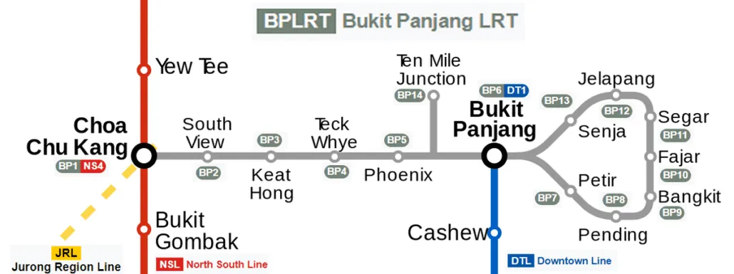
Segar LRT station at a glance
| Station codes | BP11 |
|---|---|
| Lines | Bukit Panjang LRT |
| Line colour | Grey line (Bukit Panjang LRT) |
| Interchange | No, single line station |
| Chinese name | 实加 |
| Tamil name | செகார் |
| Next stations |
See Segar on the map. The interactive map opens with this station highlighted, so you can trace the route from where you are.
The station mainly serves people who live in the surrounding Bukit Panjang neighbourhood. Many use it for short trips within the estate, or to reach Choa Chu Kang station, where the light rail line meets the MRT network for longer journeys across the island. Trains are fully automated and run as two-car sets, so services are frequent but compact compared with the main MRT lines.
History of Segar LRT station
The station opened with the rest of the Bukit Panjang LRT on 6 November 1999, when this became the first light rail line to carry passengers in Singapore. Before construction, the public was invited to an exhibition where visitors could vote on the colours of the trains and the shape of the station roofs. The line has since gone through a long renewal programme, with new signalling, power rails and trains scheduled to be completed in 2026.
Inside Segar LRT station
Platform barriers have been fitted at all stations on the line since 2017, which keeps waiting passengers safely back from the guideway. Because the line is undergoing a major upgrade, passengers may notice newer trains running alongside refurbished ones during the changeover period.
For residents and visitors alike, Segar LRT station is a practical base for everyday errands in this part of Bukit Panjang. Food Park is the closest place to eat, about a three-minute walk away, and Zhenghua Community Club is roughly four minutes on foot for classes, events and community services.
A short walk of around seven minutes brings you to Fajar Market for fresh produce and to Greenridge Shopping Centre for daily shopping, while Koufu (Fajar) and Fajar Shopping Centre sit at a similar distance. If you need a larger mall or a library, Bukit Panjang Plaza and Bukit Panjang Public Library are both about 17 minutes away on foot, so many people choose to ride the light rail for that part of the journey instead.
Around Segar LRT station
Segar station sits within a primarily residential neighbourhood in the Bukit Panjang area, surrounded by public housing estates and local amenities. The area caters well to everyday needs, with options such as the nearby Food Park and Zhenghua Community Club serving residents. A cluster of shopping and market facilities, including Greenridge Shopping Centre and Fajar Shopping Centre, can be found within a short walk.
| Place | Type | Distance | Why go |
|---|---|---|---|
| Food Park | Food centre | About 190 m (~3 min walk) | Visit for a range of local cooked food stalls in a food centre setting. |
| Zhenghua Community Club | Community club | About 260 m (~4 min walk) | Visit for community programmes, activities, and facilities for residents. |
| Koufu (Fajar) | Food centre | About 420 m (~7 min walk) | Visit for a variety of affordable local food options in a food court. |
| Fajar Market (wet market) | Market / hawker centre | About 450 m (~7 min walk) | Visit for fresh produce, groceries, and wet market goods. |
| Greenridge Shopping Centre | Shopping mall | About 460 m (~7 min walk) | Visit for everyday shopping, retail stores, and local services. |
| Fajar Shopping Centre | Shopping mall | About 460 m (~7 min walk) | Visit for shopping, dining, and general retail needs. |
| Bukit Panjang Plaza | Shopping mall | About 1040 m (~17 min walk) | Visit for a wider selection of shops, services, and dining options. |
| Bukit Panjang Public Library | Library | About 1060 m (~17 min walk) | Visit to borrow books, access resources, or use study facilities. |
Places and straight-line distances from OpenStreetMap data (© OpenStreetMap contributors). Actual walking routes may be longer.
How to get to Segar by LRT
Worked out from the network map. Stop counts are station to station and do not include walking or waiting time.
| From Changi Airport | Take the East West Line from Changi Airport to Bugis (10 stops), then change to the Downtown Line from Bugis to Bukit Panjang (13 stops), then change to the Bukit Panjang LRT from Bukit Panjang to Segar (3 stops). About 26 stops with 2 changes. |
|---|---|
| From Orchard | Take the North South Line from Orchard to Newton (1 stop), then change to the Downtown Line from Newton to Bukit Panjang (10 stops), then change to the Bukit Panjang LRT from Bukit Panjang to Segar (3 stops). About 14 stops with 2 changes. |
| From City Hall | Take the North South Line from City Hall to Newton (4 stops), then change to the Downtown Line from Newton to Bukit Panjang (10 stops), then change to the Bukit Panjang LRT from Bukit Panjang to Segar (3 stops). About 17 stops with 2 changes. |
| From Jurong East | Take the North South Line from Jurong East to Choa Chu Kang (3 stops), then change to the Bukit Panjang LRT from Choa Chu Kang to Segar (8 stops). About 11 stops with 1 change. |
| From Woodlands | Take the North South Line from Woodlands to Choa Chu Kang (4 stops), then change to the Bukit Panjang LRT from Choa Chu Kang to Segar (8 stops). About 12 stops with 1 change. |
| From HarbourFront | Take the North East Line from HarbourFront to Little India (5 stops), then change to the Downtown Line from Little India to Bukit Panjang (11 stops), then change to the Bukit Panjang LRT from Bukit Panjang to Segar (3 stops). About 19 stops with 2 changes. |
Fares from Segar LRT station
A trip from Segar to Changi Airport (about 36 km) costs S$2.52 on an adult SimplyGo or EZ-Link card. Fares are charged by distance, so the table below shows the estimated adult card fare from Segar to the main hubs, the early bird fare for journeys that start before 7.45am on weekdays, and the fare that applies from 26 December 2026.
| To | Distance | Adult card | Before 7.45am | From 26 Dec 2026 |
|---|---|---|---|---|
| Changi Airport | about 36 km, 26 stops | S$2.52 | S$2.02 | S$2.65 |
| Orchard | about 16 km, 14 stops | S$2.15 | S$1.65 | S$2.28 |
| City Hall | about 19 km, 17 stops | S$2.24 | S$1.74 | S$2.37 |
| Raffles Place | about 20 km, 18 stops | S$2.27 | S$1.77 | S$2.40 |
| Jurong East | about 11 km, 11 stops | S$1.94 | S$1.44 | S$2.07 |
| Woodlands | about 14 km, 12 stops | S$2.02 | S$1.52 | S$2.15 |
| HarbourFront | about 23 km, 19 stops | S$2.36 | S$1.86 | S$2.49 |
| Marina Bay | about 21 km, 19 stops | S$2.30 | S$1.80 | S$2.43 |
Estimated from the route distance between stations and the Public Transport Council fare table in force from 27 December 2025. The exact fare can differ by one band. Cash fares are higher. Use the fare calculator for any other journey, or check your fare on the SimplyGo app.
Tips for using Segar LRT station
- The Food Park is the closest food option at roughly 3 minutes on foot, making it convenient for a quick meal before or after your journey.
- Fajar Market, Fajar Shopping Centre, and Greenridge Shopping Centre are all approximately 7 minutes away on foot and can easily be combined into one trip.
- Bukit Panjang Plaza and Bukit Panjang Public Library are around 17 minutes away on foot, so consider using public transport to reach them if you prefer a shorter journey.
- During peak hours the Bukit Panjang LRT can be busy, so allow a little extra time when planning connections onward to the MRT network.
All stations on the Bukit Panjang LRT
In order along the line, with Segar marked. Stations with their own guide are linked.
| Code | Station | Interchange |
|---|---|---|
| BP1 | Choa Chu Kang | NS / BP |
| BP2 | South View | None |
| BP3 | Keat Hong | None |
| BP4 | Teck Whye | None |
| BP5 | Phoenix | None |
| BP6 | Bukit Panjang | DT / BP |
| BP7 | Petir | None |
| BP8 | Pending | None |
| BP9 | Bangkit | None |
| BP10 | Fajar | None |
| BP11 | Segar (you are here) | None |
| BP12 | Jelapang | None |
| BP13 | Senja | None |
Read the full Bukit Panjang LRT guide.
Segar LRT station: common questions
Which line is Segar LRT station on?
Segar is on the Bukit Panjang LRT. Its station code is BP11.
Is Segar an interchange station?
No. Segar is served by the Bukit Panjang LRT only. The nearest interchange is shown in the next stations row above.
What is near Segar LRT station?
Nearby places include the Food Park, Zhenghua Community Club, Koufu (Fajar), Fajar Market, Greenridge Shopping Centre, and Fajar Shopping Centre, all within approximately 7 minutes on foot. Bukit Panjang Plaza and Bukit Panjang Public Library are further away at roughly 17 minutes on foot.
Which food centre or mall is closest to Segar station?
The Food Park is the closest food centre, at approximately 190 metres or about 3 minutes on foot. For shopping, Greenridge Shopping Centre and Fajar Shopping Centre are both around 460 metres away, roughly a 7-minute walk.
How far is Bukit Panjang Plaza from Segar station?
Bukit Panjang Plaza is approximately 1,040 metres from Segar station in a straight line, which is roughly a 17-minute walk. You may wish to use public transport to get there more quickly.
How do I get to Segar from Changi Airport by LRT?
Take the East West Line from Changi Airport to Bugis (10 stops), then change to the Downtown Line from Bugis to Bukit Panjang (13 stops), then change to the Bukit Panjang LRT from Bukit Panjang to Segar (3 stops). About 26 stops with 2 changes.
Sources: station codes, line colours and interchanges from the LTA rail system map; operating hours from SMRT and SBS Transit. Last reviewed October 2026.
News and guides mentioning Segar
- シンガポール地下鉄(MRT)路線図 2026(日本語ガイド) 4 Oct 2026
- Power Bank Fire at Woodlands MRT: What Happened 22 Jul 2026
- Man Pleads Guilty to Rape Near Tuas West Road MRT 18 Jul 2026
- Segar LRT Death: Platform Barriers Under Review 9 Jul 2026
Plan the rest of the trip
Every station on the Bukit Panjang LRT is listed on its line guide, with the full route and interchanges. For times, see the first and last train guide, and for the whole network in one view use the interactive Singapore MRT map or the PDF map.
Exits and buses at Segar station
Bus stops within 250 m of Segar station
| Bus stop | Stop code | Services | From station |
|---|---|---|---|
| Blk 547C | 44709 | 922, 972, 972M, 976 | 153 m |
| Blk 548B | 44701 | 922, 972, 972A, 972M, 976 | 188 m |
| Blk 506 | 44619 | 922, 972, 972M | 199 m |
| Blk 485 | 44691 | 922, 972, 972A, 972M, 976 | 204 m |
| Blk 457 | 44699 | 922, 972, 972M, 976 | 212 m |
| Blk 516 | 44611 | 922, 972, 972A, 972M | 243 m |
Exits and bus services come from OpenStreetMap and can change when roads or routes are revised; check the board at the stop or the operator app before relying on a service late at night. For the nearest station to where you are now, use the MRT near me finder.
Places to visit from Segar station
See every guide on how to get to Singapore's attractions, hospitals and malls by MRT, with routes and fares from Changi Airport, Orchard and the city.