
MacPherson MRT Station
MacPherson MRT station serves a largely residential area in the east of Singapore, sitting at the intersection of the Circle Line and the Downtown Line. It carries the station codes CC10 on the Circle Line and DT26 on the Downtown Line, making it an interchange station where passengers can switch between the two lines without leaving the paid zone. The surrounding neighbourhood is made up mainly of Housing Development Board flats, light industrial premises, and small commercial blocks.
MacPherson on the Circle Line map
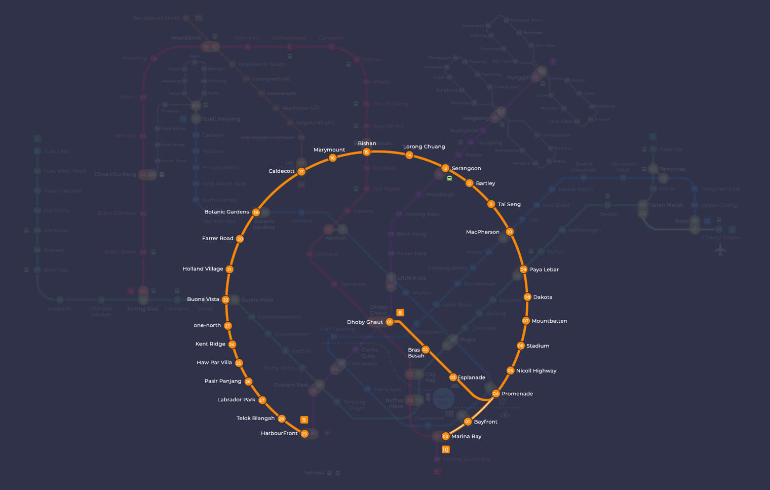
MacPherson station at a glance
| Station codes | CC10DT26 |
|---|---|
| Lines | Circle Line Downtown Line |
| Interchange | Yes, change between 2 lines here |
| Chinese name | 麦波申 |
| Tamil name | மெக்பர்சன் |
| Next stations | |
| Train times | Circle Line: first train leaves the terminus at 5:37 AM, last train 11:50 PM Downtown Line: first train leaves the terminus at 5:30 AM, last train 11:35 PM Full first and last train guide |
See MacPherson on the map. The interactive map opens with this station highlighted, so you can trace the route from where you are.
As an interchange station, MacPherson gives passengers direct access to two major lines across the network. On the Circle Line, the neighbouring stations are Paya Lebar to the east and Tai Seng to the west. On the Downtown Line, passengers can travel to Mattar in one direction and Ubi in the other. Paya Lebar itself is a further interchange with the East West Line, meaning a single change at that station opens up connections across much of the island.
The immediate area around MacPherson station is predominantly a quiet residential and light industrial district rather than a major commercial or tourist zone. Residents and workers in the MacPherson estate make up much of the foot traffic here, and the streets nearby are lined with coffee shops, provision stores, and small workshops typical of older Singapore neighbourhoods. Those looking for larger shopping or leisure facilities will generally find it more practical to travel one stop to Paya Lebar.
Around MacPherson station
MacPherson station sits within a largely residential neighbourhood made up of HDB estates, with Circuit Road Market and Food Centre and Circuit Road Hawker Centre serving the everyday needs of locals nearby. The area also offers recreational options, with Geylang East Swimming Complex within walking distance. Further out, Paya Lebar Square and SingPost Centre mark the edge of a commercial cluster accessible from the station.
| Place | Type | Distance | Why go |
|---|---|---|---|
| Circuit Road Market and Food Center | Food centre | About 330 m (~5 min walk) | Visit for a broad selection of local hawker food and fresh market produce. |
| 7 Stars Coffee Shop | Food centre | About 370 m (~6 min walk) | A neighbourhood coffee shop serving everyday local meals and drinks. |
| Circuit Road Hawker Centre | Food centre | About 500 m (~8 min walk) | Another hawker centre option with a range of cooked food stalls. |
| Geylang East Swimming Complex | Sports centre | About 570 m (~9 min walk) | Head here for swimming and general sports and recreational facilities. |
| Blk 117 Aljunied Ave 2 Market | Market / hawker centre | About 670 m (~11 min walk) | A local market and hawker centre serving the Aljunied Avenue 2 community. |
| Sri Sivan Temple | Place of worship | About 870 m (~14 min walk) | A Hindu temple worth visiting for its religious and cultural significance. |
| Paya Lebar Square | Shopping mall | About 890 m (~14 min walk) | A shopping mall with retail shops, dining, and everyday services. |
| SingPost Centre | Shopping mall | About 990 m (~16 min walk) | A combined mall and post office hub offering retail and postal services. |
Places and straight-line distances from OpenStreetMap data (© OpenStreetMap contributors). Actual walking routes may be longer.
How to get to MacPherson by MRT
Worked out from the network map. Stop counts are station to station and do not include walking or waiting time.
| From Changi Airport | Take the East West Line from Changi Airport to Paya Lebar (6 stops), then change to the Circle Line from Paya Lebar to MacPherson (1 stop). About 7 stops with 1 change. |
|---|---|
| From Orchard | Take the North South Line from Orchard to Bishan (5 stops), then change to the Circle Line from Bishan to MacPherson (5 stops). About 10 stops with 1 change. |
| From City Hall | Take the East West Line from City Hall to Paya Lebar (5 stops), then change to the Circle Line from Paya Lebar to MacPherson (1 stop). About 6 stops with 1 change. |
| From Jurong East | Take the East West Line from Jurong East to Buona Vista (3 stops), then change to the Circle Line from Buona Vista to MacPherson (11 stops). About 14 stops with 1 change. |
| From Woodlands | Take the North South Line from Woodlands to Bishan (8 stops), then change to the Circle Line from Bishan to MacPherson (5 stops). About 13 stops with 1 change. |
| From HarbourFront | Take the North East Line from HarbourFront to Chinatown (1 stop), then change to the Downtown Line from Chinatown to MacPherson (7 stops). About 8 stops with 1 change. |
Tips for using MacPherson station
- Circuit Road Market and Food Centre is the closest food option, at roughly five minutes on foot, making it a convenient first stop after alighting.
- Paya Lebar Square and SingPost Centre are both under a kilometre away but the walk takes around 14 to 16 minutes, so factor in extra time if the weather is poor.
- MacPherson is an interchange between the Circle Line and the Downtown Line, so plan your onward journey using whichever line best suits your destination.
- During morning and evening peak hours the station can be busy, particularly for commuters changing between the two lines, so allow a little extra time when transferring.
All stations on the Circle Line
In order along the line, with MacPherson marked. Stations with their own guide are linked.
| Code | Station | Interchange |
|---|---|---|
| CC2 | Bras Basah | – |
| CC3 | Esplanade | – |
| CC4 | Promenade | CC / DT |
| CC5 | Nicoll Highway | – |
| CC6 | Stadium | – |
| CC7 | Mountbatten | – |
| CC8 | Dakota | – |
| CC9 | Paya Lebar | CC / EW |
| CC10 | MacPherson (you are here) | CC / DT |
| CC11 | Tai Seng | – |
| CC12 | Bartley | – |
| CC13 | Serangoon | CC / NE |
| CC14 | Lorong Chuan | – |
| CC15 | Bishan | NS / CC |
| CC16 | Marymount | – |
| CC17 | Caldecott | CC / TE |
| CC19 | Botanic Gardens | DT / CC |
| CC20 | Farrer Road | – |
| CC21 | Holland Village | – |
| CC22 | Buona Vista | EW / CC |
| CC23 | one-north | – |
| CC24 | Kent Ridge | – |
| CC25 | Haw Par Villa | – |
| CC26 | Pasir Panjang | – |
| CC27 | Labrador Park | – |
| CC28 | Telok Blangah | – |
| CC29 | HarbourFront | CC / NE |
Read the full Circle Line guide.
All stations on the Downtown Line
In order along the line, with MacPherson marked. Stations with their own guide are linked.
| Code | Station | Interchange |
|---|---|---|
| DT1 | Bukit Panjang | DT / BP |
| DT2 | Cashew | – |
| DT3 | Hillview | – |
| DT5 | Beauty World | – |
| DT6 | King Albert Park | – |
| DT7 | Sixth Avenue | – |
| DT8 | Tan Kah Kee | – |
| DT9 | Botanic Gardens | DT / CC |
| DT10 | Stevens | DT / TE |
| DT11 | Newton | NS / DT |
| DT12 | Little India | DT / NE |
| DT13 | Rochor | – |
| DT14 | Bugis | DT / EW |
| DT15 | Promenade | CC / DT |
| DT16 | Bayfront | CE / DT |
| DT17 | Downtown | – |
| DT18 | Telok Ayer | – |
| DT19 | Chinatown | DT / NE |
| DT20 | Fort Canning | – |
| DT21 | Bencoolen | – |
| DT22 | Jalan Besar | – |
| DT23 | Bendemeer | – |
| DT24 | Geylang Bahru | – |
| DT25 | Mattar | – |
| DT26 | MacPherson (you are here) | CC / DT |
| DT27 | Ubi | – |
| DT28 | Kaki Bukit | – |
| DT29 | Bedok North | – |
| DT30 | Bedok Reservoir | – |
| DT31 | Tampines West | – |
| DT32 | Tampines | EW / DT |
| DT33 | Tampines East | – |
| DT34 | Upper Changi | – |
| DT35 | Expo | DT / CG |
Read the full Downtown Line guide.
MacPherson station: common questions
Which line is MacPherson MRT station on?
MacPherson is on the Circle Line and the Downtown Line. Its station codes are CC10 and DT26.
Is MacPherson an interchange station?
Yes. You can change between the Circle Line and the Downtown Line inside the station without leaving the paid area.
What time is the first and last train at MacPherson?
Times below are for the first and last train leaving the line terminus; trains reach MacPherson a few minutes later depending on its position on the line. Circle Line first train 5:37 AM, last train 11:50 PM. Downtown Line first train 5:30 AM, last train 11:35 PM. Check the operator for holiday changes.
What is near MacPherson MRT station?
The area around MacPherson station has several hawker centres and food options, including Circuit Road Market and Food Centre at approximately 330 metres and Circuit Road Hawker Centre at approximately 500 metres. There is also Geylang East Swimming Complex, Sri Sivan Temple, and the shopping malls Paya Lebar Square and SingPost Centre within roughly a kilometre.
Which food centre is closest to MacPherson MRT station?
Circuit Road Market and Food Centre is the closest, at approximately 330 metres straight-line distance, which is roughly a five-minute walk from the station.
How far is Paya Lebar Square from MacPherson MRT station?
Paya Lebar Square is approximately 890 metres away in a straight line from MacPherson station, which works out to roughly a 14-minute walk.
How do I get to MacPherson from Changi Airport by MRT?
Take the East West Line from Changi Airport to Paya Lebar (6 stops), then change to the Circle Line from Paya Lebar to MacPherson (1 stop). About 7 stops with 1 change.
Sources: station codes, line colours and interchanges from the LTA rail system map; operating hours from SMRT and SBS Transit. Last reviewed September 2026.
News and guides mentioning MacPherson
- Most Instagram-Worthy MRT Stations in Singapore 28 Sep 2026
- MRT Station Codes and Interchange Stations Explained 31 Aug 2026
Plan the rest of the trip
Every station on the Circle Line and the Downtown Line is listed on its line guide, with the full route and interchanges. For times, see the first and last train guide, and for the whole network in one view use the interactive Singapore MRT map or the PDF map.