
Marine Parade MRT Station
Marine Parade MRT station (TE26) is an underground station on the Thomson-East Coast Line, located beneath Marine Parade Road in the Marine Parade district of eastern Singapore. It sits close to the junction of Marine Parade Road and Joo Chiat Road, in the area where the older Katong and Joo Chiat neighbourhoods meet the housing estates of Marine Parade.
Marine Parade on the Thomson East Coast Line map
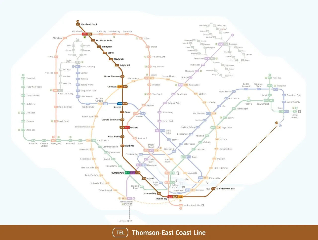
Marine Parade MRT station at a glance
| Station codes | TE26 |
|---|---|
| Lines | Thomson East Coast Line |
| Line colour | Brown line (Thomson East Coast Line) |
| Interchange | No, single line station |
| Chinese name | 马林百列 |
| Tamil name | மரீன் பரேட் |
| Opened | 23 June 2024 (2 years ago) |
| Operator | SMRT Trains |
| Station type | Underground |
| Platforms | 2 (1 island platform) |
| Address | 101 Marine Parade Road, Singapore 449971 |
| Next stations | |
| Train times | Thomson East Coast Line: first train leaves the terminus at 5:36 AM, last train 11:42 PM Full first and last train guide |
Opening date, operator and ridership figures are LTA data as recorded on Wikipedia.
See Marine Parade on the map. The interactive map opens with this station highlighted, so you can trace the route from where you are.
The station has six entrances spread around the surrounding streets. Most of its passengers are residents of the many private and public housing estates in Marine Parade, along with shoppers and diners heading to the malls and food centres around it. Landmarks within easy reach include Parkway Parade, Roxy Square, I12 Katong, Hotel Indigo Katong and the Marine Parade Community Building.
History of Marine Parade MRT station
The station opened to passengers on 23 June 2024 as part of the fourth stage of the Thomson-East Coast Line, after pandemic restrictions on construction pushed the opening back by a year. Two days before opening, Prime Minister Lawrence Wong and former prime minister Goh Chok Tong held the ceremony inaugurating the new stretch of line here. A covered linkway from the station to Parkway Parade has been under construction since December 2024 and is expected to be completed by 2027.
Inside Marine Parade MRT station
Trains stop at a single island platform, and the station also serves as a designated Civil Defence shelter. Cyclists are well served: Marine Parade MRT station was one of the first on the network to offer underground bicycle parking, with 364 lots, larger lifts from street level and stairs designed to make wheeling a bike up and down easier. Inside, green panels and star-shaped ceiling lights recall the area’s past as a seafront lined with trees.
Outside, look for WALK by Ang Sookoon, a 2.2 metre bronze sculpture shaped like a block of plasticine. The artist grew up in the neighbourhood and made the piece as a playful tribute to it. A mural by Mural Lingo also depicts local landmarks and the Chinese, Malay, Peranakan, Indian and Eurasian influences of the Katong and Joo Chiat community.
For most visitors, Marine Parade MRT station is the stop for shopping and eating. Roxy Square and Parkway Parade are both about a two minute walk away, and imall is only slightly further. For a meal, Marine Parade Food Centre and Marine Parade Market are around 150 metres from the station, with Kopitiam Food Hall and Guan Chee HK Roast close by as well. If you have more time, the Conserved Terrace Houses are roughly a six minute walk away and make a good start for exploring the older streets of Katong and Joo Chiat on foot.
Around Marine Parade MRT station
Marine Parade station sits in a mature residential and commercial neighbourhood along the East Coast, well served by shopping malls and local food options within easy walking distance. Parkway Parade and Roxy Square are both just a couple of minutes away on foot, making this a convenient stop for everyday errands and leisure. The area also retains some of its older character, with conserved terrace houses a short walk from the station.
| Place | Type | Distance | Why go |
|---|---|---|---|
| Roxy Square | Shopping mall | About 100 m (~2 min walk) | Visit Roxy Square for a neighbourhood shopping and dining experience. |
| Parkway Parade | Shopping mall | About 130 m (~2 min walk) | Head to Parkway Parade for a wide range of retail, dining and services. |
| Marine Parade Food Centre | Food centre | About 140 m (~2 min walk) | Marine Parade Food Centre is good for local hawker food and cooked dishes. |
| Guan Chee HK Roast | Food centre | About 140 m (~2 min walk) | Guan Chee HK Roast is a food stall known for roasted meat dishes. |
| Kopitiam Food Hall | Food centre | About 150 m (~2 min walk) | Kopitiam Food Hall offers a variety of local food court options. |
| Marine Parade Market | Market / hawker centre | About 150 m (~2 min walk) | Marine Parade Market is a good spot for fresh produce and local fare. |
| imall | Shopping mall | About 190 m (~3 min walk) | imall provides additional shopping and lifestyle options nearby. |
| Conserved Terrace Houses | Attraction | About 380 m (~6 min walk) | The conserved terrace houses are worth a look for their heritage architecture. |
Places and straight-line distances from OpenStreetMap data (© OpenStreetMap contributors). Actual walking routes may be longer.
How to get to Marine Parade by MRT
Worked out from the network map. Stop counts are station to station and do not include walking or waiting time.
| From Changi Airport | Take the East West Line from Changi Airport to Raffles Place (12 stops), then change to the North South Line from Raffles Place to Marina Bay (1 stop), then change to the Thomson East Coast Line from Marina Bay to Marine Parade (5 stops). About 18 stops with 2 changes. |
|---|---|
| From Orchard | Take the Thomson East Coast Line from Orchard to Marine Parade (11 stops). About 11 stops, no changes. |
| From City Hall | Take the North South Line from City Hall to Marina Bay (2 stops), then change to the Thomson East Coast Line from Marina Bay to Marine Parade (5 stops). About 7 stops with 1 change. |
| From Jurong East | Take the East West Line from Jurong East to Outram Park (8 stops), then change to the Thomson East Coast Line from Outram Park to Marine Parade (8 stops). About 16 stops with 1 change. |
| From Woodlands | Take the Thomson East Coast Line from Woodlands to Marine Parade (22 stops). About 22 stops, no changes. |
| From HarbourFront | Take the Circle Line from HarbourFront to Marina Bay (4 stops), then change to the Thomson East Coast Line from Marina Bay to Marine Parade (5 stops). About 9 stops with 1 change. |
Fares from Marine Parade MRT station
A trip from Marine Parade to Changi Airport (about 29 km) costs S$2.46 on an adult SimplyGo or EZ-Link card. Fares are charged by distance, so the table below shows the estimated adult card fare from Marine Parade to the main hubs, the early bird fare for journeys that start before 7.45am on weekdays, and the fare that applies from 26 December 2026.
| To | Distance | Adult card | Before 7.45am | From 26 Dec 2026 |
|---|---|---|---|---|
| Changi Airport | about 29 km, 18 stops | S$2.46 | S$1.96 | S$2.59 |
| Orchard | about 13 km, 11 stops | S$1.98 | S$1.48 | S$2.11 |
| City Hall | about 10 km, 7 stops | S$1.86 | S$1.36 | S$1.99 |
| Raffles Place | about 9 km, 6 stops | S$1.82 | S$1.32 | S$1.95 |
| Jurong East | about 24 km, 16 stops | S$2.38 | S$1.88 | S$2.51 |
| Woodlands | about 34 km, 22 stops | S$2.50 | S$2.00 | S$2.63 |
| HarbourFront | about 13 km, 9 stops | S$1.98 | S$1.48 | S$2.11 |
| Marina Bay | about 8 km, 5 stops | S$1.75 | S$1.25 | S$1.88 |
Estimated from the route distance between stations and the Public Transport Council fare table in force from 27 December 2025. The exact fare can differ by one band. Cash fares are higher. Use the fare calculator for any other journey, or check your fare on the SimplyGo app.
Tips for using Marine Parade MRT station
- Most destinations on the verified list are within a short walk of the station, so arriving on foot is straightforward for all of them.
- Marine Parade is a busy area, particularly around the malls and food centres during lunch and weekend afternoons, so allow a little extra time if visiting then.
- The conserved terrace houses are approximately 380 metres away, which is a longer walk compared to the other nearby places, so factor in around six minutes on foot.
- Marine Parade station is on the Thomson East Coast Line only, so plan any onward journeys that require a different line to include an interchange at another station.
All stations on the Thomson East Coast Line
In order along the line, with Marine Parade marked. Stations with their own guide are linked.
| Code | Station | Interchange |
|---|---|---|
| TE1 | Woodlands North | None |
| TE2 | Woodlands | NS / TE |
| TE3 | Woodlands South | None |
| TE4 | Springleaf | None |
| TE5 | Lentor | None |
| TE6 | Mayflower | None |
| TE7 | Bright Hill | None |
| TE8 | Upper Thomson | None |
| TE9 | Caldecott | CC / TE |
| TE11 | Stevens | DT / TE |
| TE12 | Napier | None |
| TE13 | Orchard Boulevard | None |
| TE14 | Orchard | TE / NS |
| TE15 | Great World | None |
| TE16 | Havelock | None |
| TE17 | Outram Park | TE / EW / NE |
| TE18 | Maxwell | None |
| TE19 | Shenton Way | None |
| TE20 | Marina Bay | CE / TE / NS |
| TE22 | Gardens by the Bay | None |
| TE23 | Tanjong Rhu | None |
| TE24 | Katong Park | None |
| TE25 | Tanjong Katong | None |
| TE26 | Marine Parade (you are here) | None |
| TE27 | Marine Terrace | None |
| TE28 | Siglap | None |
| TE29 | Bayshore | None |
Read the full Thomson East Coast Line guide.
Marine Parade MRT station: common questions
Which line is Marine Parade MRT station on?
Marine Parade is on the Thomson East Coast Line. Its station code is TE26.
Is Marine Parade an interchange station?
No. Marine Parade is served by the Thomson East Coast Line only. The nearest interchange is shown in the next stations row above.
What time is the first and last train at Marine Parade?
Times below are for the first and last train leaving the line terminus; trains reach Marine Parade a few minutes later depending on its position on the line. Thomson East Coast Line first train 5:36 AM, last train 11:42 PM. Check the operator for holiday changes.
What is near Marine Parade MRT station?
The station is close to several shopping malls including Roxy Square and Parkway Parade, multiple food options such as Marine Parade Food Centre and Kopitiam Food Hall, and the Marine Parade Market. Conserved terrace houses are also within walking distance at approximately 380 metres.
Which mall or food centre is closest to Marine Parade MRT station?
Roxy Square is the closest mall at approximately 100 metres, while Marine Parade Food Centre and Guan Chee HK Roast are among the nearest food options at approximately 140 metres, all roughly a two-minute walk.
How far is Parkway Parade from Marine Parade MRT station?
Parkway Parade is approximately 130 metres from the station in a straight line, which works out to roughly a two-minute walk.
How do I get to Marine Parade from Changi Airport by MRT?
Take the East West Line from Changi Airport to Raffles Place (12 stops), then change to the North South Line from Raffles Place to Marina Bay (1 stop), then change to the Thomson East Coast Line from Marina Bay to Marine Parade (5 stops). About 18 stops with 2 changes.
Sources: station codes, line colours and interchanges from the LTA rail system map; operating hours from SMRT and SBS Transit. Last reviewed October 2026.
News and guides mentioning Marine Parade
- Johor-Singapore RTS Link gets 5G: What it means for cross-border riders 6 Nov 2026
- シンガポール地下鉄(MRT)路線図 2026(日本語ガイド) 4 Oct 2026
- Bus & Train Fares Rise Up to 13 Cents from Dec 26 30 Sep 2026
- Singapore Expands Metro Network with State-of-the-Art Signalling 23 Aug 2026
Plan the rest of the trip
Every station on the Thomson-East Coast Line is listed on its line guide, with the full route and interchanges. For times, see the first and last train guide, and for the whole network in one view use the interactive Singapore MRT map or the PDF map.
Exits and buses at Marine Parade station
Marine Parade has 3 mapped exits (1 to 3). The numbers match the signs inside the station; the landmark beside each one is the closest mapped place to that entrance, so pick the exit that comes up nearest to where you are going.
- Exit 1: closest to Marine Parade Food Centre (about 58 m from the entrance)
- Exit 2: closest to Roxy Square (about 72 m from the entrance)
- Exit 3: closest to imall (about 75 m from the entrance)
Bus stops within 250 m of Marine Parade station
| Bus stop | Stop code | Services | From station |
|---|---|---|---|
| Marine Parade Station Exit 2 | 92041 | 15, 31, 36, 36B, 43, 43e, 48, 134, 135, 196, 196e, 197, 853M, 966, 966A | 17 m |
| Marine Parade Station/Parkway Parade | 92049 | 15, 31, 36, 36A, 36B, 43, 43e, 47, 48, 134, 135, 196, 196A, 196e, 197, 401, 853M, 966, 966A | 118 m |
Exits and bus services come from OpenStreetMap and can change when roads or routes are revised; check the board at the stop or the operator app before relying on a service late at night. For the nearest station to where you are now, use the MRT near me finder.
Places to visit from Marine Parade station
Step-by-step guides with the exit to use, the walk and the fare:
See every guide on how to get to Singapore's attractions, hospitals and malls by MRT, with routes and fares from Changi Airport, Orchard and the city.
Hungry? See food near Marine Parade MRT: hawker centres, food courts and cafes with walking times.