
Bright Hill MRT Station
Bright Hill MRT station is an underground station on the Thomson-East Coast Line, where it carries the code TE7. It sits beneath Sin Ming Avenue on the western side of Bishan, and its platforms lie around 20 metres below the street. Four entrances lead down to the station from the surrounding roads.
Bright Hill on the Thomson East Coast Line map
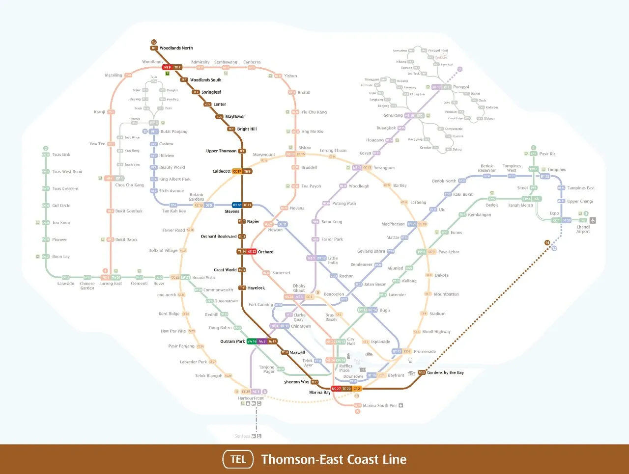
Bright Hill MRT station at a glance
| Station codes | TE7 |
|---|---|
| Lines | Thomson East Coast Line |
| Line colour | Brown line (Thomson East Coast Line) |
| Interchange | No, single line station |
| Chinese name | 光明山 |
| Tamil name | பிரைட் ஹில் |
| Opened | 28 August 2021 (5 years ago) |
| Operator | SMRT Trains |
| Station type | Underground |
| Platforms | 2 (1 island platform) |
| Address | 100 Sin Ming Avenue, Singapore 575737 |
| Daily ridership | About 5,284 passengers a day (2024) |
| Next stations | |
| Train times | Thomson East Coast Line: first train leaves the terminus at 5:36 AM, last train 11:42 PM Full first and last train guide |
Opening date, operator and ridership figures are LTA data as recorded on Wikipedia.
See Bright Hill on the map. The interactive map opens with this station highlighted, so you can trace the route from where you are.
The station mainly serves the residential estates around Sin Ming Avenue, so many of its passengers are local residents making daily journeys to work, school and the shops. Students also use it to reach schools in the area such as Ai Tong School, Peirce Secondary School and Eunoia Junior College. Visitors heading to Kong Meng San Phor Kark See Monastery or Bishan-Ang Mo Kio Park make up another regular group, since both are a short walk from the station.
History of Bright Hill MRT station
When plans for the line were first revealed in 2012, the station carried the working name Sin Ming. It opened to passengers on 28 August 2021, together with the other stations in the second phase of the Thomson-East Coast Line, after the opening date slipped because of pandemic restrictions and a review of the line’s rail software. Bright Hill is set to become an interchange, as it will be the terminus of the first phase of the Cross Island Line, which is expected to be completed in 2030. As part of that work, Sin Ming Avenue is planned to become a Transit Priority Corridor with new bus lanes and cycling paths.
Inside Bright Hill MRT station
The station is designated as a Civil Defence shelter. Its reinforced structure and blast doors allow it to hold up to 6,000 people in an emergency. Above the platforms, the roof has a wave-like pattern that refers to the nearby Kallang River. Gaps in the ceiling echo crown shyness, the natural pattern in which the tops of neighbouring trees avoid touching. An Art-in-Transit work by Angie Seah decorates the lift shaft, with colours and patterns drawn from plants in the nearby park.
For most people, Bright Hill MRT station is the stop for the area’s religious and green spaces. Kong Meng San Phor Kark See Monastery is about four minutes away on foot, and the Buddhist College of Singapore is even closer. Bishan-Ang Mo Kio Park is also roughly four minutes from the station, which makes it a practical starting point for a walk, jog or cycle along the park’s paths. For everyday meals and groceries, Kebun Baru Market is about ten minutes’ walk away. Thomson Plaza is a longer walk of around 17 minutes for anyone who wants a shopping mall.
Around Bright Hill MRT station
Bright Hill station sits in a quiet, predominantly residential part of northern Singapore, bordered by greenery and places of worship. The Kong Meng San Phor Kark See Monastery and the Buddhist College of Singapore give the immediate surroundings a calm, contemplative character. Bishan-Ang Mo Kio Park lies close by, making this a popular area for those seeking nature and recreation.
| Place | Type | Distance | Why go |
|---|---|---|---|
| Buddhist College of Singapore | College | About 160 m (~3 min walk) | Visit for Buddhist education programmes and a respected academic institution. |
| Kong Meng San Phor Kark See Monastery | Place of worship | About 260 m (~4 min walk) | A large monastery complex worth visiting for worship, reflection and Chinese Buddhist architecture. |
| Bishan-Ang Mo Kio Park | Park | About 260 m (~4 min walk) | A spacious park popular for walking, cycling and enjoying the river landscape. |
| NTUC Foodfare | Food centre | About 620 m (~10 min walk) | A convenient food centre offering a range of cooked food options for a quick meal. |
| AMK 232 Foodhouse | Food centre | About 620 m (~10 min walk) | Another nearby food centre with a variety of local dishes to choose from. |
| Kebun Baru Market | Market / hawker centre | About 640 m (~10 min walk) | A neighbourhood market and hawker centre good for local food and fresh produce. |
| Eunoia Junior College | College | About 660 m (~11 min walk) | A junior college serving pre-university students in the surrounding area. |
| Thomson Plaza | Shopping mall | About 1040 m (~17 min walk) | A neighbourhood shopping mall with retail shops and dining options. |
Places and straight-line distances from OpenStreetMap data (© OpenStreetMap contributors). Actual walking routes may be longer.
How to get to Bright Hill by MRT
Worked out from the network map. Stop counts are station to station and do not include walking or waiting time.
| From Changi Airport | Take the East West Line from Changi Airport to Paya Lebar (6 stops), then change to the Circle Line from Paya Lebar to Caldecott (8 stops), then change to the Thomson East Coast Line from Caldecott to Bright Hill (2 stops). About 16 stops with 2 changes. |
|---|---|
| From Orchard | Take the Thomson East Coast Line from Orchard to Bright Hill (6 stops). About 6 stops, no changes. |
| From City Hall | Take the North South Line from City Hall to Orchard (3 stops), then change to the Thomson East Coast Line from Orchard to Bright Hill (6 stops). About 9 stops with 1 change. |
| From Jurong East | Take the North South Line from Jurong East to Woodlands (7 stops), then change to the Thomson East Coast Line from Woodlands to Bright Hill (5 stops). About 12 stops with 1 change. |
| From Woodlands | Take the Thomson East Coast Line from Woodlands to Bright Hill (5 stops). About 5 stops, no changes. |
| From HarbourFront | Take the North East Line from HarbourFront to Outram Park (1 stop), then change to the Thomson East Coast Line from Outram Park to Bright Hill (9 stops). About 10 stops with 1 change. |
Fares from Bright Hill MRT station
A trip from Bright Hill to Changi Airport (about 27 km) costs S$2.43 on an adult SimplyGo or EZ-Link card. Fares are charged by distance, so the table below shows the estimated adult card fare from Bright Hill to the main hubs, the early bird fare for journeys that start before 7.45am on weekdays, and the fare that applies from 26 December 2026.
| To | Distance | Adult card | Before 7.45am | From 26 Dec 2026 |
|---|---|---|---|---|
| Changi Airport | about 27 km, 16 stops | S$2.43 | S$1.93 | S$2.56 |
| Orchard | about 10 km, 6 stops | S$1.86 | S$1.36 | S$1.99 |
| City Hall | about 13 km, 9 stops | S$1.98 | S$1.48 | S$2.11 |
| Raffles Place | about 14 km, 10 stops | S$2.02 | S$1.52 | S$2.15 |
| Jurong East | about 27 km, 12 stops | S$2.43 | S$1.93 | S$2.56 |
| Woodlands | about 11 km, 5 stops | S$1.94 | S$1.44 | S$2.07 |
| HarbourFront | about 15 km, 10 stops | S$2.11 | S$1.61 | S$2.24 |
| Marina Bay | about 15 km, 12 stops | S$2.07 | S$1.57 | S$2.20 |
Estimated from the route distance between stations and the Public Transport Council fare table in force from 27 December 2025. The exact fare can differ by one band. Cash fares are higher. Use the fare calculator for any other journey, or check your fare on the SimplyGo app.
Tips for using Bright Hill MRT station
- The Buddhist College of Singapore and Kong Meng San Phor Kark See Monastery are both within a short, comfortable walk from the station, making them easy to visit on foot.
- Bishan-Ang Mo Kio Park is also within walking distance, but wear comfortable shoes as the park grounds are extensive once you are inside.
- The food centres and Kebun Baru Market are roughly a ten-minute walk away; consider taking a bus if the weather is hot or if you prefer a quicker journey.
- Thomson Plaza is over a kilometre away and is more comfortably reached by bus rather than on foot, especially when carrying shopping.
All stations on the Thomson East Coast Line
In order along the line, with Bright Hill marked. Stations with their own guide are linked.
| Code | Station | Interchange |
|---|---|---|
| TE1 | Woodlands North | None |
| TE2 | Woodlands | NS / TE |
| TE3 | Woodlands South | None |
| TE4 | Springleaf | None |
| TE5 | Lentor | None |
| TE6 | Mayflower | None |
| TE7 | Bright Hill (you are here) | None |
| TE8 | Upper Thomson | None |
| TE9 | Caldecott | CC / TE |
| TE11 | Stevens | DT / TE |
| TE12 | Napier | None |
| TE13 | Orchard Boulevard | None |
| TE14 | Orchard | TE / NS |
| TE15 | Great World | None |
| TE16 | Havelock | None |
| TE17 | Outram Park | TE / EW / NE |
| TE18 | Maxwell | None |
| TE19 | Shenton Way | None |
| TE20 | Marina Bay | CE / TE / NS |
| TE22 | Gardens by the Bay | None |
| TE23 | Tanjong Rhu | None |
| TE24 | Katong Park | None |
| TE25 | Tanjong Katong | None |
| TE26 | Marine Parade | None |
| TE27 | Marine Terrace | None |
| TE28 | Siglap | None |
| TE29 | Bayshore | None |
Read the full Thomson East Coast Line guide.
Bright Hill MRT station: common questions
Which line is Bright Hill MRT station on?
Bright Hill is on the Thomson East Coast Line. Its station code is TE7.
Is Bright Hill an interchange station?
No. Bright Hill is served by the Thomson East Coast Line only. The nearest interchange is shown in the next stations row above.
What time is the first and last train at Bright Hill?
Times below are for the first and last train leaving the line terminus; trains reach Bright Hill a few minutes later depending on its position on the line. Thomson East Coast Line first train 5:36 AM, last train 11:42 PM. Check the operator for holiday changes.
What is near Bright Hill MRT station?
The closest places include the Buddhist College of Singapore at roughly 160 m, Kong Meng San Phor Kark See Monastery and Bishan-Ang Mo Kio Park both at approximately 260 m, and several food centres and a market within about 620 to 640 m.
Which shopping mall is closest to Bright Hill station?
Thomson Plaza is the nearest shopping mall, located approximately 1,040 m from the station, which is around a 17-minute walk.
How far is Bishan-Ang Mo Kio Park from Bright Hill station?
Bishan-Ang Mo Kio Park is approximately 260 m from the station, which is roughly a 4-minute walk.
How do I get to Bright Hill from Changi Airport by MRT?
Take the East West Line from Changi Airport to Paya Lebar (6 stops), then change to the Circle Line from Paya Lebar to Caldecott (8 stops), then change to the Thomson East Coast Line from Caldecott to Bright Hill (2 stops). About 16 stops with 2 changes.
Sources: station codes, line colours and interchanges from the LTA rail system map; operating hours from SMRT and SBS Transit. Last reviewed October 2026.
News and guides mentioning Bright Hill
- Ang Mo Kio Ave 3 traffic diversion: what commuters need to know 6 Nov 2026
- Johor-Singapore RTS Link gets 5G: What it means for cross-border riders 6 Nov 2026
- Singapore MRT history: from 5 stations in 1987 to 130+ today 6 Nov 2026
- Guangzhou Metro Expertise Comes to S’pore: What It Means 1 Nov 2026
Plan the rest of the trip
Every station on the Thomson-East Coast Line is listed on its line guide, with the full route and interchanges. For times, see the first and last train guide, and for the whole network in one view use the interactive Singapore MRT map or the PDF map.
Exits and buses at Bright Hill station
Bright Hill has 4 mapped exits (1 to 4). The numbers match the signs inside the station; the landmark beside each one is the closest mapped place to that entrance, so pick the exit that comes up nearest to where you are going.
- Exit 1
- Exit 2
- Exit 3
- Exit 4
Bus stops within 250 m of Bright Hill station
| Bus stop | Stop code | Services | From station |
|---|---|---|---|
| Bright Hill Station Exit 1 | 53349 | 52, 162, 162M, 410, 410G | 106 m |
| Bright Hill Station Exit 2 | 53341 | 52, 162, 162M, 410, 410W | 106 m |
| Before Bright Hill Temple | 53331 | 52, 162, 162M, 410, 410W | 218 m |
| Opposite Bright Hill Temple | 53339 | 52, 162, 162M, 410, 410G | 241 m |
Exits and bus services come from OpenStreetMap and can change when roads or routes are revised; check the board at the stop or the operator app before relying on a service late at night. For the nearest station to where you are now, use the MRT near me finder.
Places to visit from Bright Hill station
See every guide on how to get to Singapore's attractions, hospitals and malls by MRT, with routes and fares from Changi Airport, Orchard and the city.