
Siglap MRT Station
Siglap MRT station is an underground stop on the Thomson-East Coast Line, with the station code TE28. It lies along Marine Parade Road in Siglap, a largely residential district in the east of Singapore, within walking distance of several schools and the coast.
Siglap on the Thomson East Coast Line map
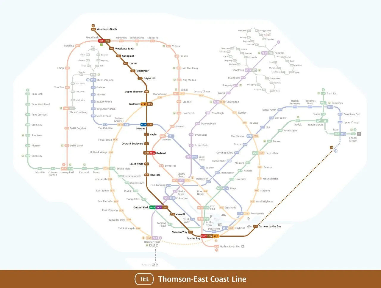
Siglap MRT station at a glance
| Station codes | TE28 |
|---|---|
| Lines | Thomson East Coast Line |
| Line colour | Brown line (Thomson East Coast Line) |
| Interchange | No, single line station |
| Chinese name | 实乞纳 |
| Tamil name | சிக்லாப் |
| Opened | 23 June 2024 (2 years ago) |
| Operator | SMRT Trains |
| Station type | Underground |
| Platforms | 2 (1 island platform) |
| Address | 1000 Marine Parade Road, Singapore 449969 |
| Next stations | |
| Train times | Thomson East Coast Line: first train leaves the terminus at 5:36 AM, last train 11:42 PM Full first and last train guide |
Opening date, operator and ridership figures are LTA data as recorded on Wikipedia.
See Siglap on the map. The interactive map opens with this station highlighted, so you can trace the route from where you are.
Much of the daily traffic comes from students and staff of Victoria School and St. Andrew’s Autism Centre and School, both close to the station, along with people who live nearby. The station is also a convenient stop for anyone heading to Area E of East Coast Park, which includes the East Coast Seafood Centre and Singapore Wake Park. Four exits spread the station’s reach around Marine Parade Road, and two drop-off points serve passengers arriving by car or taxi. Other landmarks within reach include Masjid Kampung Siglap, Sekolah Indonesia and Wisma Mendaki.
History of Siglap MRT station
The station was first announced in August 2014 as one of the stops planned for the eastern section of the line. Its name was settled after a public poll in October 2015, in which “Siglap South” was also put forward. Delays linked to the COVID-19 pandemic pushed the opening back by a year, and the station finally welcomed passengers on 23 June 2024 together with the rest of Stage 4, two days after a public open house.
Inside Siglap MRT station
The station is wheelchair accessible and has a single island platform, so trains in both directions stop on either side of the same platform. A motif of modular cubes runs from the exits, where it brings in natural light, down to the platforms, and a green roof echoes the nearby Siglap Linear Park.
Siglap is also designated as a Civil Defence shelter. Two artworks are on display: The Darkness which Reveals by Melissa Tan, made of layered steel and inspired by the name Siglap, which comes from the Malay word gelap (dark), and Journey Across Sunlight: A Siglap Mosaic by Brian Gothong Tan, a glass mosaic commissioned by Victoria School alumni.
For many visitors, Siglap MRT station is a practical rail stop for a day by the sea. East Coast Park (Zone E) is about 10 minutes away on foot, and East Coast Lagoon Food Centre is roughly 12 minutes’ walk, making it an easy place to eat after time at the beach. Closer to the station, Siglap Park is around 3 minutes away, while Siglap South Community Centre, about 7 minutes on foot, serves the local community. Students at Victoria School have one of the shortest walks of all, at roughly 3 minutes from the station.
Around Siglap MRT station
Siglap MRT station sits within a quiet, established residential neighbourhood along the eastern coast of Singapore. The area is well served by green spaces, with Siglap Park and East Coast Park nearby, making it popular with families and outdoor enthusiasts. Educational and community facilities such as Victoria School and Siglap South Community Centre also serve the surrounding community.
| Place | Type | Distance | Why go |
|---|---|---|---|
| Siglap Park | Park | About 180 m (~3 min walk) | A local park suitable for a quiet stroll or outdoor leisure. |
| Victoria School | College | About 210 m (~3 min walk) | A secondary school serving students in the eastern region. |
| Siglap South Community Centre | Community club | About 440 m (~7 min walk) | A community facility offering programmes and activities for residents. |
| East Coast Terrace Park | Park | About 540 m (~9 min walk) | A park with open grounds for relaxation and recreational activities. |
| East Coast Park (Zone E) | Park | About 600 m (~10 min walk) | A large seaside park popular for cycling, picnicking and waterside activities. |
| 3838 Eating Place | Food centre | About 710 m (~12 min walk) | A casual dining spot with a range of local food options. |
| St. Andrew's Community Hospital (Bedok) | Hospital | About 730 m (~12 min walk) | A community hospital providing step-down and rehabilitation care. |
| East Coast lagoon food centre | Food centre | About 740 m (~12 min walk) | A popular hawker centre by the coast offering a variety of local dishes. |
Places and straight-line distances from OpenStreetMap data (© OpenStreetMap contributors). Actual walking routes may be longer.
How to get to Siglap by MRT
Worked out from the network map. Stop counts are station to station and do not include walking or waiting time.
| From Changi Airport | Take the East West Line from Changi Airport to Raffles Place (12 stops), then change to the North South Line from Raffles Place to Marina Bay (1 stop), then change to the Thomson East Coast Line from Marina Bay to Siglap (7 stops). About 20 stops with 2 changes. |
|---|---|
| From Orchard | Take the Thomson East Coast Line from Orchard to Siglap (13 stops). About 13 stops, no changes. |
| From City Hall | Take the North South Line from City Hall to Marina Bay (2 stops), then change to the Thomson East Coast Line from Marina Bay to Siglap (7 stops). About 9 stops with 1 change. |
| From Jurong East | Take the East West Line from Jurong East to Outram Park (8 stops), then change to the Thomson East Coast Line from Outram Park to Siglap (10 stops). About 18 stops with 1 change. |
| From Woodlands | Take the Thomson East Coast Line from Woodlands to Siglap (24 stops). About 24 stops, no changes. |
| From HarbourFront | Take the Circle Line from HarbourFront to Marina Bay (4 stops), then change to the Thomson East Coast Line from Marina Bay to Siglap (7 stops). About 11 stops with 1 change. |
Fares from Siglap MRT station
A trip from Siglap to Changi Airport (about 32 km) costs S$2.49 on an adult SimplyGo or EZ-Link card. Fares are charged by distance, so the table below shows the estimated adult card fare from Siglap to the main hubs, the early bird fare for journeys that start before 7.45am on weekdays, and the fare that applies from 26 December 2026.
| To | Distance | Adult card | Before 7.45am | From 26 Dec 2026 |
|---|---|---|---|---|
| Changi Airport | about 32 km, 20 stops | S$2.49 | S$1.99 | S$2.62 |
| Orchard | about 16 km, 13 stops | S$2.11 | S$1.61 | S$2.24 |
| City Hall | about 13 km, 9 stops | S$1.98 | S$1.48 | S$2.11 |
| Raffles Place | about 12 km, 8 stops | S$1.94 | S$1.44 | S$2.07 |
| Jurong East | about 27 km, 18 stops | S$2.43 | S$1.93 | S$2.56 |
| Woodlands | about 37 km, 24 stops | S$2.53 | S$2.03 | S$2.66 |
| HarbourFront | about 16 km, 11 stops | S$2.11 | S$1.61 | S$2.24 |
| Marina Bay | about 11 km, 7 stops | S$1.90 | S$1.40 | S$2.03 |
Estimated from the route distance between stations and the Public Transport Council fare table in force from 27 December 2025. The exact fare can differ by one band. Cash fares are higher. Use the fare calculator for any other journey, or check your fare on the SimplyGo app.
Tips for using Siglap MRT station
- Siglap Park and Victoria School are both within a comfortable short walk of the station, so no onward transport is needed to reach them.
- East Coast Park and the food centres along the coast are roughly 10 to 12 minutes on foot, but taking a connecting bus may be more practical during hot weather or if you are carrying heavy bags.
- During morning and evening peak hours, trains on the Thomson East Coast Line can be busy, so allow a little extra time if you have a fixed appointment at St. Andrew's Community Hospital or elsewhere.
- If you are heading to multiple destinations in the area such as East Coast Lagoon Food Centre and East Coast Park, plan your route from the station in one direction to avoid unnecessary backtracking.
All stations on the Thomson East Coast Line
In order along the line, with Siglap marked. Stations with their own guide are linked.
| Code | Station | Interchange |
|---|---|---|
| TE1 | Woodlands North | None |
| TE2 | Woodlands | NS / TE |
| TE3 | Woodlands South | None |
| TE4 | Springleaf | None |
| TE5 | Lentor | None |
| TE6 | Mayflower | None |
| TE7 | Bright Hill | None |
| TE8 | Upper Thomson | None |
| TE9 | Caldecott | CC / TE |
| TE11 | Stevens | DT / TE |
| TE12 | Napier | None |
| TE13 | Orchard Boulevard | None |
| TE14 | Orchard | TE / NS |
| TE15 | Great World | None |
| TE16 | Havelock | None |
| TE17 | Outram Park | TE / EW / NE |
| TE18 | Maxwell | None |
| TE19 | Shenton Way | None |
| TE20 | Marina Bay | CE / TE / NS |
| TE22 | Gardens by the Bay | None |
| TE23 | Tanjong Rhu | None |
| TE24 | Katong Park | None |
| TE25 | Tanjong Katong | None |
| TE26 | Marine Parade | None |
| TE27 | Marine Terrace | None |
| TE28 | Siglap (you are here) | None |
| TE29 | Bayshore | None |
Read the full Thomson East Coast Line guide.
Siglap MRT station: common questions
Which line is Siglap MRT station on?
Siglap is on the Thomson East Coast Line. Its station code is TE28.
Is Siglap an interchange station?
No. Siglap is served by the Thomson East Coast Line only. The nearest interchange is shown in the next stations row above.
What time is the first and last train at Siglap?
Times below are for the first and last train leaving the line terminus; trains reach Siglap a few minutes later depending on its position on the line. Thomson East Coast Line first train 5:36 AM, last train 11:42 PM. Check the operator for holiday changes.
What is near Siglap MRT station?
The station is close to Siglap Park, Victoria School and Siglap South Community Centre, as well as East Coast Park and several food centres along the coast. St. Andrew's Community Hospital is also approximately 730 metres away.
Which food centre is closest to Siglap MRT station?
3838 Eating Place is the nearest food centre at approximately 710 metres away, roughly a 12-minute walk. East Coast Lagoon Food Centre is also nearby at approximately 740 metres.
How far is East Coast Park from Siglap MRT station?
East Coast Park (Zone E) is approximately 600 metres from the station, which is roughly a 10-minute walk.
How do I get to Siglap from Changi Airport by MRT?
Take the East West Line from Changi Airport to Raffles Place (12 stops), then change to the North South Line from Raffles Place to Marina Bay (1 stop), then change to the Thomson East Coast Line from Marina Bay to Siglap (7 stops). About 20 stops with 2 changes.
Sources: station codes, line colours and interchanges from the LTA rail system map; operating hours from SMRT and SBS Transit. Last reviewed October 2026.
News and guides mentioning Siglap
- Johor-Singapore RTS Link gets 5G: What it means for cross-border riders 6 Nov 2026
- シンガポール地下鉄(MRT)路線図 2026(日本語ガイド) 4 Oct 2026
- MRT Map Singapore 2026: What Is New Since 2024 16 Aug 2024
- Thomson-East Coast Line 11 Aug 2023
Plan the rest of the trip
Every station on the Thomson-East Coast Line is listed on its line guide, with the full route and interchanges. For times, see the first and last train guide, and for the whole network in one view use the interactive Singapore MRT map or the PDF map.
Exits and buses at Siglap station
Siglap has 4 mapped exits (1 to 4). The numbers match the signs inside the station; the landmark beside each one is the closest mapped place to that entrance, so pick the exit that comes up nearest to where you are going.
- Exit 1
- Exit 2
- Exit 3
- Exit 4
Bus stops within 250 m of Siglap station
| Bus stop | Stop code | Services | From station |
|---|---|---|---|
| Siglap Station/Opposite Victoria School | 93031 | 4N, 31, 43, 47, 48, 55, 155, 196, 196e, 197, 853M | 14 m |
| Siglap Station/Laguna Park | 93039 | 31, 36, 36A, 36B, 43, 47, 48, 55, 155, 196, 196A, 196e, 197, 401, 853M | 74 m |
| Victoria School | 93201 | 31, 36, 36A, 36B, 43, 47, 48, 55, 155, 196, 196A, 196e, 197, 401, 853M | 124 m |
Exits and bus services come from OpenStreetMap and can change when roads or routes are revised; check the board at the stop or the operator app before relying on a service late at night. For the nearest station to where you are now, use the MRT near me finder.
Places to visit from Siglap station
Step-by-step guides with the exit to use, the walk and the fare:
See every guide on how to get to Singapore's attractions, hospitals and malls by MRT, with routes and fares from Changi Airport, Orchard and the city.