
City Hall MRT Station
City Hall MRT station is an underground interchange in Singapore’s Downtown Core, located beneath Stamford Road close to its junctions with North Bridge Road and St Andrew’s Road. It is served by two of the oldest lines on the network: the East West Line, where its code is EW13, and the North South Line, where its code is NS25.
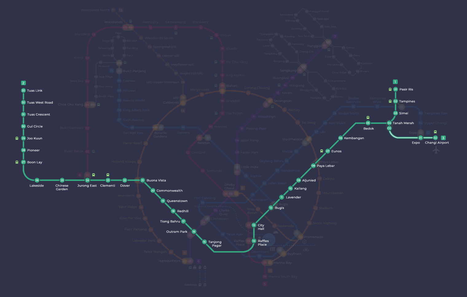
City Hall on the East West Line map
City Hall MRT station at a glance
| Station codes | EW13NS25 |
|---|---|
| Lines | East West Line North South Line |
| Line colour | Green line (East West Line) Red line (North South Line) |
| Interchange | Yes, change between 2 lines here |
| Chinese name | 政府大厦 |
| Tamil name | நகர மண்டபம் |
| Opened | 12 December 1987 (38 years ago) |
| Operator | SMRT Trains |
| Station type | Underground |
| Platforms | 4 (2 island platforms) |
| Address | 150 North Bridge RoadSingapore 179100 |
| Daily ridership | About 42,420 passengers a day (2023) |
| Next stations | |
| Train times | East West Line: first train leaves the terminus at 5:19 AM, last train 11:23 PM North South Line: first train leaves the terminus at 5:16 AM, last train 11:48 PM Full first and last train guide |
Opening date, operator and ridership figures are LTA data as recorded on Wikipedia.
See City Hall on the map. The interactive map opens with this station highlighted, so you can trace the route from where you are.
Because both lines stop here, a large share of passengers use the station to change trains, and the transfer between the two lines is made across the platform. Many others come up to street level for the civic district around it, which takes in the former City Hall, the Padang, the Cenotaph, Raffles City and St Andrew’s Cathedral. That makes it a regular stop for shoppers, museum visitors and anyone heading into the city centre.
History of City Hall MRT station
The station appeared in the first MRT plans of 1982 under the name St Andrew’s, and it was renamed City Hall later that year to better reflect the area it would serve. It opened on 12 December 1987, when the line was extended to Outram Park. Digging at the City Hall and Empress Place sites turned up fragments of Celadon pottery from China’s Song and Yuan dynasties, which were donated to the National Museum of Singapore. In March 1988, Prime Minister Lee Kuan Yew marked the official opening of the MRT system at Raffles City and then rode a train from here to Queenstown.
Inside City Hall MRT station
The station is spread over three levels and is a designated Civil Defence shelter. Look out for a mural by Simon Wong showing the government buildings that stand above ground in this part of the city. Underground links connect City Hall MRT station to Capitol Singapore and to Funan, so you can reach both without crossing a road.
For most people, the station is the natural starting point for the shops, museums and historic buildings of the civic district. St Andrew’s Cathedral is about a minute’s walk away, and Raffles City Shopping Centre is roughly two minutes on foot, making them the closest stops for worship, shopping or a meal. Art lovers can reach National Gallery Singapore in around five minutes, while the Peranakan Museum takes about seven. Whether you are changing between the East West and North South lines or heading out to explore the area, City Hall MRT station puts much of central Singapore within a short walk.
Around City Hall MRT station
City Hall station sits in the civic and commercial heart of Singapore, surrounded by major shopping malls, heritage museums and places of worship. Raffles City Shopping Centre and CityLink Mall serve shoppers in the immediate vicinity, while Saint Andrew's Cathedral and the National Gallery Singapore reflect the area's deep historical and cultural character. The neighbourhood is one of Singapore's busiest leisure and tourism districts.
| Place | Type | Distance | Why go |
|---|---|---|---|
| Saint Andrew's Cathedral | Place of worship | About 90 m (~1 min walk) | Visit for Anglican worship services or to admire a fine example of Gothic Revival architecture. |
| Raffles City Shopping Centre | Shopping mall | About 130 m (~2 min walk) | Head here for a wide range of retail shops, dining options and a hotel complex. |
| CityLink Mall | Shopping mall | About 230 m (~4 min walk) | A largely underground mall connecting several buildings in the city centre area. |
| Long Bar | Attraction | About 260 m (~4 min walk) | Famous for its Singapore Sling cocktail at the historic Raffles Hotel bar. |
| National Gallery Singapore | Museum | About 330 m (~5 min walk) | Explore a major collection of Singaporean and regional Southeast Asian art. |
| Funan | Shopping mall | About 340 m (~6 min walk) | A modern mall with a mix of retail, dining and tech-focused stores. |
| Peranakan Museum | Museum | About 420 m (~7 min walk) | Discover exhibits on Peranakan culture, heritage and decorative arts. |
| Mint Museum of Toys | Museum | About 430 m (~7 min walk) | Browse a large collection of vintage toys and pop culture memorabilia. |
Places and straight-line distances from OpenStreetMap data (© OpenStreetMap contributors). Actual walking routes may be longer.
How to get to City Hall by MRT
Worked out from the network map. Stop counts are station to station and do not include walking or waiting time.
| From Changi Airport | Take the East West Line from Changi Airport to City Hall (11 stops). About 11 stops, no changes. |
|---|---|
| From Orchard | Take the North South Line from Orchard to City Hall (3 stops). About 3 stops, no changes. |
| From Jurong East | Take the East West Line from Jurong East to City Hall (11 stops). About 11 stops, no changes. |
| From Woodlands | Take the North South Line from Woodlands to City Hall (16 stops). About 16 stops, no changes. |
| From HarbourFront | Take the North East Line from HarbourFront to Outram Park (1 stop), then change to the East West Line from Outram Park to City Hall (3 stops). About 4 stops with 1 change. |
Fares from City Hall MRT station
A trip from City Hall to Changi Airport (about 19 km) costs S$2.24 on an adult SimplyGo or EZ-Link card. Fares are charged by distance, so the table below shows the estimated adult card fare from City Hall to the main hubs, the early bird fare for journeys that start before 7.45am on weekdays, and the fare that applies from 26 December 2026.
| To | Distance | Adult card | Before 7.45am | From 26 Dec 2026 |
|---|---|---|---|---|
| Changi Airport | about 19 km, 11 stops | S$2.24 | S$1.74 | S$2.37 |
| Orchard | about 3 km, 3 stops | S$1.28 | S$0.78 | S$1.40 |
| Raffles Place | about 1 km, 1 stop | S$1.28 | S$0.78 | S$1.40 |
| Jurong East | about 17 km, 11 stops | S$2.15 | S$1.65 | S$2.28 |
| Woodlands | about 27 km, 16 stops | S$2.43 | S$1.93 | S$2.56 |
| HarbourFront | about 6 km, 4 stops | S$1.59 | S$1.09 | S$1.72 |
| Marina Bay | about 2 km, 2 stops | S$1.28 | S$0.78 | S$1.40 |
Estimated from the route distance between stations and the Public Transport Council fare table in force from 27 December 2025. The exact fare can differ by one band. Cash fares are higher. Use the fare calculator for any other journey, or check your fare on the SimplyGo app.
Tips for using City Hall MRT station
- City Hall is an interchange station on both the East West Line and the North South Line, so plan your onward journey according to which line serves your destination.
- Most of the verified places are within a short walk of the station, though allow a little extra time during morning and evening peak hours when the surrounding streets and station concourses are at their busiest.
- For the closer destinations such as Saint Andrew's Cathedral and Raffles City Shopping Centre, walking is straightforward and quick; for places such as the Peranakan Museum and Mint Museum of Toys, a slightly longer walk is involved, so factor that into your timing.
- The area around City Hall can be congested on weekends and during public holidays, particularly near Raffles City Shopping Centre and the Raffles Hotel precinct, so give yourself extra time if visiting on those days.
All stations on the East West Line
In order along the line, with City Hall marked. Stations with their own guide are linked.
| Code | Station | Interchange |
|---|---|---|
| EW1 | Pasir Ris | None |
| EW2 | Tampines | EW / DT |
| EW3 | Simei | None |
| EW4 | Tanah Merah | None |
| EW5 | Bedok | None |
| EW6 | Kembangan | None |
| EW7 | Eunos | None |
| EW8 | Paya Lebar | CC / EW |
| EW9 | Aljunied | None |
| EW10 | Kallang | None |
| EW11 | Lavender | None |
| EW12 | Bugis | DT / EW |
| EW13 | City Hall (you are here) | EW / NS |
| EW14 | Raffles Place | NS / EW |
| EW15 | Tanjong Pagar | None |
| EW16 | Outram Park | TE / EW / NE |
| EW17 | Tiong Bahru | None |
| EW18 | Redhill | None |
| EW19 | Queenstown | None |
| EW20 | Commonwealth | None |
| EW21 | Buona Vista | EW / CC |
| EW22 | Dover | None |
| EW23 | Clementi | None |
| EW24 | Jurong East | EW / NS |
| EW25 | Chinese Garden | None |
| EW26 | Lakeside | None |
| EW27 | Boon Lay | None |
| EW28 | Pioneer | None |
| EW29 | Joo Koon | None |
| EW30 | Gul Circle | None |
| EW31 | Tuas Crescent | None |
| EW32 | Tuas West Road | None |
| EW33 | Tuas Link | None |
Read the full East West Line guide.
All stations on the North South Line
In order along the line, with City Hall marked. Stations with their own guide are linked.
| Code | Station | Interchange |
|---|---|---|
| NS1 | Jurong East | EW / NS |
| NS2 | Bukit Batok | None |
| NS3 | Bukit Gombak | None |
| NS4 | Choa Chu Kang | NS / BP |
| NS5 | Yew Tee | None |
| NS7 | Kranji | None |
| NS8 | Marsiling | None |
| NS9 | Woodlands | NS / TE |
| NS10 | Admiralty | None |
| NS11 | Sembawang | None |
| NS12 | Canberra | None |
| NS13 | Yishun | None |
| NS14 | Khatib | None |
| NS15 | Yio Chu Kang | None |
| NS16 | Ang Mo Kio | None |
| NS17 | Bishan | NS / CC |
| NS18 | Braddell | None |
| NS19 | Toa Payoh | None |
| NS20 | Novena | None |
| NS21 | Newton | NS / DT |
| NS22 | Orchard | TE / NS |
| NS23 | Somerset | None |
| NS24 | Dhoby Ghaut | NS / NE / CC |
| NS25 | City Hall (you are here) | EW / NS |
| NS26 | Raffles Place | NS / EW |
| NS27 | Marina Bay | CE / TE / NS |
| NS28 | Marina South Pier | None |
Read the full North South Line guide.
City Hall MRT station: common questions
Which line is City Hall MRT station on?
City Hall is on the East West Line and the North South Line. Its station codes are EW13 and NS25.
Is City Hall an interchange station?
Yes. You can change between the East West Line and the North South Line inside the station without leaving the paid area.
What time is the first and last train at City Hall?
Times below are for the first and last train leaving the line terminus; trains reach City Hall a few minutes later depending on its position on the line. East West Line first train 5:19 AM, last train 11:23 PM. North South Line first train 5:16 AM, last train 11:48 PM. Check the operator for holiday changes.
What is near City Hall MRT station?
The station is close to a number of attractions including Saint Andrew's Cathedral at approximately 90 metres away, Raffles City Shopping Centre at around 130 metres, and the National Gallery Singapore at roughly 330 metres. Museums such as the Peranakan Museum and Mint Museum of Toys are also within approximately 7 minutes on foot.
Which shopping mall is closest to City Hall MRT station?
Raffles City Shopping Centre is the closest mall at approximately 130 metres straight-line distance, making it roughly a 2-minute walk from the station.
How far is the National Gallery Singapore from City Hall MRT station?
The National Gallery Singapore is approximately 330 metres away in a straight line, which works out to roughly a 5-minute walk from City Hall station.
Which City Hall MRT exit is best for Raffles City and the National Gallery?
Use Exit A for Raffles City Shopping Centre and Raffles Hotel, and Exit B for National Gallery Singapore, The Padang and St Andrew's Cathedral. Exit C leads to CityLink Mall, Esplanade and Marina Square, and Exit D goes to Capitol Singapore and Funan.
How many exits does City Hall MRT station have?
City Hall MRT station has four exits, labelled A to D, which come up on different sides of the civic district.
How do I get to City Hall from Changi Airport by MRT?
Take the East West Line from Changi Airport to City Hall (11 stops). About 11 stops, no changes.
Sources: station codes, line colours and interchanges from the LTA rail system map; operating hours from SMRT and SBS Transit. Last reviewed October 2026.
News and guides mentioning City Hall
- Singapore MRT line colours: every line by colour 6 Oct 2026
- Singapore MRT Fares 2026: Full Fare Table by Distance 4 Oct 2026
- シンガポールMRT路線図 2026(日本語ガイド) 4 Oct 2026
- Bus & Train Fares Rise Up to 13 Cents from Dec 26 30 Sep 2026
Plan the rest of the trip
Every station on the East West Line and the North South Line is listed on its line guide, with the full route and interchanges. For times, see the first and last train guide, and for the whole network in one view use the interactive Singapore MRT map or the PDF map.
City Hall MRT Exits
City Hall MRT station has four exits, A to D. Use this list to pick the right one before you tap out, as the exits come up on opposite sides of the civic district.
| Exit | Best for |
|---|---|
| Exit A | Raffles City Shopping Centre, Raffles Hotel, CHIJMES, Fairmont and Swissotel The Stamford, National Library, National Museum of Singapore, Bras Basah Complex, Singapore Management University, War Memorial Park |
| Exit B | National Gallery Singapore, The Padang, St Andrew’s Cathedral, Parliament House, Supreme Court, The Arts House, Peninsula Plaza, Armenian Church |
| Exit C | CityLink Mall, Esplanade Theatres on the Bay, Esplanade Park, Marina Square, Suntec Singapore, The Ritz-Carlton Millenia |
| Exit D | Capitol Singapore, Funan, Grand Park City Hall, Registry of Marriages, The Treasury, Stamford Court |
Exit list from SMRT Journeys, checked October 2026. During big events in the Marina Bay area, such as the Singapore Grand Prix, City Hall gets very crowded, and SMRT advises using Raffles Place, Clarke Quay or Esplanade stations instead.