
Stevens MRT Station
Stevens MRT station is an interchange station in Singapore, serving both the Downtown Line (station code DT10) and the Thomson-East Coast Line (station code TE11). It sits in a quiet, leafy residential district in the central region of the island, surrounded by low-density housing and green spaces. The station brings rapid rail access to a part of Singapore that was previously less well connected to the wider network, making it a useful stop for residents in the area.
Stevens on the Downtown Line map
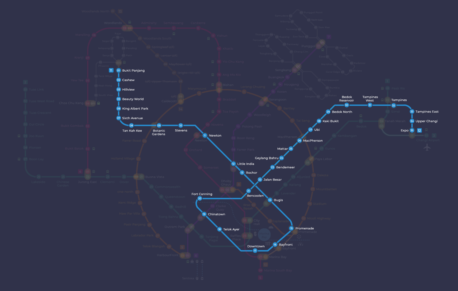
Stevens station at a glance
| Station codes | DT10TE11 |
|---|---|
| Lines | Downtown Line Thomson East Coast Line |
| Interchange | Yes, change between 2 lines here |
| Chinese name | 史蒂芬 |
| Tamil name | ஸ்டீவன்ஸ் |
| Next stations | |
| Train times | Downtown Line: first train leaves the terminus at 5:30 AM, last train 11:35 PM Thomson East Coast Line: first train leaves the terminus at 5:36 AM, last train 11:27 PM Full first and last train guide |
See Stevens on the map. The interactive map opens with this station highlighted, so you can trace the route from where you are.
Passengers can transfer between the Downtown Line and the Thomson-East Coast Line here without leaving the station. On the Downtown Line, neighbouring stations are Botanic Gardens towards the west and Newton towards the east. On the Thomson-East Coast Line, the station sits between Napier to the south and Mount Pleasant to the north. This makes Stevens a practical interchange point for journeys that cross between the two lines, with onward connections to Orchard, the city centre, and the eastern and northern parts of Singapore.
The surrounding neighbourhood is characterised by tree-lined roads, private housing estates, and a generally calm, residential atmosphere. The area around Stevens Road and Dunearn Road is typical of Singapore's central residential districts, with mature greenery and a relatively unhurried pace compared to the city centre. Those looking for amenities will find small shops and eateries within a short walk, though the station is primarily used by residents rather than visitors heading to major tourist attractions.
Around Stevens station
Stevens MRT station sits within a quiet, largely residential district characterised by leafy streets and low-density housing. The surrounding area blends green recreational space, with Malcolm Park nearby, and educational institutions such as the National University of Singapore's Bukit Timah campus. It is a calm, unhurried neighbourhood rather than a commercial or shopping hub.
| Place | Type | Distance | Why go |
|---|---|---|---|
| Malcolm Park | Park | About 320 m (~5 min walk) | A local park suitable for a quiet outdoor stroll or relaxation. |
| Tanglin Community Club | Community club | About 400 m (~7 min walk) | A community facility offering social and recreational programmes for residents. |
| Institute of Policy Studies | University | About 700 m (~11 min walk) | A public policy research and teaching institution within a university setting. |
| National University of Singapore (Bukit Timah) | University | About 810 m (~13 min walk) | A university campus hosting law and other faculties in a heritage setting. |
| Jacob Ballas Children's Garden | Attraction | About 830 m (~13 min walk) | A children's garden within the Botanic Gardens area, designed for family visits. |
| The Bunker | Attraction | About 880 m (~14 min walk) | A heritage attraction related to Singapore's wartime history, worth exploring. |
| Sprouts Food Place | Food centre | About 920 m (~15 min walk) | A food centre offering a variety of local cooked food options. |
| Healing Garden | Attraction | About 970 m (~16 min walk) | A therapeutic garden within the Botanic Gardens area, focused on medicinal plants. |
Places and straight-line distances from OpenStreetMap data (© OpenStreetMap contributors). Actual walking routes may be longer.
How to get to Stevens by MRT
Worked out from the network map. Stop counts are station to station and do not include walking or waiting time.
| From Changi Airport | Take the East West Line from Changi Airport to Bugis (10 stops), then change to the Downtown Line from Bugis to Stevens (4 stops). About 14 stops with 1 change. |
|---|---|
| From Orchard | Take the Thomson East Coast Line from Orchard to Stevens (3 stops). About 3 stops, no changes. |
| From City Hall | Take the North South Line from City Hall to Newton (4 stops), then change to the Downtown Line from Newton to Stevens (1 stop). About 5 stops with 1 change. |
| From Jurong East | Take the East West Line from Jurong East to Buona Vista (3 stops), then change to the Circle Line from Buona Vista to Botanic Gardens (3 stops), then change to the Downtown Line from Botanic Gardens to Stevens (1 stop). About 7 stops with 2 changes. |
| From Woodlands | Take the Thomson East Coast Line from Woodlands to Stevens (8 stops). About 8 stops, no changes. |
| From HarbourFront | Take the North East Line from HarbourFront to Little India (4 stops), then change to the Downtown Line from Little India to Stevens (2 stops). About 6 stops with 1 change. |
Tips for using Stevens station
- Stevens is an interchange station between the Downtown Line and the Thomson East Coast Line, so plan your route according to which line best suits your onward destination.
- Malcolm Park and Tanglin Community Club are the closest destinations and are manageable on foot, but most other places on this list are a 10 to 16 minute walk, so factor in extra time especially in warm weather.
- For destinations such as Jacob Ballas Children's Garden, The Bunker, the Healing Garden and Sprouts Food Place, consider taking a bus from the roads near the station rather than walking the full distance.
- During morning and evening peak hours the station can be busier due to interchange traffic, so allow a little extra time when transferring between lines or exiting the station.
All stations on the Downtown Line
In order along the line, with Stevens marked. Stations with their own guide are linked.
| Code | Station | Interchange |
|---|---|---|
| DT1 | Bukit Panjang | DT / BP |
| DT2 | Cashew | – |
| DT3 | Hillview | – |
| DT5 | Beauty World | – |
| DT6 | King Albert Park | – |
| DT7 | Sixth Avenue | – |
| DT8 | Tan Kah Kee | – |
| DT9 | Botanic Gardens | DT / CC |
| DT10 | Stevens (you are here) | DT / TE |
| DT11 | Newton | NS / DT |
| DT12 | Little India | DT / NE |
| DT13 | Rochor | – |
| DT14 | Bugis | DT / EW |
| DT15 | Promenade | CC / DT |
| DT16 | Bayfront | CE / DT |
| DT17 | Downtown | – |
| DT18 | Telok Ayer | – |
| DT19 | Chinatown | DT / NE |
| DT20 | Fort Canning | – |
| DT21 | Bencoolen | – |
| DT22 | Jalan Besar | – |
| DT23 | Bendemeer | – |
| DT24 | Geylang Bahru | – |
| DT25 | Mattar | – |
| DT26 | MacPherson | CC / DT |
| DT27 | Ubi | – |
| DT28 | Kaki Bukit | – |
| DT29 | Bedok North | – |
| DT30 | Bedok Reservoir | – |
| DT31 | Tampines West | – |
| DT32 | Tampines | EW / DT |
| DT33 | Tampines East | – |
| DT34 | Upper Changi | – |
| DT35 | Expo | DT / CG |
Read the full Downtown Line guide.
All stations on the Thomson East Coast Line
In order along the line, with Stevens marked. Stations with their own guide are linked.
| Code | Station | Interchange |
|---|---|---|
| TE1 | Woodlands North | – |
| TE2 | Woodlands | NS / TE |
| TE3 | Woodlands South | – |
| TE4 | Springleaf | – |
| TE5 | Lentor | – |
| TE7 | Bright Hill | – |
| TE8 | Upper Thomson | – |
| TE9 | Caldecott | CC / TE |
| TE10 | Mount Pleasant | – |
| TE11 | Stevens (you are here) | DT / TE |
| TE12 | Napier | – |
| TE13 | Orchard Boulevard | – |
| TE14 | Orchard | TE / NS |
| TE15 | Great World | – |
| TE16 | Havelock | – |
| TE17 | Outram Park | TE / EW |
| TE18 | Maxwell | – |
| TE19 | Shenton Way | – |
| TE20 | Marina Bay | CE / TE |
| TE21 | Marina South | – |
| TE22 | Gardens by the Bay | – |
Read the full Thomson East Coast Line guide.
Stevens station: common questions
Which line is Stevens MRT station on?
Stevens is on the Downtown Line and the Thomson East Coast Line. Its station codes are DT10 and TE11.
Is Stevens an interchange station?
Yes. You can change between the Downtown Line and the Thomson East Coast Line inside the station without leaving the paid area.
What time is the first and last train at Stevens?
Times below are for the first and last train leaving the line terminus; trains reach Stevens a few minutes later depending on its position on the line. Downtown Line first train 5:30 AM, last train 11:35 PM. Thomson East Coast Line first train 5:36 AM, last train 11:27 PM. Check the operator for holiday changes.
What is near Stevens MRT station?
Nearby places include Malcolm Park at approximately 320 metres, Tanglin Community Club at approximately 400 metres, the Institute of Policy Studies and the National University of Singapore Bukit Timah campus, as well as Jacob Ballas Children's Garden and the Healing Garden, all within roughly a kilometre of the station.
Is there a food centre close to Stevens MRT station?
The nearest food centre is Sprouts Food Place, at approximately 920 metres from the station, which is roughly a 15 minute walk away.
How far is Jacob Ballas Children's Garden from Stevens MRT station?
Jacob Ballas Children's Garden is approximately 830 metres from Stevens MRT station in a straight line, which works out to roughly a 13 minute walk.
How do I get to Stevens from Changi Airport by MRT?
Take the East West Line from Changi Airport to Bugis (10 stops), then change to the Downtown Line from Bugis to Stevens (4 stops). About 14 stops with 1 change.
Sources: station codes, line colours and interchanges from the LTA rail system map; operating hours from SMRT and SBS Transit. Last reviewed September 2026.
News and guides mentioning Stevens
- Most Instagram-Worthy MRT Stations in Singapore 28 Sep 2026
- Art for the Heart 2026: Shortlisted Works at Bayfront MRT 11 Sep 2026
- Woodlands North Station Complete: RTS Link Opens 2027 7 Sep 2026
- Singapore MRT Art in Transit Programme Explained 13 Aug 2026
Plan the rest of the trip
Every station on the Downtown Line and the Thomson East Coast Line is listed on its line guide, with the full route and interchanges. For times, see the first and last train guide, and for the whole network in one view use the interactive Singapore MRT map or the PDF map.