
Mount Pleasant MRT Station
Mount Pleasant MRT station is an underground station on the Thomson-East Coast Line, built in the Novena district on land that once formed part of the Old Police Academy grounds. Its station code is TE10, and it is operated by SMRT Trains. The station is not open yet. Trains on the line already run through it, but they do not stop here.
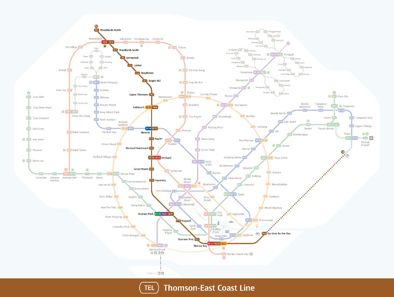
Mount Pleasant on the Thomson East Coast Line map
Mount Pleasant MRT station at a glance
| Station codes | TE10 |
|---|---|
| Lines | Thomson East Coast Line |
| Line colour | Brown line (Thomson East Coast Line) |
| Interchange | No, single line station |
| Chinese name | 快乐山 |
| Tamil name | மவுண்ட் பிளசண்ட் |
| Next stations |
See Mount Pleasant on the map. The interactive map opens with this station highlighted, so you can trace the route from where you are.
The station was built ahead of a new housing estate planned for the Mount Pleasant area. Once that estate takes shape, the station will give its future residents a direct rail link to the rest of the network. It will open to passengers when the surrounding district has been developed. Until then, travellers heading to this part of Novena will need to start or end their journey at another station.
History of Mount Pleasant MRT station
The station was first announced on 29 August 2012 as one of the stops on the planned Thomson Line, which was later combined with the Eastern Region Line to create the Thomson-East Coast Line. A groundbreaking ceremony on 24 January 2015 marked the formal start of work, and some of the old academy buildings were demolished to make room for the project. Although the structure was finished, the Land Transport Authority announced on 23 November 2021 that the opening would wait for the new Mount Pleasant housing estate. Since this section of the line began running on 13 November 2022, trains have passed through without stopping.
Inside Mount Pleasant MRT station
Mount Pleasant MRT station is a designated Civil Defence Shelter, so its underground structure is designed to protect the public during an emergency. For now the station is mothballed, and it will remain closed to passengers until it opens alongside the new district.
When it opens, Mount Pleasant MRT station will put several places within walking distance. The closest of these places are:
- Catholic Junior College is about 360 m away, roughly a six minute walk, which makes the station a likely choice for students and staff.
- Chancery Lane Pill Box is about 800 m from the station, around 13 minutes on foot, for anyone interested in local landmarks.
- Novena Rise Park is about 930 m away, around a 15 minute walk, and suits a short outdoor break.
- Tanglin Community Club is about 1080 m away, roughly 18 minutes on foot, for residents taking part in community activities.
Several food centres, including Teck Seng and Sin Mee Eating House, are also about 15 minutes away on foot, which will be handy for a meal before or after a journey.
Around Mount Pleasant MRT station
Mount Pleasant station sits within a quiet, predominantly residential and institutional neighbourhood in the central-north part of Singapore. Catholic Junior College is one of the most prominent landmarks close by, giving the area a studious character. Greenery and low-rise surroundings define much of the district, with Novena Rise Park adding a patch of nature within the wider vicinity.
| Place | Type | Distance | Why go |
|---|---|---|---|
| Catholic Junior College | College | About 360 m (~6 min walk) | Visit Catholic Junior College for pre-university education and campus facilities. |
| Catholic Junior College Hostel | College | About 440 m (~7 min walk) | The Catholic Junior College Hostel provides residential accommodation for college students. |
| Chancery Lane Pill Box | Attraction | About 800 m (~13 min walk) | Chancery Lane Pill Box is a heritage military structure worth exploring for history enthusiasts. |
| Teck Seng | Food centre | About 910 m (~15 min walk) | Teck Seng is a local food centre offering a range of everyday hawker meals. |
| Sin Mee Eating House | Food centre | About 910 m (~15 min walk) | Sin Mee Eating House is a neighbourhood eating spot for casual local food. |
| Novena Rise Park | Park | About 930 m (~15 min walk) | Novena Rise Park is a green space suitable for a leisurely outdoor walk. |
| Maxim | Food centre | About 970 m (~16 min walk) | Maxim is a local food centre where you can find affordable everyday meals. |
| Tanglin Community Club | Community club | About 1080 m (~18 min walk) | Tanglin Community Club hosts community activities, classes and neighbourhood events. |
Places and straight-line distances from OpenStreetMap data (© OpenStreetMap contributors). Actual walking routes may be longer.
Tips for using Mount Pleasant MRT station
- Catholic Junior College and its hostel are within a comfortable walking distance of about 6 to 7 minutes, making them easy to reach on foot.
- Places beyond 800 metres, such as Chancery Lane Pill Box, Teck Seng, Sin Mee Eating House, Maxim and Tanglin Community Club, involve a longer walk of 13 minutes or more, so consider taking a bus or ride-hailing service if you prefer.
- Trains do not stop here yet. Use Caldecott (TE9) or Stevens (TE11) instead.
- Allow extra travel time during morning and evening peak hours, as trains and connecting transport options can be busier than usual.
All stations on the Thomson East Coast Line
Open stations in order along the line. Mount Pleasant is not open yet, so it is not listed. Stations with their own guide are linked.
| Code | Station | Interchange |
|---|---|---|
| TE1 | Woodlands North | None |
| TE2 | Woodlands | NS / TE |
| TE3 | Woodlands South | None |
| TE4 | Springleaf | None |
| TE5 | Lentor | None |
| TE6 | Mayflower | None |
| TE7 | Bright Hill | None |
| TE8 | Upper Thomson | None |
| TE9 | Caldecott | CC / TE |
| TE11 | Stevens | DT / TE |
| TE12 | Napier | None |
| TE13 | Orchard Boulevard | None |
| TE14 | Orchard | TE / NS |
| TE15 | Great World | None |
| TE16 | Havelock | None |
| TE17 | Outram Park | TE / EW / NE |
| TE18 | Maxwell | None |
| TE19 | Shenton Way | None |
| TE20 | Marina Bay | CE / TE / NS |
| TE22 | Gardens by the Bay | None |
| TE23 | Tanjong Rhu | None |
| TE24 | Katong Park | None |
| TE25 | Tanjong Katong | None |
| TE26 | Marine Parade | None |
| TE27 | Marine Terrace | None |
| TE28 | Siglap | None |
| TE29 | Bayshore | None |
Read the full Thomson East Coast Line guide.
Mount Pleasant MRT station: common questions
Which line is Mount Pleasant MRT station on?
Mount Pleasant is on the Thomson East Coast Line. Its station code is TE10.
Is Mount Pleasant an interchange station?
No. Mount Pleasant is served by the Thomson East Coast Line only. The nearest interchange is shown in the next stations row above.
What is near Mount Pleasant MRT station?
Nearby places include Catholic Junior College at approximately 360 metres, Chancery Lane Pill Box at approximately 800 metres, and Novena Rise Park at approximately 930 metres, among others.
Which food centre is closest to Mount Pleasant MRT station?
Teck Seng and Sin Mee Eating House are both the closest food options, each at approximately 910 metres straight-line distance, roughly a 15-minute walk.
How far is Catholic Junior College from Mount Pleasant MRT station?
Catholic Junior College is approximately 360 metres from the station, which is roughly a 6-minute walk.
Sources: station codes, line colours and interchanges from the LTA rail system map; operating hours from SMRT and SBS Transit. Last reviewed October 2026.
News and guides mentioning Mount Pleasant
- Future MRT Map Singapore: Every New Line and Extension to 2040 21 Oct 2026
- Commuter Fatigue and the North-South Corridor Delay 6 Oct 2026
- シンガポールMRT路線図 2026(日本語ガイド) 4 Oct 2026
- MRT Walking Map (2017) 11 Aug 2023
Plan the rest of the trip
Every station on the Thomson-East Coast Line is listed on its line guide, with the full route and interchanges. For times, see the first and last train guide, and for the whole network in one view use the interactive Singapore MRT map or the PDF map.