
Serangoon MRT Station
Serangoon MRT station is an interchange station serving both the Circle Line (station code CC13) and the North East Line (station code NE12). It sits in the heart of Serangoon, a well-established residential town in the north-east of Singapore. The area around the station is a busy neighbourhood centre, with a mix of housing estates, local shops, and amenities that make it one of the more active community nodes in that part of the island.
Serangoon on the Circle Line map
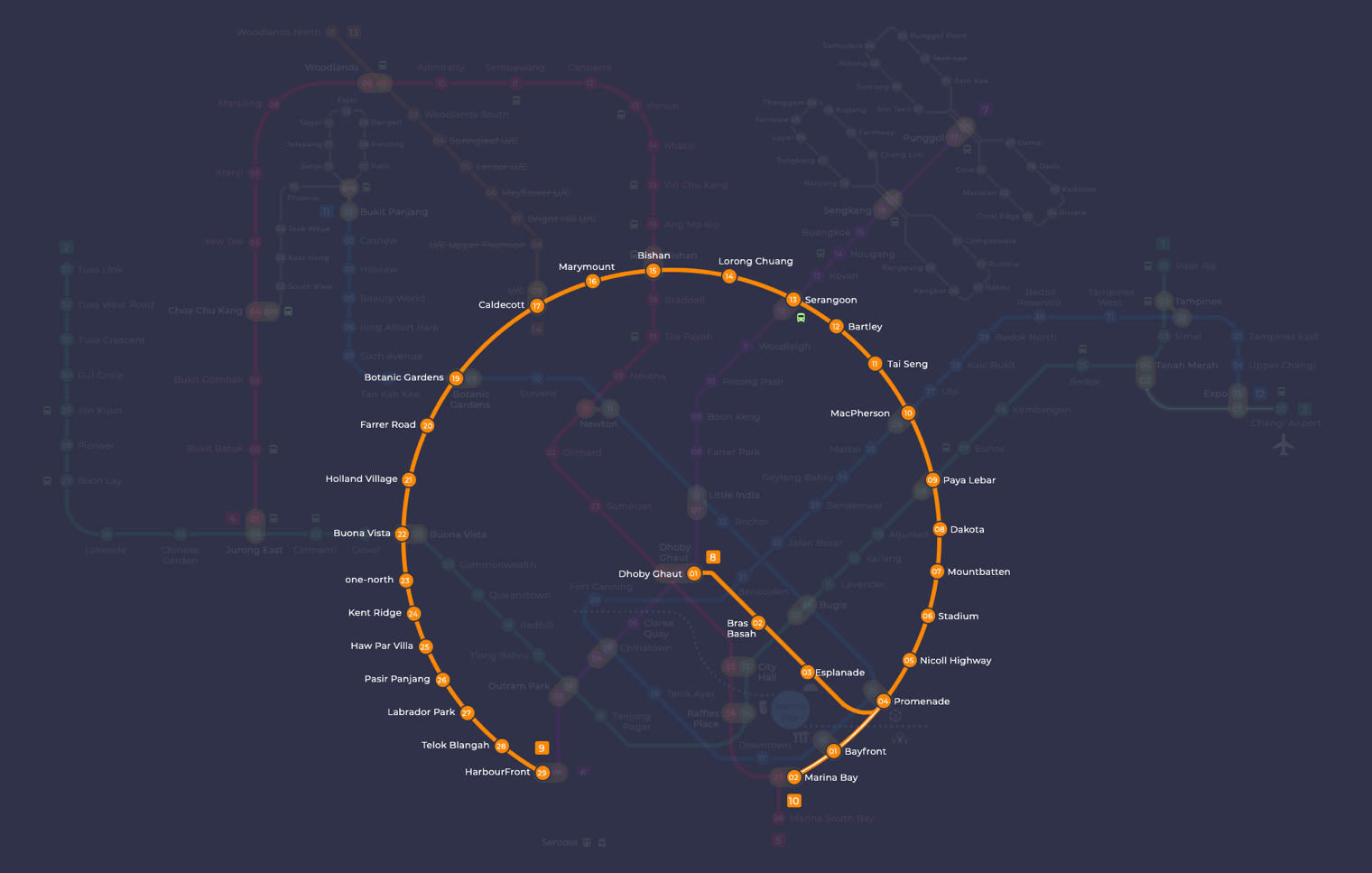
Serangoon station at a glance
| Station codes | CC13NE12 |
|---|---|
| Lines | Circle Line North East Line |
| Interchange | Yes, change between 2 lines here |
| Chinese name | 实龙岗 |
| Tamil name | சிராங்கூன் |
| Next stations | |
| Train times | Circle Line: first train leaves the terminus at 5:37 AM, last train 11:50 PM North East Line: first train leaves the terminus at 5:42 AM, last train 11:55 PM Full first and last train guide |
See Serangoon on the map. The interactive map opens with this station highlighted, so you can trace the route from where you are.
Passengers can transfer between the Circle Line and the North East Line here without leaving the station. On the Circle Line, neighbouring stations are Bartley in one direction and Lorong Chuan in the other. On the North East Line, the adjacent stations are Woodleigh towards the city and Potong Pasir in the opposite direction. This makes Serangoon a practical stop for travellers moving between the north-east corridor and the broader circular route that connects many parts of Singapore.
The station sits directly alongside NEX, a large shopping mall that is connected to the station and contains supermarkets, restaurants, retail shops, and a cinema. The surrounding streets of Serangoon Central bring you quickly to wet markets, hawker centres, and everyday amenities that serve the local population. The general neighbourhood has a well-used, lived-in character, with a good range of food options and shops within easy walking distance of the station exits.
Around Serangoon station
Serangoon station sits at the heart of a busy residential and commercial hub centred on Serangoon Central. The area is well served by shopping and dining options, with Food Junction and Food Republic both within a short walk. Serangoon Public Library and Serangoon Bus Interchange add to the everyday amenities that make this a practical base for residents and visitors alike.
| Place | Type | Distance | Why go |
|---|---|---|---|
| Food Junction | Food centre | About 50 m (~1 min walk) | Visit Food Junction for a wide variety of hawker-style meals in a food court setting. |
| Serangoon Public Library | Library | About 90 m (~1 min walk) | Visit Serangoon Public Library to borrow books, study or access community programmes. |
| Serangoon Bus Interchange | Bus interchange | About 130 m (~2 min walk) | Use Serangoon Bus Interchange to connect to bus services across the wider region. |
| Food Republic | Food centre | About 140 m (~2 min walk) | Visit Food Republic for another food court option with a range of local and Asian dishes. |
| Serangoon Central Village | Market / hawker centre | About 420 m (~7 min walk) | Visit Serangoon Central Village for a traditional wet market and local hawker food. |
| Nanyang Junior College | College | About 690 m (~11 min walk) | Nanyang Junior College is a pre-university institution for students in the area. |
| Serangoon Stadium | Stadium | About 740 m (~12 min walk) | Serangoon Stadium is a community sports facility used for football and athletics. |
| Upper Serangoon Shopping Centre | Shopping mall | About 810 m (~13 min walk) | Upper Serangoon Shopping Centre offers retail shops serving the surrounding neighbourhood. |
Places and straight-line distances from OpenStreetMap data (© OpenStreetMap contributors). Actual walking routes may be longer.
How to get to Serangoon by MRT
Worked out from the network map. Stop counts are station to station and do not include walking or waiting time.
| From Changi Airport | Take the East West Line from Changi Airport to Paya Lebar (6 stops), then change to the Circle Line from Paya Lebar to Serangoon (4 stops). About 10 stops with 1 change. |
|---|---|
| From Orchard | Take the North South Line from Orchard to Bishan (5 stops), then change to the Circle Line from Bishan to Serangoon (2 stops). About 7 stops with 1 change. |
| From City Hall | Take the North South Line from City Hall to Dhoby Ghaut (1 stop), then change to the North East Line from Dhoby Ghaut to Serangoon (5 stops). About 6 stops with 1 change. |
| From Jurong East | Take the East West Line from Jurong East to Buona Vista (3 stops), then change to the Circle Line from Buona Vista to Serangoon (8 stops). About 11 stops with 1 change. |
| From Woodlands | Take the North South Line from Woodlands to Bishan (8 stops), then change to the Circle Line from Bishan to Serangoon (2 stops). About 10 stops with 1 change. |
| From HarbourFront | Take the North East Line from HarbourFront to Serangoon (8 stops). About 8 stops, no changes. |
Tips for using Serangoon station
- Food Junction, Serangoon Public Library, Serangoon Bus Interchange and Food Republic are all within a 2-minute walk, making them easy to reach on foot from the station.
- Serangoon is an interchange station serving both the Circle Line and the North East Line, so allow extra time during morning and evening peak hours when platforms and concourses can be crowded.
- Serangoon Central Village, Nanyang Junior College, Serangoon Stadium and Upper Serangoon Shopping Centre are all more than 400 m away, so consider taking a bus from Serangoon Bus Interchange rather than walking, especially in hot or wet weather.
- If you are transferring between the Circle Line and the North East Line, factor in a few extra minutes as the interchange can be busy, particularly on weekends and public holidays.
All stations on the Circle Line
In order along the line, with Serangoon marked. Stations with their own guide are linked.
| Code | Station | Interchange |
|---|---|---|
| CC2 | Bras Basah | – |
| CC3 | Esplanade | – |
| CC4 | Promenade | CC / DT |
| CC5 | Nicoll Highway | – |
| CC6 | Stadium | – |
| CC7 | Mountbatten | – |
| CC8 | Dakota | – |
| CC9 | Paya Lebar | CC / EW |
| CC10 | MacPherson | CC / DT |
| CC11 | Tai Seng | – |
| CC12 | Bartley | – |
| CC13 | Serangoon (you are here) | CC / NE |
| CC14 | Lorong Chuan | – |
| CC15 | Bishan | NS / CC |
| CC16 | Marymount | – |
| CC17 | Caldecott | CC / TE |
| CC19 | Botanic Gardens | DT / CC |
| CC20 | Farrer Road | – |
| CC21 | Holland Village | – |
| CC22 | Buona Vista | EW / CC |
| CC23 | one-north | – |
| CC24 | Kent Ridge | – |
| CC25 | Haw Par Villa | – |
| CC26 | Pasir Panjang | – |
| CC27 | Labrador Park | – |
| CC28 | Telok Blangah | – |
| CC29 | HarbourFront | CC / NE |
Read the full Circle Line guide.
All stations on the North East Line
In order along the line, with Serangoon marked. Stations with their own guide are linked.
| Code | Station | Interchange |
|---|---|---|
| NE1 | HarbourFront | CC / NE |
| NE4 | Chinatown | DT / NE |
| NE5 | Clarke Quay | – |
| NE6 | Dhoby Ghaut | NS / NE |
| NE7 | Little India | DT / NE |
| NE8 | Farrer Park | – |
| NE9 | Boon Keng | – |
| NE10 | Potong Pasir | – |
| NE12 | Serangoon (you are here) | CC / NE |
| NE13 | Woodleigh | – |
| NE14 | Hougang | – |
| NE15 | Buangkok | – |
| NE16 | Sengkang | NE / STC |
| NE17 | Punggol | NE / PTC |
Read the full North East Line guide.
Serangoon station: common questions
Which line is Serangoon MRT station on?
Serangoon is on the Circle Line and the North East Line. Its station codes are CC13 and NE12.
Is Serangoon an interchange station?
Yes. You can change between the Circle Line and the North East Line inside the station without leaving the paid area.
What time is the first and last train at Serangoon?
Times below are for the first and last train leaving the line terminus; trains reach Serangoon a few minutes later depending on its position on the line. Circle Line first train 5:37 AM, last train 11:50 PM. North East Line first train 5:42 AM, last train 11:55 PM. Check the operator for holiday changes.
What is near Serangoon MRT station?
Several amenities are within easy walking distance, including Food Junction, Serangoon Public Library, Serangoon Bus Interchange and Food Republic, all approximately 50 to 140 m away. Further out, at approximate distances of 420 m to 810 m, you will find Serangoon Central Village, Nanyang Junior College, Serangoon Stadium and Upper Serangoon Shopping Centre.
Which food centre or food court is closest to Serangoon station?
Food Junction is the closest, at approximately 50 m straight-line distance and roughly a 1-minute walk. Food Republic is the next nearest food court, at approximately 140 m away.
How far is Serangoon Stadium from Serangoon MRT station?
Serangoon Stadium is approximately 740 m away in a straight line, which is roughly a 12-minute walk. You may prefer to take a bus from Serangoon Bus Interchange to get there more quickly.
How do I get to Serangoon from Changi Airport by MRT?
Take the East West Line from Changi Airport to Paya Lebar (6 stops), then change to the Circle Line from Paya Lebar to Serangoon (4 stops). About 10 stops with 1 change.
Sources: station codes, line colours and interchanges from the LTA rail system map; operating hours from SMRT and SBS Transit. Last reviewed September 2026.
News and guides mentioning Serangoon
- Most Instagram-Worthy MRT Stations in Singapore 28 Sep 2026
- Power Bank Fire at Little India MRT Station 14 Sep 2026
- Man Collapses at Woodleigh MRT: Staff and Commuters Save His Life 10 Sep 2026
- MRT Station Art: Stories Behind Hougang, Newton & More 28 Aug 2026
Plan the rest of the trip
Every station on the Circle Line and the North East Line is listed on its line guide, with the full route and interchanges. For times, see the first and last train guide, and for the whole network in one view use the interactive Singapore MRT map or the PDF map.