
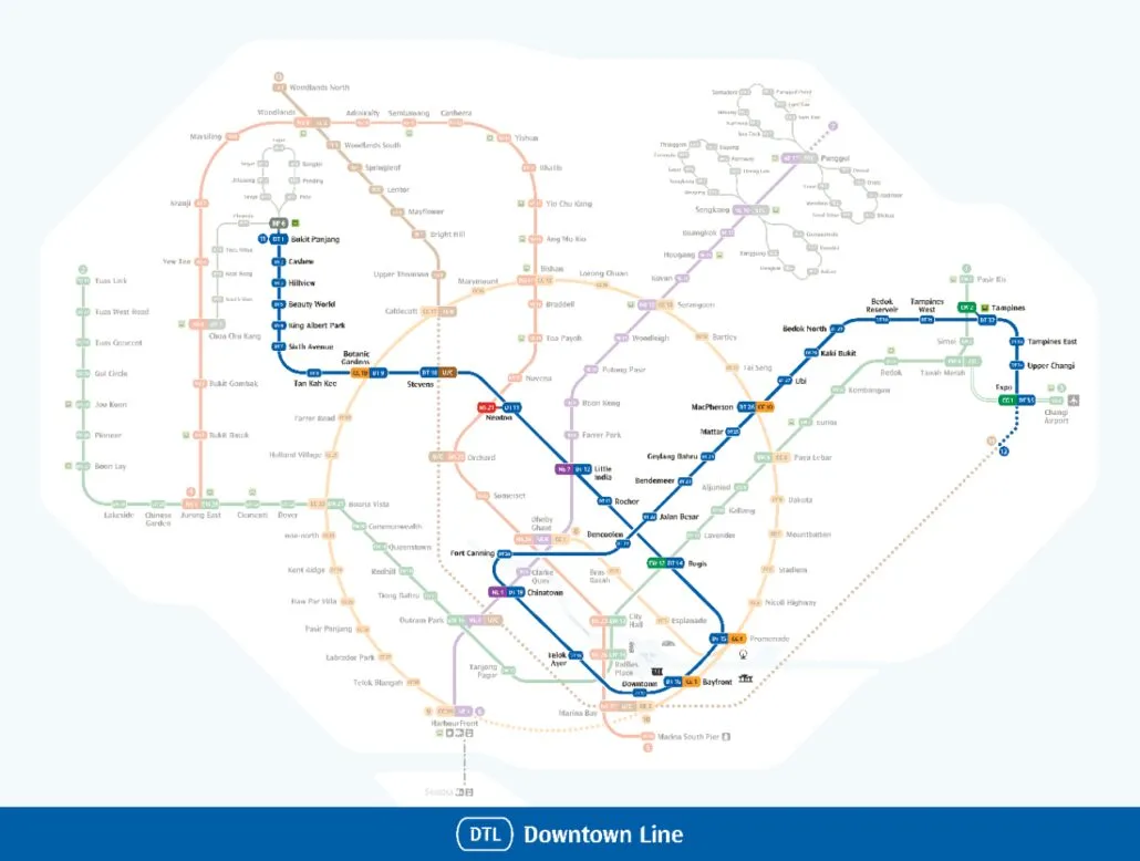
Full Downtown Line guide: every station, interchange and the route in one place.
This Downtown Line map shows the whole of Singapore’s blue line, coded DT, from Bukit Panjang (DT1) in the north-west to Expo (DT35) in the east. All 35 stations are open, and the line passes through the heart of the city on the way, linking to every other MRT line along its route. Use the map above to trace your journey, spot the interchanges, and count the stops before you board. For timings and station-by-station guides, see our complete Downtown Line guide.
About the image: The map image above is LTA’s Downtown Line map from 2022, drawn before Hume (DT4) opened on 28 February 2025. The station table further down this page is up to date.
How to read the Downtown Line map
The Downtown Line is drawn in blue, which is why many people simply call it the blue line. Each station carries a code made up of the letters DT and a number. The numbers start at DT1 Bukit Panjang and rise in order to DT35 Expo, so you can work out how many stops lie between two stations by subtracting one number from the other. Our guide to MRT line colours explains how the blue fits alongside the rest of the network.
Interchange stations appear with more than one code next to them. Newton, for example, shows DT11 alongside NS21, telling you that the red North South Line meets the Downtown Line there. Twelve of the 35 stations are interchanges, so the codes are worth checking before you plan a transfer.
The Downtown Line has no branches and no loop of its own. It runs as a single route, but it bends sharply through the city centre: it heads south through Bugis, Promenade and Bayfront to Chinatown, then turns north again through Fort Canning and Bencoolen before setting off east. This U-shape is the part of the map that confuses visitors most, so follow the station numbers rather than the compass.
Every station from DT1 to DT35 is in service. Stations elsewhere on the network that have not opened yet, such as Marina South and Mount Pleasant, are not stops on the Downtown Line today. To see how the network is expected to grow, look at our future MRT map.
Getting around Singapore? Find any station on the interactive MRT map, or save the PDF map to use offline.
Route and stations along the line
The line begins at Bukit Panjang (DT1), where you can change to the Bukit Panjang LRT. It then runs south-east through Cashew, Hillview and Hume, the newest station on the line, which opened on 28 February 2025. Beauty World comes next, followed by King Albert Park, Sixth Avenue and Tan Kah Kee. At Botanic Gardens (DT9) the Circle Line crosses, and one stop later at Stevens you can join the Thomson-East Coast Line.
Newton marks the start of the busier central stretch. From there the line calls at Little India, Rochor and Bugis, then swings south to Promenade and Bayfront, where the Circle Line’s Marina Bay extension begins. The Downtown station that gives the line its name is DT17, followed by Telok Ayer and Chinatown. After Chinatown the line turns back north, calling at Fort Canning and Bencoolen before heading out of the centre.
The eastern section runs through Jalan Besar, Bendemeer, Geylang Bahru and Mattar to MacPherson, a Circle Line interchange. It continues through Ubi, Kaki Bukit, Bedok North and Bedok Reservoir, then reaches Tampines West, Tampines and Tampines East. The final stops are Upper Changi and Expo (DT35), where you can change to the East West Line branch that runs to Changi Airport.
Where to change lines
- Bukit Panjang (DT1): Bukit Panjang LRT (BP6)
- Botanic Gardens (DT9): Circle Line (CC19)
- Stevens (DT10): Thomson-East Coast Line (TE11)
- Newton (DT11): North South Line (NS21)
- Little India (DT12): North East Line (NE7)
- Bugis (DT14): East West Line (EW12)
- Promenade (DT15): Circle Line (CC4)
- Bayfront (DT16): Circle Line Marina Bay extension (CE1)
- Chinatown (DT19): North East Line (NE4)
- MacPherson (DT26): Circle Line (CC10)
- Tampines (DT32): East West Line (EW2)
- Expo (DT35): East West Line Changi Airport branch (CG1)
The Circle Line now runs as a full loop after Keppel, Cantonment and Prince Edward Road opened in July 2026, which makes the three Circle Line interchanges on the Downtown Line more useful than before. To see every line together, open our interactive MRT map.
How the line grew
The Downtown Line started as two separate ideas. In October 2001, Transport Minister Yeo Cheow Tong announced plans for the Bukit Timah Line and the Eastern Region Line, and parts of both later became the Downtown Line. On 14 June 2005, the Land Transport Authority announced a short Downtown Extension from Millenia (now Promenade) to Chinatown, intended to serve the new business district at Marina Bay.
In 2007, Transport Minister Raymond Lim announced a single 33-station Downtown Line to be built in three stages, and in April that year the government committed S$12 billion to the project. Construction began with a groundbreaking at Chinatown on 12 February 2008. Work on the second stage started at Beauty World on 3 July 2009, and work on the third stage began at Expo on 28 November 2011. SBS Transit was appointed in August 2011 to run the line, and tunnelling for the eastern stage began at Mattar on 11 July 2012.
The project faced setbacks along the way. Alpine Bau, the main contractor for King Albert Park, Sixth Avenue and Tan Kah Kee, went bankrupt on 19 June 2013, and the Land Transport Authority had to bring in another firm. The line now has 35 stations, two more than first planned, and the latest addition is Hume, which opened in February 2025.
Downtown Line map: every station
Every station on the map in order, with its code and the lines you can change to. Station names link to our full station guides.
| Code | Station | Change to |
|---|---|---|
| DT1 | Bukit Panjang | BP6 |
| DT2 | Cashew | |
| DT3 | Hillview | |
| DT4 | Hume | |
| DT5 | Beauty World | |
| DT6 | King Albert Park | |
| DT7 | Sixth Avenue | |
| DT8 | Tan Kah Kee | |
| DT9 | Botanic Gardens | CC19 |
| DT10 | Stevens | TE11 |
| DT11 | Newton | NS21 |
| DT12 | Little India | NE7 |
| DT13 | Rochor | |
| DT14 | Bugis | EW12 |
| DT15 | Promenade | CC4 |
| DT16 | Bayfront | CE1 |
| DT17 | Downtown | |
| DT18 | Telok Ayer | |
| DT19 | Chinatown | NE4 |
| DT20 | Fort Canning | |
| DT21 | Bencoolen | |
| DT22 | Jalan Besar | |
| DT23 | Bendemeer | |
| DT24 | Geylang Bahru | |
| DT25 | Mattar | |
| DT26 | MacPherson | CC10 |
| DT27 | Ubi | |
| DT28 | Kaki Bukit | |
| DT29 | Bedok North | |
| DT30 | Bedok Reservoir | |
| DT31 | Tampines West | |
| DT32 | Tampines | EW2 |
| DT33 | Tampines East | |
| DT34 | Upper Changi | |
| DT35 | Expo | CG1 |
Frequently asked questions
Is the Downtown Line the blue line on the MRT map?
Yes. The Downtown Line is shown in blue on the MRT map and uses the code DT. If you are searching for the MRT blue line map, the map at the top of this page is the one you need.
How many stations are on the Downtown Line?
There are 35 open stations, numbered DT1 Bukit Panjang to DT35 Expo. Twelve of them are interchanges with other lines. To find the stop closest to you, try our nearest station finder.
Can I download the DT line map?
Yes. Our MRT map PDF shows the Downtown Line with the rest of the network and is easy to save to your phone or print. Check the MRT operating hours before a late journey, and the fares and fare calculator to see what your trip will cost.
Does the Downtown Line go to Changi Airport?
Not directly. The line ends at Expo (DT35), where you change to the East West Line branch (CG1), which runs one stop to Changi Airport.
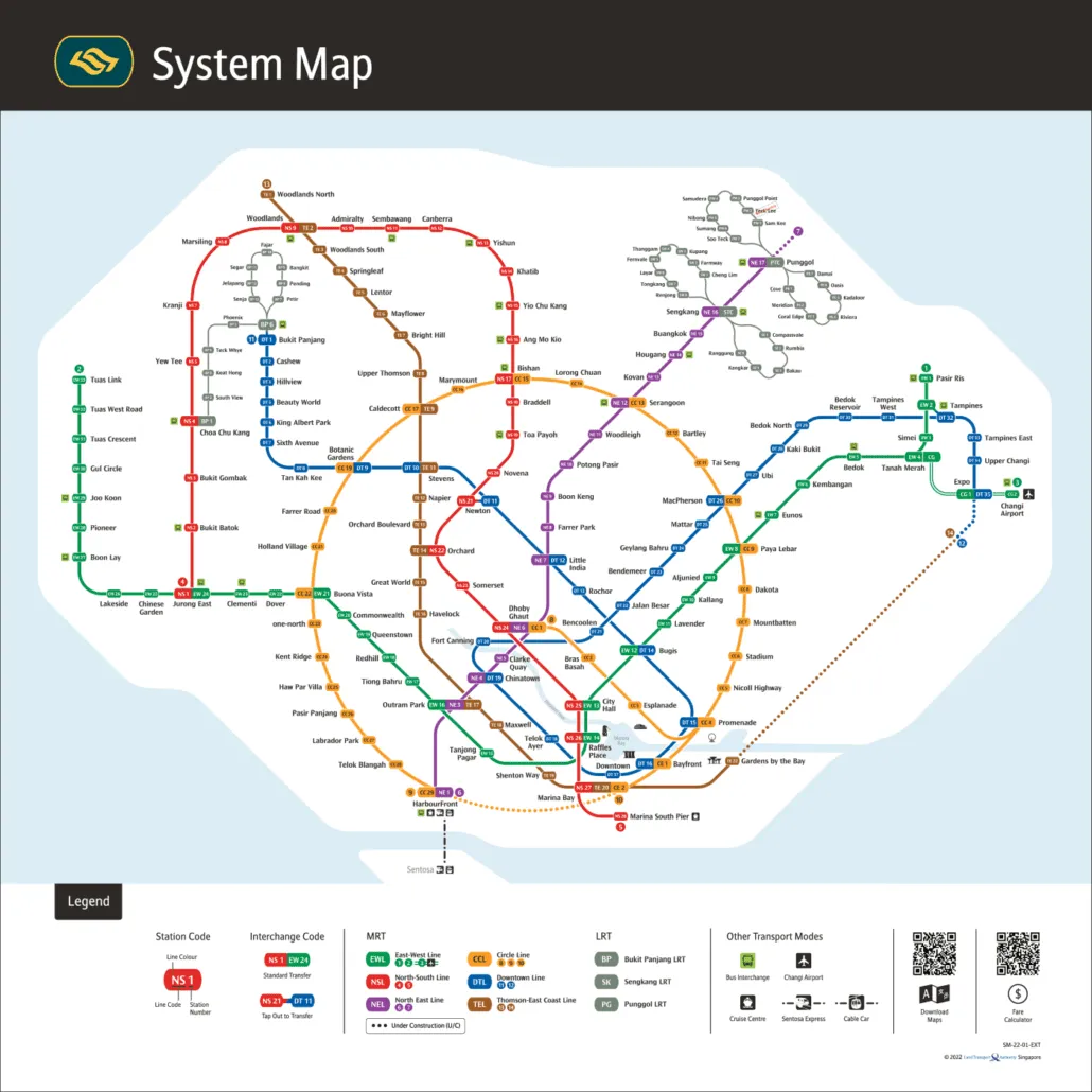
For the official version, see the LTA rail network map.