
Last updated . Facts checked against LTA announcements.
The Importance of the Singapore MRT Map
The Singapore MRT map is more than a route planner. It is a practical tool for getting around the island efficiently, whether you are heading to work or exploring a neighbourhood you have never visited before.
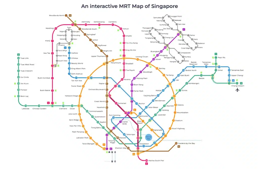
Singapore’s Mass Rapid Transit (MRT) network connects major landmarks, business districts and residential areas across six MRT lines and three LRT systems, making it the most reliable way to get around for most journeys. The Singapore MRT map brings all of that together in one place, showing you how every line and station connects so you can plan your trip before you leave.
The map is also a useful starting point for exploring less familiar parts of the city. Follow a line to its outer stations and you will often find parks, heritage streets and local food spots that see far fewer visitors than the city centre.
Getting around Singapore? Find any station on the interactive MRT map, or save the PDF map to use offline.
Interesting Spots Accessible via the Singapore MRT Map
-
Haw Par Villa (Circle Line, Haw Par Villa Station)
Haw Par Villa is one of Singapore’s more unusual attractions, with over a thousand statues and dioramas depicting scenes from Chinese mythology and folklore. It sits on the western side of the island and is worth a visit if you are interested in culture or history. Take the Circle Line to Haw Par Villa MRT Station and the park is a short walk away.
-
Kampong Glam (Downtown Line, Bugis Station)
Kampong Glam is one of Singapore’s most historically rich neighbourhoods, and Bugis on the Downtown Line puts you right at its edge. You will find preserved shophouses lining narrow alleys, independent boutiques and the grand Sultan Mosque all within walking distance of each other. It is a place where old Singapore and the modern city sit comfortably side by side.
- MacRitchie Reservoir (Circle Line, Caldecott Station)
MacRitchie Reservoir is the go-to escape for nature lovers who need a break from the city. The reservoir is ringed by tropical forest and hiking trails, including the elevated TreeTop Walk suspension bridge. Take the Circle Line to Caldecott, then catch a bus or walk down to the park entrance.
-
Katong and Joo Chiat (East West Line, Paya Lebar Station)
Katong and Joo Chiat are the heart of Singapore’s Peranakan heritage, with rows of well-preserved shophouses, local food stalls, and colourful street art. Paya Lebar on the East West Line is the most convenient stop, leaving you a short walk or ride from the main strips. Once you’re there, set aside time to explore the side streets and try some Nyonya food at one of the neighbourhood’s long-standing spots.
3 Best Routes With The Help Of Singapore MRT Map
Knowing the right connections on the Singapore MRT map can cut your travel time significantly, especially when you’re covering several destinations in a single day. Here are some of the most efficient routes to consider:
-
Understanding the MRT Lines
Singapore’s MRT has six main lines: the North South Line (red), East West Line (green), North East Line (purple), Circle Line (orange), Downtown Line (blue) and Thomson-East Coast Line (brown). The lines cover most parts of the city, and many stations let you switch between two or even three lines without leaving the paid zone. The better you understand how these lines connect, the quicker you will get around.
-
Use Interchange Stations Wisely
Interchange stations, where two or more lines meet, are the key to getting across the city quickly. A few of the most useful ones are Dhoby Ghaut (North South, North East and Circle Lines), Bugis (East West and Downtown Lines) and Paya Lebar (East West and Circle Lines). Planning your route around these interchanges, rather than going the most obvious way, can cut your journey time significantly.
-
Avoid Peak Hour Crowds
The busiest times on the MRT are roughly 7:00 to 9:00 am and 5:00 to 7:00 pm on weekdays. Trains can be packed enough that you miss the first one or two, which adds time to your journey. If your schedule allows, shifting your trip by even half an hour makes a noticeable difference. The Singapore MRT map can help you spot an alternative route that may be less crowded at busy times.
-
Explore the Lesser-Known Stations
Beyond the well-known stops like Orchard, Raffles Place and Marina Bay, the network reaches some genuinely interesting spots. Labrador Park on the Circle Line puts you right next to a quiet coastal park with good sea views. Woodleigh on the North East Line sits beside Bidadari Park, a green, low-key area that most visitors never find.
-
Use MRT Apps and Online Tools
A few apps make getting around much easier. MyTransport.SG and Citymapper both offer real-time train timings, disruption alerts and journey planning, so you can pick the quickest route before you leave the house. If you are new to Singapore, both are worth downloading before your first trip.
Upcoming Changes in the Singapore MRT Map
The network is still growing. Cross Island Line Phase 1, running from Aviation Park to Bright Hill, is targeted for 2030, with Phase 2 and a Punggol extension following in 2032 and Phase 3 later in the 2030s. When complete, it will be one of Singapore’s longest fully underground lines, connecting the east to the west.
Closer to now, Thomson-East Coast Line Stage 5 (Bedok South and Sungei Bedok) is due in the second half of 2026, extending the line further along the east coast. The Downtown Line is also set to grow, with Xilin and Sungei Bedok stations planned for the second half of 2026, and a further extension to Sungei Kadut targeted by 2035. The Jurong Region Line Stage 1 is expected around mid 2028.
Conclusion
The Singapore MRT map is more than a wayfinding tool. Once you understand how the lines connect and where the interchanges are, you can move around the city quickly and with very little stress. Whether you are heading to a park, a cultural spot or the office, the network usually gets you closer than you expect.
Next time you are planning a trip across town, give the map a proper look before you go. You might find a faster route than you assumed, or spot a station that drops you right where you want to be.
For official updates on the rail network, check the Land Transport Authority (LTA) website.
Frequently asked questions
How do I pay for the MRT in Singapore?
You can pay using a contactless bank card, mobile wallet or an EZ-Link/SimplyGo card tapped at the fare gates. If you are visiting, a Singapore Tourist Pass lets you make unlimited trips for a set number of days, which can be convenient if you plan to ride often.
How many stations does the North East Line have?
The North East Line has 17 stations, running from HarbourFront to Punggol Coast. The most recent addition was Punggol Coast, which opened on 10 December 2024.
What is the latest MRT line to open new stations in Singapore?
The Circle Line was the latest, adding Keppel, Cantonment and Prince Edward Road on 12 July 2026 and completing its loop. Before that, Hume joined the Downtown Line on 28 February 2025.