

Full East West Line guide: every station, interchange and the route in one place.
The East West Line map traces Singapore’s green line, running from Pasir Ris (EW1) in the east to Tuas Link (EW33) in the far west. All 33 stations on the main line are open, numbered in order from EW1 to EW33, and a short two-station branch (coded CG) leaves the line for Expo and Changi Airport. Between those ends the line passes through the heart of the city at Bugis, City Hall and Raffles Place, crossing almost every other rail line in Singapore along the way. If you are getting around the east, the city centre or the west, this is very likely the line you will spend the most time on.
How to read the East West Line map
The East West Line is shown in green, which is why many people simply call it the green line. Every station carries an EW code followed by a number. The numbers rise as you travel west, so EW1 is Pasir Ris and EW33 is Tuas Link. That makes the codes a handy shortcut: a lower number means you are heading east, a higher one means you are heading west. If you want to know how the other line colours fit together, our guide to MRT line colours sets them all out.
Interchange stations are drawn as linked symbols showing more than one code, for example City Hall appears as both EW13 and NS25. Where you see two or three codes stacked together, you can change trains without leaving the paid area.
The Changi Airport branch is marked with its own CG codes: CG1 Expo and CG2 Changi Airport. It splits from the main line at Tanah Merah and runs as a shuttle, so heading to the airport usually means changing trains at Tanah Merah. There are no stations still under construction on the East West Line itself. The unopened stations you may see elsewhere on a network map, such as Marina South, Mount Pleasant, Bedok South, Sungei Bedok and Xilin, belong to other lines.
Getting around Singapore? Find any station on the interactive MRT map, or save the PDF map to use offline.
Route and stations along the line
Starting in the east, the line begins at Pasir Ris and runs through Tampines, where you can switch to the Downtown Line, then Simei and Tanah Merah, the junction for the airport branch. From there it continues through Bedok, Kembangan and Eunos to Paya Lebar, a busy interchange with the Circle Line. Aljunied, Kallang and Lavender bring you towards the city fringe.
The central section is where the line earns its keep. Bugis, City Hall and Raffles Place come in quick succession, and the last two are cross platform links with the North South Line. Tanjong Pagar follows, then Outram Park, one of the network’s three way interchanges, where the Thomson East Coast and North East lines meet. Heading west, the line runs through Tiong Bahru, Redhill, Queenstown and Commonwealth to Buona Vista for the Circle Line. Dover, the stop for Singapore Polytechnic, sits just before Clementi.
Jurong East is the western hub, linking with the North South Line. Beyond it the line passes Chinese Garden, Lakeside and Boon Lay, which serve Jurong West, then Pioneer and Joo Koon on the edge of the Jurong Industrial Estate. The final run takes in Gul Circle, Tuas Crescent and Tuas West Road before ending at Tuas Link. On the branch, Expo connects to the Downtown Line and Changi Airport sits underground between Terminal 2 and Terminal 3. For a fuller station by station breakdown with timings, see our complete East West Line guide.
Where to change lines
- Tampines (EW2): change to the Downtown Line (DT32)
- Paya Lebar (EW8): change to the Circle Line (CC9)
- Bugis (EW12): change to the Downtown Line (DT14)
- City Hall (EW13): change to the North South Line (NS25)
- Raffles Place (EW14): change to the North South Line (NS26)
- Outram Park (EW16): change to the Thomson East Coast Line (TE17) and the North East Line (NE3)
- Buona Vista (EW21): change to the Circle Line (CC22)
- Jurong East (EW24): change to the North South Line (NS1)
- Expo (CG1): change to the Downtown Line (DT35)
To see how these connections fit into the wider network, open our interactive MRT map, and use the fare calculator to check what a journey across several lines will cost.
How the line grew
The East West Line started life as part of the North South Line. Its first section, between City Hall and Outram Park, opened on 12 December 1987. It was extended west to Clementi on 12 March 1988 and to Lakeside on 5 November 1988.
The eastern extension to Tanah Merah opened on 4 November 1989, which is when the East West Line began running independently. Pasir Ris followed on 16 December 1989, ahead of schedule, and Boon Lay opened on 6 July 1990, completing the initial MRT system.
Expo opened on 10 January 2001. Dover, the network’s first infill station, built between Buona Vista and Clementi, opened on 18 October 2001. Changi Airport station followed on 8 February 2002. Pioneer and Joo Koon extended the line west on 28 February 2009, and the Tuas West extension, adding Gul Circle, Tuas Crescent, Tuas West Road and Tuas Link, began service on 18 June 2017.
The story is not finished. On 25 May 2019 it was announced that the Changi Airport branch will become part of the Thomson East Coast Line extension by 2040. Our future MRT map shows how the network is expected to change.
East West Line map: every station
Every station on the map in order, with its code and the lines you can change to. Station names link to our full station guides.
East West Line (EW)
| Code | Station | Change to |
|---|---|---|
| EW1 | Pasir Ris | |
| EW2 | Tampines | DT32 |
| EW3 | Simei | |
| EW4 | Tanah Merah | |
| EW5 | Bedok | |
| EW6 | Kembangan | |
| EW7 | Eunos | |
| EW8 | Paya Lebar | CC9 |
| EW9 | Aljunied | |
| EW10 | Kallang | |
| EW11 | Lavender | |
| EW12 | Bugis | DT14 |
| EW13 | City Hall | NS25 |
| EW14 | Raffles Place | NS26 |
| EW15 | Tanjong Pagar | |
| EW16 | Outram Park | TE17, NE3 |
| EW17 | Tiong Bahru | |
| EW18 | Redhill | |
| EW19 | Queenstown | |
| EW20 | Commonwealth | |
| EW21 | Buona Vista | CC22 |
| EW22 | Dover | |
| EW23 | Clementi | |
| EW24 | Jurong East | NS1 |
| EW25 | Chinese Garden | |
| EW26 | Lakeside | |
| EW27 | Boon Lay | |
| EW28 | Pioneer | |
| EW29 | Joo Koon | |
| EW30 | Gul Circle | |
| EW31 | Tuas Crescent | |
| EW32 | Tuas West Road | |
| EW33 | Tuas Link |
East West Line (Changi Airport branch) (CG)
| Code | Station | Change to |
|---|---|---|
| CG1 | Expo | DT35 |
| CG2 | Changi Airport |
Frequently asked questions
Is the green line MRT the same as the East West Line?
Yes. The East West Line is coloured green on every official map, so locals often call it the green line. Its stations use the EW code, and the airport branch uses CG.
How many stations are on the East West Line in Singapore?
The main line has 33 open stations, from Pasir Ris (EW1) to Tuas Link (EW33). The Changi Airport branch adds two more, Expo (CG1) and Changi Airport (CG2).
How do I get to Changi Airport on the EW line?
Ride the main line to Tanah Merah and change to the branch shuttle for Expo and Changi Airport. If you are coming from the Downtown Line, you can also change at Expo.
Can I download an East West Line map?
Yes. Our MRT map PDF shows the full East West Line alongside every other line, ready to save or print. Check the MRT operating hours before an early or late journey.
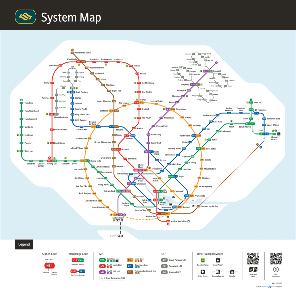
For the official version, see the LTA rail network map.