MRT Map (2014)

MRT Map (2014)

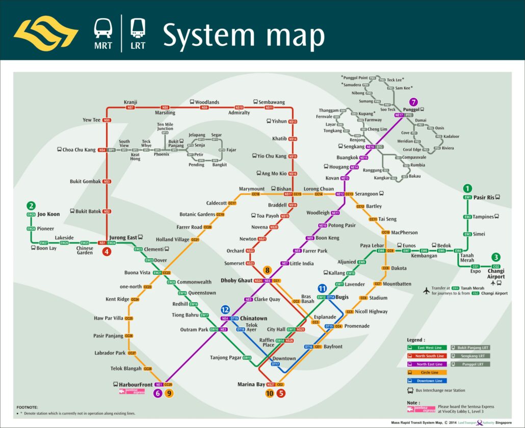
This MRT map is from 2014. Displaying the first part of the additional fifth blue line.

Exploring the Evolution of the MRT Map (2014)

In the fast-paced urban landscapes of today, efficient public transportation systems play a pivotal role in shaping how people navigate cities. Singapore, known for its exemplary public transport system, introduced the Mass Rapid Transit (MRT) system in 1987. This article delves into a specific snapshot of this system, focusing on the MRT map of the year 2014. Let’s embark on a journey through time and explore how the MRT looked in that significant year.

Table of Contents

  1. Introduction
  2. The Significance of the MRT Map
  3. MRT Expansion Initiatives in 2014
  4. Layout and Design of the 2014 MRT Map
  5. Navigational Ease for Commuters
  6. Integration of Technology
  7. Impact on Urban Development
  8. Cultural and Societal Considerations
  9. The Role of Public Feedback
  10. Comparing with Modern MRT Maps
  11. Challenges in Map Design
  12. A Glimpse into the Future
  13. Conclusion
  14. FAQs

Introduction

The Mass Rapid Transit system of Singapore, commonly referred to as the MRT, has been a cornerstone of the city-state’s transportation infrastructure. In 2014, the MRT system had already matured and undergone multiple expansions to serve a growing population.

The Significance of the MRT Map

The MRT map is not merely a visual representation of train routes; it’s a symbol of connectivity and accessibility. It provides a simplified depiction of the intricate network of train lines, helping both residents and tourists navigate the city with ease.

MRT Expansion Initiatives in 2014

The year 2014 witnessed several MRT expansion projects, including the opening of new lines and extensions to existing ones. These initiatives aimed to enhance connectivity to suburban areas and alleviate congestion in key transport nodes.

Layout and Design

The 2014 MRT map featured a balance between clarity and complexity. Distances between stations were accurately represented, while the map’s simplicity ensured that commuters could quickly identify their routes.

Navigational Ease for Commuters

The user-friendly design made it easy for commuters to plan their journeys. The colour-coded lines and clearly labelled stations minimized confusion, making the map a valuable tool for daily travel.

Integration of Technology

Even in 2014, technology played a role in enhancing the MRT experience. Digital versions of the map were available on various platforms, catering to tech-savvy commuters who preferred digital navigation.

Impact on Urban Development

it was more than a navigational aid; it influenced urban planning and development. Areas surrounding MRT stations often experienced increased property values and economic activity, showcasing the symbiotic relationship between transportation and city growth.

Cultural and Societal Considerations

The SMRT map also encapsulated Singapore’s cultural diversity. The names of stations reflected the city’s heritage and multicultural identity, reminding commuters of the rich tapestry that makes up the nation.

The Role of Public Feedback

The 2014 SMRT maps were a result of an iterative design based on public feedback. Commuters’ suggestions and preferences were considered, highlighting the collaborative nature of the system’s evolution.

Comparing with Modern MRT Maps

Comparing the 2014 map with its modern counterparts reveals the evolution of design principles. While the core layout remains consistent, newer maps incorporate advanced cartographic techniques and interactive features.

Challenges in Map Design

Designing comes with its challenges. Balancing geographical accuracy with visual clarity, especially in a dense urban environment, requires careful consideration.

A Glimpse into the Future

As Singapore’s MRT system continues to grow, future maps will likely integrate cutting-edge technologies. Augmented reality and real-time updates could redefine how commuters interact with the map.

Conclusion

The 2014 MRT map stands as a testament to Singapore’s commitment to efficient public transportation. It’s not just a tool for navigation but a representation of the city’s evolution, connectivity, and responsiveness to its citizens’ needs.

FAQs

Q: Is the 2014 MRT map still in use?

A: No, the MRT system has undergone multiple updates since 2014, leading to changes in the map’s layout and design.

Q: Were all the planned expansions in 2014 completed?

A: While some expansions were completed in 2014, the MRT system’s growth has continued beyond that year.

Q: How often are MRT maps updated?

A: MRT maps are updated regularly to reflect changes in routes, stations, and services.

Q: Are there any guided tours based on the MRT map?

A: Yes, themed tours that explore Singapore’s landmarks using the MRT system are available for tourists and locals alike.

Q: What is the longest MRT line in Singapore as of now?

A: As of now, the Downtown Line holds the distinction of being the longest MRT line in Singapore.