
Cantonment MRT Station
Cantonment MRT station is a station on the Circle Line, carrying the station code CC31. It sits in the southern part of Singapore's city fringe, serving a mixed area that combines older residential streets with pockets of commercial activity and open green spaces relatively close to the city centre.
Cantonment on the Circle Line map
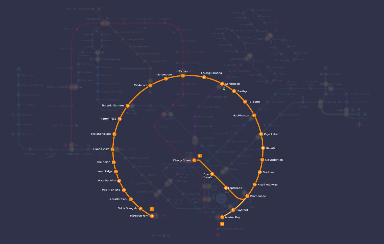
Cantonment station at a glance
| Station codes | CC31 |
|---|---|
| Lines | Circle Line |
| Interchange | No, single line station |
| Chinese name | 广东民 |
| Tamil name | கெண்டொன்மன் |
| Next stations | |
| Train times | Circle Line: first train leaves the terminus at 5:37 AM, last train 11:50 PM Full first and last train guide |
See Cantonment on the map. The interactive map opens with this station highlighted, so you can trace the route from where you are.
Cantonment is not an interchange station, so passengers needing to transfer to other lines will have to travel to a neighbouring stop. On the Circle Line, the two stations directly adjacent to Cantonment are Keppel towards the west and Prince Edward Road towards the east, both of which connect riders further along the Circle Line to major interchanges across the network.
The station sits beside the former Tanjong Pagar Railway Station, a conserved heritage building, and is a short walk from the Tanjong Pagar Distripark arts cluster. It is also close to Tanjong Pagar, a neighbourhood known for its rows of conserved shophouses and a variety of restaurants and cafes. The broader area also borders the southern waterfront district, making the station a reasonable starting point for exploring the low-rise streets, heritage architecture, and green corridors that characterise this part of the city.
Around Cantonment station
Cantonment MRT station sits within a mixed neighbourhood that combines light industrial heritage with creative and cultural uses, anchored by the Tanjong Pagar Distripark complex which houses SAM at Tanjong Pagar Distripark and several art galleries. Nearby residential streets give way to older shophouses and quiet lanes, with Baba House representing the area's Peranakan heritage a short walk away.
| Place | Type | Distance | Why go |
|---|---|---|---|
| Prestige Gallery | Gallery | About 100 m (~2 min walk) | Visit Prestige Gallery to browse contemporary or curated artworks on display. |
| SAM at Tanjong Pagar Distripark | Museum | About 100 m (~2 min walk) | SAM at Tanjong Pagar Distripark is a Singapore Art Museum venue worth exploring for local and regional art. |
| New Art Museum Singapore | Gallery | About 110 m (~2 min walk) | New Art Museum Singapore offers a gallery space for modern and contemporary art exhibitions. |
| Old Boys Gallery | Gallery | About 420 m (~7 min walk) | Old Boys Gallery is a smaller gallery space suited to those seeking niche or independent art shows. |
| Baba House | Museum | About 480 m (~8 min walk) | Baba House is a heritage museum reflecting Peranakan culture and traditional architecture. |
| Kampong Bahru Terminal | Bus interchange | About 490 m (~8 min walk) | Kampong Bahru Terminal is the nearest bus interchange for onward connections across the city. |
| Everton Food Place | Food centre | About 540 m (~9 min walk) | Everton Food Place is a neighbourhood food centre good for affordable local hawker meals. |
Places and straight-line distances from OpenStreetMap data (© OpenStreetMap contributors). Actual walking routes may be longer.
How to get to Cantonment by MRT
Worked out from the network map. Stop counts are station to station and do not include walking or waiting time.
| From Changi Airport | Take the East West Line from Changi Airport to Bugis (10 stops), then change to the Downtown Line from Bugis to Bayfront (2 stops), then change to the Circle Line from Bayfront to Cantonment (3 stops). About 15 stops with 2 changes. |
|---|---|
| From Orchard | Take the Thomson East Coast Line from Orchard to Marina Bay (6 stops), then change to the Circle Line from Marina Bay to Cantonment (2 stops). About 8 stops with 1 change. |
| From City Hall | Take the North South Line from City Hall to Dhoby Ghaut (1 stop), then change to the North East Line from Dhoby Ghaut to HarbourFront (3 stops), then change to the Circle Line from HarbourFront to Cantonment (2 stops). About 6 stops with 2 changes. |
| From Jurong East | Take the East West Line from Jurong East to Buona Vista (3 stops), then change to the Circle Line from Buona Vista to Cantonment (9 stops). About 12 stops with 1 change. |
| From Woodlands | Take the Thomson East Coast Line from Woodlands to Marina Bay (16 stops), then change to the Circle Line from Marina Bay to Cantonment (2 stops). About 18 stops with 1 change. |
| From HarbourFront | Take the Circle Line from HarbourFront to Cantonment (2 stops). About 2 stops, no changes. |
Tips for using Cantonment station
- SAM at Tanjong Pagar Distripark, Prestige Gallery, and New Art Museum Singapore are all roughly a 2-minute walk from the station, making them easy to combine in a single visit.
- Baba House and Everton Food Place involve a walk of around 8 to 9 minutes, so allow a little extra time, particularly in hot or wet weather.
- Kampong Bahru Terminal is approximately an 8-minute walk and is useful if you need to continue your journey by bus rather than returning to the Circle Line.
- During weekday peak hours the roads around the station can be busy, so pedestrians should allow a little extra time when walking between the scattered attractions in this area.
All stations on the Circle Line
In order along the line, with Cantonment marked. Stations with their own guide are linked.
| Code | Station | Interchange |
|---|---|---|
| CC2 | Bras Basah | – |
| CC3 | Esplanade | – |
| CC4 | Promenade | CC / DT |
| CC5 | Nicoll Highway | – |
| CC6 | Stadium | – |
| CC7 | Mountbatten | – |
| CC8 | Dakota | – |
| CC9 | Paya Lebar | CC / EW |
| CC10 | MacPherson | CC / DT |
| CC11 | Tai Seng | – |
| CC12 | Bartley | – |
| CC13 | Serangoon | CC / NE |
| CC14 | Lorong Chuan | – |
| CC15 | Bishan | NS / CC |
| CC16 | Marymount | – |
| CC17 | Caldecott | CC / TE |
| CC19 | Botanic Gardens | DT / CC |
| CC20 | Farrer Road | – |
| CC21 | Holland Village | – |
| CC22 | Buona Vista | EW / CC |
| CC23 | one-north | – |
| CC24 | Kent Ridge | – |
| CC25 | Haw Par Villa | – |
| CC26 | Pasir Panjang | – |
| CC27 | Labrador Park | – |
| CC28 | Telok Blangah | – |
| CC29 | HarbourFront | CC / NE |
| CC30 | Keppel | – |
| CC31 | Cantonment (you are here) | – |
| CC32 | Prince Edward Road | – |
Read the full Circle Line guide.
Cantonment station: common questions
Which line is Cantonment MRT station on?
Cantonment is on the Circle Line. Its station code is CC31.
Is Cantonment an interchange station?
No. Cantonment is served by the Circle Line only. The nearest interchange is shown in the next stations row above.
What time is the first and last train at Cantonment?
Times below are for the first and last train leaving the line terminus; trains reach Cantonment a few minutes later depending on its position on the line. Circle Line first train 5:37 AM, last train 11:50 PM. Check the operator for holiday changes.
What is there to do near Cantonment MRT station?
The area is strong on arts and culture, with SAM at Tanjong Pagar Distripark, Prestige Gallery, and New Art Museum Singapore all within roughly 2 minutes on foot. Baba House, a Peranakan heritage museum, is also nearby at approximately 8 minutes walk.
Where is the nearest food centre to Cantonment station?
Everton Food Place is the nearest food centre, at approximately 540 metres from the station, which is roughly a 9-minute walk.
How far is Baba House from Cantonment MRT station?
Baba House is approximately 480 metres from Cantonment station, which works out to roughly an 8-minute walk.
How do I get to Cantonment from Changi Airport by MRT?
Take the East West Line from Changi Airport to Bugis (10 stops), then change to the Downtown Line from Bugis to Bayfront (2 stops), then change to the Circle Line from Bayfront to Cantonment (3 stops). About 15 stops with 2 changes.
Sources: station codes, line colours and interchanges from the LTA rail system map; operating hours from SMRT and SBS Transit. Last reviewed September 2026.
News and guides mentioning Cantonment
- MRT Reliability Hits Record High in August 2026 12 Sep 2026
- Singapore Grand Prix 2026: Road Closures, MRT & Bus Hours 9 Sep 2026
- Vegetation Fire Near Gali Batu Depot: What Happened 8 Sep 2026
- Woodlands North Station Complete: RTS Link Opens 2027 7 Sep 2026
Plan the rest of the trip
Every station on the Circle Line is listed on its line guide, with the full route and interchanges. For times, see the first and last train guide, and for the whole network in one view use the interactive Singapore MRT map or the PDF map.