
Teck Lee LRT Station
Teck Lee LRT station is an elevated stop on the West Loop of the Punggol LRT, where it carries the station code PW2. It runs alongside Sentul Walk in the northern part of Punggol, near the waterfront area around Punggol Coast. Like every other stop on the Punggol LRT, it is operated by SBS Transit.
Teck Lee on the Punggol LRT (West Loop) map
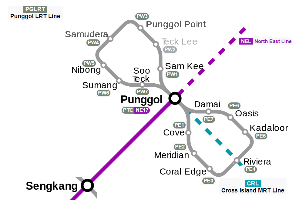
Teck Lee LRT station at a glance
| Station codes | PW2 |
|---|---|
| Lines | Punggol LRT (West Loop) |
| Line colour | Grey line (Punggol LRT (West Loop)) |
| Interchange | No, single line station |
| Chinese name | 德利 |
| Tamil name | டெக் லீ |
| Next stations |
See Teck Lee on the map. The interactive map opens with this station highlighted, so you can trace the route from where you are.
The main users are students and staff going to the Punggol campus of the Singapore Institute of Technology, and commuters changing to buses at Punggol Coast Bus Interchange. The station also serves visitors to Saint Francis Xavier Major Seminary, people heading to Punggol Waterway Park, and residents of the nearby housing.
History of Teck Lee LRT station
Teck Lee opened to passengers on 15 August 2024, nearly two decades after its structure was completed in 2004. It stayed closed while the land around it was developed, and after Samudera began operating in 2017 it was the only Punggol LRT stop still waiting to open. In May 2024 the Singapore Institute of Technology briefly said on its website that the station would open in August, then removed the mention because the details had not been finalised. The official announcement followed in July, which allowed the station to open in time for the university’s new Punggol campus in September.
Inside Teck Lee LRT station
The station has lifts, wider fare gates for wheelchair users and tactile flooring to guide passengers with visual impairments from the entrance to the platform. Fixed half-height barriers line the platform edges. They were installed in December 2017, as they were at other LRT stations, and are used instead of sliding screen doors because the platforms are narrow and the LRT signalling differs from the MRT’s. There are two exits, both leading towards the campus, the bus interchange and the waterfront.
For most people, Teck Lee LRT station is the nearest rail stop for a meal, a bus connection or a day out by the water. Punggol Coast Hawker Centre is about a four-minute walk away and is the closest place for an inexpensive meal. Families with young children can reach Splash @ Kidz Amaze, a water play area, in around five minutes, and Punggol Coast Bus Interchange is a similar distance for onward bus journeys. The Singapore Institute of Technology campus is roughly an eight-minute walk. For shopping, Waterway Point is about 14 minutes away on foot, and Northshore Plaza I and II are closer, at around 11 and 13 minutes.
Around Teck Lee LRT station
Teck Lee station sits within a newer residential district in Punggol, surrounded by public housing estates and community facilities. The nearby Punggol Coast Hawker Centre and Punggol Coast Bus Interchange reflect the area's role as a local neighbourhood hub. The Singapore Institute of Technology adds an educational presence to what is otherwise a largely residential part of the Punggol waterfront.
| Place | Type | Distance | Why go |
|---|---|---|---|
| Punggol Coast Hawker Centre | Food centre | About 240 m (~4 min walk) | Visit for a wide variety of local hawker food and drinks. |
| Splash @ Kidz Amaze | Water park | About 300 m (~5 min walk) | Visit for outdoor water play attractions suitable for children. |
| Punggol Coast Bus Interchange | Bus interchange | About 330 m (~5 min walk) | Use this interchange to connect to bus services across Punggol and beyond. |
| Wholesome | Food centre | About 460 m (~7 min walk) | Visit for another local food centre option with cooked food stalls. |
| Singapore Institute of Technology | University | About 520 m (~8 min walk) | Visit for a university campus serving undergraduate and continuing education students. |
| Northshore Plaza I | Shopping mall | About 660 m (~11 min walk) | Visit for retail shops, dining outlets and everyday services. |
| Northshore Plaza II | Shopping mall | About 810 m (~13 min walk) | Visit for additional retail and dining options alongside Northshore Plaza I. |
| Waterway Point | Shopping mall | About 850 m (~14 min walk) | Visit for a large shopping mall with supermarket, dining and leisure options. |
Places and straight-line distances from OpenStreetMap data (© OpenStreetMap contributors). Actual walking routes may be longer.
How to get to Teck Lee by LRT
Worked out from the network map. Stop counts are station to station and do not include walking or waiting time.
| From Changi Airport | Take the East West Line from Changi Airport to Paya Lebar (6 stops), then change to the Circle Line from Paya Lebar to Serangoon (4 stops), then change to the North East Line from Serangoon to Punggol (5 stops), then change to the Punggol LRT from Punggol to Teck Lee (2 stops). About 17 stops with 3 changes. |
|---|---|
| From Orchard | Take the North South Line from Orchard to Dhoby Ghaut (2 stops), then change to the North East Line from Dhoby Ghaut to Punggol (11 stops), then change to the Punggol LRT from Punggol to Teck Lee (2 stops). About 15 stops with 2 changes. |
| From City Hall | Take the North South Line from City Hall to Dhoby Ghaut (1 stop), then change to the North East Line from Dhoby Ghaut to Punggol (11 stops), then change to the Punggol LRT from Punggol to Teck Lee (2 stops). About 14 stops with 2 changes. |
| From Jurong East | Take the East West Line from Jurong East to Buona Vista (3 stops), then change to the Circle Line from Buona Vista to Serangoon (8 stops), then change to the North East Line from Serangoon to Punggol (5 stops), then change to the Punggol LRT from Punggol to Teck Lee (2 stops). About 18 stops with 3 changes. |
| From Woodlands | Take the North South Line from Woodlands to Bishan (8 stops), then change to the Circle Line from Bishan to Serangoon (2 stops), then change to the North East Line from Serangoon to Punggol (5 stops), then change to the Punggol LRT from Punggol to Teck Lee (2 stops). About 17 stops with 3 changes. |
| From HarbourFront | Take the North East Line from HarbourFront to Punggol (15 stops), then change to the Punggol LRT from Punggol to Teck Lee (2 stops). About 17 stops with 1 change. |
Fares from Teck Lee LRT station
A trip from Teck Lee to Changi Airport (about 27 km) costs S$2.43 on an adult SimplyGo or EZ-Link card. Fares are charged by distance, so the table below shows the estimated adult card fare from Teck Lee to the main hubs, the early bird fare for journeys that start before 7.45am on weekdays, and the fare that applies from 26 December 2026.
| To | Distance | Adult card | Before 7.45am | From 26 Dec 2026 |
|---|---|---|---|---|
| Changi Airport | about 27 km, 17 stops | S$2.43 | S$1.93 | S$2.56 |
| Orchard | about 18 km, 15 stops | S$2.20 | S$1.70 | S$2.33 |
| City Hall | about 17 km, 14 stops | S$2.20 | S$1.70 | S$2.33 |
| Raffles Place | about 19 km, 15 stops | S$2.24 | S$1.74 | S$2.37 |
| Jurong East | about 28 km, 18 stops | S$2.45 | S$1.95 | S$2.58 |
| Woodlands | about 29 km, 17 stops | S$2.46 | S$1.96 | S$2.59 |
| HarbourFront | about 22 km, 17 stops | S$2.33 | S$1.83 | S$2.46 |
| Marina Bay | about 21 km, 19 stops | S$2.30 | S$1.80 | S$2.43 |
Estimated from the route distance between stations and the Public Transport Council fare table in force from 27 December 2025. The exact fare can differ by one band. Cash fares are higher. Use the fare calculator for any other journey, or check your fare on the SimplyGo app.
Tips for using Teck Lee LRT station
- Punggol Coast Hawker Centre and Splash @ Kidz Amaze are both within a short walk of about five minutes, making them easy to reach on foot.
- For Waterway Point and the two Northshore Plaza malls, allow around 11 to 14 minutes on foot or consider taking a bus from Punggol Coast Bus Interchange to save time.
- During peak hours, the Punggol LRT West Loop can be busy, so allow a few extra minutes when travelling to or from the station.
- Punggol Coast Bus Interchange is roughly five minutes on foot and offers useful connections if you are heading to destinations not easily reached by LRT.
All stations on the Punggol LRT (West Loop)
In order along the line, with Teck Lee marked. Stations with their own guide are linked.
| Code | Station | Interchange |
|---|---|---|
| PW1 | Sam Kee | None |
| PW2 | Teck Lee (you are here) | None |
| PW3 | Punggol Point | None |
| PW4 | Samudera | None |
| PW5 | Nibong | None |
| PW6 | Sumang | None |
| PW7 | Soo Teck | None |
Read the full Punggol LRT (West Loop) guide.
Teck Lee LRT station: common questions
Which line is Teck Lee LRT station on?
Teck Lee is on the Punggol LRT (West Loop). Its station code is PW2.
Is Teck Lee an interchange station?
No. Teck Lee is served by the Punggol LRT (West Loop) only. The nearest interchange is shown in the next stations row above.
What is near Teck Lee LRT station?
Nearby places include Punggol Coast Hawker Centre at approximately 240 metres, Splash @ Kidz Amaze at approximately 300 metres, Punggol Coast Bus Interchange at approximately 330 metres, and the Singapore Institute of Technology at approximately 520 metres.
Which food centre is closest to Teck Lee station?
Punggol Coast Hawker Centre is the closest food centre, at approximately 240 metres from the station, which is roughly a four-minute walk.
How far is Waterway Point from Teck Lee station?
Waterway Point is approximately 850 metres from Teck Lee station, which is roughly a 14-minute walk.
How do I get to Teck Lee from Changi Airport by LRT?
Take the East West Line from Changi Airport to Paya Lebar (6 stops), then change to the Circle Line from Paya Lebar to Serangoon (4 stops), then change to the North East Line from Serangoon to Punggol (5 stops), then change to the Punggol LRT from Punggol to Teck Lee (2 stops). About 17 stops with 3 changes.
Sources: station codes, line colours and interchanges from the LTA rail system map; operating hours from SMRT and SBS Transit. Last reviewed October 2026.
News and guides mentioning Teck Lee
- シンガポールMRT路線図 2026(日本語ガイド) 4 Oct 2026
- Sengkang-Punggol LRT 11 Aug 2023
- Tamil 11 Aug 2023
- MRT Map Chinese 11 Aug 2023
Plan the rest of the trip
Every station on the Punggol LRT (West Loop) is listed on its line guide, with the full route and interchanges. For times, see the first and last train guide, and for the whole network in one view use the interactive Singapore MRT map or the PDF map.